

Rhode Island map
Newport County map
About 83,468 people live here (Census Bureau, 2024 estimate). The sheet's index lists 300 streets; West Main Road, East Main Road and Walnut Street cross the most grid squares. Things to do inside the boundary: Bally's Tiverton Casino and Hotel, Beavertail State Park and Bellevue Avenue Historic District.
Open the map (PDF, US Letter)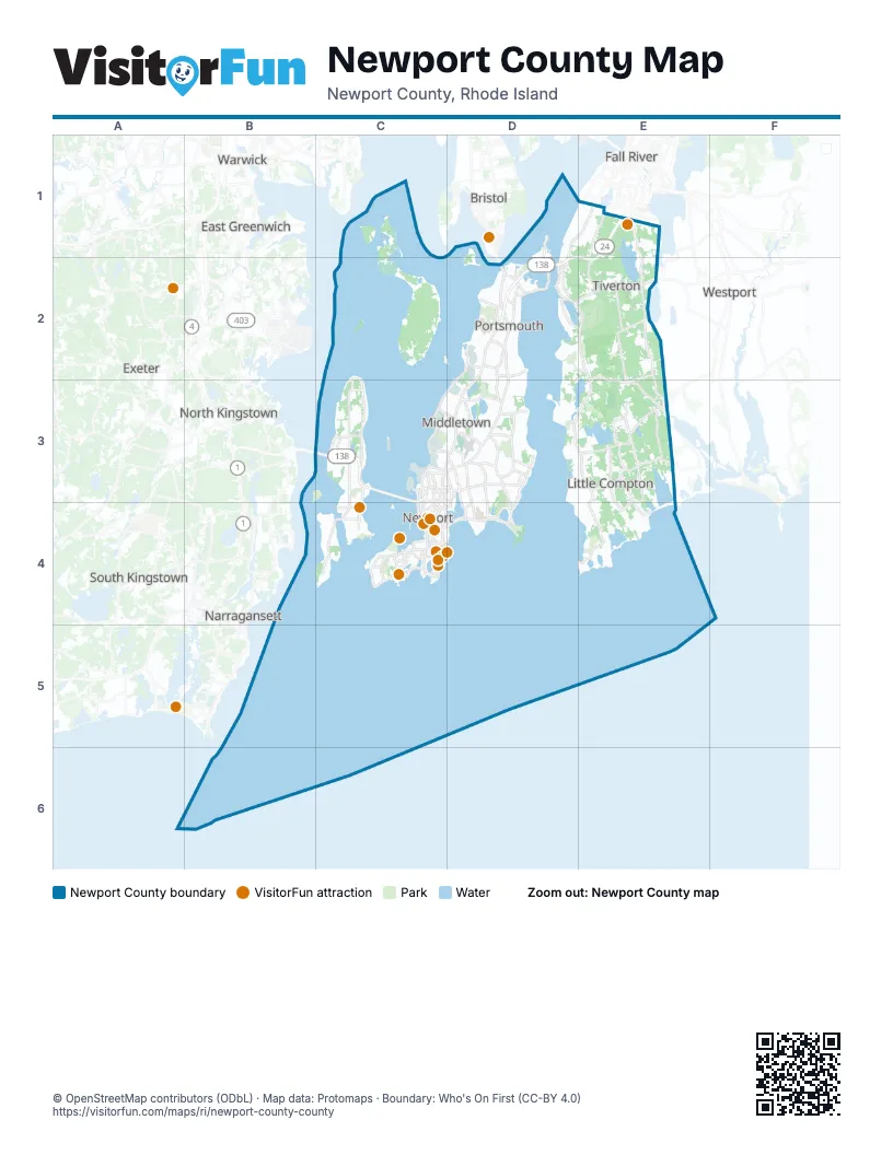
Street index of Newport County
Each street on the sheet and the grid squares it crosses.
- Newport BridgeB5, C5
- Jamestown Verrazzano BridgeA4
- RI 138D2
- RI 24D2
- West Main RoadD2, C3, D3, C4, E4, C5, E5, E6
- East Main RoadD2, D3, C4, D4, E4, C5, E5
- Aquidneck AvenueD2, C4, C5
- BroadwayB3, C3, C5
- Memorial BoulevardC5
- Bristol Ferry RoadD2
- Boyds LaneD2
- Admiral Kalbfus RoadC5
- JT Connell HighwayC5
- America's Cup AvenueC5
- Turnpike AvenueD2, D3
- Purgatory RoadC5
- Coddington HighwayC5
- Halsey BoulevardC5
- Farewell StreetC5
- Memorial Boulevard WestC5
- Mount Hope BridgeD2
- Mussel Bed Shoal RoadD2
- East MainD2
- Marlborough StreetC5
- JT Connell ConnectorC5
- West Marlborough StreetC5
- Main RoadE1, D2, E2, E3, E4
- Crandall RoadE2, E3, F3, F4
- East Shore RoadB3, B4, B5
- Narragansett AvenueC2, D2, C3, B5, C6
- Ocean AvenueB5, B6, C6
- Fish RoadE1, E2
- Bulgarmarsh RoadE2, F2
- North Main RoadB3, B4
- Green End AvenueC5, D5
- Harrison AvenueB3, C3, B6, C6
- Stafford RoadE1, E2
- East RoadE3, F3
- Bellevue AvenueC5, C6
- Valley RoadC4, C5
- North RoadC2, B4, B5
- Union StreetC4, D4, B5, C5
- Stone Church RoadE3, E4, F4
- Thames StreetC5, C6
- Spring StreetB5, C5, C6
- Coggeshall AvenueC6
- Conanicus AvenueB5
- Carroll AvenueC6
- Ridge RoadC2, B6
- Bay StreetE1, D2, B5
- Southwest AvenueB5
- Wellington AvenueB6, C6
- Miantonomi AvenueC5
- Castle Hill AvenueB6
- Touro StreetC5
- Main StreetF4
- Eldred AvenueB4
- Halidon AvenueB6, C6
- William S Canning BoulevardE1
- Morton AvenueC6
- Washington SquareC5
- Mariano Bishop BoulevardE1
- Mariano S Bishop BoulevardE1
- Burma RoadC3, C4
- Long HighwayE4, E5
- Beavertail RoadA5, B5, A6
- Wapping RoadD4, D5
- Middle RoadC2, D3, D4
- Anthony RoadD1, D2
- Indian AvenueD4, D5
- Third Beach RoadD5
- Maple AvenueB5, C5, E5
- Peckham RoadE4
- John Dyer RoadF4
- Lake RoadE3
- Mitchells LaneC4, D4, D5
- Seaside DriveA4, B4
- Brayton RoadE2, E3
- Colebrook RoadE4, F4
- Willow AvenueE4, C5, E5
- Nanaquaket RoadD2, D3, E3
- Paradise AvenueC5
- Park AvenueB2, D2, B3, B5
- Jepson LaneC4
- Brenton RoadB6, C6
- Sakonnet Point RoadE6
- King RoadE3, C5
- Highland RoadD2, E2
- Hanging Rock RoadC5, D5
- South of Commons RoadE3, F3, E5
- Ruggles AvenueC6
- High StreetB5, C5
- Wolcott AvenueC5
- Oliphant LaneC4
- Berkeley AvenueC4, C5
- Sandy Point AvenueD4
- 3rd StreetD2, C5
- Wyatt RoadC4, D5
- Sachuest Point RoadD5
- South Shore RoadE5, F5
- Beacon AvenueB4
- Eustis AvenueC5
- Stringham RoadC3
- Riverside DriveC2, D2
- Kay StreetC5
- Pottersville RoadE4, F4, E5
- Summit AvenueD2, B3, B4
- Burchard AvenueE4
- Beacon Hill RoadB6
- Rhode Island AvenueC5
- Hillside AvenueD2, C5
- Freeborn StreetD3, C5
- Forest AvenueB3, C4
- Greene LaneC4, C5
- Mullin Hill RoadF4, F5
- Bramans LaneC4, D4
- Gate 17 Access RoadC4
- Mill StreetE1, C5
- Washington StreetB5, C5
- Peckham AvenueC5, D5
- Old Beach RoadC5
- McCorrie LaneD3
- Willow LaneC2, D2
- BoulevardC5
- Old Mill LaneD4, D5
- Malbone RoadC5
- Vaucluse AvenueD5
- Van Zandt AvenueC5
- Meeting House LaneE5
- Hamilton AvenueB5
- Girard AvenueC5
- Bliss RoadC5
- Walcott AvenueB5
- Hedly StreetC3, D3
- Simmons RoadE5
- Snell RoadE5
- Sprague StreetD2
- Brownell RoadE5
- Hammersmith RoadB6
- Mill LaneC3, D3
- Tasshtassuc RoadA4, B4
- Frigate StreetA4, B4
- Annandale RoadC5, C6
- Warner StreetC5
- Tompkins LaneE4
- Gladys Carr Bolhouse RoadB5, C5
- Alexander RoadC3
- Bliss Mine RoadC5
- Training Station RoadB5, C5
- Carr LaneB4
- Schoolhouse LaneE1, D3
- Friendship StreetB5, C5
- Kay BoulevardC5
- John Sisson RoadE5
- Point RoadD2
- Central AvenueD2
- Bedlow AvenueC5
- East Bowery StreetC5
- Pelham StreetC5
- Old Fort RoadC6
- Evans AvenueD2
- Helm StreetA4
- Railroad AvenueD2
- Dr Marcus Wheatland BoulevardC5
- Hull StreetA4
- Bridge StreetC5
- Hummocks AvenueD2
- Freebody StreetC5
- Hummock Point RoadD2
- Wickham RoadB6, C6
- Long WharfC5
- Bowery StreetC5
- Summer StreetB3, D3, C5
- Westport Harbor RoadF4
- CommonsE5
- Commons StreetE5
- Town Landing RoadE6
- Commercial StreetC5
- Young StreetC5
- Equality Park WestC5
- Old Harbor RoadF4
- Seapowet AvenueD3, E3
- Neck RoadD3, E3, D4
- Neck Farm RoadB2, C2
- Eagleville RoadE1
- Bay AvenueB2, C2, B3
- Corys LaneE2, F2, C3
- Albro Farm RoadB3
- Fort Getty RoadA5
- Highland DriveB5, B6
- Black Point LaneD4
- Meadow LaneC4, B5, E5
- Old Main RoadE1, E3, E4
- Eight Rod WayE3, E4
- Tuckerman AvenueC5
- South Reserve DriveB3, C3
- Turner RoadC4, C5
- Rogers LaneC4, E5, F5
- West Reach DriveB4
- Swamp RoadE5
- Cornell RoadE2, E3
- Cunningham StreetC4
- Gibbs AvenueC5
- Lepes RoadE1, D3
- America WayB4
- East End Sportsmans Club RoadE1, F1
- Sea Meadow DriveD3
- Browns LaneC4
- Canonicus StreetE1
- Arruda's LaneE1, F1
- Hooper StreetE1
- Seal Rock RoadC3
- East Shore DriveC3
- Oak Forest DriveC4, E4
- Lincoln DriveB6
- Judson StreetE1, D2
- Water StreetD2, D3
- Reservoir RoadC5
- Fort Adams DriveB6
- Three Rod WayE1, D4
- Linden LaneD4
- Peary StreetC4, B5, C5
- Freedom Trail DriveC4
- Vanderbilt LaneD3
- Simonpietri DriveC4, C5
- Amesbury LaneE4, F4
- Bradford AvenueC3, C5
- Howland AvenueB5, D5
- T-Wharf RoadB3, C3
- Prospect AvenueB4, C5
- Shaw RoadE5
- Walnut StreetE1, B2, D2, B5, C5, B6
- Schooner DriveD1, D2, E2
- Mount Pleasant AvenueB3, C3
- Southlake RoadE3, E4
- Beach AvenueD2, A4, C5
- South Carnegie Beach DriveC2, D2
- Hilltop DriveC2, C3, D3
- Indian Hill RoadE2, C5, E5
- Mount Hope AvenueC2, D2, B5
- Village RoadD1, E1, D2
- Intrepid LaneB4
- Racquet RoadB5
- Webster StreetC6
- Taylor RoadD4, B5
- Atlantic AvenueB2, D2, B3, B6
- Quicksand Pond RoadE5, F5
- Souza RoadE2
- Glen RoadD4
- Levsque Memorial DriveB3, C3
- Ledge RoadB5, C6
- Church's LaneE5
- Meyerkord AvenueC4, C5
- Blueberry LaneE2, B5
- Cliff AvenueD2, C5
- Briarwood AvenueE1, C5
- Holly Berry Hill RoadE5
- King Charles DriveC3
- Hazard RoadB6, C6
- Elliot AvenueB5, C5
- Butts Rock RoadE5, F5
- Windstone DriveD3
- Glen Farm RoadD4
- Warren AvenueE1, C5
- Grange AvenueE5
- Winery RoadE4
- Cottrell RoadE2
- Church StreetE1, C5
- Bay View DriveB5
- Old Stone Church RoadE4, F4
- Compton View DriveC5
- Fort Wetherill RoadB5
- Gondola AvenueB4
- Warren Point RoadE6
- Pocasset Hill CemeteryE1
- Beach RoadB2, C2
- Round Pond RoadE6
- John H. Chafee BoulevardC5
- Bettencourt LaneE4
- Governor Paine RoadC2, C3
- Riverside StreetD2
- Lay StreetC4
- Dexter StreetD2, C5
- Winnisimet DriveD3, E3
- Richard DriveE1, D2
- Progress RoadE2
- Rockbridge DriveF5
- Rolling Hill RoadC3
- Bridle WayE2, F2
- Hilton StreetE1
- Deer Run RoadE2
- 2nd StreetD2, C5
- Columbia LaneB4
- Bonniefield DriveD3, D4
- Weeden LaneB5
- Briggs BeachE5, E6
- Elm StreetC4, B5, C5
- Rhode Island BoulevardD2
- Fischer CircleD4
- Atlantic DriveC5, E6
Things to do on the Newport County map
- Bally's Tiverton Casino and Hotel
- Beavertail State Park
- Bellevue Avenue Historic District
- Brenton Point State Park
- Cliff Walk
- Coastal Queen Cruises
- Fort Adams State Park
- Fort Wetherill State Park
- Gansett Cruises
- Green Animals Topiary Garden
- International Tennis Hall of Fame
- Jamestown Newport Ferry
- Kingscote
- Marble House
- Museum of Newport History
- National Museum of American Illustration
- Newport Classic Cruises
- Newport Tower
- Ocean Drive
- Rosecliff
- Sightsailing of Newport
- The Breakers
- The Elms
- Touro Synagogue
Places on the map
- Aquidneck Corporate Park
- Baker Farm
- Beavertail State Park
- Blount Parcel
- Blue Bill Cove
- Briggs Marsh
- Bumblebee Pond
- Chipaquisset Park
- Dundery Brook
- Dutch Island
- Easton Pond
- Easton's Beach
- Eight Rod Farm
- Emilie Ruecker Wildlife Refuge
- Eugene Chase Farm
- Gardiner Pond
- Goose Neck Cove
- Green End Pond
- Green Valley Country Club
- Hope Island
- Jamestown
- Jenny Pond
- Lawton Valley Reservoir
- Little Compton
- Mary C Donovan Marsh
- Melville
- Middletown
- Montaup Country Club
- Nannaquaket Pond
- Narragansett Bay National Estuarine Research Reserve
- Naval Station Newport
- Newport
- Newport Country Club
- Newport East
- Newport National Golf Club
- Nonquit Pond
- Norman Bird Sanctuary
- Pardon Gray Preserve
- Portsmouth
- Quicksand Pond
Next to Newport County
- Bristol
- Saunderstown
© OpenStreetMap contributors, Open Database License, openstreetmap.org/copyright · Map data: Protomaps · Boundary: Who's On First (CC-BY 4.0)