

Rhode Island map
Newport map
About 24,482 people live here (Census Bureau, 2024 estimate). The sheet's index lists 300 streets; Ocean Avenue, Harrison Avenue and Bellevue Avenue cross the most grid squares. Things to do inside the boundary: Bellevue Avenue Historic District, Cliff Walk and International Tennis Hall of Fame.
Open the map (PDF, US Letter)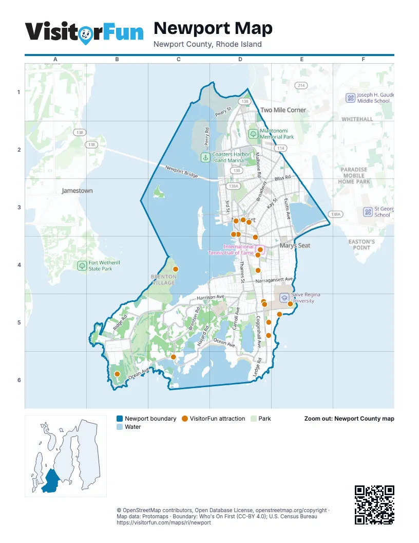
Street index of Newport
Each street on the sheet and the grid squares it crosses.
- Newport BridgeC2, C3, D3
- Memorial BoulevardE3, D4, E4
- Admiral Kalbfus RoadD2, E2
- JT Connell HighwayD1, D2, D3
- America's Cup AvenueD3, D4
- BroadwayD2, E2, D3
- Halsey BoulevardD2
- Farewell StreetD3
- Memorial Boulevard WestD4
- Coddington HighwayD1
- Marlborough StreetD3
- JT Connell ConnectorD2
- West Marlborough StreetD3
- Purgatory RoadE3
- Ocean AvenueB5, C5, D5, B6, C6, D6
- Harrison AvenueB5, C5, D5, B6
- Bellevue AvenueD3, D4, D5, D6
- Thames StreetD3, D4
- Spring StreetD3, D4
- Coggeshall AvenueD4, D5, D6
- Carroll AvenueD4, D5
- Narragansett AvenueD4, E4
- Ridge RoadB5
- Wellington AvenueC4, D4
- Castle Hill AvenueB5
- Touro StreetD3
- Halidon AvenueC4, D4, D5
- Morton AvenueD4
- Washington SquareD3
- Brenton RoadC5, D5, C6
- Ruggles AvenueD5, E5
- Eustis AvenueE2, E3, E4
- 3rd StreetD2, D3
- Kay StreetD3, E3
- Beacon Hill RoadC5
- Rhode Island AvenueD3, E3, E4
- Old Beach RoadD3, E3, D4
- Hillside AvenueD1, D2
- Malbone RoadD2, D3
- Van Zandt AvenueD2, D3
- Washington StreetD3
- Girard AvenueD1, D2
- Bliss RoadE2, D3, E3
- Hammersmith RoadC5
- Annandale RoadE4
- Warner StreetD3
- Gladys Carr Bolhouse RoadC3, D3
- Training Station RoadC2, D2
- Maple AvenueD1
- Kay BoulevardE3
- Freeborn StreetE2
- Bedlow AvenueD2, E2
- East Bowery StreetD4, E4
- Pelham StreetD3, D4
- Mill StreetD3, D4
- Friendship StreetD3, E3
- Old Fort RoadD5
- Dr Marcus Wheatland BoulevardD3
- Bridge StreetD3
- Freebody StreetD4
- Wickham RoadC5, D5
- Long WharfD3
- Bowery StreetD4
- Summer StreetD2, D3
- Young StreetD4
- Equality Park WestD3
- Gibbs AvenueD2, D3, E3, E4
- Lincoln DriveB4, C4, B5, C5
- Fort Adams DriveC4, C5
- Peary StreetD1, C2
- Webster StreetD4, E4
- Meyerkord AvenueD1, D2
- Hazard RoadC5, D5
- Elliot AvenueC1, D1, D2
- John H. Chafee BoulevardD1, D2
- Perry RoadC2
- Catherine StreetD3, E3
- 2nd StreetD3
- Whipple StreetD1
- Victoria AvenueD5, E5
- Shepard AvenueD5, E5
- Ochre Point AvenueE4, E5
- Ledge RoadD6
- Leroy AvenueD4, E4
- Prices Neck RoadC6
- Cushing RoadC2
- Ayrault StreetD3, E3
- Evarts StreetD2, D3
- Lawrence AvenueE4, E5
- Marchant StreetD4, D5
- Middleton AvenueE4
- Luce AvenueC2
- Ellery RoadE3
- Everett StreetD3, E3
- Capodanno DriveC1, D1
- Goat Island RoadC3
- 3rd Street ExtensionD2
- Cliff AvenueE4
- Chartier CircleB5
- Roseneath AvenueD4, D5
- Merton RoadD4, E4
- Berkeley AvenueD4, E4
- Bateman AvenueD5
- Hunter AvenueE3
- Prospect Hill StreetD4
- Dudley AvenueD2, E2
- Garfield StreetD2
- Halsey StreetD1, D2, D3
- Barschow StreetC1
- Hall AvenueD2, D3
- Kingston AvenueD3
- Dixon StreetD4
- Eastnor RoadD5
- Parker AvenueD4, E4
- Houston AvenueD4, D5
- Jackson RoadC4
- Chastellux AvenueD4, D5
- Prairie AvenueE3
- Poplar StreetD3
- Ocean Lawn LaneE4
- Church StreetD3
- Defenders RowC3, C4
- Powell AvenueD3, E3
- Greenough PlaceD3
- Bliss Mine RoadE3
- Elm StreetD3
- Toppa BoulevardE2, E3
- Holten AvenueE2, E3
- Keeher AvenueE2, E3
- Connection StreetD4
- Fort Adams State ParkC4
- Jeffrey RoadD5
- Red Cross AvenueE3, E4
- McCormick RoadD5
- Winans AvenueB5, B6
- ElmD3
- Cherry Creek RoadC5
- West Narragansett AvenueD4
- Clinton StreetD4
- Donovan AvenueC1, D1
- Ocean Heights RoadD5
- Mary StreetD3
- John StreetD4
- Gould StreetD3
- Dexter StreetD2
- Mount Vernon StreetD3
- Coast Guard Station RoadB5
- William StreetD4
- Monroe RoadC4
- Champlin StreetE3
- Spouting Rock DriveD5
- Homer StreetD2, D3
- Ward AvenueD4, E4
- Cranston AvenueD3
- Riggs RoadD2
- Chapel StreetD3, D4
- Marine AvenueD5, E5
- Thurston AvenueD2, E2
- Atlantic AvenueB6
- Bull StreetD3
- Porter AvenueC2, D2
- Taylor RoadC2
- West Evans StreetD1
- Alpond DriveD5
- Bulldog BoulevardC1, D1
- Whitwell AvenueE3
- Weaver AvenueD4, E4
- FernD3
- Faxon GreenE4
- Mann AvenueD3
- Fenner AvenueE2
- Truman StreetD2
- Shimoda WayD1, D2
- Fitzsimmons RoadD2
- Madeline DriveD2
- Smith RoadD2
- Dyre AvenueD3
- Newport AvenueD3
- Sunset BoulevardD2
- Division StreetD3
- Vernon AvenueE2
- Commonwealth AvenueB5, B6
- Willow StreetD3
- Hampshire DriveC2
- Prescott Hall RoadD2, D3
- Tilden AvenueD3
- BeechD3
- Slocum StreetD4, E4
- Canonicus AvenueD2, E2
- Weatherly AvenueD5
- Sheffield AvenueD2
- Burnside AvenueD3
- HemlockD3
- Columbus AvenueD4
- Sherman StreetD3
- Callendar AvenueD3
- Perry StreetD4
- Beacon CourtD2
- Reliance RowD1
- Pope StreetD4
- Pond AvenueD3
- Calvert StreetD3
- Southmayo StreetD2
- Earl AvenueD4, D5
- Gammell RoadE4
- Harbor View DriveD4
- Channing StreetD3
- Liberty StreetD3, D4
- Dresser StreetE4
- Smith AvenueD2
- Cherry StreetD3
- Carey StreetD4
- Weenachasett StreetD2
- Atlantic StreetD4
- Vaughan AvenueD4, D5
- Beacon StreetD2
- Ledyard StreetE2
- Walnut StreetD3
- FuschiaD3
- Jackson CourtC4
- Burdick AvenueD2
- Clay StreetD4
- Butler StreetD2, D3
- AcaciaD3
- Bambridge RoadC2
- Ranger RoadD1
- Annandale TerraceE4
- Charles StreetD3
- Russell AvenueD2
- Barney StreetD3
- Caswell AvenueE2
- Hammond StreetD4
- Seaview AvenueE4
- Easton StreetD1, D2
- King StreetD4
- Lakeview AvenueD6
- America StreetC4
- Florence AvenueD5
- Friendship DriveE3
- Almy StreetE2
- Exchange StreetD1
- Brinley StreetD3
- Hopkins AvenueC2
- LindenD3
- Tilley AvenueD3
- Clinton AvenueD3
- DaisyD3
- Mumford AvenueD2
- Ella TerraceB5
- Aborn StreetE3
- Mc Allister StreetD4
- Congdon AvenueD3
- Edward StreetD3
- Peckham AvenueD2, E2
- Polk RoadC4
- Champlin Place NorthE3
- LocustD3
- Brooks AvenueD2, E2
- Boughton RoadD2
- Arnold AvenueD2
- Capella Street SouthC3, C4
- Waites WharfD4
- Lee AvenueD4
- Palmer StreetD5
- Howe AvenueD4
- Pennacook StreetD2
- Sycamore StreetD3
- Knight RoadC2
- Dean AvenueD4
- Pine StreetD3
- Rovensky AvenueD5
- Greene LaneD2, E2
- Bayside AvenueD2, D3
- Vicksburg PlaceD3
- Bayview AvenueD3
- Sylvan StreetD4
- Cliff TerraceE4
- Holland StreetD4
- Heath StreetD3
- Manning TerraceE3
- Meikle AvenueD4, D5
- Clarke AvenueD3
- Enterprise CourtD2
- Kempsen StreetE3
- Belmont AlleeD3
- Chaplain's WayC1, D1
- Hazard AvenueD5
- Resolute RoadD2
- Simmons StreetD4
- Dearborn StreetD4
- Cypress StreetD2
- Jefferson RoadC4
- County StreetE2
- Grafton StreetD4
- Cummings RoadD2
- Hope StreetD3, E3
- Edgar CourtD4, E4
- Loyola TerraceE3
- Stockholm StreetD4
- Park StreetD3
Things to do on the Newport map
- Bellevue Avenue Historic District
- Cliff Walk
- International Tennis Hall of Fame
- Marble House
- Newport Classic Cruises
- The Breakers
- Brenton Point State Park
- Coastal Queen Cruises
- Fort Adams State Park
- Gansett Cruises
- Kingscote
- Museum of Newport History
- National Museum of American Illustration
- Newport Tower
- Ocean Drive
- Rosecliff
- Sightsailing of Newport
- The Elms
- Touro Synagogue
Places on the map
- Almy Pond
- Almy Pond Conservation Area
- Bailey Beach
- Beacon Hill
- Braga Park
- Brenton Point State Park
- Brick Market Place
- Broadway Post Office
- Castle Hill
- Coasters Harbor Island Marina
- Common Ground Cemetery
- Easton Pond
- Easton's Beach
- Fort Adams
- Fort Adams State Park
- Goat Island
- Goose Neck Cove
- Gooseberry Island
- Henry E. Eccles Library
- Ina Mosher Health Sciences Library
- International Tennis Hall of Fame
- Island Cemetery
- King Park
- Lily Pond
- McCool Track
- Miantonomi Hill
- Miantonomi Memorial Park
- Morton Park
- Naval Hospital Medical Library
- Newport Country Club
- Newport Historical Society Library
- Newport Hospital
- Newport Marina
- Parade
- Pritchard Field
- Rose Island
- Salve Regina University
- Ward 1
- Ward 2
- Ward 3
Next to Newport
- Easton's Point
- Jamestown
- Paradise Mobile Home Park
- Two Mile Corner
- Whitehall
© OpenStreetMap contributors, Open Database License, openstreetmap.org/copyright · Map data: Protomaps · Boundary: Who's On First (CC-BY 4.0); U.S. Census Bureau















