

Rhode Island map
Portsmouth map
About 17,391 people live here (Census Bureau, 2024 estimate). The sheet's index lists 300 streets; West Main Road, East Main Road and Narragansett Avenue cross the most grid squares. Things to do inside the boundary: Green Animals Topiary Garden.
Open the map (PDF, US Letter)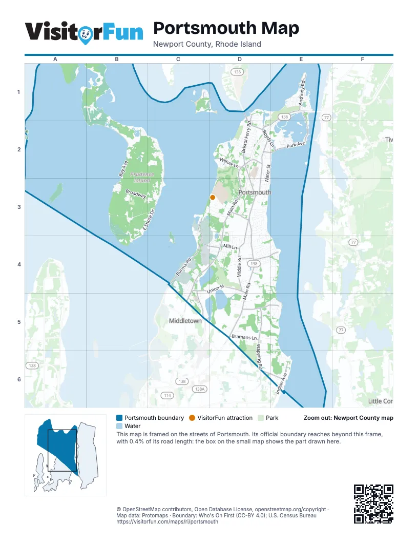
Street index of Portsmouth
Each street on the sheet and the grid squares it crosses.
- East Main RoadD2, D3, D4, D5
- West Main RoadD2, D3, C4, D4, C5
- Bristol Ferry RoadD1, D2
- Boyds LaneD2, E2
- Turnpike AvenueD2, D3
- Mount Hope BridgeD2
- Mussel Bed Shoal RoadD1, D2
- East MainD2
- Union StreetC4, D4
- Middle RoadC1, D3, D4
- Anthony RoadE1, D2, E2
- Wapping RoadD5, D6
- Burma RoadC3, C4
- Park AvenueD2, E2, B3
- Sandy Point AvenueD5, E5
- Stringham RoadC3, C4, D4
- Indian AvenueE6
- Bramans LaneD5
- Jepson LaneC4, C5
- McCorrie LaneD4, E4
- Willow LaneD2
- Old Mill LaneD6, E6
- Hedly StreetD3
- Sprague StreetD2
- Mill LaneD4
- Alexander RoadC3
- Schoolhouse LaneD4
- Point RoadE2
- Mitchells LaneD5
- Railroad AvenueE1
- Hummocks AvenueE1
- Hummock Point RoadE1, E2
- Narragansett AvenueB2, C2, D2, C3
- Neck Farm RoadB1, B2
- Bay AvenueB2, B3
- Albro Farm RoadB3
- BroadwayB3, C3
- Black Point LaneD5, E5, D6, E6
- South Reserve DriveB3, C3
- Sea Meadow DriveD3
- Seal Rock RoadB3, B4
- East Shore DriveB3, C3
- Water StreetD2, E2, D3
- Linden LaneD5
- Vanderbilt LaneD4, E4
- T-Wharf RoadB3, B4
- Mount Pleasant AvenueB3
- South Carnegie Beach DriveD2
- Hilltop DriveC1, D3, D4
- Bradford AvenueC3, D3, D4
- Glen RoadD4, E4
- Corys LaneD3
- Levsque Memorial DriveB3, B4
- Freedom Trail DriveC4, C5
- King Charles DriveC3, D3
- Windstone DriveD4, E4
- Glen Farm RoadD4, D5
- Beach RoadC1, B2
- Governor Paine RoadC2, C3
- Riverside StreetE2
- Rolling Hill RoadC4
- Rhode Island BoulevardE1
- Fischer CircleE5
- Carriage DriveD4, D5
- Fairview LaneD3, D4
- Common Fence BoulevardE1
- Taylor RoadD5, E5
- Atlantic AvenueE2, B3
- Mott Farm RoadC3, D3
- West Shore RoadD2
- Freeborn StreetD3
- Ferry Landing CircleD1
- Brown RoadB3
- Greenvale RoadD5, E5
- Prospect LaneD3
- Daniels AvenueC2
- Wampanoag DriveD4
- Brownell LaneD2
- Chesawanoc AvenueC1
- Mail Coach RoadC4
- Eastover RoadE5
- Lawrence DriveD3
- Cottontail DriveE6
- Lepes RoadD3
- Sullivan DriveD3, C4, D4
- Newport Harbor DriveD2
- South Riverside DriveC1, D1
- Hargraves DriveD3
- Soares DriveD2
- Locust AvenueC1, D4
- Farmlands RoadD5, E5
- Cromwell DriveD3
- Lambie CircleD3
- Bayview TerraceD3
- Spring Hill RoadD4
- Cedar AvenueE2
- Oakland Farm RoadD5
- Redwood RoadC4
- Canonchet DriveD2, D3
- Narragansett BoulevardE1
- Cliff AvenueE1, E2
- Ethel DriveD3
- Moitoza LaneD5
- Chase RoadD2
- Young DriveD5
- Cimarron DriveC4, D4
- Heritage DriveD1, D2
- Massachusetts BoulevardE1
- Immokolee DriveD3
- Der. Vartanian StreetD4
- Frank Coelho DriveD4, E4
- Briarwood LaneD6, E6
- Dexter StreetD3
- Sakonnet DriveE1
- Gideon Lawton LaneD3
- Ferreira StreetD4
- Windward DriveD2
- Carnegie Harbor DriveD2
- Triple Bunker RoadB3
- Highpoint AvenueD3
- Sherwood TerraceD4
- Switchgrass LaneB3
- Viking DriveD2
- Devin DriveD3
- Cornelius DriveE6
- King Phillip StreetE1
- Bayview AvenueD1
- Potters Cove Access RoadB1
- Sweet Farm RoadD3, D4
- Stonegate DriveD4
- Adams DriveD5, E5
- Massasoit AvenueE1
- High Point AvenueD3
- Power StreetD3
- Rebels WayC4, C5
- Dawn Marie DriveD2
- Homestead AvenueC2
- West Passage DriveD3
- Pear StreetD4
- Almeida TerraceC4
- Henry Danis CourtD3
- Depot AvenueD2
- Woodland DriveD5
- Richard DriveD1, D2
- Greystone TerraceD4
- Prospect Farm RoadD3
- Quaker Hill LaneD3
- Valhalla DriveD2, E2
- Watson DriveD4
- Mount Hope AvenueC1, E1
- Pheasant DriveD2
- Carnegie Heights DriveD2
- Sherwood DriveD4
- Depot StreetD2
- Sunset Hill AvenueC2
- Elm StreetD5
- Cherokee DriveD2
- Evergreen DriveD4
- Ormerod AvenueE2
- Holman StreetD3
- Roger Williams CourtD4
- Windrock CircleD4
- Lilac LaneD4
- Belmont DriveD5
- Cottage AvenueE2
- Greenfield AvenueE1
- Holliston AvenueE1
- Davis StreetD4
- Gormley AvenueE2
- Islington AvenueE1
- Storm King DriveD5
- Dighton AvenueE1
- Island RoadE1
- Almy Knoll TerraceC4, C5
- Foxboro AvenueE1
- Memorial DriveD2
- Norseman DriveD2, E2
- Canton AvenueE1
- Col Christopher Greene RoadD5, E5
- Berkley AvenueE1
- Easton AvenueE1
- Peleg RoadD3, D4
- Raphael AvenueB2
- Camara DriveD2
- Seaconnet BoulevardE2
- Worden StreetD4
- Stony Brook LaneC4, C5
- Child StreetD2, E2
- Greylock DriveD4
- Malee TerraceD5
- Glen Meade DriveD5
- East LaneC2
- Harrison AvenueB3
- John Oldham RoadC3
- William StreetE4
- Newport Beach DriveD2
- Johnnycake LaneD2, D3
- Lawton Brook LaneC4
- Robin RoadD4, E4
- Mohawk DriveE6
- Scotty DriveD4
- Bayside AvenueD3
- Raymond DriveD4
- Donna DriveD4
- Long Meadow RoadD3
- Meadowlark LaneD5
- Highland AvenueE2
- South DriveD2
- Flanagan RoadD4
- Mason AvenueE2
- Schooner DriveD2
- Sigourney RoadE5
- Stage Coach RoadC4
- Walnut StreetE2, B3
- Log Bunker RoadB3, B4
- Botelho DriveD2
- Anson DriveD2
- Birchwood DriveD2
- SeaFare LaneD2
- Linda AvenueD2
- East TerraceE4
- Peggy LaneD3
- Amando DriveD3
- Riverside DriveC1, D1
- Carter DriveD6
- Ferreira TerraceD2, D3
- Stub Toe LaneD4
- Valley LaneD2
- Hillside RoadC2, D2
- McIntosh DriveD4
- Common Fence Point Access RoadE1
- Leander AvenueD4
- Grain TerraceD4
- Gilbert Barker RoadD4
- West Dexter StreetD3
- Chase WayB2
- North DriveD2
- Pier RoadC2
- Tallman AvenueD2, E2
- Rainbow HeightsD3
- Alan AvenueD2
- Bradley TerraceD3
- Cove StreetE2
- Flint Corn RoadD4
- Raynham AvenueE1
- Annette DriveE4
- Maize Corn RoadD4
- Benjamin DriveD4
- Buckwheat AvenueD4
- Concord AvenueB3
- Summit RoadE1
- Founders AvenueD2
- Old Pier RoadD1
- Carnegie Abbey LaneD2
- Ridge RoadC1
- Fairview AvenueC2
- Fieldstone DriveD4
- Madison WayD4
- Randolph WayD4
- Slocum RoadD5
- Wilkey AvenueD4
- Aquidneck AvenueE2
- Echo LaneD2
- Baker RoadD2
- Sunrise DriveD4, E4
- Clearview AvenueD4
- Potomac RoadD3
- Dorothy AvenueD4
- Harris AvenueD4
- Leeward ShoresD2
- Linda TerraceD4, E4
- Crestview PlaceD4
- Alden WayC3
- Sisson Pond RoadC5
- Prudence View DriveD4
- Dianne AvenueD5
- Homestead LaneD3
- Perrault StreetC5
- Oakdale AvenueE1
- Church LaneD3
- Sunset AvenueC1, D1, D2
- Cottage LoopB3
- Evans WayD2
- High Hawk RoadD4
- Pine Tree RoadD3
- Wimbledon CircleD2
- Bourbon StreetD2
- Morgan StreetE2
- Birch Bunker RoadB3, B4
- President StreetD2
- Hathaway DriveD4
- Alice AvenueC2
- Macomber LaneD3
- Warner AvenueB2
- Copper Beech DriveD5
- Petonanowet LaneD4
- Bayberry RoadE6
- Ann AvenueD2
- Army Camp RoadC2
- Heidi DriveE4
Things to do on the Portsmouth map
Places on the map
- Abbey Church of St Gregory The Great and Queen of Peace
- Almy Hill
- Baker Farm
- Blount Parcel
- Blue Bill Cove
- Boystown Fly-in-Ranch
- Butts Hill
- Chipaquisset Park
- Dyer Island
- Eugene Chase Farm
- Farnham Farm
- Green Valley Country Club
- Greenvale Vineyards
- Hope Island
- Jenny Pond
- Lawton Valley Reservoir
- Lehigh Hill
- Lower Melville pond
- Melville Ponds Campground
- Montaup Country Club
- Narragansett Bay National Estuarine Research Reserve
- Naval Station Newport
- New England Boatworks
- Newport Car Museum
- Newport National Golf Club
- Pheasant Drive Public Access Point
- Portsmouth Abbey School
- Portsmouth Abbey School Library
- Portsmouth High School
- Portsmouth Post Office
- Safe Harbor Island Park Marina
- Saint Marys Pond
- Sisson Pond
- Slate Hill
- Spectacle Island
- Teddy Beach
- The Aquidneck Club
- Turkey Hill
- Upper Melville Pond
Next to Portsmouth
- Little Compton
- Middletown map
© OpenStreetMap contributors, Open Database License, openstreetmap.org/copyright · Map data: Protomaps · Boundary: Who's On First (CC-BY 4.0); U.S. Census Bureau















