

South Carolina map
Myrtle Beach map
About 40,535 people live here (Census Bureau, 2024 estimate). The sheet's index lists 300 streets; Highway 17, North Kings Highway and Robert M. Grissom Parkway cross the most grid squares. Things to do inside the boundary: Myrtle Beach Boardwalk and Promenade, Ripley's Aquarium of Myrtle Beach and SkyWheel Myrtle Beach.
Open the map (PDF, US Letter)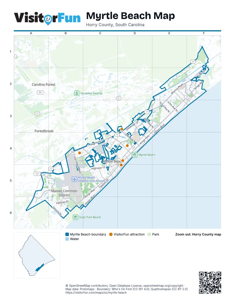
Street index of Myrtle Beach
Each street on the sheet and the grid squares it crosses.
- Highway 17E2, F2, D3, E3, B4, C4, D4, A5, B5, A6
- North Kings HighwayE2, F2, D3, E3, D4, E4, C5, D5
- Robert M. Grissom ParkwayE2, D3, E3, B4, C4, D4
- South Kings HighwayC5, B6, C6
- US Highway 17 Bypass SouthA5, A6
- 67th Avenue NorthE3
- Main StreetC4, D4
- Socastee BoulevardA5
- Mark Garner HighwayF2
- Waterside DriveB4
- Farrow ParkwayA5, B5, B6
- Harrelson BoulevardB4, B5, C5
- North Ocean BoulevardF2, E3, D4, E4, C5, D5
- 21st Avenue NorthC4, D4
- Mr. Joe White AvenueC3, C4, D4
- North Oak StreetD4, C5
- Ocean BoulevardF2, E3, F3, E4, C5
- South Ocean BoulevardC5, B6, C6
- 29th Avenue NorthD3, D4
- 82nd ParkwayE2, F2
- Highway 15B5, C5
- 38th Avenue NorthD3, D4
- BroadwayC4, D4, C5
- 48th Avenue NorthD3, E3
- 79th Avenue NorthE2, F2, F3
- 3rd Avenue SouthC4, C5
- Jetport RoadB5, C5
- 8th Avenue NorthC4, D4, D5
- 47th Avenue NorthD3, E3, E4
- Fantasy Harbour BridgeB4
- Seaboard StreetB4, C4
- Grande Dunes BoulevardE2, F2
- Coventry BoulevardA5, B5, A6
- 17th Avenue SouthB4, C4, C5
- Pine Island RoadB4, C4, C5
- Fred Nash BoulevardB4, A5, B5
- 62nd Avenue NorthE2, E3
- 44th Avenue NorthD3, D4, E4
- Pine Lake DriveD3, E3, D4
- 76th Avenue NorthE2, E3, F3
- 9th Avenue SouthC5
- 3rd Avenue NorthC4, C5, D5
- Little River RoadD3, E3, D4
- 13th Avenue SouthC5
- Greens BoulevardC4, D4
- Burroughs & Chapin BoulevardD4
- South Oak StreetC5
- Pinewood RoadE3
- Jimmy D'Angelo WayF2
- Osceola StreetC4
- 16th Avenue NorthD4
- 7th Avenue NorthC5, D5
- 9th Avenue NorthD4, D5
- Beaver RoadC5
- Sheffield ParkwayA6
- Marina ParkwayE2, F2
- Howard AvenueB5, B6
- Celebrity CircleC4, D4
- Bellasera LaneF1, F2
- Porcher DriveF2, E3
- Oleander DriveD3, D4
- Oak Forest LaneB4, C4
- Wild Iris DriveE2, D3, E3
- Coastal Grand CircleB4, C4
- Culbertson AvenueA5, A6, B6
- San Marcello DriveE2
- Suncrest DriveA5, B5
- Withers DriveD4, D5
- Pampas DriveB6
- La Costa DriveE2, F2
- Chester StreetD4, C5, D5
- Yaupon DriveC5
- Parish WayA6, B6
- Shine AvenueB5, B6
- Berkshire AvenueA5, A6, B6
- 65th Avenue NorthE3
- Blue Crane CircleA6
- Whitebark DriveD3, E3
- Wildwood Dunes TrailF2
- Woodside AvenueE3
- Spruce DriveB6
- Oxford StreetA5, B5
- Avx DriveC5
- Cipriana DriveE2, F2
- Sand Dunes DriveC5, C6
- 71st Avenue NorthE2, E3
- Cove DriveF2
- Camellia DriveD3, E3, D4
- Heritage LoopA5
- Kings RoadF2
- Goldfinch DriveA5, A6
- Sarteano DriveE2
- Seahawk WayD3, D4
- Radar RoadB5, C5
- Seville DriveE2, E3
- Park DriveF2, C4, C5
- Dividend LoopB4, C4, B5, C5
- 5th Avenue SouthC5
- Yorkshire ParkwayA5, B5, B6
- Johnson AvenueB5, B6
- Mallard Lake DriveB6
- Calhoun RoadE3
- Terra Verde DriveF1
- Serena DriveF2
- Dunbar StreetD4
- Executive AvenueC4
- Portrait CircleC5
- Pridgen RoadC5
- Stockholder AvenueC4
- 4th Avenue NorthC4, C5, D5
- Myers AvenueB5, B6
- Carver StreetD4
- Sandlapper WayE2, F2
- King StreetC4, D4
- Celestial BoulevardB5
- Flagg StreetC5, D5
- 63rd Avenue NorthE3
- Frontage Road EastC4
- Silver Spring LaneA5, B5
- Cannon RoadC4, C5
- Antigua DriveE2, B6
- 11th Avenue SouthC5
- Amalfi PlaceE2, F2
- 75th Avenue NorthE3, F3
- Cedar StreetC4
- Center SouthB6
- Ocala StreetC4
- Columbia DriveC5
- Club DriveF2
- Hemingway StreetD4
- Tower StreetB5
- Stalvey AvenueC4, C5
- Hadley CircleB5
- Springs AvenueE3
- Pinner PlaceC5
- Granddaddy DriveD3, E3
- Stellar LoopB5
- Cuddy LaneE2, E3
- Mayfair StreetD3
- Phillis BoulevardB5
- Hemlock AvenueB6
- Anterselva DriveE2
- 5th Avenue NorthC5, D5
- Jason BoulevardC4
- Tides WayE3
- Swallow AvenueB6
- 36th Avenue NorthD4
- 1st Avenue SouthC5
- Country Club DriveE3
- Peterson StreetB6
- Longleaf DriveE3
- 37th Avenue NorthD4
- Beaumont WayA5, B5, A6
- Airpark DriveB5
- Belancino BoulevardE2
- Prescott CircleA6
- 27th Avenue NorthD4
- Midiron CourtD3
- Patterson DriveF2
- Pegasus PlaceB5
- Trapani PlaceE2, E3
- 66th Avenue NorthE3
- 6th Avenue NorthC4, C5, D5
- Brewster DriveA5
- Ophelia WayB5
- 33rd Avenue NorthD4
- Sumter DriveE3
- Convention Center AvenueD4
- Canal StreetC4
- Frontage RoadE3, A5
- Lake DriveF2
- 35th Avenue NorthD4
- Margarita DriveB5
- Longleaf CircleD3
- Legion StreetD4
- Ripken Way BoulevardC4
- American WayC4, B5, C5
- 19th Avenue SouthC5
- Arbor Isle WayD3, E3
- Kingfisher DriveA6
- Venezia CircleE2
- 2nd Avenue SouthC5
- Saint Thomas CircleD3
- Enterprise AvenueC4
- Braggs WayF2
- Bryant StreetE3
- Rosemary StreetC5
- Skiff LaneE2, E3
- Colline Verde WayE3
- Cactus StreetB6
- South Key Largo CircleC6
- Chapin CircleF2
- Catena LaneE2, E3
- 18th Avenue NorthD4
- Cherokee StreetC4
- Crabtree LaneB5, B6
- Patrick StreetC5
- 12th Avenue SouthC5
- Green Bay TrailD3
- Poinsett RoadE3
- Withers Swash DriveC5
- Splinter City StreetB6
- 10th Avenue SouthC5
- Bolsena PlaceE2
- Cassandra LaneC5
- Scott DriveC5
- Southpark DriveC5
- Huger StreetB5
- Pelican AvenueB6
- Otter StreetB6
- Boundary StreetC5
- Cape Dutch LoopF2
- Posada DriveF2
- Cliffwood DriveF2
- Tramonto StreetE3
- 20th Avenue NorthD4
- Cook CircleB5, B6
- 45th Avenue NorthD3, E4
- Grand Prix ProC4
- Ocean Breeze LoopE3
- 77th Avenue NorthE2, E3, F3
- Jennings RoadC4, C5
- Tarisa AvenueE2
- Malaga CircleE2
- Ramsey DriveC5
- Courtyard DriveD3
- Henry RoadF1
- Nance StreetC4
- Sea Pine BoulevardC4
- 29th Avenue SouthC6
- 74th Avenue NorthE3
- Monterrosa DriveF2
- Pine DriveC4, C5
- Alder StreetC4, C5
- Beach DriveF3
- Torino LaneE2, E3
- Burchap DriveE3
- Cresswind BoulevardB5
- Ladybank LoopD3
- Charlotte RoadC5
- Low Country PlaceC4
- Lumber StreetC4, D4
- Mark McBride WayC4
- 19th Avenue NorthD4
- 73rd Avenue NorthE3
- Graham AvenueD4
- Springmaid BoulevardC6
- 34th Avenue NorthD4
- 72nd Avenue NorthE3
- 30th Avenue NorthD4
- Knobcone LoopD3
- Vereen AvenueC4, D4
- 28th Avenue NorthD4
- 31st Avenue NorthD4
- 46th Avenue NorthD3, E4
- Juniper DriveB6
- Victory LaneB5, B6
- Maple StreetC5
- Airdrome AvenueB5
- Golf Village LaneE2
- Dunes DriveF2
- 70th Avenue NorthE3
- 2nd Avenue NorthC5
- Wyatt LaneB6
- Haskell CircleE3
- Spivey AvenueC4, D4
- Villarosa DriveF2
- 32nd Avenue NorthD4
- Collins StreetC5
- 7th Avenue SouthC5
- Emmens AvenueB6
- 12th Avenue NorthD4
- 8th Avenue SouthC5
- Periwinkle PlaceC5
- Walnut AvenueB6
- 25th Avenue SouthC5, C6
- Macerata LoopF1
- Legacy LoopA5
- High StreetA5
- Spoleto DriveE2
- 6th Avenue SouthC5
- Skylar DriveB5
- Thornbury DriveB5
- Tindal StreetE3
- Laurel Ash AvenueE2, F2
- Agnes LaneA5, B5
- Essex WayA5, B5, A6
- 64th Avenue NorthE3
- Withers AlleyD4, D5
- Orion LoopB5
- Paddington StreetA5
- Hammock StreetB5
- Jasmine AvenueD3, E3
- 17th Avenue NorthD4
- 27th Avenue SouthC5, C6
- Mourning Dove DriveA6
- Chestnut DriveB6
- Family TrackC4
- Louise DriveE3
- Eclipse DriveB5
Things to do on the Myrtle Beach map
Places on the map
- Air Force Hill
- Barc Park South
- Broadway at the Beach
- Broadway Grand Prix
- Cal Ripken Experience
- Cane Patch Driving Range
- Coastal Grand Mall
- Costco
- Doug Shaw Memorial Stadium
- Family Kingdom Amusement Park
- Farrow Commons
- FedEx
- Former Myrtle Beach Pavilion
- Glenmark Centre
- Grand Lake
- Grand Park
- Grand Strand Regional Medical Center
- Grande Dunes Marina
- Grande Dunes Members Course
- Grande Dunes Resort Course
- Grissom Lake Park
- Holiday Inn Club Vacations South Beach Resort
- Inspire Coastal Grand
- Lake Broadway
- Lowe's
- Myrtle Beach Boardwalk
- Myrtle Beach International Airport
- Myrtle Beach K.O.A.
- Myrtle Beach Schools
- Northwoods Shopping Center
- Pine Creek Forest Preserve
- Pine Lakes Golf Club
- Plantation Point Plaza
- Seaboard Commons
- The Market Common
- TopGolf
- Village Shops at Grande Dunes
- Whispering Pines Golf Course
- Withers Swash
Next to Myrtle Beach
- Carolina Forest
- Fantasy Harbour
- Forestbrook
© OpenStreetMap contributors, Open Database License, openstreetmap.org/copyright · Map data: Protomaps · Boundary: Who's On First (CC-BY 4.0); Quattroshapes (CC BY 2.0)















