

South Carolina map
North Myrtle Beach map
About 20,798 people live here (Census Bureau, 2024 estimate). The sheet's index lists 300 streets; Carolina Bays Parkway, US Highway 17 South and Little River Neck Road cross the most grid squares. Things to do inside the boundary: Alligator Adventure and Barefoot Landing.
Open the map (PDF, US Letter)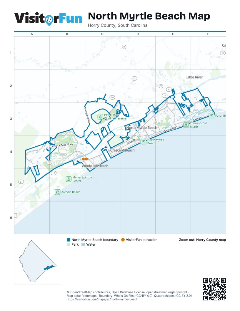
Street index of North Myrtle Beach
Each street on the sheet and the grid squares it crosses.
- Carolina Bays ParkwayC3, D3, A4, B4, C4, A5
- William H. Alford BridgeA4, B4, B5
- Veterans HighwayA4, B4
- Bobby C. King BridgeC3
- US Highway 17 SouthD3, B4, C4, D4
- US Highway 17 NorthD3, E3
- Robert Edge ParkwayC2, C3, D3
- US Highway 17E2, E3
- North Kings HighwayB4
- North Ocean BoulevardE3, F3, D4
- South Ocean BoulevardC4, D4, C5
- Sea Mountain HighwayE2, E3
- Main StreetD3, D4
- Old Highway 17E3
- 27th Avenue SouthC4
- Highway 90C2
- SC 90C2
- Water Tower RoadB3, A4, B4
- Club Course DriveB3, B4
- Champions BoulevardC2, C3
- Hillside Drive SouthC4, D4
- Little River Neck RoadE2, F2, E3, F3
- Barefoot Resort Bridge RoadB4, C4
- 11th Avenue NorthD3, E3
- 6th Avenue SouthD3, D4
- Hillside Drive NorthD3, E3, D4
- Marsh Glen DriveB4
- Duffy StreetE3
- 17th Avenue SouthC4, D4
- 33rd Avenue SouthC4
- 48th Avenue SouthB4, C4, C5
- 46th Avenue SouthC4
- Hill StreetE3
- 37th Avenue SouthC4
- Spring StreetE3
- Windy Hill RoadC4
- Barefoot Resort Bridge DriveB4
- Barefoot Swing BridgeB4, C4
- 39th Avenue NorthE3
- Old Sanders DriveD3
- Par AvenueB4
- Long Bay RoadB3, C3, B4, C4
- Perrin DriveC4, D4
- Water Lilly RoadC3
- Henry RoadA4, A5
- Spinnaker DriveF2, F3
- Madison DriveC4, D4
- Havens DriveC4, D4
- Edge DriveC4, D4
- Long Branch LoopA4
- Nixon StreetE3, F3
- Gray Heron DriveB4, C4
- Holly DriveC4, D4
- Bourne TrailC3
- 24th Avenue NorthE2, E3
- Lake DriveE3, F3
- 2nd Avenue SouthD3, D4
- Grande Dunes North Village BoulevardA4, A5
- 2nd Avenue NorthD3, D4
- 8th Avenue NorthD3, E3
- Copper Creek LoopA4, A5
- Seaview StreetC4, C5
- Oyster Catcher DriveB4
- 1st Avenue SouthD3, D4
- Bucks Bluff DriveE3, F3
- Windy Hill Road ExtensionC4
- Sandler BoulevardC3
- Belle DriveD3, D4
- Ye Olde Kings HighwayD3, E3
- Poinsett StreetC4
- Citizens CircleC3
- North Beach BoulevardB4, C4, C5
- Waterway DriveD3, E3
- Seabrook Plantation WayE3
- 9th Avenue SouthD3, D4
- Golf View DriveE3
- Bay StreetD3
- 27th Avenue NorthE2, E3
- James Island AvenueE3
- Catalina DriveB4
- 26th Avenue NorthE2, E3
- 25th Avenue NorthE2, E3
- 20th Avenue NorthE3
- 5th Avenue SouthD3, D4
- Thomas AvenueD3, D4
- Anne StreetD3
- Tidewater DriveF2, F3
- Cenith DriveD4
- Magnolia DriveE2, E3
- Seaside DriveE3
- Lorenzo DriveD3
- South Island DriveE2
- 23rd Avenue NorthE3
- Cypress BendB4
- Strand AvenueD4
- Leatherleaf DriveB4
- Seahope WayD3, E3
- 28th Avenue SouthC4
- Wiley DriveC4
- Seagull BoulevardE3
- Fox Hollow WayE3
- Firetower RoadD3
- Via Palma DriveB4
- 3rd Avenue SouthD3, D4
- Airport BoulevardC4
- 7th Avenue SouthD3, D4
- Park Pointe DriveC3
- Coates RoadC3
- Inlet View DriveF2, F3
- 21st Avenue NorthE3
- Harbor DriveF2
- Dunes StreetC4
- Surf Pointe DriveE3
- Morrall DriveF2, F3
- 13th Avenue NorthD3, E3
- 24th Avenue SouthC4
- Lake Egret DriveE3
- Pine Valley RoadE2, F3
- Shorehaven DriveE3
- 41st Avenue SouthC4
- Bridge View CourtB4
- 22nd Avenue NorthE3
- Springland DriveE3
- Vera WayA5
- 39th Avenue SouthC4
- 13th Avenue SouthD4
- Prince William RoadE3
- Heshbon DriveF2, F3
- Bentbill CourtB4
- Marina Bay DriveD3
- 11th Avenue SouthD4
- Ffa Circle RoadF2, F3
- Shadow Moss PlaceE3
- Surf StreetC4
- 43rd Avenue SouthC4
- Woodland StreetC4
- Weatherwood DriveB3
- Pete Dye DriveB4
- Hazel WayA5
- Wren AvenueB4
- Winding River DriveB4
- Premier Resorts BoulevardB4
- 34th Avenue SouthC4
- Rowyn StreetA4, A5
- Grand Meadow DriveA4, A5
- Tarpon Pond RoadE3
- 25th Avenue SouthC4
- Coquina DriveE2
- 16th Avenue SouthD4
- 14th Avenue SouthD4
- 15th Avenue SouthD4
- 4th Avenue SouthD3, D4
- 18th Avenue SouthC4, D4
- Ridgewood DriveD3
- 21st Avenue SouthC4
- Ashley LoopD3
- East Island DriveE3
- Forest DriveC4
- Park StreetE3
- Tidewatch WayB4
- Harbour Pointe DriveB4
- Church View RoadE3
- Dietra LaneD3
- 53rd Avenue NorthF3
- Lighthouse DriveE2, F2
- Surf Estates WayE3
- Jacks Circle RoadF2
- Cottage Cove CircleE3
- 45th Avenue SouthC4
- Peter Horry RoadC3
- Lewis StreetC4
- On Deck CircleC3
- Rosemary LaneD3
- Arbor CoveB4
- Sea Island WayD3, E3
- Thorny Oyster WayB4
- Terminal StreetC4
- 20th Avenue SouthC4
- North Cove CourtE3
- 23rd Avenue SouthC4
- Clipper DriveF2
- Eagle AvenueB4
- Everlee LaneA4, A5
- Possum Trot RoadD4
- Water StreetD3
- Olde Mill DriveC4
- Pheasant DriveB4
- 12th Avenue SouthD4
- Baron LaneD3
- Victoria Falls DriveE2, F3
- South Oak DriveD3, D4
- Clipper RoadF2
- Hedrick StreetC4
- Parkway DriveD3
- Elm StreetD3
- Captain Hook's WayE3
- Links DriveB3, D3
- Waterside StreetD3
- 19th Avenue SouthC4
- 38th Avenue SouthC4
- Ridge StreetE3
- West Port DriveD3
- 33rd Avenue NorthE3
- Goalkeeper DriveC3
- Oak Marsh LaneF2, F3
- 34th Avenue NorthE3
- Rip Tide CircleD3
- Pinecrest StreetC4
- Banyan PlaceC4
- Eyerly StreetC4
- Chestnut StreetE3
- 29th Avenue NorthE3
- Windy Heights RoadC4
- Gayle StreetD3
- Ocean Creek DriveB4
- Jolly Roger DriveE3
- Royal Oak CircleE2
- Tillson RoadD3, E3
- River Cross RoadB4
- Sea Coral WayB4
- 30th Avenue NorthE3
- Diamond Stars WayC3
- 56th Avenue NorthF3
- Frinks CourtF3
- 36th Avenue SouthC4
- 54th Avenue NorthF3
- Blossom StreetE3
- 52nd Avenue NorthF3
- 55th Avenue NorthF3
- Salt Creek CourtC4, C5
- Shell Creek CircleD3, D4
- 57th Avenue NorthF3
- 28th Avenue NorthE3
- 58th Avenue NorthF3
- Kingsport RoadE2
- Elizabeth StreetD3
- Hilton DriveC4
- Outrigger RoadD4
- Telephone RoadA4
- King StreetE3
- Brigantine RoadE2, F2
- Ocean Oaks BoulevardD4
- 26th Avenue SouthC4
- St Charles RoadE3
- Hunt Club RoadA4
- 22nd Avenue SouthC4
- 59th Avenue NorthF3
- Crosswinds AvenueE3
- Swan Lake DriveD3
- 40th Avenue SouthC4
- Futch StreetE3
- Lowe DriveE3
- Sunset Harbour WayE3
- Basin StreetE2
- Broome TerraceE2
- Bronwyn CircleD3, D4
- Moss StreetE3
- 51st Avenue NorthF3
- Captains LaneD3
- Sanderling DriveB4, C4
- Bellamy RoadD3, E3
- 1st Avenue NorthD3, D4
- 46th Avenue NorthF3
- Landing RoadD3
- Wayne StreetE3
- Starwatch DriveE3
- Doubloon DriveE3
- Mary Read DriveE3
- Colony DriveE3
- Hunter Rest DriveE3
- Bliss DriveA5
- 50th Avenue NorthF3
- Holloway Circle NorthE3
- Jordan RoadD3, E3
- 10th Avenue SouthD4
- Holloway Circle SouthE3
- 31st Avenue NorthE3
- Bonnet DriveE3
- Guyton DriveC3
- BirchwoodC4
- Merrill PlaceE3
- Sea Vista LaneD3
- 45th Avenue NorthF3
- Barry StreetE3
- Cedar AvenueD3
- 18th Avenue NorthE3
- Ashland AvenueD3
- Marion CircleC4
- 16th Avenue NorthE3
- 47th Avenue NorthF3
- 32nd Avenue NorthE3
- Blue Ridge TrailC4
- Townsend RoadD3, E3
- Seafarer WayD3
- Copper Meadow LoopA4, A5
- Pelican StreetE3
- Ameron CourtE3
- Grand Harbor BoulevardE2
- Harbour View LaneD3
- Graybill LaneE3
Things to do on the North Myrtle Beach map
Places on the map
- Abercrombie & Fish
- Action Water Sportz
- Airport Lagoon
- ALDI
- Alligator Adventure
- Anderson Brothers Bank
- Arby's
- Avista Resort
- Barefoot Landing
- Barefoot Marina
- Barefoot RV Resort
- Briarcliffe RV Resort
- Central Park
- Cherry Grove Beach
- Cherry Grove Inlet
- Cherry Grove Park
- Coastal North Shopping Center
- Crescent Beach
- FedEx Office
- Gator Hole Plaza
- Ingram Beach
- Ingram Dunes Nature Preserve
- Intracoastal Waterway
- Lewis Pond
- Love Course
- Lowe's
- McLean Park
- Norman Course
- North Myrtle Beach RV Resort
- North Myrtle Beach Sports Complex
- Ocean Drive Elementary School
- Southeastern Memorial Gardens
- Surf Golf & Beach Club
- The UPS Store
- Tidewater Golf Club
- Walmart Supercenter
- Windy Hill Beach
Next to North Myrtle Beach
- Atlantic Beach
- Briarcliffe Acres
- Little River
© OpenStreetMap contributors, Open Database License, openstreetmap.org/copyright · Map data: Protomaps · Boundary: Who's On First (CC-BY 4.0); Quattroshapes (CC BY 2.0)















