

South Carolina map
York County map
About 303,001 people live here (Census Bureau, 2024 estimate). The sheet's index lists 116 streets; State Highway 97, Charlotte Highway and Old York Road cross the most grid squares. Things to do inside the boundary: Kings Mountain National Military Park.
Open the map (PDF, US Letter)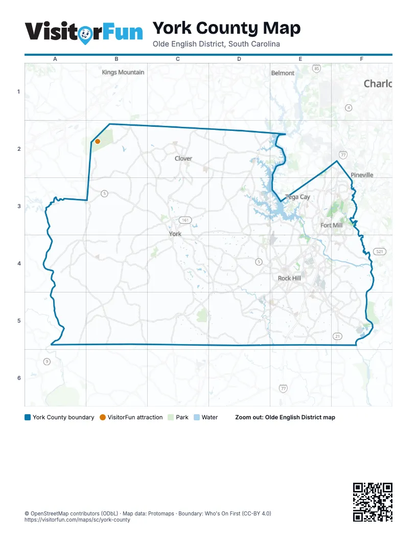
Street index of York County
Each street on the sheet and the grid squares it crosses.
- Highway 161 NorthB2
- Highway 161 SouthB2, C2, C3
- Highway 55 WestB2, C2, B3
- York RoadB2
- Bethel StreetC2
- Filbert HighwayC2, C3
- Highway 55 EastC2, D2
- Kings Mountain StreetC2, C3
- Main Street NorthC2
- Main Street SouthC2
- North Main Street EastC2
- North Main Street WestC2
- South Main Street EastC2
- South Main Street WestC2
- State Highway 557C2, D2
- York HighwayC2, C4, D4
- Charlotte HighwayD2, E2, C3, D3
- Hands Mill HighwayD2, D3, D4
- Pole Branch RoadD2, E2
- State Highway 274D2
- State Highway 55 EastD2
- Union RoadD2
- Pleasant RoadE2, F2, E3
- B. Bayles Mack HighwayF2
- Carowinds BoulevardF2
- Highway 21F2, F3, E4
- Highway 51F2
- Main StreetA3, B3, F3
- North Main StreetA3, B3
- State Highway 97A3, B3, A4, B4, B5
- Black HighwayB3, C3
- Clover HighwayB3
- East Main StreetB3, E4
- Kings Creek DriveB3
- South Main StreetB3
- Alexander Love HighwayC3, C4
- East Liberty StreetC3, C4
- Highway 161C3
- Highway 321 BypassC3, C4
- North Congress StreetC3
- Old York RoadC3, D3, C4, D4
- South Congress StreetC3, C4
- West Liberty StreetC3
- Clebourne StreetE3, F3
- Fort Mill ParkwayE3, F3, E4, F4
- Gold Hill RoadE3
- Highway 160 WestE3
- Highway 21 Bypass NorthE3, F3
- Highway 21 Bypass SouthE3, E4
- North Sutton RoadE3
- North White StreetE3, F3
- Old Nation RoadE3, F3
- SC 160E3
- South Sutton RoadE3, E4
- Spratt StreetE3, F3, E4
- Springfield ParkwayE3, F3
- Tega Cay DriveE3
- East Hensley RoadF3
- South White StreetF3
- State Highway 160F3
- Steele StreetF3
- Tom Hall StreetF3
- Hickory Grove RoadA4, B4
- Hopewell RoadA4
- Irene Bridge HighwayA4
- Smithford RoadA4
- Wylie AvenueA4, B4
- Lockhart HighwayB4
- Lockhart RoadB4, A5, B5
- Rainey AvenueB4
- Sharon RoadB4, C4
- York StreetB4
- Bratton AvenueC4
- Chester HighwayC4, C5
- Congress Street SouthC4
- E Liberty StC4
- Liberty Street EastC4
- McFarland RoadC4, D4
- Celanese RoadD4, E4
- Eastview RoadD4
- Gordon RoadD4
- Heckle BoulevardD4, E4
- Highway 324D4, D5
- McConnells HighwayD4, E4, C5, D5
- West Main StreetD4, E4
- Albright RoadE4, E5
- Celriver RoadE4
- Dave Lyle BoulevardE4
- East Black StreetE4
- East Friedheim RoadE4
- East Springdale RoadE4
- Ebenezer RoadE4
- Friedheim RoadE4
- Johnston StreetE4
- Main Street EastE4
- North Anderson RoadE4
- North Cherry RoadE4
- Oakland AvenueE4
- Ogden RoadE4
- Red River RoadE4
- Saluda StreetE4, E5
- South Anderson RoadE4, E5, F5
- South Cherry RoadE4
- South Dave Lyle BoulevardE4
- South Heckle BoulevardE4, E5
- South Oakland AvenueE4
- Springdale RoadE4
- State Highway 901E4
- West Black StreetE4
- West Oakland AvenueE4
- West McConnells HighwayA5, B5, C5
- Church StreetC5
- Saluda RoadD5, E5
- Mount Holly RoadE5
- Anderson Road SouthF5
- Catawba River RoadF5
Things to do on the York County map
Places on the map
- Adams Lake
- Airport Industrial Park
- Amber Woods
- Anne Springs Close Greenway
- Anniston Chase
- Antrim Business Park
- Apple Blossom Road
- Arden Mill
- Ashebrook Villas
- Ashford on the Water
- Ayrshire
- Baxter Close YMCA
- Baxter Town Center
- Beckett Farms
- Bethelfields
- Bexley
- Birkshire Heights
- Brayden
- Brittany Meadows
- Brooksmill
- Brookstone Apartment Homes
- Bryson Creek
- Burkette Lake
- Calliewood
- Calloway
- Cameron Creek
- Camp Canaan
- Camp Thunderbird
- Carolina Orchards
- Carowinds
- Carowood
- Cascades
- Catawba Nation
- Catawba Nuclear Station
- Catawba Park
- Catawba Ridge High School
- Century Springfield Meadows
- Chadwyck
- Charlotte / Fort Mill KOA
- Cherry Park
Next to York County
- Belmont
- Charlotte
- Kings Mountain
- Pineville
© OpenStreetMap contributors (ODbL) · Map data: Protomaps · Boundary: Who's On First (CC-BY 4.0)