

South Dakota map
Brookings map
About 24,555 people live here (Census Bureau, 2024 estimate). The sheet's index lists 300 streets; 6th Street, Main Avenue South and 22nd Avenue South cross the most grid squares. Things to do inside the boundary: Children's Museum of South Dakota.
Open the map (PDF, US Letter)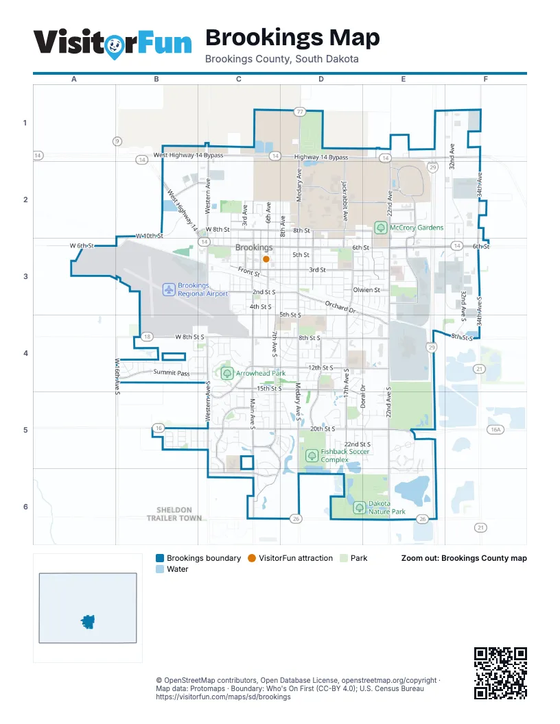
Street index of Brookings
Each street on the sheet and the grid squares it crosses.
- 6th StreetC3, D3, E3, F3
- West Highway 14B2, C2, C3
- Highway 14 BypassC1, D1, E1
- West Highway 14 BypassB1, C1
- West 6th StreetA3, B3, C3
- US Highway 14 BypassE1, F1
- 18th StreetE1, F1
- Main Avenue SouthC3, C4, C5, C6
- 22nd Avenue SouthE3, E4, E5, E6
- Medary Avenue SouthD3, D4, D5, D6
- 34th AvenueF1, F2, F3
- Medary AvenueD1, D2, D3
- 20th Street SouthC5, D5, E5
- 8th Street SouthC4, D4, E4, F4
- 22nd AvenueE1, E2, E3
- Main AvenueC2, C3
- 34th Avenue SouthF3, F4
- 32nd Street SouthE6
- 17th Avenue SouthD3, D4, D5
- Western AvenueC1, C2, C3
- 3rd StreetC3, D3, E3
- 8th StreetC2, D2, E2
- 7th Avenue SouthC3, C4, C5
- 12th Street SouthC4, D4, E4
- 15th Street SouthC4, D4, D5, E5
- West 8th Street SouthB4, C4
- Research Park WayE2
- Sweetgrass DriveC5, D5, C6
- Western Avenue SouthC3, C4, C5
- Orchard DriveD3, E4
- Jackrabbit AvenueD1, D2, D3
- Christine AvenueD4, D5
- Summit PassB4, C4
- West 20th Street SouthB5, C5
- 25th AvenueE1, E2, E3
- 6th AvenueC2, C3
- 2nd Street SouthC3, D3
- 9th StreetC2, D2, E2
- University BoulevardD2, E2
- 20th AvenueE1, E2, E3
- Trail Ridge RoadC4, C5
- West 16th Avenue SouthB3, B4
- 6th Avenue SouthC3, C4
- Sunrise Ridge RoadE2, E3
- 3rd AvenueC2, C3
- Larkspur Ridge DriveC5, C6
- North Campus DriveD2
- Olwien StreetD3, E3
- 5th AvenueC2, C3
- Half Moon RoadC5
- Front StreetC3
- West 13th StreetB2, C2
- 12th AvenueD2, D3
- 17th AvenueD3
- West 8th StreetB2, C2
- Eastbrook DriveE3
- Tallgrass ParkwayC5
- 10th StreetE2
- Swallow RidgeC6
- 26th Street SouthC6
- West 26th Street SouthC6
- West 2nd Street SouthC3
- 12th Avenue SouthD3
- Sunrise Ridge Road SouthE3
- Mustang PassC4
- Miller Park WayE2
- 32nd AvenueF1, F2, F3
- 5th Street SouthC3, D3, D4
- 7th StreetC2, C3, D3
- 5th StreetC3, D3
- 4th StreetC3, D3
- 1st StreetC3, D3, E3
- West 10th StreetB2, C2, B3
- 9th AvenueD2, D3
- 8th AvenueD2, D3
- 7th AvenueC2, C3
- 2nd StreetC3, D3
- Harvey Dunn StreetC2, D2
- Campanile AvenueD2, D3
- Steamboat TrailB4
- Indian Hills RoadC4
- 1st AvenueC2, C3
- 32nd Avenue SouthF3, F4
- Pheasant Run RoadD4
- Prince DriveF3
- 11th StreetC2, D2
- Derdall DriveD3, E3
- 3rd Street SouthC3, D3
- 11th AvenueD2, D3
- Moriarty DriveD5, E5
- Parkway BoulevardD4
- 5th Avenue SouthC3, C4
- 2nd AvenueC2, C3
- Elmwood DriveD3, E3
- LeFevre DriveF2, F3
- 14th AvenueD2, D3
- Regency CourtB4, C4
- Willow Branch AvenueD5, D6
- Crystal Ridge RoadC4
- West Wye MesaE5
- 1st Street SouthC3
- Goldenrod TrailC5, D5
- Telluride LaneB4, C4
- Oak Branch AvenueD5, D6
- 13th AvenueD3
- Division AvenueC3
- 22nd Street SouthD5, E5
- Windermere WayD5
- Park AvenueE4
- 3rd Avenue SouthC3
- East Wye MesaE5
- Doral DriveE4, D5, E5
- Elm AvenueD3, D4
- Chaparral DriveE5, E6
- 16th Avenue SouthD3, D5
- Hunters Ridge RoadC5, D5
- Lucerne AvenueE5
- Stadium RoadD1, D2
- Western Estates RoadE5
- Candlewood LaneC4, D4
- Dean CourtC5, C6
- Southland LaneE4
- Minnesota DriveE3
- 4th Street SouthC3
- Forest StreetD3
- Dracys ParkwayE5, E6
- Yorkshire DriveE3
- 9th Avenue SouthD5
- Circle DriveC2
- Overlook Ridge RoadC5
- Morningside DriveD3, E3
- 23rd Street SouthD5, E5
- Doctor Martin Luther King Junior WayC3
- Santee TrailC5
- Breckenridge LaneD4
- Lincoln LaneD3, E3
- Yosemite LaneD4
- Ace AvenueE5
- Kestrel LaneC5, C6
- Technology DriveE2
- Arrowhead PassC4, D4
- State AvenueE3
- East Blue Bell DriveC5
- Pine Ridge RoadC4, C5
- River Run RoadB5
- West 7th StreetC2
- Morning Glory DriveC5
- Heritage DriveD4
- Lincoln Lane SouthE3
- West Railroad StreetC3
- Pinehurst DriveE5
- 10th Street SouthD4
- Victory StreetD4, E4
- Folsom StreetC3
- Copper Mountain RoadC4
- Constitution BoulevardE5
- Bluegill AvenueD5
- 21st AvenueE3
- Southview DriveD3, D4
- Faculty DriveD3
- Rapid Valley StreetB5
- Grand Arbor AvenueD5
- King Arthur CourtD4
- Westminster DriveD4
- Yorktown DriveD4
- Thunder PassC4
- 21st Avenue SouthE3
- Pamela DriveD4
- Torrey Pines DriveD4, E4
- Sioux TrailC4, C5
- Broken Bow TrailC4
- Innovation DriveE2
- 8th Avenue SouthD3
- Teresa AvenueB5
- Chokecherry LaneC5, D5
- Rhonda RoadB5
- Morgans RunE5, E6
- Primrose DriveC5
- Squire CourtD4
- Camelot DriveD4
- Oriole TrailC5
- Wood Duck TrailC6
- Wagon Wheel CircleE5
- Rio Grande AvenueB5
- Legeros DriveD3
- Onaka TrailC4
- Round Up CircleE5
- Wilbert CourtE2
- Rapid Valley AvenueB5
- Eberlein DriveC5
- Calumet RoadC5
- Daktronics DriveF3
- State StreetE3
- Capital StreetF2
- 1st Avenue SouthC3
- Henry AvenueC2, C3
- Cardinal DriveC5
- Martin BoulevardB5, C5
- Canasta LaneE5
- Pebble Beach DriveD5
- 11th Street SouthD4
- Wilson AvenueC2, C3
- College AvenueD2
- Franklin AvenueE4, E5
- Spyglass Hill DriveD5, E5
- Student Union LaneD2
- Brighton RoadB4
- Cumberland CourtB5
- Sawgrass DriveD4
- 19th Street SouthC5, D5
- 24th Street SouthD5
- Wood Duck CircleC5, C6
- David CoveC5
- 2nd Avenue SouthC3
- 15th AvenueD3
- 16th AvenueD3
- Drop-Off LaneD4
- Dakota TrailC4
- Colonial VillageD3
- 18th Avenue SouthD3
- Sunrise Ridge CircleE3
- Ash AvenueD3, D4
- Dakota StreetD3, E3
- Fox Run TrailC5
- Powderhorn PassB4, C4
- Windsor DriveD4
- Brooklawn DriveD4
- Dakota AvenueE3
- Buffalo TrailC5
- Insbrook LaneE3, E4
- Santee PassC5
- Tanbury LaneD5
- Crystal Ridge CircleC4
- Pasqueflower PlaceE3, F3
- Yellowstone DriveD4
- Vine StreetD3
- Ohio DriveD3, E3
- Sunflower RoadC5, D5
- Craig CourtC5, C6
- LED DriveF3
- Saint Justice StreetD5
- Council Ridge RoadC5
- Avalon CircleD5, D6
- 14th Avenue SouthD3
- Crested Butte AvenueB4
- Wisconsin StreetD3
- Blue Bell DriveC5
- Kidoodle WayC3
- Birch AvenueD3
- Deer LaneC4
- Roberts AvenueD4
- Castlewood DriveD4
- Cypress Point DriveD5
- Remington DriveC5
- Eagle AvenueB4
- Kansas DriveE3
- Keystone CircleB4
- Sunnybrook DriveE1
- Vail AvenueB4
- Cedar AvenueD3
- Eastern AvenueE3
- Pactola CoveD4
- 7th Avenue WestB2
- Gilley Avenue SouthD3
- Jefferson Avenue SouthD3, E3
- Spring StreetD5
- Overlook Trail Ridge RoadC5
- West 4th StreetC3
- 16th Avenue WestB3
- Iowa StreetE3
- Slip Up RoadE6
- Durango PassB4
- Deer PassC5
- Blue Bell CircleC5
- Prairie View DriveD4
- Wahpeton PassC4
- Copper Mountain CircleB4, C4
- Horse Shoe BendE5
- Cloverfield PlaceC5
- Morgans PassE6
- Terrace Drive SouthD4
- Arapahoe LaneB4
- Castle Rock CircleB4
- Hammond AvenueD4
- Horner AvenueD4
- Swallow Ridge CircleC6
- Sylvan CircleD4, D5
- Fallbrook DriveF3
- Hughes AvenueC2, C3
- 17th Street SouthC5, D5
- Jefferson AvenueD3
- Yorktown CircleD4
- Christine CircleD5
- Century CircleF2
- Sioux PassC5
- Tatanka PassC5
- Jordan StreetB5
- Carter StreetB5
- Finch CircleC5
- Marian AvenueE3
Things to do on the Brookings map
Places on the map
- 50 meter pool
- 5th Street Gym
- 9-Hole Short/Executive Course
- Advance Auto Parts
- Aldi
- Arrowhead Park
- Automotive Service Center
- Brooking Municipal Utilitys
- Brookings Health System
- Brookings High School
- Brookings Municipal Utilities
- Brookings Post Office
- Brookings Regional Airport
- Brookings University Residential Historic District
- Calvary Cemetery
- Camelot Intermediate School
- Dakota Nature Park
- Dakota Prairie Park
- Douglas Chittick Community Gardens
- Eastside Commons
- EdgeBrook Golf Course
- Fishback Soccer Complex
- Greenwood Cemetery
- Hillcrest Elementary School
- Larson Park & Disc Golf Course
- Lowes
- McCrory Gardens
- Medary Park
- Mickelson Park
- Moriarty Park
- Pioneer Park
- SDSU Disc Golf Course
- Sexauer Park & Campground
- Southbrook Softball Fields
- The UPS Store
- University Marketplace
- Walmart Supercenter
Next to Brookings
- Sheldon Trailer Town
© OpenStreetMap contributors, Open Database License, openstreetmap.org/copyright · Map data: Protomaps · Boundary: Who's On First (CC-BY 4.0); U.S. Census Bureau















