

South Dakota map
Brookings County map
About 36,359 people live here (Census Bureau, 2024 estimate). The sheet's index lists 300 streets; US Highway 14, 200th Street and 483rd Avenue cross the most grid squares. Things to do inside the boundary: Brookings County Museum, Children's Museum of South Dakota and Oakwood Lakes State Park.
Open the map (PDF, US Letter)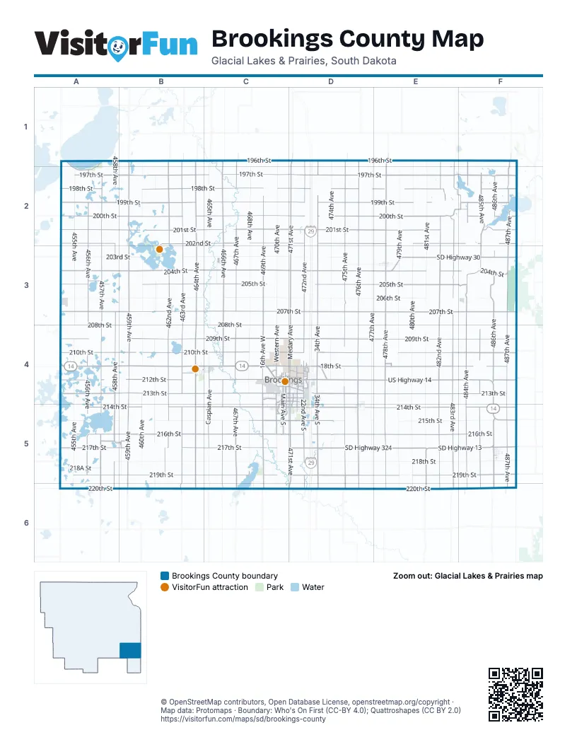
Maps inside Brookings County
2 maps inside, from the street map of Brookings County down.
City
Street index of Brookings County
Each street on the sheet and the grid squares it crosses.
- US Highway 14A4, B4, C4, D4, E4, F4, F5
- SD Highway 30D3, E3, F3
- US Highway 81A4, A5
- 6th StreetC4, D4
- West Highway 14B4, C4
- West 6th StreetB4, C4, F5
- 18th StreetD4
- US Highway 14 BypassD4
- West Highway 14 BypassC4
- Highway 14 BypassC4, D4
- East Highway 14B4, C4
- South Highway 81A4
- State Highway 19F3
- 476th AvenueD1, D2, D3, D4, D5, D6
- 214th StreetA5, B5, C5, D5, E5, F5
- 471st AvenueD1, D2, D3, D4, D5, D6
- 486th AvenueF2, F3, F4, C5, F5, F6
- 217th StreetA5, B5, C5, D5, F5
- 472nd AvenueD1, D2, D3, D4, D5, D6
- 212th StreetA4, B4, C4, F4
- SD Highway 13E5, F5, E6
- SD Highway 324D5, E5
- Medary AvenueD4
- 34th AvenueD4
- 22nd Avenue SouthD4, D5
- 20th Street SouthC5, D5
- 22nd AvenueD4
- Main Avenue SouthC4, C5
- 32nd Street SouthC5, D5
- Medary Avenue SouthD4, D5
- 34th Avenue SouthD4, D5
- 44th Street SouthC5, D5
- 8th Street SouthC4, D4
- Main AvenueC4, A5, B5
- West Redmond RoadD5
- North Broadway AvenueD4, D5
- South Broadway AvenueD5
- North Broadway Avenue / 476th AvenueD4
- County Road 13F4
- 207th StreetA3, B3, C3, D3, E3, F3
- 197th StreetA2, B2, C2, D2, E2, F2
- 219th StreetA5, B5, C5, D5, E5, F5
- 201st StreetA2, B2, C2, D2, E2, F2
- 199th StreetA2, B2, C2, D2, E2, F2
- 200th StreetA2, B2, C2, D2, E2, F2, F4
- 213th StreetA4, B4, C4, D4, E4, F4
- 210th StreetA4, B4, C4, D4, E4, F4
- 209th StreetA4, B4, C4, D4, E4, F4
- 204th StreetA3, B3, C3, D3, E3, F3
- 487th AvenueF1, F2, F3, F4, F5, F6
- 459th AvenueB1, B2, B3, B4, B5, B6
- 216th StreetA5, B5, C5, D5, E5, F5
- 202nd StreetA2, B2, C2, D2, E2, F2
- 205th StreetA3, B3, C3, D3, E3, F3
- 478th AvenueE1, E2, E3, E4, E5, E6
- 463rd AvenueB1, B2, B3, B4, B5, B6
- 464th AvenueB1, B2, B3, B4, B5, B6
- 482nd AvenueE1, E2, E3, E4, E5, E6
- 483rd AvenueE1, E2, F2, E3, E4, E5, E6
- 198th StreetA2, B2, C2, D2, E2, F2
- 466th AvenueC1, C2, C3, C4, C5, C6
- 457th AvenueA2, A3, A4, A5, A6
- 475th AvenueD1, D2, D3, D4, D5, D6
- 220th StreetA6, B6, C6, D6, E6, F6
- 196th StreetB1, C1, D1, E1, F1
- 462nd AvenueB1, B2, B3, B4, B5
- 484th AvenueF1, F2, F3, F4, F5, F6
- 467th AvenueC1, C2, C3, C4, C5, C6
- 485th AvenueF2, F3, F4, F5, F6
- 456th AvenueA2, A3, A4, A5
- 458th AvenueA1, A2, A3, A4, A5, A6
- 473rd AvenueD1, D2, D3, D4, D5, D6
- 469th AvenueC2, C3, C4, C5, C6
- 211th StreetA4, D4, E4, F4
- Caspian AvenueC4, C5
- Western AvenueC4
- West 20th Street SouthC5
- 16th Avenue WestC4
- West 16th Avenue SouthC4, C5
- Western Avenue SouthC4, C5
- South Lake DriveA1, A2
- West 42nd StreetC4
- 30th StreetC4, D4
- 42nd StreetC4, D4
- 488th Avenue / 100th AvenueF1, F2, F3
- West 32nd Street SouthC5
- West 8th Street SouthC4
- West 44th Street SouthC5
- 3rd StreetC3, B4, C4, D4, B5
- 17th Avenue SouthD4, D5
- 4th StreetC3, C4, D4, B5
- 8th StreetC4, D4
- 7th Avenue SouthC4, C5
- 12th Street SouthC4, D4
- 216A StreetA5, B5
- 15th Street SouthC4, D4
- Research Park WayD4
- Sweetgrass DriveC5
- Orchard DriveD4
- Jackrabbit AvenueD4
- 483B AvenueF2
- Christine AvenueD4, D5
- Summit PassC4
- Cornell AvenueF5
- 199A StreetE2, F2
- 25th AvenueD4
- 2nd Street SouthC4, D4, C5
- 6th AvenueC4
- Samara AvenueB4
- East North DriveF5
- 9th StreetC4, D4
- University BoulevardD4
- 20th AvenueD4
- Trail Ridge RoadC4
- 6th Avenue SouthC4
- Sunrise Ridge RoadD4
- 3rd AvenueC4
- West 8th StreetB4, C4, F5
- Larkspur Ridge DriveC5
- North Campus DriveD4
- Olwien StreetD4
- North Samara AvenueB4
- 5th AvenueC4
- Half Moon RoadC5
- Front StreetC4
- West 13th StreetC4
- 12th AvenueD4
- Main StreetE4
- 488th Avenue / County Highway 17F2
- 17th AvenueD4
- West North DriveF5
- Eastern AvenueD4, E4
- Eastbrook DriveD4
- Tallgrass ParkwayC5
- South Hooker AvenueE3
- North Cornell AvenueF5
- 10th StreetD4
- Swallow RidgeC5
- 26th Street SouthC5
- West 26th Street SouthC5
- West 2nd Street SouthC4
- 12th Avenue SouthD4
- North Hooker AvenueE3
- Sunrise Ridge Road SouthD4
- Mustang PassC4
- Miller Park WayD4
- County Road 14F2
- 110th StreetF5
- County Highway 17F2
- North Hooker Avenue / 478th AvenueE3
- 488th AvenueF1, F2
- County Road 10F5
- County Road 38C2
- 218th StreetA5, B5, C5, D5, E5, F5
- 206th StreetA3, B3, C3, D3, E3, F3
- 477th AvenueD1, D2, D3, D4, D5, D6
- 479th AvenueE1, E2, E3, E4, E5, E6
- 480th AvenueE1, E2, E3, E4, E5, E6
- 455th AvenueA2, A3, A4, A5, A6
- 481st AvenueE1, E2, E3, E4, E5
- 215th StreetA5, B5, C5, D5, E5, F5
- 203rd StreetA3, B3, C3, D3
- 470th AvenueC1, C2, C3, C4, C5, C6
- 460th AvenueB1, B2, B3, B4, B5
- 468th AvenueC2, C3, C4, C5
- 208th StreetA4, B4, C4, D4, E4, F4
- 474th AvenueD1, D2, D3, D4, D5
- 465th AvenueC1, A2, C2, C3, C4, C5, C6
- 461st AvenueB1, B2, B3, B4, B5
- 28th Avenue WestC4
- 46th AvenueD4
- 218A StreetA5
- 203A StreetD3, E3
- West 30th StreetC4
- 5th StreetC3, C4, D4
- Oakwood DriveB2, B3
- 458B AvenueB5
- 32nd AvenueD4
- 1st StreetC3, C4, D4, A5, F5
- 54th StreetC4, D4
- South 28th Avenue WestC4, C5
- 2nd StreetC3, C4, D4, B5
- East 5th StreetE3, B4, C4, F5
- West 5th StreetE3, B4, F5
- West 54th StreetC4
- 5th Street SouthC4, D4
- 7th StreetC4, D4
- East 4th StreetE3, B4, C4, F5
- East 6th StreetE3, B4, C4, F5
- West 10th StreetC4
- North Caspian AvenueC4
- 212A StreetA4
- 461 AvenueB5, B6
- 465B AvenueC3
- 58th AvenueD4
- County Road 28E5
- Ramlo Shores DriveF2
- East 2nd StreetE3, B4, F5
- Elk StreetF5
- 9th AvenueD4
- East 1st StreetE3, B4, C4
- 8th AvenueC4
- South Oakwood Shoreline DriveB3
- 7th AvenueC4
- Park AvenueD4, A5, B5
- Harvey Dunn StreetC4, D4
- Oakwood Park DriveB2, B3
- Kasan AvenueB4
- Danceland RoadC5, C6
- West 2nd StreetE3, B4, F5
- Campanile AvenueD4
- Lincoln LaneB4, D4
- Steamboat TrailC4
- West 4th StreetE3, B4, C4, F5
- East 3rd StreetB4, F5
- Buffalo StreetF5
- Elm AvenueB4, D4, D5
- Indian Hills RoadC4
- Astrachan AvenueB4
- Westview RoadC5, C6
- Sunset RoadC5
- 1st AvenueC4
- Lakeshore DriveC5
- Bortnem Beach RoadC5, C6
- 32nd Avenue SouthD4
- Pheasant Run RoadC4, D4
- Prince DriveD4
- 11th StreetC4, D4
- Sunnyview DriveD4
- Jay StreetC3
- West 7th StreetB4, C4, F5
- 3rd Avenue SouthC4, C5
- Derdall DriveD4
- 3rd Street SouthC4, D4
- Madison StreetC3, D5
- 2nd AvenueC3, C4
- 11th AvenueD4
- Antelope StreetF5
- Moriarty DriveD4, D5
- Jefferson AvenueC4, D4
- Parkway BoulevardD4
- Beaver StreetF5
- Dakota Shores PlaceF2
- West Lake Hendricks DriveF2
- East Main StreetE3
- East Rasmussen StreetD5
- 5th Avenue SouthC4
- Ag First PlaceD5
- Hansina AvenueB4
- Washington RoadB4, C4
- Elmwood DriveD4
- Spruce StreetD4
- Northshore DriveC5
- Lovejoy LaneD4
- Railway StreetC3
- West Main StreetE3
- Henry AvenueB4, C4
- East Pine StreetD5
- Clubhouse DriveC5
- LeFevre DriveD4
- 14th AvenueD4
- Regency CourtC4
- Wagner StreetC3
- Willow Branch AvenueD5
- Crystal Ridge RoadC4
- West Wye MesaD5
- Maple DriveC5
- Audra DriveD5
- Industrial DriveB4
- 1st Street SouthC4
- Goldenrod TrailC5, D5
- Marvin AvenueB4
- Telluride LaneC4
- Oak Branch AvenueD5
- 13th AvenueD4
- Division AvenueC4
- 22nd Street SouthD5
- Windermere WayD5
- East Warehouse StreetF5
- 1st Avenue SouthC4, E4
- County Highway 31A6
- Chaparral DriveD5
- 58th Avenue / 475th AvenueD4
- East Wye MesaD5
- Doral DriveD4, D5
- North Lake Hendricks DriveF2
- West 3rd StreetB4, F5
- 16th Avenue SouthD4, D5
- Hunters Ridge RoadC5
- Lucerne AvenueD5
- South Lake Hendricks DriveF2
- Stadium RoadD4
- North Grove LoopD3
- 36th Street SouthC5
- Washington StreetC3
- Brighton RoadC4, C5
- Western Estates RoadD5
- Twin Oaks LaneC5
- Candlewood LaneC4, D4
- Dean CourtC5
Things to do on the Brookings County map
Places on the map
- Afton Township
- Alton Township
- Argo Township
- Aurora
- Aurora Township
- Bangor Township
- Black Slough
- Brookings
- Brookings Country Club
- Brookings Landfill
- Brookings Regional Airport
- Brookings Township
- Bruce
- Bushnell
- Dakota Nature Park
- Elkton
- Elkton Township
- Eureka Township
- Lake Campbell
- Lake Hendricks Township
- Lake Oakwood
- Lake Poinsett Recreation Area
- Lake Sinai
- Lake Sinai Township
- Laketon Township
- Medary Township
- Moe Slough
- Mortimer Slough
- Oak Lake
- Oaklake Township
- Oakwood Lakes State Park
- Oakwood Township
- Oslo Township
- Parnell Township
- Preston Township
- Richland Township
- Sherman Township
- Sinai
- Sterling Township
- Trenton Township
© OpenStreetMap contributors, Open Database License, openstreetmap.org/copyright · Map data: Protomaps · Boundary: Who's On First (CC-BY 4.0); Quattroshapes (CC BY 2.0)















