

South Dakota map
Minnehaha County map
About 208,639 people live here (Census Bureau, 2024 estimate). The sheet's index lists 300 streets; 256th Street, 254th Street and 246th Street cross the most grid squares. Things to do inside the boundary: Falls Park, Great Plains Zoo and Old Courthouse Museum.
Open the map (PDF, US Letter)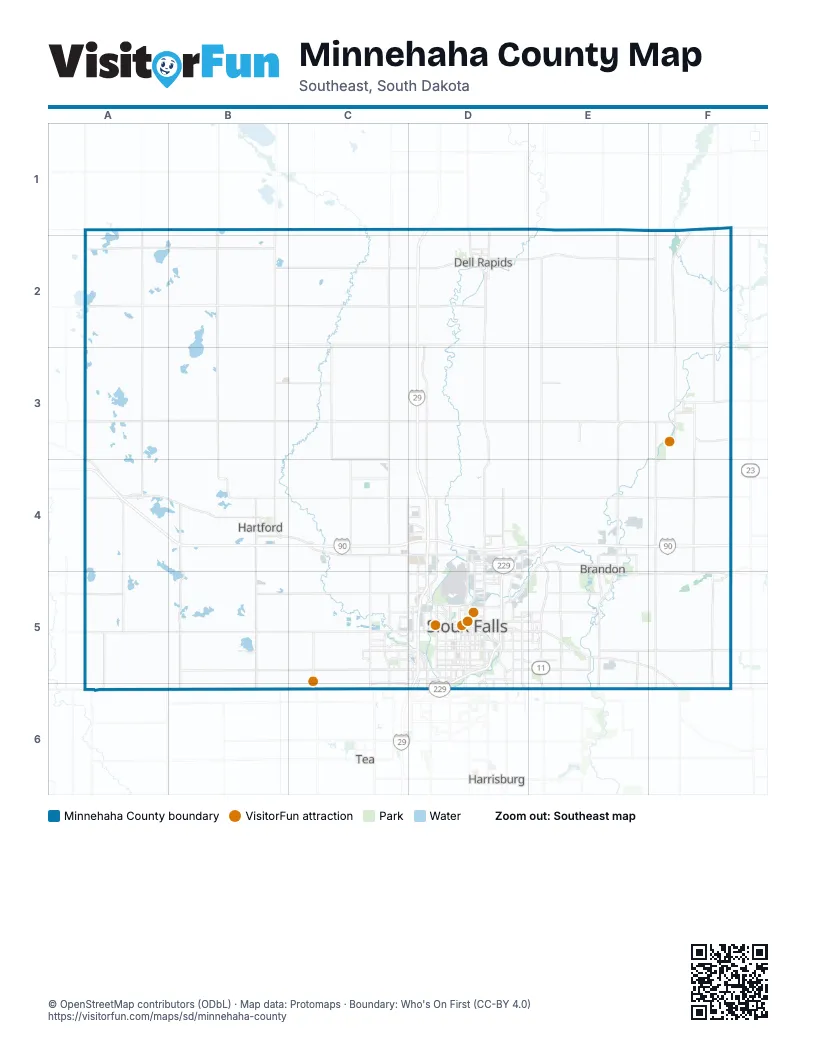
Maps inside Minnehaha County
1 map inside, from the street map of Minnehaha County down.
Street index of Minnehaha County
Each street on the sheet and the grid squares it crosses.
- North I-29D4, D5
- East I-90D4, E4
- North I-229D4, D5
- West I-90C4, D4
- South I-29D5, D6
- South I-229D5
- West I-229D5, D6
- East I-229D5
- 254th StreetA3, B3, C3, D3, E3, F3
- 246th StreetA2, B2, C2, D2, E2, F2
- 457th AvenueA1, A2, A3, A4, A5, A6
- 485th AvenueF1, F2, F3, F4, F5, F6
- 455th AvenueA2, A3, A4, A5, A6
- 265th StreetA5, B5, C5, E5, F5
- 456th AvenueA2, A3, A4, A5, A6
- 481st AvenueE1, E2, E3, E4, E5, E6
- 244th StreetA1, B1, C1, D1, E1, F1
- 482nd AvenueE1, E2, E3, E4, E5
- 475th AvenueD1, D2, D3, D4
- 268th StreetA6, B6, C6, E6
- North Veterans ParkwayE4, E5
- West 41st StreetC5, D5
- West Russell StreetD5
- North Cliff AvenueD4, D5
- West 12th StreetD2, B4, C5, D5
- East Arrowhead ParkwayD5, E5
- North Minnesota AvenueB2, D4, D5
- South Veterans ParkwayE5, E6
- West 26th StreetC5, D5
- East 10th StreetD2, D5, E5
- East Rice StreetE4, D5, E5
- SD Highway 42A5, E5, F5, F6
- West Benson RoadC5, D5
- East Benson RoadD5
- South Minnesota AvenueB2, D5, D6
- North West AvenueC4, D5
- South West AvenueC4, D5, D6
- West 10th StreetD2, C4, C5, D5
- South Splitrock BoulevardE4, E5
- South Louise AvenueD5, D6
- East 11th StreetD2, C4, D5
- West Holly BoulevardE4
- West 4th StreetB2, D2, B4, C4, D5
- South 2nd AvenueE4, D5, E5
- Highland RoadF1, F2
- West 11th StreetC5, D5
- North Splitrock BoulevardE4
- East North StreetA4
- East Holly BoulevardE4
- North Ford StreetA4
- West North StreetA4
- River AvenueF3
- South Highway 115D2
- North Highway 115D2
- SD Highway 19A6
- East Highway 42E5
- South Highway 11E6
- 250th StreetA2, B2, C2, D2, E2, F2
- 258th StreetA4, B4, C4, D4, E4, F4
- 253rd StreetA3, B3, C3, D3, E3, F3
- 484th AvenueF1, F2, F3, F4, F5, F6
- 466th AvenueC1, C2, C3, C4, C5, C6
- 463rd AvenueB1, B2, B3, B4, B5, B6
- 486th AvenueF1, F2, F3, F4, F5, F6
- 266th StreetA5, B5, C5, E5, F5
- 476th AvenueD1, D2, D3, D4
- 478th AvenueE2, E3, E4
- 471st AvenueD1, C2, D2, C3, C4
- 262nd StreetA5, B5, C5, F5
- Jasper StreetD2, E2, F2
- SD Highway 38A3, A4, B4, C4
- West 60th Street NorthC4, D4
- North Marion RoadC4, D4, D5
- East 41st StreetD5, E5
- East 26th StreetD5, E5
- West Madison StreetC5, D5
- 474th AvenueD1, D2, D3
- East 6th StreetB2, D2, B4, C4, D5, E5
- North Kiwanis AvenueD4, D5
- South Ellis RoadC5, C6
- East 57th StreetE5, D6, E6
- East Madison StreetD5, E5
- West 57th StreetC6, D6
- East 60th Street NorthD4, E4
- West Maple StreetC5, D5
- South Western AvenueB4, D5, D6
- North Ellis RoadC4, C5
- East 18th StreetD5, E5
- South Six Mile RoadE5, E6
- South Cliff AvenueD5, D6
- North Six Mile RoadE4, E5
- East 4th StreetB2, D2, B4, C4, D5, E5
- North Western AvenueB4, D4, D5
- South Sycamore AvenueD5, D6
- West 49th StreetC5, D5
- South Marion RoadD5, D6
- East 8th StreetB2, D2, C4, D5
- East Redwood BoulevardE4
- South Sertoma AvenueC5, C6
- South Southeastern AvenueD5, D6
- East Aspen BoulevardE5, F5
- Highway 38A3, A4, C4
- South Kiwanis AvenueD5
- East 7th StreetB2, D2, C4, D5
- North 4th AvenueD4, D5
- North Westport AvenueD4, D5
- West Highway 38C4
- East 9th StreetD2, B4, C4, D5, E5
- West 6th StreetB2, B4, C4, C5, D5
- West 8th StreetD2, B4, C5, D5
- North Sycamore AvenueD4, D5
- South Sioux BoulevardE4, E5
- West 14th StreetD2, C5, D5
- East 14th StreetD2, D5
- North North DriveD5
- East River BoulevardD5
- Lovely AvenueD2
- Dows StreetF3
- East SD Highway 38B4
- North Jaycee LaneD5
- Garfield AvenueD2
- North Sioux BoulevardE4
- West Burnside StreetD5
- Oak DriveF3
- North Highway 77D2
- South Solberg AvenueD5, D6
- West SD Highway 38B4
- 191st StreetF2
- County Highway 4F5
- 161st StreetF3
- North Kiwanis Avenue / North Westport AvenueD4
- North Sioux Boulevard / South Sioux BoulevardE4
- 252nd StreetA3, B3, C3, D3, E3, F3
- 257th StreetA4, B4, C4, D4, E4, F4
- 248th StreetA2, B2, C2, D2, E2, F2
- 255th StreetA3, B3, C3, D3, E3, F3
- 256th StreetD3, F3, A4, B4, C4, D4, E4, F4
- 245th StreetA2, B2, C2, D2, E2, F2
- 459th AvenueB2, B3, B4, B5, B6
- 487th AvenueF1, F2, F3, F4, F5, F6
- 461st AvenueB1, B2, B3, B4, B5, B6
- 467th AvenueC2, C3, C4, C5, C6
- 267th StreetA5, B5, C5, E5, F5
- 464th AvenueB1, B2, B3, B4, B5, B6
- 263rd StreetA5, B5, C5, E5, F5
- 483rd AvenueE1, E2, E3, E4, E5, E6
- 468th AvenueC2, C3, C4, C5, C6
- 480th AvenueE1, E2, E3, E4
- 469th AvenueC2, C3, C4, C6
- 470th AvenueC1, C2, C3, C4
- 472nd AvenueD2, D3, D4
- 454th AvenueA2, A3, A4, A5, A6
- 477th AvenueD1, D2, E2, D3, D4
- North Career AvenueD4, D5
- East 3rd StreetB2, D2, B4, C4, D5, E5
- North La Mesa DriveC4, C5
- East 33rd StreetD5, E5
- South Main AvenueB2, F3, B4, E4, D5, E5
- East 15th StreetD2, D5, E5
- West 22nd StreetC5, D5
- West 9th StreetD2, C4, C5, D5
- East 2nd StreetB2, D2, B4, C4, D5
- North Bahnson AvenueD4, D5
- East Maple StreetD5, E5
- South Bahnson AvenueD5, D6
- West 15th StreetD2, C5, D5
- West 5th StreetB2, D2, B4, C4, C5, D5
- South Garfield AvenueD2, D5
- East 49th StreetD5, E5
- West 32nd StreetC5, D5
- North Main AvenueB2, F3, B4, D5
- West 37th StreetC5, D5
- South Duluth AvenueD5, D6
- West 3rd StreetD2, B4, C5, D5
- North Lewis AvenueD4, D5
- South Grange AvenueD5
- North Louise AvenueD4, D5
- East 12th StreetD2, B4, D5
- South Phillips AvenueD5
- East 38th StreetD5, E5
- South 4th AvenueE4, D5, E5
- West 53rd StreetC6, D6
- South Summit AvenueD5
- South Dakota AvenueB2, D5
- West 33rd StreetC5, D5
- West 18th StreetC5, D5
- South Lake AvenueD5
- West 51st StreetC5, D5, D6
- South 7th AvenueE4, D5, E5
- West Foundation CourtD4
- West 2nd StreetB2, D2, B4, D5
- South Prairie AvenueD5
- South Sherman AvenueB2, D5
- East 21st StreetD5, E5
- West 16th StreetC5, D5
- South Norton AvenueD5
- East 72nd Street NorthD4
- Centennial PlaceD2
- East 54th Street NorthD4
- East 1st StreetB2, D2, B4, D5
- South Valley View RoadC5
- North Phillips AvenueD5
- West 1st StreetB2, D2, B4, D5
- 5th StreetD2, C3, D3, F3
- South Cleveland AvenueD5
- East 20th StreetD5
- South Blauvelt AvenueD5
- West Stoney Creek StreetC5
- 4th StreetD2, C3, D3, F3
- East 23rd StreetD5, E5
- East Mickelson RoadB4
- East 17th StreetD5, E5
- West Brookings StreetD5
- West Mickelson RoadB4
- South Foss AvenueE5
- North Cleveland AvenueD5
- East 36th StreetD5, E5
- North Dakota AvenueB2, D5
- South Ebenezer AvenueD5
- North Prairie AvenueD5
- West 84th Street NorthD4
- North Valley View RoadC5
- South Highline AvenueE5
- North Terry AvenueD5
- Scotts AvenueB4
- Cliff AvenueF5
- North Colton RoadB4
- North Weber AvenueD5
- East 35th StreetD5, E5
- Broadway AvenueF5
- West Silver Valley DriveC5, D5
- North Lowell AvenueD5
- North Potsdam AvenueD4, D5
- Valley DriveF5
- South Chestnut BoulevardE4, E5
- East 34th Street NorthD5
- South Highline PlaceE5
- South Terry AvenueD5
- North Chestnut BoulevardE4
- South Lewis AvenueD5, D6
- North Dubuque AvenueE5
- Orleans AvenueD2
- South Shirley AvenueD5
- East 39th Street NorthD5
- Slip Up Creek RoadD4
- Clark AvenueD2
- North Lyon BoulevardD5
- North Seubert AvenueD4
- North Ebenezer AvenueD5
- South Riverview AvenueE5
- South Galway AvenueC5, C6
- South Lowell AvenueD5
- East Amidon StreetD5
- East Hermosa DriveD5
- North Blauvelt AvenueD5
- East Ash StreetE4, D5
- Dunham StreetF5
- North Fairfax AvenueD4, D5
- East 56th Street NorthD4
- South Westlake DriveD5
- West Lake Shore BoulevardD5
- West 2nd AvenueA4
- North Tahoe TrailE5
- West Park StreetE5
- East Split Rock RoadE5
- West Highway 130B4
- West Memory LaneC4, D4
- South Lorraine PlaceD5
- South Lyons AvenueD5
- South Yeager RoadD5
- East 2nd AvenueA4
- South Jessica AvenueD5
- Iowa AvenueD2
- North Franklin AvenueD5
- South Katie AvenueC5
- South Oxbow AvenueD5, D6
- North Sechser AvenueD4
- North Highline AvenueE5
- South Lorraine DriveD5
- South Grange DriveD5
- West Innovation StreetD5
- East Dogwood StreetE4
- East Tomar RoadD5, D6
- East Falls Park DriveD5
- South Main StreetA4
- South Fairfax AvenueD5
- Quartzite StreetD2
- East Dike DriveD4
- South Tomar RoadD6
- South La Mesa DriveC5
- North Foss AvenueE5
- East Chambers StreetD5
- South Lyon BoulevardD5
- 259th Street / West 84th Street NorthC4, D4
- 100th Street / 11th StreetF6
- South Snowberry TrailC5
- East Ash PlaceE4
- South River RoadD5
- South Franklin AvenueD5
- North Main StreetA4
Things to do on the Minnehaha County map
Places on the map
- All Saints
- All Saints Historic District
- Anderson
- Arrowhead Park
- Baltic
- Beaver Creek Nature Area
- Benton Township
- Big Sioux Recreation Area
- Boadwine Dairy
- Brandon
- Brandon Golf Course
- Brandon Township
- Buffalo Lake
- Buffalo Township
- Burk Township
- Central Valley Golf Club
- Cherry Rock Park
- Clear Lake Township
- Colton
- Country Club of Sioux Falls
- Crooks
- Crown Pointe
- Dell Rapids
- Dell Rapids East Quarry
- Dell Rapids Township
- Dell Rapids West Quarry
- Downtown
- Dunham Park
- East Sioux Quarry
- Edison Township
- Elmwood Golf Course
- Englehardt Slough
- Family Park
- Fensterman Slough
- Garfield
- Garretson
- Grand Meadow Township
- Grass Lake
- Great Bear Recreation Park
- Harmodon Park
Next to Minnehaha County
- Harrisburg
- Tea
© OpenStreetMap contributors, Open Database License, openstreetmap.org/copyright · Map data: Protomaps · Boundary: Who's On First (CC-BY 4.0); Quattroshapes (CC BY 2.0)