

Tennessee map
Chattanooga map
About 191,496 people live here (Census Bureau, 2024 estimate). The sheet's index lists 300 streets; Shallowford Road, Oak Street and Hixson Pike cross the most grid squares. Things to do inside the boundary: Chattanooga Ghost Tours, Escapology Chattanooga and Hamilton Place.
Open the map (PDF, US Letter)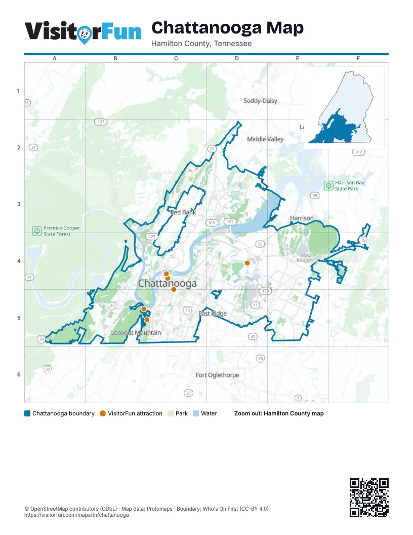
Street index of Chattanooga
Each street on the sheet and the grid squares it crosses.
- Dupont ParkwayD3, D4
- Wilkes T. Thrasher BridgeD3
- Hixson PikeD2, C3, D3, C4
- Lee HighwayE4, F4, D5, E5
- Bonny Oaks DriveD4, E4
- Highway 58E3, D4, E4
- Amnicola HighwayC4, D4
- Cummings HighwayB5, C5
- Riverside DriveC4, D4
- Broad StreetC4, C5
- Brainerd RoadD5
- Old Lee HighwayE4, F4
- Dodds AvenueC5
- McCallie AvenueC4, C5, D5
- Rossville BoulevardC5
- East Main StreetC5
- East 23rd StreetC5
- Birmingham HighwayB5
- East 4th StreetC4, C5
- Suck Creek RoadB3, C3
- Signal Mountain BoulevardB3, C3
- Signal Mountain RoadC3, C4
- Duncan AvenueC4, C5
- West Martin Luther King BoulevardC4
- West 20th StreetC5
- Bailey AvenueC5
- Manufacturers RoadC4
- Dayton PikeD2
- East Martin Luther King BoulevardC4, C5
- Westside DriveC5
- Barton AvenueC4
- Veterans BridgeC4
- Cherokee BoulevardC4
- East 20th StreetC5
- West Main StreetC4, C5
- Georgia AvenueC4
- Frazier AvenueC4
- Washington StreetC5
- West 4th StreetC4
- Dodds Avenue OverpassC5
- Bachman TunnelC5
- Mabel StreetC4
- Missionary Ridge TunnelD5
- Shallowford RoadD4, E4, C5, D5, E5
- Mountain Creek RoadC2, C3, C4
- East Brainerd RoadD5, E5
- Volkswagen DriveE4
- Jenkins RoadE4, E5
- Hickory Valley RoadE4, E5
- Central AvenueC4, D4, C5, D5
- Gunbarrel RoadE4, E5
- Dodson AvenueC4, D4, C5
- Wilcox BoulevardC4, D4
- Tunnel BoulevardD4, D5
- Riverfront ParkwayC4, C5
- East 3rd StreetC4, C5, D5
- Dayton BoulevardC2, D2, C3, C4
- Moccasin Bend RoadC4, B5, C5
- Lake Resort DriveD3
- Ochs HighwayB5, C5
- North Moore RoadD4, D5
- Tennessee AvenueC5
- Market StreetC4, C5
- South Market StreetC5
- Pineville RoadC4
- North Access RoadD3
- St. Elmo AvenueC5
- East 38th StreetC5
- 4th AvenueC5
- East 37th StreetC5
- North Holtzclaw AvenueC4, C5
- South Holtzclaw AvenueC5
- South Scenic HighwayB5
- Ashland TerraceC3
- Old Wauhatchie PikeB5, C5
- Alton Park BoulevardC5
- South Willow StreetC5
- Apison PikeE4, F4
- North Willow StreetC4, C5
- North Germantown RoadD5
- West 40th StreetC5
- Glass StreetD4
- West 38th StreetC5
- South Germantown RoadD5
- Carter StreetC4, C5
- Hamm RoadC4
- Stonedge PointB5
- Campbell StreetD4
- New York AvenueD4
- Main StreetE4, F4, C5
- West 12th StreetC4
- South Moore RoadD5
- South Kelley StreetC5
- Ochs Highway ExtensionB5
- Morrison SpringsC3
- Lindberg AvenueC5
- Probasco PlaceD5
- Stringers Ridge TunnelC4
- Hamill RoadD3
- South Crest RoadC5, D5
- Standifer Gap RoadE4
- North Crest RoadD4, D5
- Browntown RoadC2, D2, C3
- Browns Ferry RoadB4, B5
- Jersey PikeD4, E4
- Wauhatchie PikeB5
- Ferdinand Piëch WayE3, E4
- Elder Mountain RoadB4
- Claude Ramsey ParkwayE3, E4
- Igou Gap RoadE5
- Lightfoot Mill RoadD4
- Airport RoadD4, D5
- North Chamberlain AvenueC4, D4
- Gadd RoadC3, D3
- Grubb RoadD2, D3
- East 5th StreetC4, C5
- North Hawthorne StreetC4, D4, C5
- Kellys Ferry RoadB5
- Morris Hill RoadE5
- Old Hixson PikeD3
- Old Dayton PikeC2, D2, C3
- Ely RoadC3, D3
- North TerraceD5
- Norcross RoadC3, D3
- Ogrady DriveB4
- Mountain View RoadC3, F3, F4
- Roanoke AvenueC4, D4
- Chestnut StreetC4, C5
- Williams StreetC5
- Isbill RoadB4, B5
- Airport Connector RoadD4, D5
- Northpoint BoulevardD3
- South TerraceD5
- East 28th StreetC5
- South Hickory StreetC5
- Workman RoadC5
- Goodwin RoadE5
- Cassandra Smith RoadD3
- Lupton DriveC3
- Glenwood DriveD4, C5, D5
- Rogers RoadD5
- Graysville RoadE5
- Middle Valley RoadD2, D3, F4
- West 37th StreetC5
- 7th AvenueC5
- Eastgate LoopD5
- Saint Elmo AvenueC5
- Shepherd RoadD4, E4, D5
- South Seminole DriveC5, D5
- Oakwood DriveD4, E4
- Clio AvenueC5
- East 29th StreetC5
- Wilder StreetD4
- Mississippi AvenueC4
- Wilson RoadC5
- West Shepherd RoadD4, E4
- Lindsay StreetC4
- Houston StreetC4
- Discovery DriveE4
- Wisdom StreetC4, D4
- Delashmitt RoadC3
- Dallas RoadC4
- Long StreetC5
- Rossville AvenueC5
- West 33rd StreetC5
- Derby StreetC4, C5
- Belvoir AvenueD5
- Boy Scout RoadD2
- Spring Creek RoadD5
- Douglas StreetC4
- East 47th StreetC5
- Altamont RoadC4
- Thrushwood DriveC3
- Lee AvenueB4, C5
- Dowlen RoadD2
- Adkins RoadB5
- North Market StreetC4
- Courage WayE4
- Mc Brien RoadD5
- West 21st StreetC5
- Austin RoadD3
- Artesian CircleF4
- West 25th StreetC5
- West Boy Scout RoadD2
- West Mississippi AvenueC4
- Champion RoadE3
- School DriveD3, D4
- East Dallas RoadC4
- Old Dallas RoadC4
- West 3rd StreetC4
- John Ross RoadC5
- Snow Hill RoadF4
- Boydton RoadB4
- River StreetC4
- Hunter RoadF4
- Ooltewah Georgetown RoadF4
- Mitchell Mill RoadF4
- W RoadC3
- South Chickamauga Creek GreenwayD4
- Miller StreetD5
- West Aquarium WayC4
- Mackey Branch DriveE5
- Clark RoadE3
- East Shadowlawn DriveC5
- North Aster AvenueB5
- Memorial DriveC4
- Easton AvenueC3
- Elementary WayF4
- Front RoadE5
- North Hickory Valley RoadE3
- Still Hollow LoopE3, F3, E4, F4
- River Gorge DriveA5, B5
- Fairview RoadD2, D3
- Gann Store RoadD3
- Big Ridge RoadD3
- Lower Mill RoadD2, D3
- Oak StreetC4, D4, B5, C5, D5
- Whitehall RoadC4
- North Orchard Knob AvenueC4, D4, C5
- Harrison PikeD4
- North Concord RoadE4, E5
- Webb RoadD3, E3, D4, E4
- Crestview DriveC2, D2, C3
- Talley RoadD4, D5
- Wheeler AvenueC4, D4
- South Orchard Knob AvenueC5
- 13th AvenueC5
- 12th AvenueC5
- East 17th StreetC5
- Taylor StreetC4, D4
- East 14th StreetC5
- East 12th StreetC4, C5
- East 13th StreetC5
- Calhoun AvenueC5
- Greenwood RoadD4
- Kings RoadD4
- Cummings RoadB5
- Runyan DriveC3, C4
- Alabama AvenueC5
- 15th AvenueC5
- Montview DriveD5
- Vine StreetC4, C5
- Airport Perimeter RoadD5
- East 32nd StreetC5
- 14th AvenueC5
- East 19th StreetC5
- Hancock RoadD4, E4, D5
- Noah Reid RoadE4
- Bunker Hill LoopE4
- 6th AvenueC5
- Anderson AvenueC5, D5
- Winding LaneD3
- Eldridge RoadC3, D3, D4
- Valleybrook RoadD2, D3
- Northgate ParkD3
- Tremont StreetC4
- Vance RoadD5
- Bay Pointe DriveD3
- East 39th StreetC5
- Gillespie RoadD4, D5
- East 36th StreetC5
- Cromwell RoadD4
- Lake Haven DriveD3, D4
- Ocoee StreetC4, D4
- Old Cleveland PikeE4
- South Hawthorne StreetC5
- East 34th StreetC5
- North Hickory StreetC4, D4, C5
- Kirby AvenueC5
- Landfill RoadF4
- Adams RoadD3
- Union AvenueC5
- Hooker RoadC5
- Reads Lake RoadC3
- Chamberlain AvenueC5
- East 16th StreetC5
- South Highland Park AvenueC5
- Eisenhower BoulevardC5
- South Lyerly StreetC5
- Tyner RoadE4
- South Watkins StreetC5
- East View DriveC5
- Davidson RoadE5
- Heritage Landing DriveC4
- Wilson StreetC4, D4
- East 31st StreetC5
- Wilcox RoadB5
- Arlington AvenueC4, D4
- Old Mission RoadD5
- East 18th StreetC5
- Tva Access RoadB4
- Conner StreetD5
- East 8th StreetC4
- Julian RoadE5
- Midland PikeD5
- Guild TrailB5, C5
- 5th AvenueC5
- Bennett AvenueC5
- South Greenwood AvenueC5
- McCahill RoadC3
Things to do on the Chattanooga map
Places on the map
- ADA Loop
- Audubon Acres
- Baylor Lake
- Baylor School
- Blue Blazes Trail
- Boyd-Buchanan School
- Brainerd Golf Course
- Brainerd High School
- Brainerd Park and Rec Center
- Brainerd Village
- Brown Acres Golf Course
- Bunker Hill Loop
- Car Stowage
- Carver Park
- Chattanooga Christian School
- Chattanooga Metropolitan Airport
- Chattanooga National Cemetery
- Chickamauga and Chattanooga National Military Park
- Christ United Methodist Church
- Concord Golf Course
- Council Fire Golf Club
- Creeks Bend Golf Club
- Dellridge Hill
- Enterprise South Nature Park
- Erlanger Behavioral Health Hospital
- Erlanger Health System
- Forest Hills Cemetery
- Green Loop
- Greenwood Cemetery
- Hamilton Memorial Gardens
- Hamilton Place Mall
- Highland Cemetery
- Hubert Fry Center
- Log Rythm Mountain Bike Trail
- Northgate Mall
- South Chickamauga Creek
- Stringer's Ridge Preserve
- Tennessee River
- Tiftonia Quarry
- TVA Big Ridge Small Wild Area
Next to Chattanooga
- Fort Oglethorpe
- Harrison
- Lakesite
- Lookout Mountain
- Middle Valley
- Powells Crossroads
- Red Bank
- Soddy-Daisy
© OpenStreetMap contributors, Open Database License, openstreetmap.org/copyright · Map data: Protomaps · Boundary: Who's On First (CC-BY 4.0); Quattroshapes (CC BY 2.0)