

Tennessee map
Hamilton County map
About 386,256 people live here (Census Bureau, 2024 estimate). The sheet's index lists 118 streets; Dayton Pike, Highway 58 and Hixson Pike cross the most grid squares. Things to do inside the boundary: Chattanooga, Chattanooga Ghost Tours and Lookout Mountain Incline Railway.
Open the map (PDF, US Letter)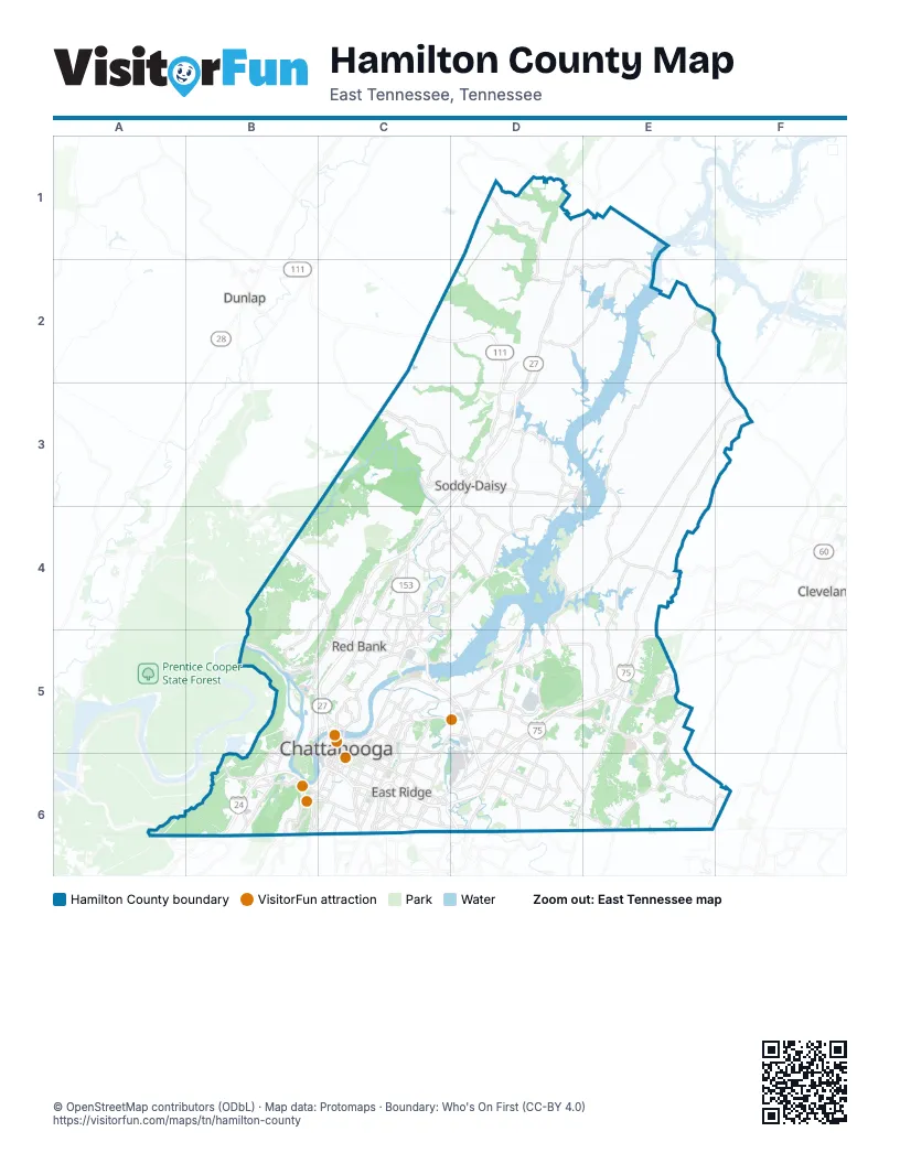
Street index of Hamilton County
Each street on the sheet and the grid squares it crosses.
- Dayton PikeD1, E1, D2, C3, D3, C4
- Old Dayton PikeD2
- Birchwood PikeE2, E3, E4
- Highway 60E2, F2, F3
- Hixson PikeD3, C4, D4, C5
- Tsati TerraceD3
- Highway 58E3, F3, D4, E4, D5
- Georgetown Rd NWF3
- Georgetown Road NorthwestF3
- Taft HighwayB4, C4, B5
- Dayton BoulevardC4, C5
- Harrison PikeE4
- Mahan Gap RoadE4
- Hamm RoadB5, C5
- Moccasin Bend RoadB5
- Mountain Creek RoadB5, C5
- Pineville RoadB5
- Signal Mountain BoulevardB5, C5
- Signal Mountain RoadB5, C5
- Suck Creek RoadB5
- Amnicola HighwayC5
- Ashland TerraceC5
- Barton AvenueC5
- Bonny Oaks DriveC5, D5
- Broad StreetC5, B6, C6
- Campbell StreetC5
- Carter StreetC5, C6
- Cherokee BoulevardC5
- Dodson AvenueC5, C6
- Dupont ParkwayC5
- East 3rd StreetC5, C6
- East 4th StreetC5
- East Martin Luther King BoulevardC5, C6
- Frazier AvenueC5
- Georgia AvenueC5
- Glass StreetC5
- Lake Resort DriveC5
- Mabel StreetC5
- Manufacturers RoadC5
- Market StreetC5, C6
- McCallie AvenueC5, C6
- Morrison SpringsC5
- New York AvenueC5
- North Access RoadC5
- North Holtzclaw AvenueC5, C6
- Riverfront ParkwayC5, C6
- Riverside DriveC5
- Shallowford RoadC5, D5, C6, D6
- Stringers Ridge TunnelC5
- Tunnel BoulevardC5, C6
- Veterans BridgeC5
- West 12th StreetC5, C6
- West 4th StreetC5
- West Martin Luther King BoulevardC5
- Wilcox BoulevardC5, C6
- Wilkes T. Thrasher BridgeC5
- Apison PikeD5, E5, E6, F6
- Hickory Valley RoadD5, D6
- Jenkins RoadD5, D6
- Lee HighwayD5, E5, D6
- Old Lee HighwayD5
- Volkswagen DriveD5
- Main StreetE5
- Ooltewah-Ringold RoadE5, D6, E6
- Pine Hill RoadE5
- South Lee HighwayE5
- Birmingham HighwayB6
- Cummings HighwayB6
- Ochs HighwayB6
- Ochs Highway ExtensionB6
- Old Wauhatchie PikeB6
- Scenic HighwayB6
- South Scenic HighwayB6
- St Elmo AvenueB6
- St. Elmo AvenueB6
- Stonedge PointB6
- Tennessee AvenueB6, C6
- West 40th StreetB6, C6
- 4th AvenueC6
- Alton Park BoulevardC6
- Bachman TunnelC6
- Bailey AvenueC6
- Brainerd RoadC6, D6
- Central AvenueC6
- Dodds AvenueC6
- Dodds Avenue OverpassC6
- Duncan AvenueC6
- East 20th StreetC6
- East 23rd StreetC6
- East 37th StreetC6
- East 38th StreetC6
- East Main StreetC6
- Lindberg AvenueC6
- Mc Brien RoadC6
- Missionary Ridge TunnelC6
- North Germantown RoadC6
- North Moore RoadC6
- North Willow StreetC6
- Page RoadC6
- Probasco PlaceC6
- Ringgold RoadC6, D6
- Rossville BoulevardC6
- S Market StreetC6
- South Germantown RoadC6
- South Holtzclaw AvenueC6
- South Kelley StreetC6
- South Market StreetC6
- South Moore RoadC6
- South Willow StreetC6
- Washington StreetC6
- West 20th StreetC6
- West 38th StreetC6
- West Main StreetC6
- Westside DriveC6
- East Brainerd RoadD6, E6
- Gunbarrel RoadD6
- Weatherly Switch RoadF6
- Wesleyan RoadF6
Things to do on the Hamilton County map
Places on the map
- ADA Loop
- Alco Chemical
- Amberleigh Ridge Apartments
- Apison
- Ardent Mills
- Astec Industries
- Audubon Acres
- Barrington Country Estates
- Bauxite Ridge
- Bay Pointe Drive
- Baylor Lake
- Baylor School
- Bentwood Cove
- Big Soddy Creek Gulf
- Birchwood
- Birchwood Landfill
- Blue Blazes Trail
- Booker T Washington State Park
- Borough 33 Apartments
- Boston Branch Circle
- Bowen Trail
- Boyd-Buchanan School
- Brainerd Golf Course
- Brainerd High School
- Brainerd Park and Rec Center
- Brainerd Village
- Brown Acres Golf Course
- Bunker Hill Loop
- Buzzi Unicem
- Cambridge Apartments
- Camp Jordan Park
- Car Stowage
- Carolana Circle
- Carver Park
- Chattanooga
- Chattanooga Christian School
- Chattanooga Gas Company
- Chattanooga Metropolitan Airport
- Chattanooga National Cemetery
- Chester Frost Park
Next to Hamilton County
- Cleveland
- Dunlap
© OpenStreetMap contributors (ODbL) · Map data: Protomaps · Boundary: Who's On First (CC-BY 4.0)