

Tennessee map
Farragut map
About 25,242 people live here (Census Bureau, 2024 estimate). The sheet's index lists 300 streets; Kingston Pike, North Campbell Station Road and McFee Road cross the most grid squares. Also on it: Ford Farm, Fox Den Country Club and Fox Den Golf and Country Club.
Open the map (PDF, US Letter)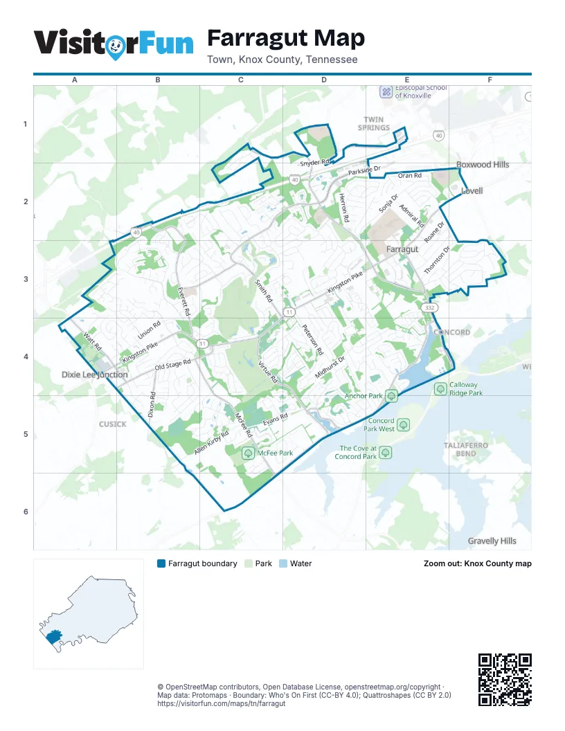
Street index of Farragut
Each street on the sheet and the grid squares it crosses.
- Kingston PikeE2, D3, E3, A4, B4, C4
- North Campbell Station RoadC1, D1, D2, D3, E3
- Concord RoadE3, E4, F4
- South Campbell Station RoadE3
- Watt RoadA4
- Lovell RoadF2
- Turkey Creek RoadE4, D5, E5
- Everett RoadB2, B3, B4
- McFee RoadB4, C4, C5, C6
- Smith RoadB3, C3, C4
- Virtue RoadC4, D4, B5, D5
- Parkside DriveD2
- Grigsby Chapel RoadC2, D2, C3
- Old Stage RoadA4, B4, C4
- Boyd Station RoadD5, C6
- Dixon RoadB4, B5
- Outlet DriveD1, E1
- Snyder RoadD1, D2
- South Watt RoadA4, B4
- Grigsby Chapel GreenwayD2
- Brochardt BoulevardB2, B3, B4
- Farragut Hills BoulevardE3, F3
- Union RoadB3, C3, B4
- Sonja DriveD2, E2
- Midhurst DriveD4, E4
- North Fox Den DriveC3, C4
- Gates Mill DriveD2, E2
- Thornton DriveE2, F2, E3, F3
- Saddle Ridge DriveA3, B3, B4
- Battle Front TrailD4
- Sugarwood DriveC4, D4
- Pryse Farm BoulevardC5
- Glen Abbey BoulevardD3, E3, D4, E4
- East Fox Den DriveC2, C3
- Allen Kirby RoadB5, C5
- Highwick CircleB5, C5
- Barnsley RoadB5, C5
- Gwinhurst RoadC4
- Foxford DriveD4, E4
- Prince George Parish DriveB2, C2
- Evans RoadC5, D5
- Oran RoadE2
- North Monticello DriveC2, D2, C3
- South Fox Den DriveC3, C4
- West Kingsgate RoadD4
- Crown Point DriveF3
- Boring RoadC3, D3
- Ivey Farms RoadB3, B4
- Windham Hill RoadC4
- Butternut CircleC4
- Comblain RoadB3
- Maple Tree DriveA4, B4
- Spinnaker RoadD4, E4, E5
- Belleaire DriveD3, D4
- Pony Express DriveB4
- South Monticello DriveD2, C3, D3
- Peterson RoadD3, D4
- St Andrews DriveC3, B4, C4
- Jamestowne BoulevardD3, E3
- Iron Plow DriveC5, D5
- Fort West DriveB4, B5
- Hickory Woods RoadB2, B3, C3
- Hughlan DriveE2, F2, E3
- Andover BoulevardB3, C3
- Russfield DriveD2, D3
- Herron RoadD1, D2
- Bridgemore BoulevardC5
- Rockwell Farm LaneB4, B5
- Woodland Trace DriveD2, E2
- Broadwood DriveC4, D4
- Banbury RoadD4, D5
- Federal BoulevardD3, D4
- Sweetgum DriveA3, A4
- Long Ridge RoadA3, B3
- South Williamsburg DriveD3
- Augusta National WayC3
- Admiral RoadE2
- Brooklawn StreetE3
- Woodcliff DriveE4
- Farragut Commons DriveD2
- Shirecliffe LaneD4, D5
- Sundown RoadB4, B5
- Split Rail LaneB3
- Saint John CourtC2, C3
- Weatherly Hills BoulevardC2
- Newport RoadE2
- Dundee RoadE2
- Roane DriveE2, E3
- Broken Saddle RoadB5
- Woodsmoke CircleC2
- Red Mill LaneE4
- Georgetowne DriveD3
- Lost Tree LaneC3
- Farr DriveE2, E3
- Triple Crown BoulevardB4, B5
- Way Station TrailB4
- Ridgeland DriveC1, C2
- Briarstone LaneE4
- West End AvenueE2, E3
- Flotilla DriveF3
- West Woodchase RoadC2
- Lakehurst LaneD4, D5
- Campbell Lakes DriveD2
- Chaho RoadD3, D4
- Biddle Farms BoulevardE3
- Brixworth BoulevardD5
- Ivy Lake DriveC5, D5
- South Hobbs RoadB4
- Wells Fargo DriveB4
- Dominion CircleD3
- Wagon Hitch RoadC5, D5
- Long Bow RoadB4, C4
- Lady Slipper LaneA3, A4
- Brookstone DriveD5
- Treyburn DriveA3, B3, B4
- Witherspoon LaneD4, D5
- Butternut LaneC4, D4
- Inglecrest LaneD4, D5
- Burney CircleC3, D3
- Old Colony ParkwayD2
- Providence Glen LaneC5
- Farragut Crossing DriveD3, D4
- Fleenor RoadA4, B4
- North Williamsburg DriveD3
- Heathland DriveB4
- Golden Harvest RoadD4, D5
- Cotton Blossom LaneB2
- Fretz RoadC1, C2, D2
- Boyd Chase BoulevardC4, D4
- Village Commons BoulevardC3, D3
- Old Tavern CircleD2
- Stone Villa LaneC5
- Clover Fork DriveC3, D3
- Somersworth DriveC4
- Hawkstowe LaneE4
- Harrow RoadD4
- Wagon Wheel CircleB4
- Lindsey LaneE4
- Crosswind DriveF3
- Branch Hook RoadC5, D5
- Autumn Leaves LaneD4
- Vista Brook LaneC5, D5
- Pleasant Forest DriveE3
- Lanesborough WayC2
- Scarlet Sage DriveC5, C6
- Southwick CircleB3, C3
- Fordham WayC3
- Weathervane DriveC2, D2, C3
- Lawton BoulevardB4
- Red Canyon RoadB4, B5
- Abners Ridge DriveD5, E5
- Reverence Run RoadD4
- Cool Springs BoulevardA4, B4
- Ivey Farma RoadB4
- Ferret RoadE3, F3
- Oakmont CircleC3, C4
- Dineen DriveE2
- Axton DriveC3, D3
- Bayshore RoadD5, E5
- Park Place BoulevardE3
- Camdenbridge DriveB3
- Nassau DriveD3
- Red Poppy DriveC5, C6
- Turkey Cove LaneE2
- East Kingsgate RoadD4
- Lake Heather RoadE4
- East Heritage DriveD3
- Ackley CircleB3
- Justice Valley StreetD4
- West Point DriveE2, E3
- Windward DriveE3, F3
- Geronimo DriveD3, D4
- Spring Branch LaneE4
- Kendall Hunt StreetD4
- Blackstone DriveC2
- Wyndham Hall WayD2
- Wardley RoadE2
- Fox Dale LaneB3
- Needlegrass LaneC4, D4
- Bob Dagley CircleE2
- Ansley CourtB3, C3
- Lark Meadow DriveD2, E2
- Vista TrailD4
- Anchorage CircleE3, E4
- Briar Gate LaneD2
- Matthews Cove LaneE2
- Baltica LaneB3, B4
- Hatteras DriveE3, E4
- Belle Grove LaneC2
- Buckley RoadA3, B4
- Pecos RoadB3, B4
- West Ashton CourtB3, C3
- Glen Willow DriveD2, E2
- West Heritage DriveD3
- Forest Ridge CircleC1, C2
- Village Green ParkwayD3
- Bigtree DriveD4
- Bellfield RoadD2, D3
- Eisenhower StreetB3
- Sedgefield RoadA4
- Municipal Center DriveD3, E3
- Valley TrailC2, C3
- Oakland Hills PointC3
- Stone Vista LaneC4, D4, D5
- East Ashton CourtB3, C3
- Hampton Roads DriveF3
- Bermuda DriveC3, D3
- Derby Run DriveD3, D4
- Chapel Glen LaneC2
- Lendon Welch WayE2, E3
- Brass Lantern LaneC5
- Champions PointC4
- Brighton CourtB3
- English Station WayD3
- Crystal Brook LaneC2
- Golden Fox LaneB3
- Baltusrol RoadC3, C4
- West Fox Chase CircleC2, C3
- Bancroft LaneD2
- Colonial Ridge LaneE3
- Calloway View DriveF3
- Neptune DriveE3
- North Hobbs RoadB4
- Cross Bridge CircleE4
- Autumn Glade LaneC2
- Mountain View RoadD4
- Sienna LaneB4
- Duzane DriveE2
- Renaissance LaneB4
- Shady Ridge LaneA3, B3
- Chapel Point LaneD2
- Oconnell DriveC2
- Confederacy CircleD3
- Aspenwood DriveC4
- Sailview RoadE4, E5
- Briar Creek DriveD2
- Celebration RoadB4, B5
- Glen Iris LaneD2
- Finch RoadD4, E4
- Lone Willow DriveC5
- Woodchase DriveC2, C3
- Harbor WayE4
- Chowning DriveD3
- Crestview RoadD4
- Moser LaneE3, F3
- Ivey Willow LaneB3
- McGuffeys DriveD5
- Waterslea LaneC5
- Heathermoor DriveC3
- Dixieview RoadD3
- Willow Ridge LaneC4
- Oakley Downs RoadB2
- Dunlin LaneE4
- Altamira DriveC2
- Whispering Hills LaneB3
- Fords Cove LaneE2
- Shadowfax RoadD3
- Fruitwood LaneD4
- Port Charles WayD3, E3
- Cutlass RoadF3
- Blue Heron WayE4
- Green Mountain DriveB2, B3
- Nautical DriveE3, E4
- Bunting DriveD4, E4
- Cottage Creek LaneD2
- Beacontree LaneD2, D3
- Canterbrook RoadC3
- Oxfordshire RoadC3
- Hidden Grove RoadE4
- Lebel RoadB3
- Willingham DriveD5
- Berwick LaneD4
- Butterfield LaneB4
- Chapel Grove LaneD2
- Towne RoadE3
- Olympic DriveC3
- Ivy Chase LaneD2
- Orchard Crossing LaneB4
- Harrison RoadA4
- High Oak RoadA3
- Applegate WayC2
- Stone House LaneB2, B3
- Royal Palm WayA4, B4
- Quail Pointe RoadB4
- Macarthur WayE3, E4
- Sir Goony’sE2
- Cabot DriveD5
- Royal Birkdale RoadC3
- Raeburn LaneD4, D5
- Lake Haven RoadE4
- Meadow Pointe LaneB4
- Saint Charles LaneC2
- Spring Water LaneA4, B4
- Pine Meadows LaneB5
- Lookout PointF3
- Rodeo DriveB4, B5
- Black Powder DriveD4, D5
- Farmgate LaneC5
- Private LaneE3
- Boring LaneD3
Places on the map
- Admiral Dental Care
- Aldi
- Americas Best Value Inn
- Anchor Park
- Brooklawn Center
- Campbell Station Business Park
- Farragut Church of Christ
- Farragut Municipal Center
- Farragut Office Park
- Farragut Primary School
- Farragut School Complex
- Farragut Station
- Farragut Towne Square
- First Baptist Concord
- Ford Farm
- Fox Den Country Club
- Fox Den Golf and Country Club
- Goin' Postal
- Great Lawn
- Knoxville Christian School
- Mayor Bob Leonard Park
- McFee Park
- NHC Commons
- NHC Healthcare - Farragut
- Patriots Corner
- Pleasant Forest Cemetary
- Renaissance Farragut
- Shops at Lovell Place
- Sir Goony's Family Fun Center
- St. John Neumann Catholic Church & School
- Station West
- Sugarwood Recreation Area
- The Lakes at Campbell Station
- Town of Farragut Public Works
- Turkey Creek
- Turkey Creek Medical Center
- Village Green Shopping Center
- West End Center
- Willow Creek Golf Club
Next to Farragut
- Boxwood Hills
- Concord
- Cusick
- Dixie Lee Junction
- Forest Heights
- Gravelly Hills
- Lovell
- Lovell Heights
- Taliaferro Bend
- Twin Springs
© OpenStreetMap contributors, Open Database License, openstreetmap.org/copyright · Map data: Protomaps · Boundary: Who's On First (CC-BY 4.0); Quattroshapes (CC BY 2.0)















