

Tennessee map
Knox County map
About 506,748 people live here (Census Bureau, 2024 estimate). The sheet's index lists 135 streets; Oak Ridge Highway, Kingston Pike and Tazewell Pike cross the most grid squares. Also on it: Adair Park, Adams and Admiral Farragut Park.
Open the map (PDF, US Letter)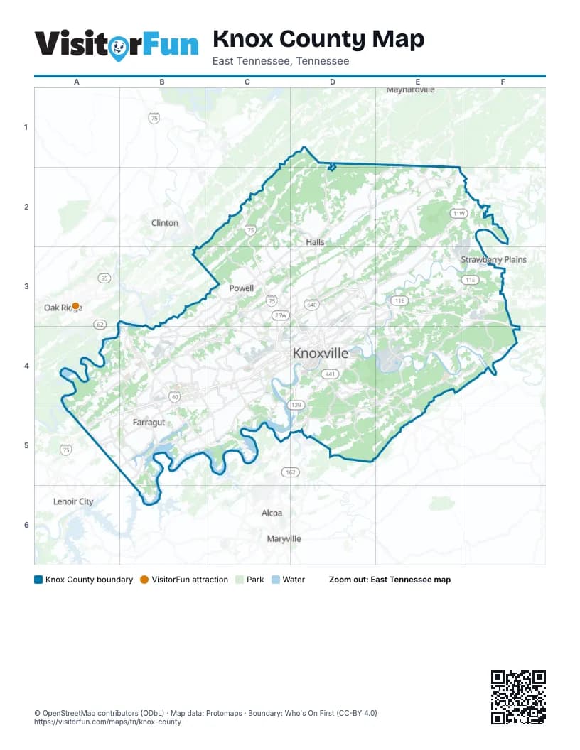
Street index of Knox County
Each street on the sheet and the grid squares it crosses.
- Maynardville PikeD1, D2, D3
- Tazewell PikeE1, D2, E2, D3
- Washington Pike NortheastE1, E2
- East Raccoon Valley DriveC2
- Norris FreewayC2, D2
- Old Raccoon Valley DriveC2
- West Raccoon Valley DriveC2, B3, C3
- East Emory RoadD2, E2, C3, D3
- Mine RoadE2, E3, F3
- New Emory RoadE2
- Rutledge PikeE2, F2, D3, E3
- Washington PikeE2, D3, E3
- Oak Ridge HighwayA3, B3, C3, B4, C4
- Raccoon Valley RoadB3
- West Emory RoadB3, C3, B4
- Callahan DriveC3
- Cedar Lane NortheastC3, D3
- Central Avenue PikeC3, D3
- Clinton HighwayC3, D3
- Gap RoadC3
- Knoxville BypassC3, D3, C4
- Merchant DriveC3
- Pleasant Ridge RoadC3, C4
- Pleasant Ridge Road NorthwestC3
- Powell DriveC3
- Schaad RoadC3, B4, C4
- Tillery RoadC3
- Wilson RoadC3
- Asheville HighwayD3, E3, F3
- Bruhin RoadD3
- Bruhin Road NortheastD3
- Dutch Valley DriveD3
- East Magnolia AvenueD3, D4
- East Woodland AvenueD3, D4
- Mall Road NorthD3
- Mall Road SouthD3
- Martin Luther King Jr AvenueD3, D4
- Millertown PikeD3
- North BroadwayD3, D4
- North Central StreetD3, D4
- North Cherry StreetD3, D4
- Old BroadwayD3
- Prosser RoadD3
- Andrew Johnson HighwayE3, F3
- East Governor John Sevier HighwayE3, E4
- Mascot RoadE3, F3
- McBee Ferry-Mascot BridgeF3
- Hardin Valley RoadA4, B4
- Hickory Creek RoadA4, A5
- Ball Camp Byington RoadB4
- Ball Camp PikeB4
- Beaver Ridge RoadB4
- Byington Beaver Ridge RoadB4
- Byington Solway RoadB4
- Dutchtown RoadB4
- Executive Park DriveB4
- Kingston PikeB4, C4, D4, A5, B5
- Lovell RoadB4, B5
- Middlebrook PikeB4, C4, D4
- Murdock DriveB4
- North Cedar Bluff RoadB4
- Park Village RoadB4
- Parkside DriveB4, B5
- Pellissippi ParkwayB4, B5, C5
- South Peters RoadB4, C4, C5
- Buckingham Drive NorthwestC4
- East Weisgarber RoadC4
- Liberty StreetC4
- Morrell RoadC4, C5
- North Middlebrook PikeC4
- North Northshore DriveC4
- Old Weisgarber RoadC4
- Papermill DriveC4
- South Middlebrook PikeC4
- South Northshore DriveC4, B5, C5
- Vanosdale RoadC4
- West Town WayC4
- Western AvenueC4, D4
- Ailor AvenueD4
- Alcoa HighwayD4, D5
- Alcoa Highway Frontage Road NorthD4, D5
- Alcoa Highway Frontage Road SouthD4, D5
- Anita DriveD4
- Broadway ViaductD4
- Chapman HighwayD4, E4, E5
- Cottrell StreetD4
- Council Place SoutheastD4
- Cumberland AvenueD4
- Dale AvenueD4
- East 5th AvenueD4
- East Blount AvenueD4
- East Hill AvenueD4
- East Moody AvenueD4
- East Summit Hill DriveD4
- Frontage Road NorthD4
- George Dempster DriveD4
- Hall of Fame DriveD4
- Henley StreetD4
- Historic Preservation DriveD4
- James White ParkwayD4
- James White Parkway;Summit Hill DriveD4
- Main StreetD4
- Main Street WestD4
- Maryville PikeD4, D5
- Neyland DriveD4
- North 17th StreetD4
- North 21st StreetD4
- North Gay StreetD4
- Ogle AvenueD4
- Partners PlaceD4
- Sevier Avenue SoutheastD4
- Sevierville PikeD4
- South 17th StreetD4
- South BroadwayD4
- South Gay StreetD4
- Sutherland AvenueD4
- West 5th AvenueD4
- West Hill AvenueD4
- West Martin Mill PikeD4
- West Oldham AvenueD4
- West Summit Hill DriveD4
- West Woodland AvenueD4
- Majestic Grove BoulevardE4
- West Governor John Sevier HighwayE4, D5
- West Norton RoadE4
- Buttermilk RoadA5
- Everett RoadA5
- Watt RoadA5
- Concord RoadB5
- North Campbell Station RoadB5
- South Campbell Station RoadB5
- Westland DriveB5, C5
- Ebenezer RoadC5
- Circle Oak DriveD5
- East Topside Road ConnectorD5
Places on the map
- Adair Park
- Adams
- Admiral Farragut Park
- Admirals Landing
- Alysha's Vineyard
- Amber Glades
- Amber Meadows
- Amberleigh
- Amberleigh Bluff Apartments
- Amherst Ridge
- Anchor Park
- Andes Hill
- Andorian Hills
- Andover Place
- Appaloosa
- Arbor Branch
- Arcadia Peninsula
- Arrowhead
- Ascend at South Knoxville
- Ashby Field
- Ashford
- Ashford Glen
- Ashland Springs
- Ashley Oaks
- Ashridge
- Atlee Fields
- Audubon Hills
- Augusta Hills
- Austin East-Park View
- Austin Homes
- Autumn Ridge
- Autumn Springs
- Autumn View
- Avalon Place
- Averitt Express
- Avian Forest
- Avy Park
- Aylesbury
- Baker Creek Preserve
- Baldwin Park
Next to Knox County
- Alcoa
- Clinton
- Lenoir City
- Maryville
- Maynardville
- Oak Ridge
- Strawberry Plains
© OpenStreetMap contributors (ODbL) · Map data: Protomaps · Boundary: Who's On First (CC-BY 4.0)