

Tennessee map
Kingsport map
About 57,109 people live here (Census Bureau, 2024 estimate). The sheet's index lists 300 streets; James H. Quillen Parkway, East Stone Drive and West Stone Drive cross the most grid squares. Also on it: 2 Ton, Aaron's and Allandale Crossing.
Open the map (PDF, US Letter)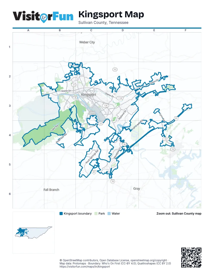
Street index of Kingsport
Each street on the sheet and the grid squares it crosses.
- James H. Quillen ParkwayB2, C2, B3, C3, C4, C5, D5
- North John B Dennis HighwayD2, C3, D3
- East Stone DriveC2, D2, E2, C3, D3
- West Stone DriveB2, C2, A3, B3
- Fort Henry DriveC3, D3, D4, D5
- Airport ParkwayE4, F4
- South John B Dennis HighwayC3, C4
- South Wilcox DriveC3, B4, C4
- Lynn Garden DriveC2, C3
- East Center StreetC3, D3
- Sullivan Gardens ParkwayC4
- West Center StreetC3
- Lee HighwayB3
- Rock Springs RoadC4, D4, C5
- Moreland DriveC4, D4
- Memorial BoulevardD3, E3
- Riverport RoadB3, C3
- Netherland Inn RoadB3, C3
- North Eastman RoadC3, D3
- Lincoln StreetC3
- Ridgefields RoadB3
- Bloomingdale PikeC2, E2
- Clinchfield StreetC2, C3
- West Carters Valley RoadB2, C2
- West Industry DriveC3
- North Wilcox DriveC3
- East Sullivan StreetC3
- East Industry DriveC3
- Old Gibson Mill RoadC2, C3
- East Main StreetC3
- Rock Springs DriveC5
- East Sullivan CourtC3
- Beechwood RoadC3
- Poplar Grove RoadC5
- Jared DriveC3
- East Ravine RoadC3
- Cherokee StreetC3
- Tennessee StreetC3
- East Charlemont AvenueC3
- Boone StreetC3
- West Main StreetC3
- Edgewood StreetC3
- East Ravine Road / Watauga StreetC3
- Cooks Valley RoadD3, D4
- Kendrick Creek RoadD4, C5, D5
- Orebank RoadE2, D3, E3
- East Sevier AvenueC3
- Granby RoadB2, C2
- Fordtown RoadC5, D5
- Shipley Ferry RoadF3, E4, F4
- Watauga StreetC3
- Fairview AvenueC2, C3
- Meadow LaneD4, D5
- Skyland DriveD3, D4
- Fall Creek RoadE3, D4, E4
- Eastern Star RoadD5
- West Ravine RoadC2, C3
- West Sullivan StreetC2, C3
- Virgil AvenueB2, C2
- New Beason Well RoadD2
- Blakely DriveC5
- Lebanon RoadD4, D5
- Fleetwood StreetB3
- Broad StreetC3
- Lynn RoadE3, E4
- Meadowview ParkwayC4
- Island RoadE3
- Fort Robinson DriveB3, C3
- Union StreetB2, B3
- Reservoir RoadB4, C4
- Tranbarger DriveC2
- Thornton DriveD3, D4
- Pendragon RoadB3
- Chippendale RoadB3
- Southgate DriveC4
- Sherwood RoadC3, D3
- Stratford RoadD3
- Warpath DriveD3
- Clouds Ford RoadB2
- Konnarock RoadC3, D3
- Buttermilk RoadE4
- Bell Ridge DriveB2, C2
- Gravely RoadC2
- Hemlock RoadD4
- Harrison AvenueC2
- New Moore RoadC4
- Packing House RoadD2, E2
- Harbor Chapel RoadD3
- May AvenueC2
- Sullivan Gardens DriveB4, C4
- Shadowtown RoadF3
- Bell Ridge RoadB2, C2
- Summerville RoadD4
- Browder RoadE3, E4
- Brickyard Park DriveC3
- Union Hill StreetB2
- Childress Ferry RoadE3, E4
- Eastline DriveD3
- Holston Valley DriveC2
- Bob Jobe RoadD5
- Wampler StreetC2
- Roan StreetC2
- Gravely StreetC2
- East Carters Valley RoadC2
- Peach Orchard DriveC2
- Shipp Springs RoadC2
- Colonial Heights RoadD4
- Fieldcrest RoadE3
- Bays Mountain Park RoadB3, B4
- Lamont StreetC3
- River Mountain RoadB3
- Rocky Branch RoadE3, E4
- Golf Ridge DriveE2, F2, E3
- Mitchell RoadD3, C5, D5
- Brookside DriveD2, D3
- Idlehour RoadC2, D2, C3
- Hidden Acres RoadC5
- Beechwood DriveD4, D5
- Deneen LaneB2, B3
- Ridgecrest AvenueC2
- D AvenueC3
- Edens View RoadE3
- Cox Hollow RoadC5
- Foothills RoadD4, D5
- James C. White DriveC3, C4
- Riverside AvenueC2, C3
- Linville StreetC3
- Hemlock Park DriveD4
- Central AvenueC3
- Lake RoadB4
- University BoulevardA2, A3, B3
- Catawba StreetC3
- Belmeade DriveC3
- Harbor DriveD3
- Wellington BoulevardA2, B2
- Wildwood DriveD3
- Manor DriveB3
- Crescent DriveC3
- A AvenueC3, C4
- Parkway DriveD4
- Hermitage DriveC3, D3
- Ashley StreetD3
- Rivermont CircleB3
- Cleek RoadD2, D3, E3
- Tri-Cities CrossingC5, D5
- Sevier Terrace DriveC2, C3
- Dale StreetC3
- Buckingham CourtD2, D3
- Sumpter RoadC5
- Sussex DriveD2
- Glen Alpine RoadB4
- Stonegate RoadB2, C2
- Mimosa DriveC2
- Mullins StreetC2
- Barnett DriveC4, C5
- Sir Echo DriveD4, D5
- Willowbrook TraceB4, C4
- Buchelew DriveD5
- Stagecoach RoadD3
- Preston Park DriveD3
- Crown CircleE2
- Lewis LaneB2, B3
- Pineola AvenueC3
- Parker LaneB2
- Windridge DriveD2
- Lake StreetB2, C2
- Rotherwood DriveB3
- Westfield DriveC5
- Lakeside DriveD4
- Chickasaw RoadD3
- Highpoint AvenueC2
- Horse Creek LaneC3
- Wandering DriveD2
- Memorial CourtD3
- Fairmont AvenueC2, C3
- Westwind DriveB3
- Midland DriveC3
- Oak StreetC3
- Suffolk StreetD2, D3
- Myrtle StreetC3
- Ridge Line DriveD3
- Garden DriveC3
- East Ridge RoadB4
- Walnut AvenueC2, C3
- Birchwood RoadB3
- Rosetree LaneC2
- Bridwell StreetD3
- F AvenueC3
- Tilthammer DriveB3
- Glory RoadE4
- Bays Cove TrailB3
- Matilda PlaceD3
- Afton StreetB2, B3
- Sheffield StreetD3
- Canongate RoadB3
- Bellingham DriveA3, B3
- Triangle CircleD3
- Arbutus AvenueC2
- Willow StreetC3
- Chestnut Hills DriveE3
- Waverly RoadC3
- Clint StreetC2
- Sam Walton DriveE4
- Wateree StreetC3
- Enterprise PlaceC4
- Brookside LaneD2, D3
- Beechcliff DriveD3
- Hull DriveD4
- Woodridge AvenueD3
- Stonebrook PlaceC2, C3
- Walker StreetC2
- Carolina AvenueC3
- Reedy Creek RoadD3
- Rockford StreetD3, D4
- Church View DriveC5
- Patton StreetB3
- Tiptop AvenueC2
- Sterling LaneD3
- Cliffside RoadD3, D4
- Springfield AvenueC3
- Abilene DriveD3, D4
- Woodmont AvenueC2
- Holyoke StreetC3
- June DriveD3
- Echo AvenueC2
- Countryshire CourtD5
- Jennings DriveB2, B3
- Alderwood DriveD3, D4
- Farragut AvenueD3
- Timberidge TrailB2
- Peppertree DriveC5
- Crest RoadD4
- Brandon LaneD3
- Oakwood DriveC3
- Longreen RoadB3
- East Market StreetC3
- Fiddlers WayC5
- Berkshire LaneD2, D3
- Rock Springs Valley RoadC5
- Rivermont DriveB3
- Hill StreetC3
- Parkcliff DriveD4
- Gustavis AvenueC5
- Mayfield AvenueB2, C2
- Mourning Dove DriveD5
- Starling DriveB2
- Valleydale DriveC5
- Lowell DriveB2, C2
- Dorothy StreetC3
- Truxton DriveC2
- Amersham RoadB3
- Coralwood DriveD5
- Millye StreetD3
- Pinebrook DriveD2, D3
- Louita AvenueB2
- Regional Park DriveC4
- Yadkin StreetC3
- Princeton RoadC4
- River Edge DriveB3
- Bailey Ranch RoadB4
- Sequoyah DriveC2, C3
- Jefferson AvenueD3
- Inglewood DriveD3
- Old Island TrailE2
- White StreetC3
- Fain AvenueC2
- Morison AvenueC2
- Norfolk PlaceD2
- CanterburyB3
- Midfield AvenueB2
- Dale AlleyC3
- Ridgetop TrailE2
- Bruce StreetC3, D3
- Robertson StreetC3
- Oakmont DriveD5
- Warriors Falls DriveE4
- Circle DriveC3
- Essex DriveD3
- High Ridge RoadB3
- De Lee DriveD4
- Pendleton PlaceD3
- Wesley RoadD4
- Clearwater DriveD3, D4
- Rustic WayD3
- Park StreetC3, D3
- Hunters Crossing LaneC4, C5
- Carolina Pottery DriveF3
- Ward PlaceC3
- Pinnacle Ridge CourtD5
- Teasel DriveC2
- South Eastman RoadC3, C4
- Beechnut DriveD3
- Aurawood DriveD2
- Old Castle RoadB3
- Burke DriveB3
- Willowbrook DriveB4, C4
- Ambleside RoadB3
- Bridgewater LaneD3
- Finley Villas CourtB2
- Lovedale DriveC2
Places on the map
- 2 Ton
- Aaron's
- Allandale Crossing
- Allandale Mansion
- Bays Mountain Park & Planetarium
- Bays Mountain Reservoir
- Borden Park
- Brickyard Park
- Cattails at Meadowview
- Cherry Knobs
- Cloud Park
- Colonial Heights
- Crockett Ridge Golf Course
- Dobyns-Bennett High School
- Domtar Park
- Fort Henry Mall
- Highland Park
- Holston Army Ammunition Plant (Area A)
- Holston Valley Medical Center
- Hunter Wright Stadium
- Indian Path Community Hospital
- J Fred Johnson Park
- J. Fred Johnson Stadium
- Jennings Farm
- Kingsport Demolition Landfill
- Kingsport Post Office
- Kingsport Quarry (#525)
- Lighthouse Church
- Long Island
- Lowe's
- Northeast Tennessee Business Park
- Oak Hill Cemetery
- Ridgefields Golf & Athletic Club
- Riverbend Park
- Rocky Hill
- Scott Adams Memorial Skatepark
- Sheridan Square
- Target
- The UPS Store
- Walmart Supercenter
Next to Kingsport
- Fall Branch
- Gray
- Weber City
© OpenStreetMap contributors, Open Database License, openstreetmap.org/copyright · Map data: Protomaps · Boundary: Who's On First (CC-BY 4.0); Quattroshapes (CC BY 2.0)