

Tennessee map
Sullivan County map
About 162,703 people live here (Census Bureau, 2024 estimate). The sheet's index lists 300 streets; Bristol Highway, Tennessee Ernie Ford Parkway and Reservoir Road cross the most grid squares. Things to do inside the boundary: Bristol Motor Speedway.
Open the map (PDF, US Letter)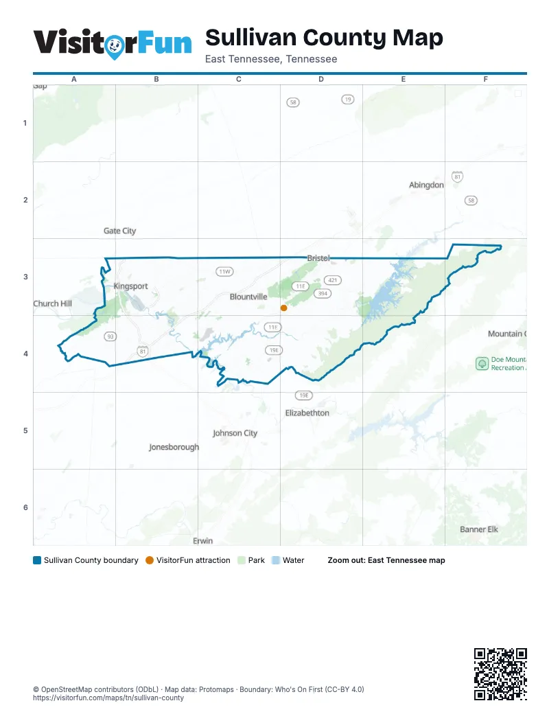
Maps inside Sullivan County
1 map inside, from the street map of Sullivan County down.
Street index of Sullivan County
Each street on the sheet and the grid squares it crosses.
- James H. Quillen ParkwayB3, B4
- North John B Dennis HighwayB3
- Bristol HighwayC3, D3, B4, C4, D4
- Tennessee Ernie Ford ParkwayC3, D3, C4, D4
- East Stone DriveB3, C3
- Volunteer ParkwayD3
- Fort Henry DriveB3, B4
- Hickory Tree RoadD3, E3, D4
- West State StreetD3
- West Stone DriveA3, B3
- Airport ParkwayB3, B4, C4
- Sullivan Gardens DriveA4, B4
- Carl Moore ParkwayD3
- South John B Dennis HighwayB3, B4
- South Wilcox DriveB3, A4, B4
- Blountville HighwayC3, D3
- Lynn Garden DriveB3
- East Center StreetB3
- Anderson StreetC3, D3
- Emmett RoadD3
- Sullivan Gardens ParkwayB4
- Virginia AvenueB3, D3
- Martin Luther King Jr BoulevardD3
- Windsor AvenueD3
- West Center StreetB3
- Rooty Branch RoadD3, E3
- Pennsylvania AvenueB3, D3
- Wadlow Gap HighwayB3
- Sinking Springs RoadD3
- Whitehead RoadC4
- Maple StreetB3, D3, C4
- State StreetD3
- Derby DriveA4
- Emmett WayD3
- Old Stage Coach RoadC3
- Commonwealth AvenueD3
- Indian Creek RoadD4
- Euclid AvenueB3, D3
- Worley DriveD3
- Gate City HighwayD3
- Airport RoadB4
- Memorial BoulevardB3, C3
- Bloomingdale PikeB3, C3
- Weaver PikeD3, D4
- Rock Springs RoadA4, B4
- Moreland DriveB3, B4
- Bluff City HighwayD3, C4, D4
- Lone Star RoadA4
- Bristol Caverns HighwayD3, E3
- Mill Creek RoadA4, B4
- Elizabethton HighwayC4, D4
- Pemberton RoadE3
- Riverport RoadA3, B3
- Edgemont AvenueD3
- Rock Hold RoadD4
- Dry Branch RoadD4
- North Eastman RoadB3
- Lincoln StreetB3
- Netherland Inn RoadA3, B3
- Beechwood RoadB3, D3, B4
- West Carters Valley RoadA3, B3
- Poplar Grove RoadB4
- Rock Springs DriveB4
- Exide DriveC3, D3
- Ridgefields RoadA3
- Clinchfield StreetB3
- Main StreetD3, C4, D4
- West Industry DriveB3
- Jared DriveB3
- North Wilcox DriveB3
- East Sullivan StreetB3
- East Industry DriveB3
- Beech Creek RoadA4
- Old Gibson Mill RoadB3
- East Main StreetB3
- Twin Hill DriveB4
- East Sullivan CourtB3
- Cherokee StreetB3, D4
- East Ravine RoadB3
- Tennessee StreetB3
- East Charlemont AvenueB3
- Boone StreetB3
- West Main StreetB3
- Edgewood StreetB3
- Fleming DriveC4
- East Ravine Road / Watauga StreetB3
- Goodson StreetD3
- Piedmont AvenueD3
- Island RoadB3, C3, D3
- Denton Valley RoadE3, F3
- Muddy Creek RoadC3, C4
- Old Jonesboro RoadD3, C4
- Fordtown RoadB4
- Reservoir RoadB3, A4, B4, D4
- Shipley Ferry RoadC3, B4, C4
- Cooks Valley RoadB3
- Fall Creek RoadB3, B4
- Allison RoadC4
- Pleasant Grove RoadD3, D4
- Orebank RoadB3
- Devault Bridge RoadC4
- Harr Town RoadC3
- Vance Tank RoadD3
- Egypt RoadC4, D4
- Silver Grove RoadD4
- Holston DriveD3, C4, D4
- Broad StreetB3, D3
- Weaver Branch RoadC4
- Lebanon RoadB4
- Summerville RoadB4
- White Top RoadC3, D3
- Vance DriveD3
- Kendrick Creek RoadB4
- Hidden Valley RoadD3, B4
- King College RoadD3
- Piney Flats RoadC4
- Beaver Creek RoadC3, C4
- Shelby StreetB3, D3
- East Sevier AvenueB3
- Knob Park RoadE3
- Gravely RoadB3
- Granby RoadA3, B3
- Hemlock RoadD3, B4
- Childress Ferry RoadB3
- Murrell RoadA4
- Raytheon RoadD3
- Packing House RoadB3
- 6th StreetB3, D3
- 5th StreetB3, D3
- Edgefield RoadD3, C4
- Rangewood RoadC4
- North Austin Springs RoadC4
- New Beason Well RoadB3
- Sweet Knobs TrailD3
- Skyland DriveB3, D3
- Eastern Star RoadB4
- North Pickens Bridge RoadC4
- Pinnacle ParkwayC3, D3
- Meadow LaneB4
- Watauga StreetB3
- Fairview AvenueB3
- Pickens Bridge RoadC4
- Buttermilk RoadB3, B4
- Warren RoadC4
- Fieldcrest RoadB3, C3, D3
- Beidleman Creek RoadD3
- Lynn RoadB3, C3
- Sweet Hollow RoadF3
- Colonial Heights RoadB4
- Bell Ridge RoadA3, B3
- Industrial DriveD3
- Boozy Creek RoadC3
- West Ravine RoadB3
- West Sullivan StreetB3
- Overhill DriveC3
- Virgil AvenueB3
- East State StreetD3
- Blountville BoulevardC3
- Shadowtown RoadC3
- Blakely DriveB4
- East Cedar StreetD3
- New Bethel RoadC4
- Feathers Chapel RoadC3
- Fleetwood StreetA3
- Meadowview ParkwayB3
- Cedar Valley RoadD3
- Union StreetB3, D4
- Old Weaver PikeD4
- Harrison AvenueB3
- Merman RoadB4
- Fort Robinson DriveA3, B3
- Southside AvenueD3
- Tranbarger DriveB3
- Thornton DriveB3
- Hill RoadC3
- Pendragon RoadA3
- Chippendale RoadA3
- Bell Ridge DriveB3
- Broyles LaneD3
- Shipp Springs RoadB3
- Southgate DriveB3
- Sherwood RoadB3
- Old Thomas Bridge RoadC3, D3
- Airport CircleC4
- Old Mill RoadB3
- Stratford RoadB3
- Ash StreetB3, D3
- Austin Springs RoadC4
- Oakdale RoadB3, C4
- Warpath DriveB3
- Earhart RoadC3
- Old Fordtown RoadB4
- East Carters Valley RoadB3
- Lakeview DriveC4
- Clouds Ford RoadA3, B3
- Konnarock RoadB3
- New Moore RoadB3, B4
- Franklin DriveC3
- Lavinder LaneD3
- Steele Creek DriveD3
- 24th StreetD3
- College AvenueD3
- Harbor Chapel RoadB3
- Blackley RoadD3
- May AvenueB3
- Summer Hills DriveC3
- Hickory Hill RoadB3, D4
- Baileyton RoadA4
- Fernwoods Private DriveD3
- Hazelwood StreetD3
- Browder RoadB3
- 8th StreetD3
- Brickyard Park DriveB3
- Union Hill StreetB3
- 17th StreetD3
- Peach Orchard DriveB3
- Eastline DriveB3
- Holston Valley DriveB3
- Bob Jobe RoadB4
- Wampler StreetB3
- Peters StreetD3
- Craig DriveD3
- Roan StreetB3
- Gravely StreetB3
- Willmary RoadC4
- Top TreeC3
- King StreetB3, D3
- Horton HighwayA4
- Ford Creek RoadB4
- Big Creek RoadE3, D4, E4
- Bullock Hollow RoadD3, D4
- Ryder Church RoadD4
- Riverside RoadD4
- Massengill RoadC3
- Chinquapin Grove RoadD4
- South Holston Dam RoadD3, E3
- Hamilton RoadC4
- Reedy Creek RoadB3, C3
- Enterprise RoadC4
- Mitchell RoadB3, B4
- Centenary RoadB4, C4
- Old Blairs Gap RoadA4
- Flatwoods RoadD4
- Walnut Grove RoadD4
- Hunting Hill RoadC4
- Old Elizabethton HighwayD4
- Carolina AvenueB3, D3
- Dunlap RoadB4, C4
- Flat Woods RoadD4, E4
- Big Hollow RoadC3, C4
- Bays Mountain Park RoadA3, B3, A4
- Big Springs RoadD4
- Mount Holston RoadD4
- Timber Ridge RoadD4
- Bethel DriveC3, D3
- V I Ranch RoadD3, E3
- Hawley RoadC3, C4
- Troublesome Hollow RoadD3, D4
- Mountain View DriveD3, C4
- Brookside DriveB3, D3
- Shady View DriveB4
- Fairview School RoadC4
- Rocky Branch RoadB3, B4
- Wahoo Valley RoadB4
- Lakeview Dock RoadE3
- Meadow View RoadD3, E3
- Bancroft Chapel RoadB3
- Big Ridge RoadA4
- Sky-Wa-Mo RoadD4
- Haw Ridge RoadC4
- Cross Community RoadC3
- Paperville RoadD3
- Cox Hollow RoadB4
- Carden Hollow RoadC3
- Government RoadF3
- Paddle Creek RoadD3, D4
- Beechwood DriveD3, B4
- Church RoadA4
- Lamont StreetB3
- Summer Sound RoadC4
- Cedar Branch RoadB3
- Panhandle RoadD4, E4
- River Mountain RoadA3, B3
- Gottland Shoals RoadB4
- Buffalo RoadC4
- Rock City RoadB3, C3
- Sugar Hollow RoadC4
- Huffman RoadC4
- Glen Alpine RoadA4, B4
- Lakeridge StreetB4
- Princeton RoadA4, B4
- Camp Tom Howard RoadE3
- Sharps Creek RoadE3
- Morrell Creek LaneD4
- Goverment RoadF3
- Morelock StreetB3
- Painter Creek RoadE3
- Bunker Hill RoadC4, D4
- Beulah Church RoadB4
- Chestnut Ridge RoadB3
Things to do on the Sullivan County map
Places on the map
- Bays Mountain Park & Planetarium
- Bays Mountain Reservoir
- Bloomingdale
- Blountville
- Bluff City
- Boone Lake
- Brickyard Park
- Bristol
- Bristol Business Park
- Cattails at Meadowview
- Colonial Heights
- Crockett Ridge Golf Course
- Dam Builders Trail Loop
- Dobyns-Bennett High School
- Fall Creek Loop
- Five Fillies Farm
- Fort Henry Mall
- Fort Patrick Henry Lake
- Glenwood Cemetery
- Holston Army Ammunition Plant (Area A)
- Holston Valley Medical Center
- Indian Path Community Hospital
- Kingsport
- Kingsport Demolition Landfill
- Kingsport Quarry (#525)
- Long Island
- Osceola Island
- Slagle Hollow
- South Fork Holston River
- South Holston Lake
- Spurgeon
- Steele Creek Lake
- Steele Creek Park
- The Golf Club of Bristol
- Tri Cities Golf Club
- Trinkle Hollow
- Walnut Hill
- Warriors Path State Park
- Warriors' Path State Park
Next to Sullivan County
- Abingdon
- Banner Elk
- Church Hill
- Elizabethton
- Erwin
- Gate City
- Johnson City map
- Jonesborough
- Mountain City
© OpenStreetMap contributors, Open Database License, openstreetmap.org/copyright · Map data: Protomaps · Boundary: Who's On First (CC-BY 4.0); Quattroshapes (CC BY 2.0)