

Tennessee map
Sevier County map
About 100,184 people live here (Census Bureau, 2024 estimate). The sheet's index lists 300 streets; Parkway, Ridge Road and River Road cross the most grid squares. Things to do inside the boundary: Anakeesta, Apple Barn Cider Mill & General Store and Dolly Parton's Stampede.
Open the map (PDF, US Letter)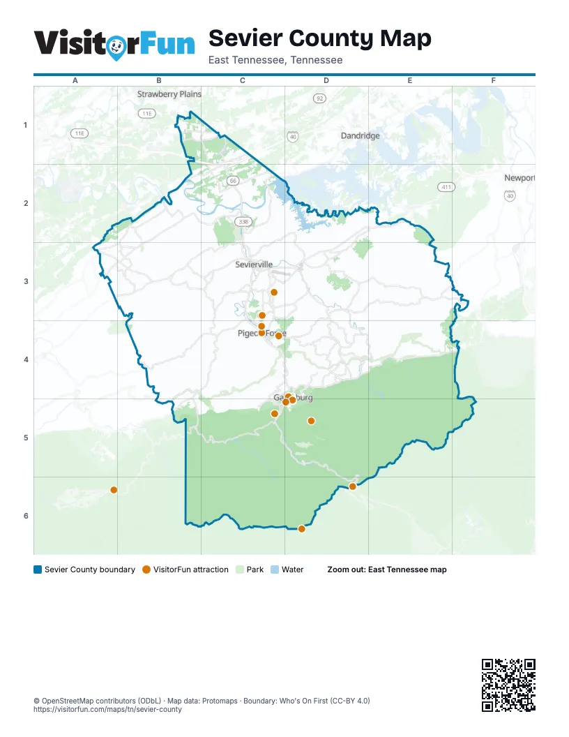
Street index of Sevier County
Each street on the sheet and the grid squares it crosses.
- Winfield Dunn ParkwayC1, C2, C3
- ParkwayC3, C4, D4, C5, D5
- East ParkwayD4, E4, F4
- Newfound Gap Road NorthC5, D5, D6
- Chapman HighwayA3, B3, C3
- Wears Valley RoadC3, B4, C4, B5
- Veterans BoulevardC3, C4
- Newport HighwayD2, D3
- Gatlinburg Spur RoadC4, D4
- Gatlinburg Bypass RoadC4, D4, C5
- US 411D2, E2
- Asheville HighwayB1, C1
- Dolly Parton ParkwayC3, D3
- Gatlinburg Spur Road (north)C4, D4
- West Main StreetC3
- Snyder RoadC1
- Maryville HighwayA3, B3
- Dollywood LaneC4
- North ParkwayC3
- Forks of the River ParkwayC3
- East Main StreetC3
- Gatlinburg Spur Road (south)D4
- Gatlinburg Spur CutoverC4
- Newfound Gap Road SouthD6
- Douglas Dam RoadB1, C1, C2
- Pittman Center RoadD3, D4, E4
- Jones Cove RoadD3, E3, F3
- Boyds Creek HighwayB2, C2, B3
- Old Newport HighwayD2, E2, C3, D3
- Little River Gorge RoadB5, C5
- Fighting Creek Gap RoadC5
- Birds Creek RoadD3, D4
- Jake Thomas RoadC3, C4
- Teaster LaneC3, C4
- Middle Creek RoadC3
- Glades RoadD4
- Foothills ParkwayB4, B5
- Park RoadC3
- Buckhorn RoadD4
- Collier DriveC3
- Old State Hwy 66C2
- Eastgate RoadC3
- Long Springs RoadD3
- Foothills Parkway West Access RoadB4
- East Wears Valley RoadC3
- Waldens Creek RoadB4, C4
- Ridge RoadB1, B2, C3, C4, D4
- Upper Middle Creek RoadD3, C4, D4
- Old Knoxville HighwayC2, C3
- Goose Gap RoadC3, C4
- Allensville RoadC2, D2, C3
- Gists Creek RoadB3, C3
- Pearl Valley RoadE3
- Boogertown RoadD4
- Sugar Loaf RoadB3, C3
- Wiley Oakley DriveC4, D4, C5
- Richardson Cove RoadD3, E3
- Wye DriveA3, B3
- Jayell RoadC3, D3
- South Old Sevierville PikeA3, B3
- North Knob Creek RoadA3, B3
- Ski Mountain RoadC5
- Thorngrove PikeB1, C1
- Bryan RoadC1, C2, C4
- East Union Valley RoadB2
- Grassy Branch RoadD4
- New Era RoadC3
- McCarter Hollow RoadC3, D3
- Old Mountain RoadD4
- Lane Hollow RoadD2, D3
- Porterfield Gap RoadB2, B3
- King Hollow RoadD4
- Tittsworth Springs RoadA3, B3
- McCleary RoadB2
- Dixon Branch RoadD3
- Kodak RoadB2, C2
- Ogle RoadA3, D4
- Ernest McMahan RoadC3, D3
- South New Era RoadC3
- East Dumplin Valley RoadC1
- Walnut Grove RoadD3
- Lower Powdermill RoadD4
- Campbell Lead RoadC4, D4, C5
- Oldham Creek RoadD4
- West Union Valley RoadB2, B3
- Old Birds Creek RoadD4
- Cartertown RoadD4
- Rays Gap RoadB2
- Cate RoadC1, C3
- Gateway BoulevardC1, C2
- Powdermill RoadD4
- Bogard RoadE3, F3
- Line Springs RoadB4, B5
- Greystone Heights RoadD4, D5
- Zion Hill RoadB3
- Shady Grove RoadD4
- North Rogers RoadB3
- Proffitt RoadD4
- Wear Cove Gap RoadB5
- West Dumplin Valley RoadC2
- White School RoadC3
- Chilhowee School RoadB3
- Dudley Creek RoadD4
- New Center RoadD3
- North Bryan WayC1
- Hodges Bend RoadB2
- Cross Over RoadD3
- Center View RoadC3
- Bruce StreetC3
- Whites School RoadC3
- Mills Park RoadD4
- Old US 411D2, E2
- Prince StreetC3
- Henderson AvenueC3
- Catons Chapel RoadD4
- Railroad StreetC3
- Blanton DriveC3
- Old Mill AvenueC4
- Gary R Wade BoulevardC3
- High StreetC3
- Lewelling RoadC3
- Christmas Tree LaneC3
- East Millers Cove RoadB4
- Jeffries Hollow RoadA3
- Old Sevierville PikeA3
- West Bruce StreetC3
- Henry Town RoadD3, E3
- Alpine DriveE2, E3
- Wilhite RoadE3
- Rocky Flats RoadE3, E4
- Happy Hollow RoadD2, D3, B4, B5
- Roaring Fork Motor Nature TrailD4, D5
- Bent RoadB2, C2
- Maples Branch RoadD3
- Mill Creek RoadC4
- Happy Creek RoadB2, B3
- Cherokee Orchard RoadD5
- Bluff Mountain RoadB3, B4, C4
- Little Cove RoadC4
- Sims RoadC2, D2
- Locust Ridge RoadD3, E3, D4, E4
- Kyker Ferry RoadC2
- Greenbrier CoveD4, E4, E5
- Sharp RoadD3
- Flat Creek RoadD2
- Thomas Cross RoadE2, E3
- River Divide RoadC3
- Black Oak Ridge RoadD2, A3
- Caney Creek RoadC4
- River RoadB2, C2, C3, C5, D5
- Goose Creek RoadB3
- Mountain Preserve DriveB4
- Red Bud LaneD2, D3, D4
- King Branch RoadC4, D4
- Robert Henderson RoadC3, D3
- Fish House WayC4, C5
- Summit Trails DriveB4
- Loop RoadB2, D4, D5
- Hardin LaneC3
- Shiloh Church RoadB3
- Providence RoadC2, D2
- Dupont RoadB3
- Cummings Chapel RoadD3
- Indian Gap RoadB2, C2, C3
- South Rogers RoadB3
- Long Branch RoadB3, D4
- Blowing Cave RoadE2
- Estates DriveA2, A3
- Laurel Creek RoadE4
- Kerr RoadD2
- Mountain Ashe WayE3
- Millican Grove RoadC2, D2
- Pinnacle Vista RoadE4
- Alder Branch RoadC2
- Pine Mountain RoadC4
- North Panther Creek RoadB2, B3
- Indian Warpath RoadB2
- Hatcher Mountain RoadB4, C4
- Cove Mountain RoadC4, C5
- Johnson RoadB2, C2, B3
- Red Bank RoadD3
- Seaton Springs RoadD3
- Grassy Branch LoopD4
- Gnatty Branch RoadC4, D4
- Deer Path LaneE4
- Pullen RoadC3, D3
- Crescent WayD4
- Byrds Cross RoadE2
- Little Valley RoadB4, C4
- North Clear Fork RoadB4
- Sharp Hollow RoadC3
- Fox Hunters LaneD4
- Pine Ridge RoadB2
- Katy Holler RoadB5, C5
- North Shiloh RoadB3
- Nuns Cove RoadD3, E3
- McCleary Bend RoadB2
- Arch Rock DriveD3
- Shell Mountain RoadE3
- Bluff Ridge RoadB3, C3
- Norton Creek RoadC4
- Silver Poplar LaneD4
- Bear Mountain WayD3, D5
- Cedar Springs Valley RoadB2
- Kellum Creek RoadC2, C3
- Allen RoadC2, D3
- Hickman RoadB1, B2
- Sugar Maple LoopB4
- McMahan Sawmill RoadB4
- Ski View LaneD4
- John Sevier DriveE3
- Smoky Crossing WayB3
- Hardin RoadC1, C3
- South Delozier RoadB3
- Mitchell Farm RoadD3
- Lost Branch RoadC4
- Valley View RoadC4
- Hodges Ferry RoadC2
- Dripping Springs RoadB3, B4
- Huskey Grove RoadD4
- Lin Creek RoadE3
- Wesley WayE3
- Matthews Hollow RoadC3
- Enclave Park WayC4
- Branam Hollow RoadE4
- Powder Springs RoadC2, D2
- Mathis Branch RoadE4
- Thomas Loop RoadE2, E3
- Snapp RoadD3
- Panther Creek RoadB3, C3
- Mountain DriveD3, D4
- Sunrise BoulevardC2, C3
- Covemont RoadC4
- Butler Branch RoadE4
- Settlers View LaneB4
- Overholt TrailB4
- Mutton Hollow RoadC1, C2
- Roberts RoadC2, C3
- Old Happy Hollow RoadD2, D4, E4
- Emerald Springs LoopB4
- Shady RoadB1
- South Shiloh RoadB3
- Reed Schoolhouse RoadC2, C3
- Ski View DriveC5
- Fox Cemetery RoadE2
- Bear Mountain LaneD3, E3
- Obes Branch RoadE3
- Reagan Springs RoadB3
- South Clear Fork RoadB4
- County Line RoadE2, A3
- Sugar Hollow RoadC3
- Magaret Hollow WayB4
- Headrick LeadB4
- Rainbow RoadC3
- Graves Delozier RoadB3
- Stepping Stone DriveB4
- Easy StreetC4
- Creswell RoadB2
- Bruce RoadD4
- Ridgecrest DriveB2, B3, C3, C4
- Yellow Breeches RoadE3
- Riversong WayD4, E4
- Fain RoadE2
- Topside DriveC2, C3, D3, D5
- Apple Valley RoadC3
- Robinson Gap RoadC2
- Elkmont RoadC5
- Eagle View DriveC2
- East Walnut Grove RoadD2, D3
- Denton RoadC3
- Windfall Estates DriveD2
- Legacy Vista DriveD3
- Ramsey Prong RoadE5
- Illinois AvenueB2
- Young Blood WayE3, F3, F4
- West Flat Creek WayD2
- Stanton RoadB3
- Forest Trail DriveE3, E4
- Cove Mountain WayC4
- Allenridge DriveD3
- Crown Point LaneB4
- Dollys DriveD4
- Cypress Cove RoadD3
- Little Cove Church RoadC4
- Buena Vista DriveC4
- White Oak DriveB3, D3
- Sugarloaf Mountain RoadB3
- Mountain BoulevardD3, D4
- Silverbell DriveE3
- Village Loop RoadC4, D4
- Caton Branch RoadD4
- Spence Mountain LoopD3
- Ravens Den WayC4
- Timber Ridge WayD4
- Laurel Luck RoadC4
- Loposser Hollow RoadB3
- Blue Springs WayB4
- Azalea TrailE3
- Kings Hills BoulevardC4
- Roundtop DriveB5
Things to do on the Sevier County map
- Anakeesta
- Dolly Parton's Stampede
- Dollywood
- Gatlinburg SkyBridge & SkyLift Park
- Great Smoky Mountains National Park
- Newfound Gap
- Ober Mountain
- Ripley's Aquarium of the Smokies
- Ripley's Believe It or Not! Odditorium
- Roaring Fork Motor Nature Trail
- Tanger Outlets Sevierville
- The Island in Pigeon Forge
- The Old Mill
- The Parkway
- Titanic Museum Attraction
Places on the map
- 411 Motor Speedway and Dragway
- Alpine Hideaway Campground
- Anakeesta
- Bears
- Bent Creek Golf Course
- Boyds Creek
- Buc-ee's
- Camp Riverslanding
- Clabough's Campground
- Club Wyndham Smoky Mountains
- Creekside Golf Course
- Dollywood
- Dollywood Theme Park
- Dollywood's DreamMore Resort
- Dollywood's Splash Country
- Douglas Headwater Campground
- Douglas Tailwater Campground
- Elk Springs Resort
- Elkmont Campground
- Fox Meadows Business Park
- Gatlinburg
- Gatlinburg Golf Course
- Gatlinburg Skypark
- Governor's Crossing
- Great Smokies Flea Market
- Great Smoky Mountains National Park
- Greenbrier Campground
- Island Pointe Golf Club
- Jayell Ranch Adventure Park
- Kodak Quarry (#545)
- Mount Le Conte
- Ober Mountain
- Pigeon Forge
- Pittman Center
- Sevierville
- Sevierville Golf Club
- Sevierville Quarry
- Seymour
- Stadium Acres
- Two Rivers Landing
Next to Sevier County
- Dandridge
- Newport
- Strawberry Plains
© OpenStreetMap contributors, Open Database License, openstreetmap.org/copyright · Map data: Protomaps · Boundary: Who's On First (CC-BY 4.0); Quattroshapes (CC BY 2.0)