

Tennessee map
Sevierville map
About 18,231 people live here (Census Bureau, 2024 estimate). The sheet's index lists 300 streets; Winfield Dunn Parkway, Old Knoxville Highway and Burridge Drive cross the most grid squares. Things to do inside the boundary: Apple Barn Cider Mill & General Store and Tanger Outlets Sevierville.
Open the map (PDF, US Letter)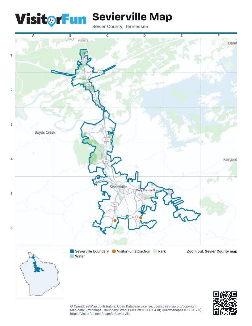
Street index of Sevierville
Each street on the sheet and the grid squares it crosses.
- Winfield Dunn ParkwayB1, B2, C2, C3, C4, C5
- Veterans BoulevardD5, D6
- ParkwayC5, C6
- Dolly Parton ParkwayD5, E5
- West Main StreetC5
- Snyder RoadB1
- North ParkwayC5
- Forks of the River ParkwayC5
- East Main StreetC5, D5
- Middle Creek RoadD5, D6
- Old Newport HighwayD5, E5
- Boyds Creek HighwayB3, C3
- Park RoadC5
- Pittman Center RoadE5, E6
- Collier DriveC6, D6
- Douglas Dam RoadB2, C2, C4
- Eastgate RoadC5, D5
- Old Knoxville HighwayB3, C3, C4, C5
- Ridge RoadC5, D5, D6
- Gists Creek RoadC4
- Gateway BoulevardB2, C2
- Ernest McMahan RoadD5, E5
- West Dumplin Valley RoadB2
- Cate RoadC5, C6
- New Era RoadC6
- Bryan RoadC1, C2
- East Dumplin Valley RoadB1, C1
- Allensville RoadC4, C5
- Bruce StreetC5
- Prince StreetC5
- Henderson AvenueD5
- Railroad StreetC5, D5
- Blanton DriveD5
- Gary R Wade BoulevardC5
- High StreetC5
- West Bruce StreetC5
- Jayell RoadE6
- Lewelling RoadC6
- North Bryan WayC1
- Maggie Mack LaneC5
- Hardin LaneC5
- Apple Valley RoadC6
- Tramel RoadC5
- Robert Henderson RoadD5
- Old Douglas Dam RoadC4, C5
- Big River Overlook DriveB3, C3
- Burridge DriveC4, D4, C5, D5
- Oak Haven WayB3, C3
- Murphy's Chapel DriveE5
- Shaconage TrailE5
- Snapp RoadE5
- Millwood DriveD5
- Kyker Ferry RoadC2, C3
- Denton RoadD6
- Jasmine TrailE5
- Red Bank RoadE6
- Valley RoadC6
- Red Cedar Ridge RoadB3, C3, C4
- Howard DriveD4, D5
- Country Meadows DriveE5
- Smithwood RoadC5, C6
- Burden Hill RoadD5
- Bass Pro DriveB1
- Smoky Mountain CircleC5
- McCroskey Island RoadC3
- Parker BoulevardB2
- Reed Schoolhouse RoadB4, C4
- Stadium DriveB1
- Mayors RoadC5
- Catlett RoadD5
- Badger RoadC3
- Lena LaneC1
- Buc-ee's BoulevardB2, C2
- Alder Branch RoadC3
- Cedar Hills RoadC5
- Kingfisher AvenueC5
- East Hardin LaneC5
- Turtle Dove TrailE5
- Longview DriveC3, C4
- Foxwood DriveD5
- Shannon CircleD5
- Robert Ridge RoadD6
- Court AvenueC5
- Beverly Hills DriveC5
- Jersey DriveC4, C5
- Lonesome Valley RoadC6
- Riverview CircleC6
- South Fork DriveD6
- Fine Glen DriveD5, D6
- Sugarland LaneD6
- Business Center CircleC3
- Jim Hickman DriveE5
- Cherokee CircleD5
- Ella DriveD6
- Rivergate DriveE5
- Candy Tuft DriveC5, D5
- River RoadD5
- River Valley CircleD5
- Murphy CircleC5
- Hurley DriveC6
- Counselor DriveC5
- Hideaway RidgeC5
- Hicks DriveC5
- Bluegrass RoadD5
- Birchwood LaneD5
- Edgewater DriveD5
- East Ridge RoadD5, D6
- Blake LeaD5
- Huskey DriveD5
- Saint Ives DriveD5, D6
- Rainbow RoadC6
- New Riverside DriveE5
- Summerfield LaneE5, E6
- Hardin Hills RoadC4
- McMahan AvenueD5
- Cedar StreetC5
- Village DriveD5
- Love RoadC5
- North Smoky Mountain WayC4
- Topside RoadC4, C5
- Mountain Valley LaneD6
- Pheasant Ridge RoadC4
- Broadview DriveC5
- Walnut WayC6
- South BoulevardC5
- Teague RoadC6
- West Mount RoadB2, C2
- Industrial Park DriveD5
- Lynn DriveC6
- Island BoulevardB3
- Outdoor Sportsmans PlaceB1, B2
- Evergreen DriveC5
- Emily DriveC4
- King RoadA1, B1, B2
- Maples Branch RoadE5
- Columbine LeaD5
- Cherokee Path WayC4
- Ralph Conner WayC5, C6
- Snyder Road SouthB2, C2
- Two Rivers BoulevardC3
- Avery LaneC5, C6
- Air Museum WayD5
- Overlook DriveC4
- Cedar LaneC5
- Catlettsburg RoadC4
- Paine Lake DriveC5
- Vista CircleC5, D5
- Ogle LaneC6
- Sunrise CircleD5
- Bear Run WayC6
- Thurman CircleE5
- Country Colonial StreetC5, D5
- Chelsea Jo LaneE5, E6
- Blue Bonnet DriveC5
- Alderman RoadC5
- Ownby CircleD5, D6
- North Circle DriveC5
- Meadow Ridge CircleE5
- Lenz DriveB1
- London LaneD5
- South Smoky Mountain WayC4
- Buena DriveC5
- Caton RoadC6
- Beechview DriveD5
- Belle Meadows BoulevardD5
- River Garden CourtC5
- Kildee LaneE5
- Davis LaneC3
- Riverdale DriveD5
- Lexington PlaceC5
- Center StreetC5
- Hollywood CircleC5
- Lee Greenwood WayC3
- Briar LeaD5
- Riverpark WayC4
- Murphy RoadC5
- Longspur TrailC4
- Panorama DriveC5
- Ownby DriveC5
- Hopson StreetC3, C4
- Swaggerty RoadC2
- Middle Ridge RoadD6
- Knife Works LaneC3
- Marshell Springs WayC6
- Victorias LodgeD5
- Woodland DriveD5
- Tanager StreetC5
- Kilby StreetC5
- Happy Trails WayC5
- Silver WayC6
- Dickey DriveE5
- Leo Sharp RoadD5
- Fox Meadows BoulevardD5
- Smokey Mountain WayC4
- Smokyview DriveD6
- Beal Woods DriveD5
- Grandview DriveC2, C3
- Oak DriveC5
- Airport RoadD5
- Grace AvenueC5
- Scenic DriveC5
- Spencer Clack LaneC5
- Berry Trail DriveD5
- Cate Byrd RoadC1
- Hawk Hollow DriveD4, D5
- Mark Ann DriveC5
- Markhill DriveC5
- Cherokee Circle DriveD6
- Reese RoadC5
- Broad AvenueC5
- Royal Heights DriveC4
- Swans Ferry RoadC4
- Ambrose Paine LaneC5
- Temple DriveC5
- Rivers Edge LaneD5
- South Circle DriveC5, C6
- Spicer LaneD5
- Whispering Pines WayB3, C3
- East Casey DriveD4, D5
- Byrd DriveB1
- Paine StreetC5
- Mark Ann LaneC5
- Vista DriveC5
- Jaguar DriveC3
- French Broad CircleC3
- Club DriveC5
- Riceland DriveD6
- Mountain View DriveC5
- Oak Haven CourtC3
- George E Davis DriveD5
- John L Marshall DriveC5
- Cherokee DriveC6
- Hazel DriveC5
- Monarch CircleE5
- Nichols StreetC5
- Crescent DriveC4, C5
- Ellendale CoveD6
- Issac Thomas LaneC5
- Riversbottom DriveD5
- Styles RoadB1
- Wilderness Path WayC6
- Norton StreetC6
- Pullen RoadD5, D6
- Hickman RoadB1, B2
- Tsali WayC4
- Sunrise LaneC5
- Cherry StreetC5
- Huffaker RoadC3
- Hummingbird LaneC5
- Wagner DriveD5
- Hickory Ridge WayC6
- Warbler PointC4
- Connie Huston DriveC5
- Walter Webb DriveD5
- Echota WayC4
- Industry DriveD5
- Meadow LaneC5
- Riverbrook DriveD5
- River North BoulevardC5
- North Riverview CircleC5
- Wilson RoadD6
- Delta WayD5
- Wall StreetD5
- Blalock DriveC6
- Kathern StreetC5
- Chilhowee DriveC5
- Laurel Falls LaneD6
- East Mount RoadC2
- Bogart DriveC5
- Cedar TerraceD5
- Cabin Creek WayC5
- Creek AvenueC5
- Y RoadC5
- Fowler RoadD5
- Cody DriveC4
- East View StreetC4, C5
- Franklin DriveC4
- Mary Kay DriveD6
- Heatley LaneD5
- Hickory RidgeC5
- Allensville Square RoadC4
- Mize LaneC5
- C P Wilson DriveD5
- Bobwhite TrailC4
- Hemlock CourtD5
- Project StreetD5
- Pigeon River RoadD5
- Poplar StreetD5
- McCarn CircleC5
- Apple Ridge WayC5, D5
- Wisteria LaneC6
- Spring StreetC4
- Little Pigeon RoadC6
- Scarlett Meadows DriveE5, E6
- Estate DriveC6
- Beech RoadC5
- United BoulevardC4
- North Henderson AvenueD5
- Amy LeaD5
- Walnut RoadC5
Things to do on the Sevierville map
Places on the map
- 7 Brew
- A&L RV Sales
- Advance Auto Parts
- Aldi
- Apple Barn Winery
- Buc-ee's
- City of Sevierville Public Works
- Clayton Homes
- Club Wyndham Smoky Mountains
- Creekside Medical Park
- Fox Meadows Business Park
- Governor's Crossing
- Governor's Crossing Mall
- Great Smokies Flea Market
- LeConte Medical Center
- Northview Optmist Park
- Oak Cluster Park
- Oak Haven Park
- Ripplin Waters RV Park & Cabin Rentals
- River Plantation RV Resort
- Riverside RV Park & Resort
- Rocky Top Chrysler Jeep Dodge
- Scenic Helicopter Tours
- Sevier County Utility District
- Sevierville City Park
- Sevierville Convention Center
- Sevierville Golf Club
- Sevierville Quarry
- Sixty Six Heliport
- Smokies Business Center
- Smoky Mountain Circle
- Soaky Mountain Water Park
- Sportsman Acres
- Stadium Acres
- Tanger Outlets Sevierville
- The Ridge Outdoor Resort
- Two Rivers Landing
- Two Rivers Landing RV Resort
- Veterans Business Park
- Walmart Supercenter
Next to Sevierville
- Boyds Creek
- Fairgarden
- Four Points
© OpenStreetMap contributors, Open Database License, openstreetmap.org/copyright · Map data: Protomaps · Boundary: Who's On First (CC-BY 4.0); Quattroshapes (CC BY 2.0)















