

Texas map
Burleson map
About 56,253 people live here (Census Bureau, 2024 estimate). The sheet's index lists 300 streets; South Burleson Boulevard, Southwest Wilshire Boulevard and East Renfro Street cross the most grid squares. Things to do inside the boundary: Burleson Museum and Visitors Center.
Open the map (PDF, US Letter)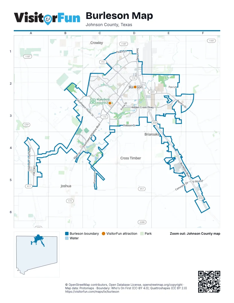
Street index of Burleson
Each street on the sheet and the grid squares it crosses.
- Chisholm Trail ParkwayA4, A5
- South FreewayD1
- Southwest Wilshire BoulevardD2, C3, D3, B4, C4
- Northeast Wilshire BoulevardD2
- North Broadway StreetB4
- South Burleson BoulevardD2, D3, E3, E4, E5, F5, F6
- Northwest John Jones DriveC2, C3
- East Hidden Creek ParkwayE2, D3, E3
- East Renfro StreetD2, E2, E3, F3
- Southwest Alsbury BoulevardB2, C2, D2, B3
- Northwest Renfro StreetC1, C2, D2
- North Burleson BoulevardD1, D2
- South Hurst RoadE2, E3
- West Hidden Creek ParkwayC3, D3
- Northeast Alsbury BoulevardD1, D2
- Southeast John Jones DriveC3, C4
- East FM 917F5
- Conveyor DriveC5, E5, F5
- West Renfro StreetD2
- Hidden Creek ParkwayE2, D3, E3
- Alsbury BoulevardD1
- Crowley RoadC2
- East Alsbury BoulevardD1
- Southeast Hidden Creek ParkwayC3
- FM 1902A4, A5
- Southwest Hulen StreetB2, B3, C3
- Northwest Summercrest BoulevardC2, D2
- South Dobson StreetD2, D3
- Greenridge DriveC3, B4
- Lakewood DriveB4, C4
- Candler DriveC2, C3
- Northeast McAllister RoadC1, D1, C2
- Clubhouse DriveC4
- Village Creek ParkwayD2
- Dobson StreetD3
- Southeast Gardens BoulevardD2, D3
- Hidden Vistas BoulevardD3
- Hemphill StreetD1, D2
- Caddo School RoadA4, B4
- County Road 913A4, B4
- Forrest LaneC5
- Southwest Thomas StreetC2, D2
- West Bend BoulevardC2
- Southwest Hillside DriveC2, C3
- Southwest Johnson AvenueD2
- West Bethesda RoadE4
- Edgehill RoadC2
- County Road 802C4, C5
- County Road 602E3, E4
- Elk DriveC3
- County Road 531E2, F2
- North Main StreetD2, B4
- West County Road 714C3, D3
- Tarver RoadD3
- South West Forrest LaneC5
- County Road 920B2, C3
- Houston RoadE2
- Commons DriveC3
- County Road 715D3
- Centre DriveD2
- McCall StreetD2
- County Road 805D3
- East Bethesda RoadE4
- RanchwayC4
- Northwest SummercrestC2
- Tantarra DriveC3
- County Road 1021B3, C3, B4
- Cardinal Ridge RoadE2, E3
- Irene StreetD2, D3
- Ranchway DriveB4, C4
- Fox LaneE2
- Greenway DriveC4
- Northwest Lorna StreetD2
- Prairie Timber RoadB3
- Vantage DriveE5, F5
- Wilshire Boulevard NED2
- Northwest Jayellen AvenueC2, C3
- Northwest Hillery StreetD2
- Southwest Rand DriveC2, D2
- Northwest Newton DriveC2, D2
- Peach LaneC1, D1
- Northwest Tarrant AvenueC2, D2
- Northwest Park Meadow LaneD1
- Wicker Hill RoadC3, C4
- Patterson CircleC3
- Mockingbird LaneB4
- Highpoint ParkwayE5
- Cedar Ridge LaneC2
- South Briaroaks RoadE4, E5
- North Commerce StreetD2
- McNairn RoadC2, C3
- Monticello DriveE3
- Northwest Charlyne DriveC2, D2
- Southwest Murphy RoadC2, D2
- Parkview DriveC2, D2
- Morgan DriveC2
- South Fox LaneE2, E3
- Mockingbird Hill RoadE4
- Northwest Douglas StreetD2
- Windy Meadows DriveC1
- Buffalo RunB4, C4
- Country Vista CircleB4
- County Road 810 NorthF5
- Streamside DriveC4
- Lynnewood AvenueD3
- Northwest Wintercrest RoadC2
- Foxglove LaneC1, D1
- Northeast Murphy RoadD2
- Chisenhall Park LaneD3
- Vaughn DriveC2
- Thistle Meade CircleC3
- Shoreline DriveC4, C5
- Linda DriveC2, C3
- Northwest King StreetD2
- County Road 1016B2
- Flagstone DriveC2
- County Road 910A5
- Lakeside DriveB4, C4
- Valley Ridge RoadE3
- Queen Annes DriveC1
- Potomac DriveC3
- Parkridge BoulevardE2, E3
- Arnold AvenueC3, D3
- SunnybrookC2, D2, C3
- Tinker TrailD2, D3
- County Road 1020B3
- Downwood DriveC1
- Fairfield PkwyC3
- Plum DriveD1
- Big Horn DriveD3
- Barkridge TrailC2, D2
- Glade Meadows DriveA5
- Evandale RoadE3
- Northwest Suzanne TerraceC2, C3
- Richard StreetB4
- Northwest Jill Ann DriveC2, C3
- Reverie RoadC3
- Oak StreetD3
- Jeffdale DriveC2, C3
- Mary Ann LaneE3, F3
- Hollow Creek RoadE2
- Brown Crest RoadC2
- Southwest Gregory StreetD2
- Pinnacle DriveC4
- Hidden Lake DriveD3
- Judith StreetD3
- Bowden CircleE2
- Northwest Barbara LaneC2, D2
- East Ellison StreetD2
- Northeast Michael DriveD2
- Marcia LaneC2
- Owl ParkwayA5
- Royal Oak LaneE3
- Broad Valley CourtD3
- Broad Valley DriveD3
- South Warren StreetD2
- Northeast Brushy Mound RoadC1, D1, C2
- Litchfield LaneE3
- Northeast Cindy LaneD2
- Northwest Ann Lois LaneC2, D2
- St AndrewsC4
- Hearthstone DriveC2
- Remington CircleC3
- Miles AvenueC3
- Tara DriveE3
- Pleasant Manor AvenueD3
- Vaden AvenueC3, D3
- Valley Terrace RoadE3
- Heberle DriveD1
- Coral Vine LaneC1, D1
- Lariat LaneE2, F2, E3, F3
- Litchfield CircleE3
- Bretts WayC2, C3
- Meador LaneD3
- Willie WayD3
- Northwest Sandra LaneC2, D2
- Shady Oaks DriveC1, D1, C2
- James CircleD1, D2
- Castle Pines DriveC4
- Bur Oak DriveD1
- Pin Cushion TrailC1
- Lisa StreetD3
- Bonnards Peak RoadB3
- Coleman RoadE2, F2
- Flamingo CircleE2
- Memorial PlazaD2
- Southeast Newton DriveD2
- Grassy Meadows DriveA5
- Marybeth DriveC2
- Valley Crest DriveD3
- Hawks Ridge TrailB4, C4
- Nathan StreetD2
- Southwest Brushy Mound RoadC2
- Merced StreetC3
- Linden DriveD1
- Destrehan DriveE3
- Sue Ann LaneD3
- Jessica DriveD1
- Lovie Thomas LaneF3
- Southeast Gregory StreetD2
- Hillside DriveC3
- Krista DriveC2, C3
- County Road 530BE3
- Cozby LaneD3
- Reagan LaneC2, C3
- Beverly DriveF3
- Lauren DriveC2
- Northeast Timber Ridge DriveC2, D2
- Northwest Chisholm StreetD2
- Aurora Hills TrailC3, C4
- Highcrest DriveC1
- Nutmeg AvenueC3
- Stillwater DriveC3
- Steven StreetD3
- Vinewood DriveC3
- Ridgehill DriveC2
- Sierra Vista DriveC2
- Yukon DriveC3
- Springhill DriveE2
- Wysteria LaneC1
- Glenn RanchC4
- Northeast Taylor StreetD2
- East Miller StreetD2
- Jennifer DriveC2, C3
- Teton DriveD3
- North Hurst RoadD2
- Chimney Rock RoadB4, C4
- Southeast Robert StreetD2
- Windridge LaneD1
- Cumberland DriveC2
- Meadow Ridge DriveC1
- Silverthorne DriveC2
- Southwest Taylor StreetD2
- Winepress RoadC3
- Southwest Cindy LaneD2
- Market StreetD2
- Allegheny DriveD3
- Meandering LaneC2
- South Scott StreetD2
- Colorado DriveC3
- West Eldred StreetD2
- McKavett DriveC2
- Southwest Anderson StreetD2
- Southwest Moody StreetD2
- Falls Creek CourtB3
- Arbor LaneD1
- Southeast Tarrant AvenueD2
- Oak Valley RoadE2
- Cirrus DriveE5
- Tioga StreetC3
- Laramie LaneC3
- Landview DriveD3
- North Rudd StreetD2
- WilliamsE4
- Vicksburg LaneD1
- Misty Oak TrailC2
- Sandy Hill RoadE3
- Darren DriveC3, D3
- Pleasant Valley DriveD1
- Lakeview CircleC4
- Joshua DriveC2
- White Marlin DriveC2
- Clarimont LaneC2
- Sweetwater DriveC2
- Carol LaneF3
- HuebnerE2, E3
- Spring Meadows DriveD1
- Barberry DriveE3
- Cindy CourtE3, F3
- Heritage TrailD2, D3
- South Wilson StreetD2
- Benjamin DriveC2
- Evergreen LaneD1
- Grant StreetC2
- West Bufford StreetD2
- Bluebird Meadows DriveA5
- Blueridge DriveC2
- Ben Thomas StreetB4
- Northeast Moody StreetD2
- Delaware StreetC3
- Barbara Jean LaneC2
- Glen Oak DriveE2, E3
- Crestview DriveC2
- Fraser DriveC3
- Rushmore DriveD3
- East Tabb StreetD2
- Oakdale DriveC4
- Creekview DriveC2
- Jacobs Crossing CourtC2
- Pebble Creek DriveC2
- Riverbank DriveC4
- Lena LaneD2
- Hudson LaneC3
- Southwest Dian StreetD2
- Aaron DriveC2
- Southwest Southridge DriveC2, D2
- Oakbrook DriveC4
- Boone RoadD1
- Mesquite StreetD1
- North Dobson StreetD2
Things to do on the Burleson map
Places on the map
- Academy at Nola Dunn
- Academy of Arts at Bransom
- Advantage Storage
- Alley Cats
- Bailey Lake
- Bailey Lake Park
- Bailey Park - Little Free Library
- Bartlett Park
- Brushy Mound
- Burleson Fire Station Number 1
- Burleson High School
- Burleson Plaza
- Burleson Town Center
- Caddo Grove Elementary School
- Centennial High School
- Centennial Park
- Chisenhall Fields
- Chisenhall Park
- Clinkscale Elementary
- Coyote Loop
- Eagle Postal Center
- Elk Plaza
- Frazier Elementary School
- Hajek Elementary School
- Heritage Lake
- Hidden Creek Golf Course
- Hidden Creek Sports Complex
- Hughes Middle School
- Kerr Middle School
- McNairn Plaza
- Meadowcrest Park
- Mountain Valley Lake Number 1
- Mountain Valley Lake Number 2
- North Joshua Elementary School
- North Texas Yogi Bear's Jellystone Park
- Norwood Elementary School
- Oak Valley Park North
- Prairie Timber Park
- Wakefield Heights Park
- Wilshire Senior Living
Next to Burleson
- Briaroaks
- Cross Timber
- Crowley map
- Joshua
© OpenStreetMap contributors, Open Database License, openstreetmap.org/copyright · Map data: Protomaps · Boundary: Who's On First (CC-BY 4.0); Quattroshapes (CC BY 2.0)















