

Texas map
College Station map
About 128,023 people live here (Census Bureau, 2024 estimate). The sheet's index lists 300 streets; William D Fitch Parkway, Harvey Mitchell Parkway South and South Highway 6 cross the most grid squares. Things to do inside the boundary: George Bush Presidential Library and Museum, Museum of the American GI and Post Oak Mall.
Open the map (PDF, US Letter)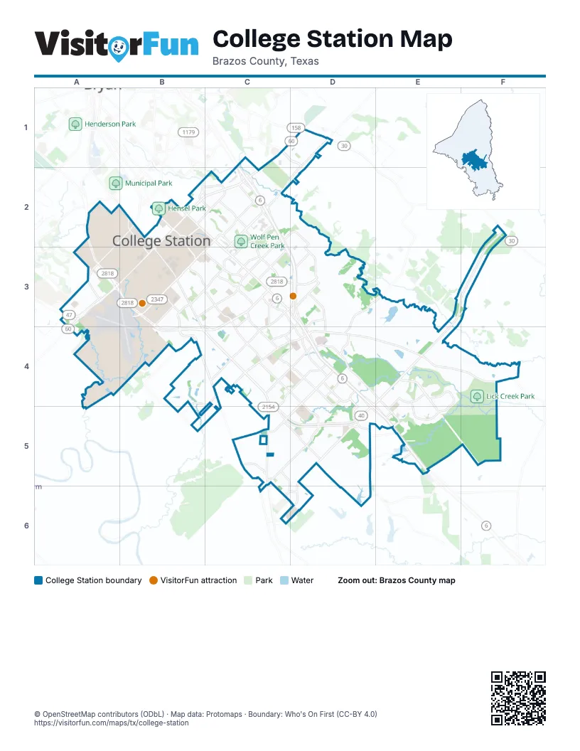
Street index of College Station
Each street on the sheet and the grid squares it crosses.
- South Earl Rudder FreewayC1, C2, C3, D3
- North Earl Rudder FreewayC1
- William D Fitch ParkwayF2, E3, F3, C4, D4, E4, C5, D5
- Harvey Mitchell Parkway SouthA2, A3, B3, C3, D3, B4, C4
- South Highway 6C3, D3, D4, D5, E5
- Wellborn RoadB2, B3, B4, C4, C5
- South Earl Rudder Freeway Frontage RoadC1, C2, C3, D3
- Texas Avenue SouthB2, C2, C3
- University Drive EastC1, D1, B2, C2
- Raymond Stotzer ParkwayB2, A3, B3
- University DriveB2
- John Sharp ParkwayA3
- North Harvey Mitchell ParkwayA2
- Rock Prairie RoadC4, D4, E4, F4
- Harvey RoadD1, C2, D2, C3
- Barron RoadD4, C5, D5
- Southwest ParkwayC2, B3, C3
- Welsh AvenueB3, C3, C4
- George Bush Drive WestB3
- George Bush DriveC2, B3, C3
- Bizzell StreetB2, B3
- George Bush Drive EastC2, C3
- South College AvenueB2
- Tarrow StreetB2, C2
- North Earl Rudder Freeway Frontage RoadC1
- Tarrow Street EastB2, C2
- East Tarrow DriveC2
- East 29th StreetB2
- Holleman Drive SouthB4, C4, C5
- Victoria AvenueC4, D4, C5, D5
- Greens Prairie Road WestD5
- Lakeway DriveD4, E4, E5
- Longmire DriveC3, D3, D4
- Pebble Creek ParkwayE4, E5
- Dartmouth StreetC2, C3
- Royal Adelade LoopE4, E5
- Deacon DriveC3, C4
- F & B RoadB2, A3
- Arrington RoadD4, D5
- Appomattox DriveC2, D2, D3
- Holleman DriveB3, C3
- Eagle AvenueC4, D4, C5
- Emerald ParkwayD3
- Graham RoadC4, D4
- Rock Prairie Road WestB4, C4
- Alexandria AvenueD4
- Greens Prairie TrailD5, C6, D6
- Anderson StreetB3, C3
- Creek Meadow Boulevard NorthC5, D5, C6, D6
- Saint Andrew's DriveE4, E5
- Dominik DriveC2
- Deacon Drive WestB4, C4
- W.S. Phillips ParkwayC5, D5
- Bird Pond RoadD3, E3, D4
- Brothers BoulevardC3, C4
- Holleman Drive EastC2, C3
- Royder RoadC5, C6, D6
- Copperfield ParkwayC1, D1
- Rio Grande BoulevardC3, C4
- Decatur DriveD4
- Lincoln AvenueB2, C2
- Penberthy BoulevardB3
- Glade StreetB3, C3
- Town Lake DriveD4
- Krenek Tap RoadC3
- Luther Street WestB3, B4
- Munson AvenueC2
- Turkey Creek RoadA3
- Southern Plantation DriveD4, D5
- Raintree DriveC2, D2, D3
- North Graham RoadC4, B5, C5
- Southwood DriveC3
- Holleman Drive WestB3, B4
- Foxfire DriveD3
- Spearman DriveE4
- Woodcreek DriveD3, D4
- Finfeather RoadA2, B2
- Sebesta RoadD3
- Normand DriveC3, C4, D4
- Dexter Drive SouthB3, C3
- New Main DriveB2
- Health Science Center ParkwayA3
- Stonebrook DriveD3, D4
- Agronomy RoadB2, B3
- Jones-Butler RoadB3, B4
- South Dowling RoadC5
- Balcones DriveC3, C4
- North Dowling RoadB4, B5
- North Forest ParkwayD3
- Ponderosa DriveD3, C4, D4
- Spring LoopB2, C2
- Sandstone DriveD3
- Glenhaven DriveC2
- Brentwood Drive EastC3
- Arnold RoadC4, D4
- North Traditions DriveA2, A3
- Parkview DriveE4, E5
- Schaffer DriveC4, D4
- Nantucket DriveE5
- Dexter DriveB3
- Gateway BoulevardE5
- Capstone DriveC5
- Brentwood DriveC3
- Ponderosa RoadC4
- Arrington DriveD4
- Venture DriveE5
- Backwater LaneC6
- South Oaks DriveE5
- Copperfield DriveC1
- I&GN RoadC5
- Olsen BoulevardB3
- Research ParkwayB3
- Nuclear Science RoadB3, B4
- Park PlaceB3, C3
- John Kimbrough BoulevardB3
- Francis DriveC2
- Williams Creek DriveE4, F4
- Toledo Bend DriveD4
- University Oaks BoulevardC2
- Old Main DriveB3
- Windham Ranch RoadD5
- Frost DriveD3
- Langford StreetC3
- Walton DriveB2, C2
- Navarro DriveC3, C4
- McKenzie Terminal BoulevardA3
- Castlegate DriveD5
- Edelweiss AvenueC4
- Olden LaneE3, E4
- Johnson Creek LoopE4, F4
- Ashburn AvenueC2
- Barron Cut Off RoadC5, D5
- Old Wellborn RoadC4
- Papa Bear DriveC4
- Barbara Bush DriveB3
- Augusta CircleE4
- Houston StreetB2, B3
- Veterans ParkwayC1, C2
- Todd TrailC3
- Ravenstone LoopD5
- Etonbury AvenueD5
- Central Park LaneC2, C3, D3
- Momentum BoulevardC1, D1
- Crescent Pointe ParkwayC1, D1
- Feather Run StreetB4, C4
- Gilchrist AvenueC2
- Austin AvenueC3
- Great Oaks DriveB4
- Bradley RoadE3, E4
- Treehouse TrailC3, D3, C4
- Carter Lake DriveE3
- Observatory RoadA4, B4
- Quality CircleE5
- Newport LaneD4
- Old Ti RoadC1, C2, D2
- Coral River RoadD5
- Rockingham LoopD5
- Marion Pugh DriveB3, B4
- Brookwater CircleD3
- Rockcliffe LoopD5
- Newark CircleD5
- Fairview AvenueB3
- Kendall Green CircleD5
- Puryear DriveC2
- Windmeadows DriveD4
- Diamondback DriveD5
- Nueces DriveC3
- Capps DriveC4
- Double Mountain RoadD4
- Birmingham RoadD4
- Congressional DriveE4, E5
- Baker Meadow LoopC5, D5, D6
- Foster AvenueB2, C2
- Technology LoopB3
- Church AvenueB2
- Lewis StreetB3
- West Campus BoulevardB3
- Manuel DriveC2, C3
- Towers ParkwayC4
- Stonebriar CircleE4
- Discovery DriveB3
- Mission Hills DriveE4
- Castle Rock ParkwayD5
- Live Oak StreetB2, C5
- Cain RoadC4
- Brewster DriveC5, D5
- Westchester AvenueC4
- Faulkner DriveD3
- Slocum Hill DriveB4, C4
- Rock Bend DriveD5
- Airline DriveC3
- Hawk Tree DriveC3
- Post Oak BendC5, D5
- Holden CircleF4
- Merry Oaks DriveC2
- General ParkwayB4, C4
- Winding RoadB3, C3
- Dairy Center RoadA2, B2
- Joe Routt BoulevardB3
- Woodlake DriveC5, D5
- Coke StreetB3
- Laura LaneC3
- Oldenburg LaneC4
- Pershing AvenueB3, C3
- Portland AvenueC5, D5
- Richards StreetC2, C3
- Spence StreetB2, B3
- Still Creek LoopC5
- Pebble Bend DriveE4
- Spring CreekD3
- Crested Point DriveD4
- Milner DriveB2, C2
- Valley View DriveC3
- Calaveras CourtD4
- Plum Hollow DriveE5
- Quarry Oaks DriveE4, E5
- Nagle StreetB2, B3
- Redmond DriveC3
- Stone Castle CircleD5
- Montclair AvenueB3
- Haines DriveC3
- Pearl River CourtD5
- Forest DriveC2
- Buena Vista DriveD1
- Harris DriveE3, D4
- Sterling StreetC2, C3
- Norwich DriveD5
- Haverford RoadB4
- Throckmorton StreetB3
- James ParkwayC2
- Hartford DriveC4
- Holik DriveC3
- Chestnut Oak CircleD3
- Hunter Creek DriveD4
- Mortier DriveC4
- Ross StreetB2
- McCullough RoadC5
- Autumn CircleB2, C2
- Odell LaneD5
- Village DriveC3
- Lamar StreetB2, B3
- Amistad LoopD4
- Nimitz StreetB2
- Waxwing LaneC4
- Keefer LoopC4
- Switch Station RoadC2
- Eisenhower StreetB2
- Luther StreetB3
- Colgate DriveC2, C3
- Spanish Moss DriveF4
- Timber Creek LaneD6
- Creagor LaneD4
- Hensel DriveB2
- Brandenburg LaneC4
- Legendary DriveD5
- Angelina CircleC3
- Pierre PlaceC3, C4
- Adrienne DriveC3, C4
- Regal Oaks DriveD5
- Cross StreetB2
- Trumpeter Swan DriveD3
- San Saba DriveC3, C4
- Timber StreetB3, C3
- West Ridge DriveC4
- Jennifer DriveC3, C4
- Junction Boys RoadB4
- Sawgrass DriveE4
- San Benito DriveC3, C4
- Lee AvenueB3, C3
- Stoney Creek LaneD4
- Long Creek LaneD5, D6
- Cloisters DriveE3
- Bayou Woods DriveC2
- Boyett StreetB2
- Polo RoadB2
- Emerald Dove AvenueD4
- Lady Bird LaneD4
- Medina DriveC3
- Rose CircleC2
- Berkeley StreetC2
- Dove Chase LaneD4
- Momma Bear DriveC4
- Fontaine DriveD3
- Hereford StreetB3, C3
- Northrup-Grumman RoadD2, D3
- Hayes LaneC4
- Nottingham DriveC4
- Pronghorn LoopC4
- Coronado DriveC4
- Caudill StreetC3
- Cullen TrailC4
- Silver Oak DriveD5
- Vienna DriveC4
- Horse Haven LaneC2
- Old Arrington RoadD5
- Dove Run TrailD4
- Dover Landing AvenueD4
- Kernstown LaneD4
- Neal Pickett DriveC2
- Abbate RoadB4, C4
Things to do on the College Station map
Places on the map
- A&M Bus Depot
- A&M Consolidated High School
- Aggie Field of Honor
- Aggie Park
- Aggie RV
- Anderson Athletic Park
- Bachmann Park
- Barracks Airborn Park
- Bee Creek Park
- Brayton Fire Training Field
- Bridgewood Park
- Brison Park
- Brothers Pond Park
- Caprock Crossing
- Carter Lake
- Central Station
- Century Square
- College Station High School
- Dale Watts 71' Cross Country Course
- Fan Field
- Gateway Shopping Center
- Hensel Park
- Lick Creek Park
- Park Place Plaza
- Parkway Square
- Pebble Creek Golf Course
- Post Oak Mall
- Post Oak Shopping Center
- Research Park
- Southwood Park
- Spearman Lake
- Stephen C. Beachy Central Park
- Texas A&M University
- The Golf Club at Texas A&M
- Thomas Park
- Tower Point
- Veteran's Park & Athletic Complex
- W.A. Tarrow Park
- Wildwood Park
- Wolf Pen Creek Park
© OpenStreetMap contributors, Open Database License, openstreetmap.org/copyright · Map data: Protomaps · Boundary: Who's On First (CC-BY 4.0); Quattroshapes (CC BY 2.0)















