

Texas map
Corsicana map
About 25,591 people live here (Census Bureau, 2024 estimate). The sheet's index lists 300 streets; West Park Row Boulevard, East State Highway 31 and South US Highway 287 cross the most grid squares. Things to do inside the boundary: Corsicana Visitors Center.
Open the map (PDF, US Letter)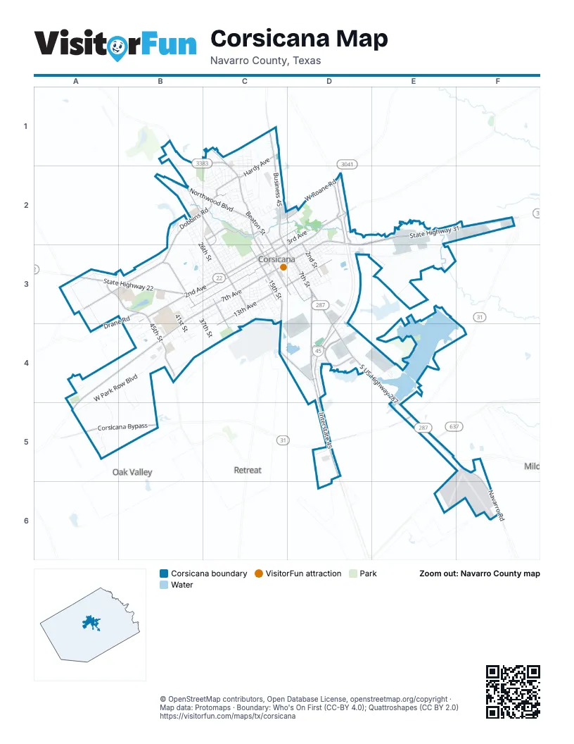
Street index of Corsicana
Each street on the sheet and the grid squares it crosses.
- East State Highway 31D2, E2, F2, D3
- South US Highway 287D3, D4, E4, E5
- West 2nd AvenueB3, C3
- West 7th AvenueB3, C3, B4
- South 15th StreetC3, C4, D4
- West State Highway 31A4, B4, A5
- North Business 45C1, C2
- Corsicana BypassA5, B5, D5, E5
- South Business 45D3, D4
- West State Highway 22A3, B3
- Martin Luther King Jr BoulevardD2, D3
- South 7th StreetD3
- North 15th StreetC3
- North 7th StreetC2, D3
- East State Highway 22B3
- East 7th AvenueC3, D3
- T A Carroll AvenueD3
- South Interstate 45D3, D4, D5
- North Interstate 45D2
- North Beaton StreetC1, C2, C3
- West 3rd AvenueB3, C3
- West Roane RoadC2, D2
- Emhouse RoadB1, C1
- FM 744A3, B3
- East 3rd AvenueD2, C3
- South Beaton StreetC3, D3
- FM 637E5
- Dobbins RoadB2, C2, B3
- West 5th AvenueB3, C3
- Corsicana Crossing BoulevardD4
- Northwood BoulevardB2, C2
- North 45th StreetA3, B3, B4
- West 13th AvenueC3, D3, C4
- Bowie DriveB2, C2, C3
- Oaklawn DriveC2
- G W Jackson AvenueD2, D3
- North 24th StreetC2, C3
- North 37th StreetB3
- North 13th StreetC2, C3
- Navarro RoadF5, F6
- East 13th AvenueD3
- Hardy AvenueC1, C2
- South 45th StreetB4
- South 12th StreetC3, D3
- South 2nd StreetD3
- Forrest LaneC2
- South 31st StreetC3, C4
- East 1st AvenueC2, D2
- South 24th StreetC3
- Drane RoadB3
- South 16th StreetC3
- North 12th StreetC2, C3
- East 5th AvenueD2, C3, D3
- North 2nd StreetD2, D3
- Lakeview DriveD4
- Northeast County Road 0070D2
- West Park Row BoulevardB3, C3, A4, B4, A5
- West 4th AvenueB3, C3
- West Collin StreetB3, C3
- Liberty DriveA4, A5
- West 6th AvenueC3
- Navarro DriveC1, C2
- West 11th AvenueC3, D3
- West 1st AvenueC2, B3, C3
- Southeast County Road 0010D3, E3
- North 26th StreetB2, B3, C3
- West 10th AvenueC3
- West Park AvenueB3, C3
- Corsicana State HomeB3, B4
- West 12th AvenueC3, D3
- Oak Valley RoadB4, C4
- East 10th AvenueC3, D3
- Southeast County Road 0060E4, E5
- East 6th AvenueD2, C3, D3
- East Collin StreetD2, C3, D3
- West 9th AvenueC3
- East 9th AvenueD2, D3
- West 8th AvenueB3, C3, B4
- South 18th StreetC3
- Country Club RoadB1, B2
- Southeast County Road 0020D3
- South 9th StreetC3, D3
- North 29th StreetB3, C3
- North Commerce StreetC2, C3
- East 11th AvenueD3
- Elmwood AvenueB3, C3
- North Main StreetC2, C3
- Hidden Hills DriveB4, B5
- South 3rd StreetD3
- East 12th AvenueD3
- South 4th StreetD3
- South 5th StreetD3
- Fish Tank RoadB2, C2
- North 22nd StreetC2, C3
- Sycamore AvenueC3
- Lake Halbert RoadE4
- South 37th StreetB3, C4
- South Main StreetC3, D3
- North 19th StreetC3
- South 1st StreetD2, D3
- East 8th AvenueD2, D3
- South Benton StreetD2, D3
- South 14th StreetC3
- Shady Creek LaneF6
- South 30th StreetC3, C4
- Northwest County Road 2010A3
- North Bunert StreetD2
- North 23rd StreetC3
- North 23 1/2 StreetC3
- Skyline AvenueB4
- North 28th StreetC3
- McKinney AvenueB2, C2
- North 25th StreetB2, C2, C3
- Oakridge DriveC1, C2
- North 5th StreetC2, D2, D3
- West 15th AvenueC3, C4
- Black Hills RoadB2
- South 8th StreetD3
- North 3rd StreetD2, D3
- South 20th StreetC3
- South 29th StreetC3, C4
- East 4th AvenueD2, C3, D3
- South 19th StreetC3
- West 14th AvenueC3, C4
- Bowie CircleB2
- Interurban BoulevardC1, C2
- Madison DriveC2
- Wesley DriveC2
- South 17th StreetC3
- Payne StreetA5
- South 18th 1/2 StreetC3
- East 16th AvenueD3
- North 38th StreetB3
- South Bunert StreetD2, D3
- North 9th StreetC2, C3
- Lafayette StreetC1, C2
- East 15th AvenueD3
- North 14th StreetC3
- North 21 1/2 StreetC3
- South 34th StreetC3, C4
- South 28th StreetC3
- Edgewood AvenueB2, C2
- East Powell PikeD3
- East Beverly DriveC2
- West 16th AvenueC3, D3
- North 6th StreetC2, D3
- South 26th StreetC3
- Glenbrook StreetB2, B3
- Mockingbird LaneC2
- McKnight LaneB1, B2
- Lexington DriveB2, C2
- Regal DriveD2, D3
- Purdue DriveC1, C2
- East 14th AvenueD3
- Hackberry AvenueC3
- South 41st StreetB3, B4
- East 2nd AvenueC2, D2, C3
- North 20th StreetC3
- Dartmouth LaneC2
- East Oak Grove RoadC2
- South 13th StreetC3
- North 27th StreetC3
- North Corsicana StreetC1, C2
- Trailridge DriveA4
- Dogwood TrailB2
- Cottonwood Circle TrailC3
- Northwest Pr 0090D2
- North 8th StreetC2, C3, D3
- Ferguson DriveD3
- Louis AvenueC2
- Trailridge CircleA4
- South Powell StreetD2, D3
- Northwest County Road 1020B3
- North 31st StreetC3
- South Parham StreetD2, D3
- Northwest County Road 2008A3
- Woodlawn AvenueC3
- Liveoak AvenueC3
- North 16th StreetC3
- Oak StreetC2, D2
- North 4th StreetC2, D2, D3
- Columbia AvenueC2, C3
- South 25th StreetC3
- Ficklin AvenueC3
- Peggy LaneE4
- South 42nd StreetB4
- North 40th StreetB3
- Lexington SquareC2
- North 36th StreetB3
- North 41st StreetB3
- South 44th StreetB4
- Mills DriveC1, C2
- Southeast County Road 0040E2
- South 27th StreetC3
- Mimosa DriveB2, C2
- Hospital DriveB3
- Hillcrest DriveC2
- Mamie AvenueC2
- Fairmont AvenueC2
- Northpark DriveC1
- Cumberland DriveB3
- Jester DriveE2, E3
- Arlington DriveC2, B3
- South 23rd StreetC3
- South Frey StreetD2, D3
- North 21st StreetC3
- Williams DriveC2
- Winfield DriveC2
- Lexington AvenueC2
- Allison LaneB3, B4
- Maplewood AvenueC3
- East 17th AvenueD3
- Oxford AvenueC2
- North 30th StreetC3
- North Benton StreetD2
- Havner AvenueC2
- Southeast County Road 1005E5, F5
- North 18th StreetC3
- Royal LaneC2
- Stanford AvenueC2
- East Drane AvenueC1
- Haggert StreetD4
- North 33rd StreetB3, C3
- Princeton DriveB2, C2
- Dallas StreetC2
- East Park AvenueC2, D2
- Ann Arbor DriveC2
- Border StreetD4
- Fairfax DriveC2
- South 38th StreetB3, B4
- East College AvenueC2
- East Garritty AvenueC1
- South Washington StreetD2, D3
- Thompson AvenueC1
- West Drane AvenueC1
- Winged FootB2
- Mills PlaceC3
- West Avenue GC2
- College CircleB3
- Hillsdale AvenueB4
- Northwest County Road 1040A3
- West Beverly DriveC2
- Governors DriveB3, C3
- Drane PlaceB3, C3
- City RoadB1
- East 18th AvenueD3
- Glenwood CircleB3, C3
- Northwest AvenueC2
- Goodwin LaneC2
- White Oak LaneA5, B5
- Cedar Crest LaneC2
- Walton StreetC2
- Gladstone AvenueC2
- Pierce DriveC2
- South 32nd StreetC3
- Country Club DriveB1
- West Summit AvenueC3
- North 34th StreetB3, C3
- Lynne AvenueB3, B4
- P.R. Renfro AvenueD3
- Waterworks RoadD3
- Avenue AC2, D2
- Bryn Mawr StreetB2, C2
- South 18th 1/4 StreetC3
- North Frey StreetD2
- Love StreetC2
- Clearbrook LaneB2
- Hampton AvenueC2
- Ryan DriveB1, B2
- Sunny LaneB1
- Woodcrest AvenueB2
- Corsicana Municipal AirportF6
- Gorman AvenueC2
- Central DriveD2, D3
- Briarwood StreetB2
- South Bonanza DriveD2
- Crestmont AvenueB2
- North 32nd StreetB3, C3
- East Rob AvenueC2
- North Miracle DriveB3
- Renee StreetC2
- Lakewood AvenueC2
- North 39th StreetB3
- Monte Carlo StreetA5
- Albritton RoadB3, B4
- Carol AvenueC1
- Laura AvenueC2
- West Sycamore AvenueB3
- Arcady LaneB3
- Balcom LaneA5
- Waller DriveB3
- Woodcastle DriveB2, C2
- Northwest County Road 2091A4
- Alan Brown DriveE4
- Navarro CircleC2
- Corsucana State HomeB3, B4
- Lou Ann StreetB2
- Allyn AvenueC2
- Overlook CircleB3
- Bryants WayD4
Things to do on the Corsicana map
Places on the map
- Action Pawn
- ALDI
- Alon USA
- American RV Park
- Animal Care Clinic
- Applebee's
- Ashley HomeStore
- AutoZone
- Bear's Field
- Believers' Bible Church
- Best Western
- Bethel Seven Day Adventist Church
- Bill's Fried Chicken
- Bowie Elementary School
- Bunert Park
- C. David Campbell Field-Corsicana Municipal Airport
- Carroll Elementary School
- College Park Mall
- Collins Intermediate School
- Community Park
- Corsicana Commercial Historic District
- Corsicana Crossings
- Corsicana High School
- Fullerton-Garrity Park
- Immaculate Conception Catholic Church
- Independent Order of Odd Fellows Park
- Jester Park
- Lake Halbert
- Nature Park
- Navarro County Courthouse
- Navarro Regional Hospital
- Oakwood Cemetery
- QuikTrip
- Resthaven Memorial Park
- Sandell Mobile Home Park
- Stuart J. Beebe Athletic Complex
- Temple Beth-El
- Tiger Stadium
- Walmart Supercenter
- Woodland Cemetery
Next to Corsicana
- Mildred
- Oak Valley
- Retreat
© OpenStreetMap contributors, Open Database License, openstreetmap.org/copyright · Map data: Protomaps · Boundary: Who's On First (CC-BY 4.0); Quattroshapes (CC BY 2.0)















