

Texas map
Navarro County map
About 56,533 people live here (Census Bureau, 2024 estimate). The sheet's index lists 300 streets; West State Highway 31, South Interstate 45 and Main Street cross the most grid squares. Things to do inside the boundary: Corsicana Visitors Center.
Open the map (PDF, US Letter)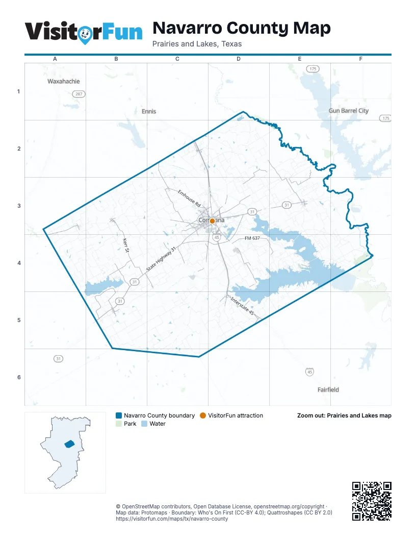
Maps inside Navarro County
1 map inside, from the street map of Navarro County down.
Street index of Navarro County
Each street on the sheet and the grid squares it crosses.
- West State Highway 31C3, B4, C4, B5
- Corsicana BypassD3, C4, D4
- East State Highway 31D3, B5
- Northwest 2nd StreetE3
- West Highway 22A3, A4
- North Business 45D3
- West State Highway 22C3
- South US Highway 287D3, D4
- West 2nd AvenueC3, D3
- West 7th AvenueC3, D3
- South 15th StreetD3, D4
- South Business 45D3
- State Highway 31B5
- Martin Luther King Jr BoulevardD3
- Southeast 0080D3
- State Highway 14D5
- South 7th StreetD3
- West Second StreetB3
- Northeast 2nd StreetE3
- North 15th StreetC3, D3
- East Forgey StreetB3
- North 7th StreetD3
- East State Highway 22C3
- South Austin AvenueD5
- East 7th AvenueD3
- West Forgey StreetB3
- T A Carroll AvenueD3
- North Austin AvenueD5
- Austin AvenueC3, D3, D5
- Connecting RoadB3, F3, C4
- Northeast 0040 RoadD3
- South Interstate 45C2, D3, D4, D5
- Northeast 3090D2, E2, E3
- FM 637D4, E4
- Emhouse RoadC3
- North Spikes RoadD3, C4, D4
- North Interstate 45D3
- FM 667B4
- West Roane RoadD3
- FM 2452C4
- North Beaton StreetC3, D3
- South FM 55B4, C4
- West 3rd AvenueC3, D3
- FM 1126C4
- Main StreetB3, C3, D4, B5
- FM 246 WestD5
- South Main StreetD3, B5
- West Main StreetD5
- North Main StreetD3, B5
- Southwest 0030C4
- FM 744C3
- East 3rd AvenueD3
- South FM 709B5
- South Beaton StreetD3
- North Fordyce StreetB3
- North Goodman AvenueE3
- South Senter AvenueE3
- South State Highway 75D5
- North Garitty StreetA3
- South Garitty StreetA3
- North Fullerton AvenueB5
- North Elm StreetB3
- North Senter AvenueE3
- Joe Johnson DriveC3
- East Main StreetD5
- Houston StreetB3, C3, D3
- Brown AvenueC4
- North 1st Street EastB5
- Farm-to-Market Road 1126C2
- North 5th Street WestB5
- North Cedar StreetA4
- FM 709 NorthB4, B5
- South Kerr StreetB3, B4
- Farm-to-Market Road 1839C3
- Southeast McKinney StreetC2, D2, D3
- Southwest McKinney StreetC2, D2, D3
- Northeast 2060D2, D3
- Grey Thompson RoadC2, C3
- Northwest 2170B4
- Northeast 0070D3
- Dobbins RoadC3
- Navarro RoadD4
- North FM 55B4
- Navarro SlabD4
- West 5th AvenueC3, D3
- Southeast County Road 1090D4
- Northeast County Road 0070D3
- Corsicana Crossing BoulevardD3
- Northwood BoulevardC3, D3
- North 45th StreetC3
- Northeast McKinney StreetC2
- Northwest McKinney StreetC2
- West 13th AvenueC3, D3
- County Road 0180C2
- Bowie DriveC3
- Southeast County Road 1200D5
- Old Highway 287E4, F4
- Drane RoadC3
- Oaklawn DriveC3, D3
- G W Jackson AvenueD3
- North 24th StreetC3
- North 37th StreetC3
- North 13th StreetC3, D3
- Calhoun StreetC2
- East 13th AvenueD3
- Hardy AvenueC3, D3
- North Gilmer AvenueB5
- South 45th StreetC3, C4
- South 12th StreetD3
- South 2nd StreetD3
- Hamilton RoadC4
- Forrest LaneC3
- South 31st StreetC3
- Northwest County Road 2004C3
- East 1st AvenueD3
- Southeast 4th StreetE3
- South 24th StreetC3
- South Fordyce StreetB3
- South 16th StreetD3
- North 12th StreetD3
- Gilmer StreetC2
- East 5th AvenueD3
- Lakeview DriveD3, E4
- Farm-to-Market Road 1603C2, D2
- North 2nd StreetD3, B5
- East Navarro StreetD5
- South Old Alma RoadC2
- East Grady StreetB3
- Northeast 1040C2, D2, D3
- Northeast 3270D2, E2
- Southwest County Road 0030C4, D4, D5
- Southwest 4170B5, C5
- Southwest 4250B5, C5
- L S Ranch RoadE2
- Northeast 2050D2, E2, D3
- Oak Grove RoadC2, E3
- Northeast 0190D2, D3
- Northeast County Road 1030C2, D2
- Northwest County Road 0010C3
- Northwest C R 4420A3, B3
- Northeast 0080D3
- Northeast 3250D2
- Northeast 1110D2
- South East 1020D4
- County Road 4250F4
- County Road 1420B3
- West Park Row BoulevardC3, C4
- Northwest County Road 4080B4
- Northwest C R 4250A4
- Northeast 2170D3, E3
- Northwest County Road 1300B3, C3
- Northwest 4050B3, B4
- County Road 4060E3, F4
- Northeast 2030D3
- Northeast 3120E2, E3
- Northeast 2120D3, E3
- Northwest County Road 4370A3, A4
- Northeast 2160E3
- Cemetery RoadC2, E3, E4, B5
- Northeast 3200D2
- Northeast 1090 RoadD2
- Southwest 2300C5
- Northeast County Road 3040E3
- Southwest County Road 0020C4, D4
- Southeast County Road 4040E3, F3
- Northeast 1060C2, D2
- Liberty DriveC4
- Southwest 4180C5
- Southeast County Road 0010D3
- Old Rankin RoadB3
- Northwest County Road 1180C3
- County Road 2230C5, D5
- Southwest 4040B5
- Northwest 4300A4
- Southwest 2320C5, C6
- County Road 2390E4, D5, E5
- Southwest County Road 3080C4
- NE3160E2
- Northwest County Road 2060C3, C4
- Southwest 4070B5
- Southeast County Road 4180F3, F4
- County Road 4120A3, E3, E4
- Northwest County Road 0120C2, C3
- Northwest 2200 RoadB4, C4
- Southwest 3090B4, C4
- Northwest County Road 1270C3
- Southeast 0210E3
- Northwest 4430B3
- Northeast 0120D3
- Northwest County Road 4010B4
- Southwest County Road 3160B5
- Southwest County Road 2090C5
- County Road 4210F4
- Southwest 3150B4, C4, B5
- Northwest 2260B3
- Southeast County Road 0040D3
- Northeast County Road 1050C2, D2
- Northwest 4210A4, B4
- Northwest 3090B4
- Southwest County Road 3130B4
- Southwest 4220C5
- Southwest 4120B5
- Northeast 3110E2, E3
- Oak Valley LaneC4
- Southeast County Road 0050D3, D4
- Southeast County Road 0070D3
- Southwest County Road 3040C4
- Northeast 0170D2, D3
- Northwest 3040 RoadB4
- Northeast 2035D3, E3
- County Road 2320E5
- Fullwood-Cockerell RoadE4
- Midway RoadE4, E5
- Old Chatfield RoadC2, D2
- Wilson School RoadE2
- Southeast County Road 3020D4
- Southwest 4310C5, C6
- Southwest 4160B5
- Northeast 2020 RoadD3
- West 4th AvenueC3, D3
- Southwest 4280C5, B6, C6
- Southeast County Road 0060D3, D4
- Northwest 2070B3, C3
- Southeast 3200E3
- Northwest 0140 RoadC2
- Northwest County Road 4030B3, B4
- Southwest County Road 2380D5
- Northwest County Road 1210C3
- Southwest County Road 3050C4
- Southeast County Road 2140D4
- South East 1080D4
- Southwest County Road 2340D5
- Northwest County Road 4020B3, B4, B5
- Northwest County Road 0110C2, C3
- Southwest 4090B5, B6
- County Road 4200F4
- Northwest County Road 1170C3
- Northeast County Road 0020D3
- Southeast County Road 1120C4
- Southwest 2305C5
- Northeast 0240D2
- Northwest 4110A3, B3
- Twin Oaks LaneD4
- Northwest County Road 2270B3
- NE2160E3
- Southeast County Road 0190E3
- Northwest County Road 3150B4, B5
- Southeast County Road 3060D4, E4
- Knight StreetD4
- Northwest County Road 1160C3
- Southwest County Road 2130D5
- Northwest County Road 1310B3
- Northeast 3010E3
- Northwest 4170A4, B4
- Southwest 3160C4, B5, C5
- Whatley DriveE4, E5
- Northeast 0200D2, D3
- Ledwell RoadD4
- Southeast 1270 RoadD5, E5
- Southwest 2250C5
- County Road 1330B3
- County Road 2200C5
- Northeast 1120D2
- West Collin StreetC3, D3
- Northeast 0180D2, D3
- Northwest 1090C3
- Northwest 4280 RoadA4
- Northwest County Road 1260C2, C3
- Southwest 1150C4
- County Road 4080E3, F3
- Northwest County Road 2170B4
- Southwest County Road 3010C4
- Lake Halbert RoadD3, D4
- Navarro Mills Lake Dam RoadB4
- Southwest 2290C5, C6
- Southwest 4230C5
- Southwest County Road 3100C4
- County Road 2380D5, E5
- Elpis RoadA3, A4
- Northwest 2280B3, B4
- Southwest 3100C4
- County Road 4220F4
- Northeast 0040D3
- Northeast 1045D2
- County Road 4150F3, F4
- Southwest 1160C4
- Southeast County Road 1230D5
- County Road 1360B3
- Northeast 3170E2
- Northeast 3220D2
- Northwest C R 4070B4
- Northwest C R 4190B4
- Shady Creek LaneD4
- Northwest County Road 3320B4
- Northeast 0220D2, D3
- Northeast 2140 RoadE3
- Northwest 4200B4
- Northwest Country Road 0185C2
- Southwest 2420 RoadD5
- Northwest County Road 2100C4
Things to do on the Navarro County map
Places on the map
- American RV Park
- Angus
- Barry
- Beaton Lake
- Blooming Grove
- C. David Campbell Field-Corsicana Municipal Airport
- Carroll Lake
- Community Park
- Corsicana
- Corsicana Country Club
- Corsicana Crossings
- Corsicana High School
- Cox Lake
- Coyote Field
- Creslenn Ranch Lake
- Daniels Lake
- Dawson
- Dawson ISD Schools
- Elliott Reservoir
- Emhouse
- Eureka
- Frost
- Goodlow
- Hoffer Lake
- Kerens
- Kerens City Lake
- Lake Dawson
- Lake Halbert
- Lake Halbert Park
- Magnolia Lake
- Mildred
- Navarro
- Navarro Mills Lake
- Oak Valley
- Powell
- Retreat
- Rice
- Richland
- Richland-Chambers Reservoir
- Streetman
Next to Navarro County
- Ennis map
- Fairfield
- Gun Barrel City
- Waxahachie map
© OpenStreetMap contributors, Open Database License, openstreetmap.org/copyright · Map data: Protomaps · Boundary: Who's On First (CC-BY 4.0); Quattroshapes (CC BY 2.0)















