

Texas map
Dickinson map
About 21,941 people live here (Census Bureau, 2024 estimate). The sheet's index lists 300 streets; Hughes Road, Gulf Freeway and Pine Drive cross the most grid squares. Also on it: Dickinson High School, Ray Holbrook Park and Barber Middle School.
Open the map (PDF, US Letter)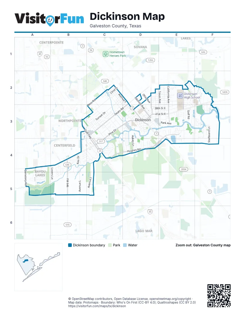
Street index of Dickinson
Each street on the sheet and the grid squares it crosses.
- Gulf FreewayB3, C3, C4
- South Gulf FreewayB3
- Pine DriveC3, D3, C4
- Highway 3D3
- 41st Street EastD3, E3
- Pine StreetD3
- Parke StreetD3
- Main StreetD3
- Galveston RoadE3, E4
- San Leon RoadF2
- Gulf Freeway Frontage RoadB3, C3, C4
- FM 646B4, B5
- Dickinson AvenueD2, D3
- FM 646 Road WestB4
- Hughes RoadE3, C4, D4, E4
- Deats RoadD2, C3, D3
- California AvenueE2, E3
- Owens DriveE2, E3
- Hill AvenueD3
- Cemetery RoadA5
- Calder DriveA4, A5
- Bay Creek DriveB4
- Sunset DriveC2, B3, C3
- Timber DriveC2, C3, D3
- Avenue JC4, C5
- Texas AvenueE2, E3
- Oak DriveC3
- Nichols AvenueD2, D3
- Avenue FC2, D2, D3
- West Hughes LaneB3, B4, C4
- Kansas AvenueD2, D3
- Avenue GC2, D2, D3
- Colorado AvenueE2, E3
- Oleander DriveD3, D4
- Avenue HC2, D3
- Avenue LB4, B5
- Winding Brook DriveE2, F2, F3
- Overland TrailE2, F2
- 37th Street EastE2, D3, E3
- 34th Street EastD2, E2
- Park AvenueD3, E3
- Country Club DriveF3
- Galveston AvenueD2, D3, E3
- Starboard LaneF3
- Forest Cove CourtC3, D3, D4
- Green Isle AvenueF2
- 39th Street EastD3, E3
- Baker DriveE2, E3
- Missouri AvenueE2, E3
- Spruce DriveC3, C4
- Frostwood CircleC3
- Lovers LaneB4, A5, B5
- 27th StreetC2, D2
- 46th StreetD3
- 32nd Street EastD2, E2
- 38th Street EastD3, E3
- Avenue IC2, D3
- Hakey LaneD3, D4
- Scenic DriveF2, F3
- Canon DriveA4, A5
- Shoreview DriveA4, A5
- 35th Street EastD2, E2
- Sherwood Forest DriveB3, C3
- Calvert LaneF3
- Ohio AvenueD2
- 31st Street EastD2, E2
- Borden Gully DriveB4
- Longshadow DriveD4
- Gum DriveF2, F3
- Nevada StreetD3
- Rodeo Bend RoadC2, C3
- 30th StreetD2, C3
- 30th Street EastD2, E2
- Dakota StreetD3
- Golf RoadE3
- Bess RoadC2
- Winding WayE3
- 28th StreetC2
- Desel DriveC4
- 45th StreetD3
- Armand DriveB4
- Ecret DriveE3, E4
- 33rd Street EastD2, E2
- 29th Street EastE2
- 36th Street EastD2, E2
- Camp Allen StreetC4
- Yupon StreetC3
- Plantation Bend StreetE3
- Pabst RoadB4, C4
- Pine Grove DriveC3
- Gill RoadC2, C3
- Old Bayou DriveC4
- Rau DriveB4
- Luhning RoadF3
- 48th StreetD3
- Whispering DriveF3
- Lobit DriveC3, C4
- Maple DriveC3
- Bayou DriveD3, D4
- Melody LaneD4
- 42nd Street EastD3, E3
- 25th StreetC2
- 26th StreetC2
- 22nd StreetC2
- Holly DriveD3
- Cedar DriveC3, D3
- Pine Oak DriveB4, B5
- Mount Vernon DriveC3
- Harbor Light DriveD3, D4
- Kellner RoadB4, C4
- North Meridian Greens DriveA4, A5
- Krueger DriveE3, E4
- West Hughes RoadC4
- 28th Street EastD2, E2
- Pecan StreetD3
- Thornwood CircleE2
- Hansen DriveB4
- Colonial DriveC3
- West Bayou DriveC4
- Illinois StreetD3
- Wagon RoadD3
- 23rd StreetC2
- East Bayou DriveE3
- 24th StreetC2
- Humble Camp RoadE3, E4
- Longwood LaneC3
- 26th Street EastE2
- Casa Grande StreetE3
- Evergreen DriveB4
- Oak Hollow DriveC3
- Holland RoadC5
- Rosewood DriveC3
- Sycamore DriveD4
- 44th StreetD3
- Oakridge DriveC3
- Houston AvenueE2, E3
- Rosewood CircleC3
- Linninger LaneF3
- 40th Street EastD3, E3
- Video StreetD3
- Olde Oak DriveC3
- Ash DriveC3, D3
- Bayou Crest DriveB4
- Meadowglen DriveE3
- Thistle DriveE2, E3
- Oakdale Mist DriveA5
- Pin Oak DriveC3
- Grand BoulevardF2, F3
- Conifer DriveB4, B5
- Fusion LaneE2
- Salvato StreetD3
- Church StreetD3
- Easy StreetD2
- Falco StreetD3
- Crest DriveC3
- Royal Oaks DriveC3
- Briar Hollow DriveE2, E3
- HollywoodD3
- Peacock Isle DriveD3
- 27th Street EastE2
- 29th StreetC2
- Palm DriveD4
- Serenity DriveB4
- 21st StreetC2
- Cranston Grove DriveA4, A5
- Cottonwood CircleE3
- Oak CourtE3
- Liggio StreetD3
- Hauna LaneE2
- Mellow LaneE3
- Parkview Terrace LaneA4, A5
- Coral Cliff DriveA5
- 43rd Street EastD3, E3
- Shady Oak LaneC3
- Misty Cliff DriveB5
- Rice RoadD4
- Tanglebriar DriveD4
- Allsseitz DriveE2
- Utah AvenueE2, E3
- Pine Shadows StreetE3
- Nottingham LaneB3, C3
- Chicago StreetD3
- Fatta DriveD3
- Old Castle LaneC4
- Nebraska StreetD3
- Bruce DriveF2, F3
- Green Willow LaneC4
- Gator DriveE3
- Meadowlark StreetC4
- Melvin Utley DriveE2
- Lighthouse LaneF3
- Reynaldo StreetB4
- Commodore DriveD4
- 47th StreetD3
- Bentwood DriveB4, B5
- Plantation DriveC3
- Ponderosa DriveD4
- Lobenstein LaneE4
- Yacht Club DriveD4
- Wood Sorrel DriveE2
- Central StreetD3
- Minnesota StreetD3
- Blue Water LaneC4
- Murry DriveE2
- Leonetti LaneF3
- Lookout LaneB4, C4
- Live Oak DriveC4
- Westwood DriveE3
- Cedar Creek DriveE3
- Cimmaron DriveD4
- Sweeny DriveC3
- 44th Street EastE3
- Riverwood DriveB4
- Victoria AvenueD3
- Basswood DriveB4, B5
- Dockrell StreetD3
- Johnson StreetE3, E4
- Saint Goar StreetD3
- Alabama AvenueE3
- Abbie LaneE2
- Mariners Mooring StreetF3
- Honeyvine DriveE2
- Cypress Meadows DriveA5
- Yupon DriveC3
- Chisholm TrailE2
- Tallow DriveC3
- Tanglewood DriveC3, C4
- Fargo DriveE2
- Briarbrook DriveE3
- Elderberry CourtD3
- Sherwood Oak DriveC3
- Inwood DriveC3
- Pecos StreetE2
- Guadalupe DriveE2
- Termini StreetD3
- Bramble LaneE2
- Jerhigan FordC2
- Red River DriveE2
- West Deats RoadC3, B4
- Shadowlane DriveC3
- Ash CourtE3
- Avenue CD3
- Meadow LaneC4
- Casa LaneD2
- Fiesta LaneD2
- Kilgarney KeepC2
- Sullivan LaneC2
- Pecan Grove DriveB4, C4
- NicoliniD3
- Benson StreetD3
- Cherry DriveC3, D3
- Oak LaneB4, B5
- Mowat DriveD3, E3
- Beatrice AvenueD3
- Legal LaneE3
- Bank StreetD3
- VenziD3
- Brentwood CoveB4
- Pine Manor LaneC4
- Woodlawn StreetC3
- Oak Park StreetD3
- Pinecrest DriveC3
- Belmont StreetC3
- Island DriveF3
- Greenbriar StreetC3
- Marcos StreetD2
- Manor LaneC3, C4
- Montana AvenueD2, D3
- East WashingtonD3
- Birch DriveC3
- Pine Oak CircleB5
- Water StreetC4
- Hilton LaneC5
- Saint Edmunds CrossingC2
- Pebble Spring DriveA5
- Bayou CircleC3
- Imite StreetD3
- Palmetto CourtB4
- Silver Bend DriveA5
- Berry Field BoulevardD3
- Bayou Bend DriveF3
- Bonanza DriveD4
- Wilmington DriveC3
- Mariner WayD4
- Amanda StreetD3
- South Meridian Greens DriveA5
- Redwood StreetC3
- Williamsburg DriveC3
- Woodland DriveC3
- Cove LaneB4
- Austin StreetD3
- Greenlee LaneC3
- Kings CourtB3, C3
- 32nd East StreetE2
- Kristen DriveD3
- Brigid CourtB5
- Elm DriveC3
- Beacon Pointe LaneA4
- Old Orchard WayC4
- Georgia AvenueE3
Places on the map
- Barber Middle School
- Bay Area Raceway
- Bonnie's Donut
- Chaparral Golf Club
- CVS Pharmacy
- Days Inn by Wyndham Dickinson TX
- Destroyer Island
- Dickinson Animal Hospital
- Dickinson Cemetery
- Dickinson City Hall & Municipal Courts
- Dickinson Fire Department & EMS Central Station
- Dickinson Fire Department Station 1
- Dickinson Fire Department Station 2
- Dickinson High School
- Dickinson ISD Administration
- Dickinson ISD Transportation
- Dickinson Police Department
- Dickinson Seafood Restaurant
- Dollar General
- Family Dollar
- First United Methodist Church Dickinson
- Heartbreaker's
- Holy Trinity Episcopal Church
- KFC
- Kroger
- McAdams Junior High School
- McDonald's
- Mt. Carmel Baptist Church
- New Jerusalem Baptist Church
- Paul Hopkins Park
- Pro Exhaust
- Public Library
- Ray Holbrook Park
- Ronnie's
- Sam Vitanza Stadium
- Shell
- Taco Bell
- Valero
- Walgreens
- Wendy's
Next to Dickinson
- Bay Colony Pointe
- Centerfield
- Centerpointe
- Firenza
- Gianni
- Lago Mar
- Lennar at Lakes in Bay Colony
- Northpointe
- Sovana
- The Lakes in Bay Colony
- The Meadows in Bay Colony
- Vittoria
© OpenStreetMap contributors, Open Database License, openstreetmap.org/copyright · Map data: Protomaps · Boundary: Who's On First (CC-BY 4.0); Quattroshapes (CC BY 2.0)















