

Texas map
Gulf Coast map
The sheet's index lists 35 highways; US 77, I-69E and US 59 cross the most grid squares. Things to do inside the boundary: 1940 Air Terminal Museum, Almeda Mall and Aransas National Wildlife Refuge. Also on it: Angleton, Aransas Pass and Atascocita.
Open the map (PDF, US Letter)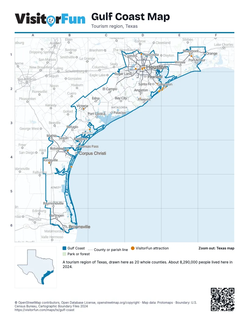
Highway index of Gulf Coast
Each highway on the sheet and the grid squares it crosses.
- I-2A6, B6
- I-10D1, E1, F1
- I-37A3, B3, B4
- I-45D1, D2, E2
- I-69C2, D1, D2
- I-69EA4, B4, B5, B6
- I-169B6
- I-610D1
- US 59B3, C2, D1, D2
- US 69E1
- US 77A4, B3, B4, B5, B6
- US 83A6, B6
- US 90D1, E1, F1
- US 96E1
- US 181B4
- US 287E1
- US 290C1, D1
- TX 6C1, D1
- BW 8D1, D2
- PR 22B4
- TX 35B4
- TX 44B4
- TX 73E1, F1
- TX 87F1
- TX 99D1, D2, E1
- TX 124E1
- TX 146D1, D2
- TX 225D1
- TX 249D1
- TX 286B4
- TX 288D1, D2
- TX 332D2
- TX 358B4
- TX 550B6
- FM 1764D2
Things to do on the Gulf Coast map
- Almeda Mall
- Aransas National Wildlife Refuge
- Artist Boat
- Bayou Bend Collection and Gardens
- Benno's Cajun Seafood
- Bishop's Palace
- Blaffer Art Museum
- Brazos Bend State Park
- Brazos Mall
- Brazosport
- Busters Old Time Photos
- Children's Museum Houston
- CityCentre
- Contemporary Arts Museum Houston
- Discover Victoria Visitor Center
- Discovery Green
- Dishman Art Museum
- Downtown Aquarium Houston
- Edward and Helen Oppenheimer Bird Observatory
- First Colony Mall
- Fort Bend Children's Discovery Center
- Galveston Duck Tours
- Galveston Helicopters
- Galveston Party Boats
- Galveston Railroad Museum
- Goose Island State Park
- Hal Newsom's Airboat Tours
- Hermann Park
- Houston Botanic Garden
- Houston Museum of Natural Science
- Houston National Cemetery
- Houston Zoo
- Japanese Garden
- Juneteenth and Beyond Guided Tours
- Katy Mills
- Kemah Boardwalk
- King Ranch
- La King's Confectionery
- LaCenterra at Cinco Ranch
- Levy Park
- Lone Star Flight Museum
- McFaddin-Ward House
- McGovern Centennial Gardens
- Mecom Fountain
- Memorial Park
- Miller Outdoor Theatre
- Molly's Pub
- Moody Gardens
- Museum of Fine Arts, Houston
- Museum of the Gulf Coast
- National Museum of Funeral History
- Nia Cultural Center
- Ninfa's on Navigation
- Old Town Spring
- Padre Island National Seashore
- Palo Alto Battlefield National Historical Park
- Pasadena Town Square
- PlazAmericas
- Rothko Chapel
- Russ Pitman Park
- Saint Anthony's Cathedral
- San Jacinto Battleground State Historic Site
- San Jacinto Monument
- Sandy Feet Sand Castle Services
- Seawall Interpretive Trail (Project SIT)
- Space Center Houston
- Spindletop Gladys City Boomtown Museum
- Texas State Aquarium
- The Bryan Museum
- The Galleria
- The Grand 1894 Opera House
- The Menil Collection
- The Strand Historic District
- Town & Country Village
- Tyrrell Park
- Varner–Hogg Plantation State Historic Site
- Victoria Mall
- Wave Dancer Charters
Places on the map
- Angleton
- Aransas Pass
- Atascocita
- Bay City
- Beaumont
- Brownsville
- Corpus Christi
- Cypress
- Edna
- El Campo
- Freeport
- Galveston
- Harlingen
- Houston
- Kingsville
- Mathis
- Orange
- Palacios
- Pearland
- Port Arthur
- Port Lavaca
- Raymondville
- Refugio
- Robstown
- Rockport
- Santa Fe
- Sinton
- Sugar Land
- Victoria
- Winnie
Next to Gulf Coast
© OpenStreetMap contributors, Open Database License, openstreetmap.org/copyright · Map data: Protomaps · Boundary: U.S. Census Bureau, Cartographic Boundary Files 2024