

Texas map
Ennis map
About 24,753 people live here (Census Bureau, 2024 estimate). The sheet's index lists 300 streets; Congressman Joe Barton Parkway, US Highway 287 and East State Highway 34 cross the most grid squares. Also on it: Lake Clark, Texas Motorplex and Bluebonnet Park.
Open the map (PDF, US Letter)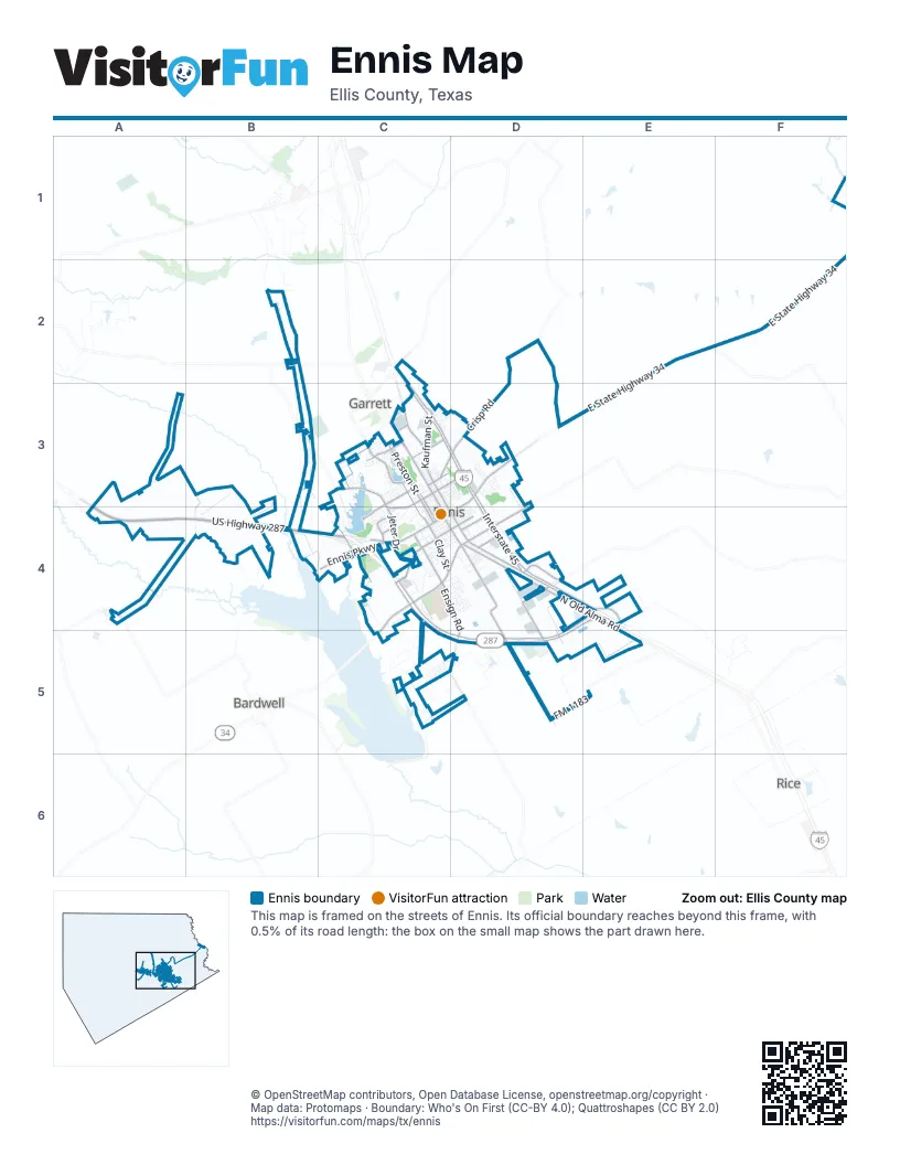
Street index of Ennis
Each street on the sheet and the grid squares it crosses.
- Congressman Joe Barton ParkwayC4, D4, E4, C5, D5
- East State Highway 34E2, F2, D3, E3
- West US Highway 287B4, C4
- South US Highway 287A4, B4, C4
- North Kaufman StreetC3, D4
- South Kaufman StreetD4
- East Ennis AvenueD3, C4, D4
- West Lake Bardwell DriveC4, C5
- West Ennis AvenueC4
- Creechville RoadD3, D4
- Lake Bardwell DriveC4, D4
- US Highway 287C4, D4, E4, C5, D5
- South Interstate 45D3, D4, E4
- North Interstate 45C2, C3, D3
- Ensign RoadC4, D4, D5
- North Preston StreetC3, C4
- West Lampasas StreetC4, D4
- Country Club RoadC3, C4
- Clay StreetC4
- Old Highway 75C3
- Jeter DriveC4
- North Sherman StreetC3, C4
- East FM 85D4
- East Martin Luther King DriveC3, D3
- South Main Street WestC4, D4
- West Gilmer StreetC3
- FM 879C2
- Crisp RoadD2, C3, D3
- South Oak Grove RoadD4, D5
- Northeast Main StreetC3, C4
- Knighthurst RoadD4
- Ennis ParkwayC4
- Baldridge StreetC3, C4
- Sleepy Hollow RoadC3
- Park StreetC3
- North Old Alma RoadD4, E4
- South Hall StreetC4
- FM 1183D5, E5
- North Clay StreetC3, C4
- Nesuda RoadB3, C4
- Sterilite DriveD4, D5
- Casa LindaC3
- Arnold StreetC3
- Yorkstown DriveC4
- National DriveD4
- East Burnett StreetD4
- East Lampasas StreetD4
- Washington StreetC3
- Old US Highway 287A4
- Rumbo RoadD4
- Northwest MainC3
- Jamestown DriveC4
- Cedar RoadC3
- Rudd RoadD5
- Knight Hurst RoadD4
- Oak Grove RoadD5
- Hall StreetC4
- North Cooke RoadB3, B4
- Lakeview DriveC4, C5
- Texas MotorplexB3, B4
- North Breckenridge StreetC3, C4
- Observation DriveC5, D5
- Old Boyce Road NorthA3, B3, B4
- Laneview DriveC4
- West Madison StreetC4, D4
- Liska RoadC5, D5
- South Paris StreetD4
- Medical Center DriveC4
- North Gaines StreetC3, C4
- Old Church RoadA3
- North McKinney StreetC3, C4
- Valek RoadD4
- West Denton StreetC3, C4
- South Carlton StreetC4
- West Milam StreetC4
- Neyland DriveC5, D5
- West Brown StreetC4
- Old Bardwell RoadC4
- North Shawnee StreetC3, D3, D4
- West Burnett StreetC4, D4
- East Milam StreetC4, D4
- Jones AvenueC3, D3
- North Dallas StreetC3, C4
- Northwest Main StreetC3, C4
- Linda DriveC3
- West Knox StreetC4
- Daffan AvenueC3
- Phillips DriveC3
- South McKinney StreetC4, D4
- South Preston StreetC4
- Old Waxahachie RoadA4, B4
- South Dallas StreetC4, D4
- East Decatur StreetC3, D3
- Ripley AvenueC3, D3
- Sonoma TrailC3, D4
- South Elm StreetD3, D4
- East Brown StreetD3, C4, D4
- East Belknap StreetC3, D3, C4
- West Belknap StreetC4
- South Cardinal StreetC3, D3
- East Denton StreetC3, D3
- Williamsburg DriveC4
- East Crockett StreetC4, D4
- West Crockett StreetC4
- Faulkner AvenueC3, D3
- West Waco StreetC4
- South Mulberry StreetD3, D4
- East Tyler StreetC3, D3
- Louise LaneC3
- Old Boyce RoadA3, B4
- South Sherman StreetC4, D4
- Shady Oaks DriveC5, D5
- West Moore StreetC3
- South Shawnee StreetD4
- Valhalla DriveC5
- West Tyler StreetC3, C4
- Woodlawn DriveC3
- Airport DriveC4
- Jack Mc Kay BoulevardD4
- Troon DriveC3
- Edgewood StreetC4
- Prachyl RoadB3
- East Waco StreetD4
- Volunteer DriveC5
- Vicksburg DriveC4, D4
- Loggins StreetC3, D3
- South Chatfield StreetC4
- Fairbanks DriveD4
- Sunset DriveC3, C4
- Odlozil LaneC4, D4
- West Linden StreetC3
- West Baylor StreetC4
- Carnoustie DriveC3
- Saint Andrew's DriveC3
- Austin DriveC3
- East Linden StreetC3
- Laurel StreetD3, D4
- Smith StreetC4
- East Freeman StreetC3, D3
- Avenue DD4
- Canterbury LaneD4
- Old Boyce Road SouthB4
- Floyd StreetC3
- Sundale StreetC3
- Grace CircleC4
- Beach RoadC5
- Lake Shore DriveC3
- Highland DriveD3
- Quinlan DriveC3, D3
- Woodcrest DriveC3
- Centennial AvenueD3
- Lakeview RoadC5
- North Sonoma TrailD3
- Brannon DriveD3
- Old Telico RoadD3
- South Sonoma TrailD3
- East Lake StreetC3
- Gleneagles DriveC3
- East Baylor StreetD3, C4
- Houston StreetC3
- East Moore StreetC3
- South Breckenridge StreetC4, D4
- Anthony DriveC4
- Oak Creek CourtC4
- Wild Flower StreetC4, D4
- Lyndale DriveC3
- Tallahassee DriveD4
- West Decatur StreetC4
- South Pecan StreetD3, D4
- South Gaines StreetC4
- South Main Street EastC4, D4
- North Paris StreetC3, D3, D4
- Creekwood CourtC4
- Savannah DriveC4, D4
- Estate DriveC3
- East Campus RoadB2
- Royse Ridge RoadC4
- Memphis DriveC4, D4
- Lady Bird StreetC4, D4
- Biloxi DriveC4, D4
- Mobile DriveD4
- South Sonama TrailD3, D4
- Ava DriveD4
- Renee StreetC3
- Mockingbird CircleC3
- Mount Vernon StreetC4
- West Plant RoadD4
- Owen StreetC4
- Fallen RoadC2
- East Knox StreetD3, C4, D4
- Lakeway DriveC4
- Tenison DriveC3
- Metropolitan AvenueC4
- Lafayette StreetC3
- Oakmont DriveC3
- Lakeside Country ClubC3
- Nichols StreetC3
- Stonebridge DriveC5, D5
- Wadley RoadC3
- Pleasant DriveC4
- Metro Park BoulevardD4
- Physicians BoulevardC4
- Abner RoadC3
- Joly StreetC4
- Princeton DriveC4
- Avenue BD4
- Knoll DriveD4
- Crestridge DriveC3
- Lumpkin AvenueD3
- East Latimer StreetC3, D3
- Munn DriveC3
- Marble RoadC4
- Bobolink DriveC3
- Inverrary DriveC3
- Travis StreetC3
- Mulberry StreetD4
- 1st StreetD4
- 2nd StreetD4
- Avenue ED4
- 3rd StreetD4
- West Lake StreetC3
- Avenue CD4
- CVS DriveD4, D5
- Farm-to-Market Road 984A4
- Mustang RoadA3
- Cody Gate 1C3
- I O O F RoadD4
- Village RoadD4
- Charleston DriveD4
- North Mulberry StreetD3
- Erwin DriveD3
- Avenue AD4
- Johnson AvenueC3
- BrombeckC3
- Watson StreetC3
- Ward StreetC5
- Baldwin LaneD4
- Plymouth DriveC4
- Autumn DriveD4
- Fantail LaneC3
- Starling LaneC3
- Birch DriveD4
- South Walnut StreetD4
- Avenue FD4
- Natchez DriveD4
- Grand View DriveD4
- Oak DriveD4
- Lakeridge DriveC4
- Krutilek CircleC3
- Ann DriveC4
- Dolfie LaneD3, D4
- East Bremond StreetC3
- Golden Spike RoadD3
- Williams CircleC3
- Ester LaneC3
- Hudson DriveC3
- Oriole StreetC3
- Blue Jay DriveC3
- Clemmons RoadB4
- Kinglet DriveC3
- East Dodge StreetC3
- Tad StreetC3
- Charlottsville DriveC4
- Christian RoadC3
- Lynn CourtC3
- Loy LaneC3
- Romans RoadC3
- 4th StreetD4
- Bluebonnet Hills DriveC3
- Shady GlenC4
- Hadley DriveD4
- Willowglen DriveC4
- Baker DriveD3
- Lexington DriveC4
- Jupiter LaneD3
- Westchester DriveC3
- Matthew DriveC3
- Bluebonnet TrailC3
- Clearview DriveC4
- Winkler StreetD4
- Meriott StreetC4
- Red Oak StreetC3
- Meadow Glen DriveC5
- Pebble Beach DriveC3
- Jonah LaneC3
- Sherwood DriveC4
- Oak Hills DriveC3, C4
- Prestwick DriveC3
- Terrytown DriveC3
- Caesar StreetC4
- Carrick DriveC5
- Hillcrest AvenueC3
- Arleta LaneD3
- Nellie StreetC4
- Loma Alta LaneD3
- Chapin LaneD4
- Cooper LaneD3
- Cherry LaneC3
- West Haywood StreetD4
- Tuxford DriveD4
Places on the map
- Bethlehem Batpist Church
- Blue Beacon
- Bluebonnet Park
- Braum's
- Bright & Morning Star Baptist
- Bubba’s Barbecue
- Buc-ee's
- Chick-fil-A
- Chili's
- CK Customs
- Comfort Suites
- Cotton Patch Cafe
- David S Crockett Childhood Center
- Days Inn
- Dorie Miller Intermediate School
- East Side Church of Christ
- Ennis Ford
- Ennis High School
- Ennis Memorial Cemetery
- Ennis Municipal Airport
- Ennis Post Office
- Ennis Regional Medical Center
- Ennis Veterinary Clinic
- Exxon
- Exxon Car Wash (Inc. Short-Visits)
- Fairview Park
- Jaycee Park
- Kachina Prairie Park
- Kiwanis Park
- Lake Clark
- Lake Clark Park
- Lions Park
- Lions Stadium
- Myrtle Cemetery
- North Kaufman Street
- Old City Lake
- paddock
- Saint Joseph Cemetery
- Texas Motorplex
- Walmart Supercenter
Next to Ennis
- Bardwell
- Garrett
- Rice
© OpenStreetMap contributors, Open Database License, openstreetmap.org/copyright · Map data: Protomaps · Boundary: Who's On First (CC-BY 4.0); Quattroshapes (CC BY 2.0)















