

Texas map
Forney map
About 38,572 people live here (Census Bureau, 2024 estimate). The sheet's index lists 300 streets; West US Highway 80, FM 740 and East US Highway 80 cross the most grid squares. Also on it: Forney Community Park, Amazon FTW5 and Forney High School.
Open the map (PDF, US Letter)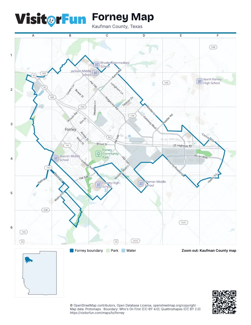
Street index of Forney
Each street on the sheet and the grid squares it crosses.
- West US Highway 80A2, B2, B3, D4, E4, F4
- Ridgecrest RoadC2, C3, D3
- North Gateway BoulevardD3, E3, E4
- East US Highway 80B3, C3, C4, D4
- College AvenueB3, B4, C4, C5
- FM 740B1, B2, C2, A4, A5
- South FM 548C4, B5, C5
- North FM 548C3, D3, C4
- South Gateway BoulevardE4
- East Broad StreetB3, B4, C4
- Pinson RoadB2, C2, B3
- South Bois d'Arc StreetB3, A4, B4
- West Broad StreetB2, B3
- FM 1641C4, D4
- Walnut LaneB5
- FM 548D2, D3
- Clements DriveA2
- Windmill Farms BoulevardF4
- FM 741C5
- North Bois d'Arc StreetB3
- Ridge Crest RoadC2
- Akron WayE4, F4
- Ranch RoadC1, C2
- County Road 212D4, E4
- Lovers LaneB2
- Reeder RoadD3, E3, D4
- Monitor BoulevardC4, D4, C5
- Bellagio ParkwayC5
- Helms TrailF4, F5
- Concord DriveE3, F3, F4
- South Chestnut StreetB3, B4
- Iron Gate BoulevardE3, E4
- North Chestnut StreetB3
- Pecan LaneA4, B5
- Rogers ParkwayC4
- Innovation BoulevardB1, C1, C2
- Longhorn LaneC2, C3
- Redbud DriveB2, C2, C3
- Bowie StreetB2, C2, C3
- Heritage Hill DriveB2, C2
- East Main StreetB3, B4, C4
- Inspiration WayC1, B2, C2
- East Church StreetB3, B4
- Reeder LaneD3, D4
- Trailhouse LaneC3
- Spruce TrailB4, B5
- Holly Leaf TrailB4, C4
- Deacon DriveC2, D2, C3
- Main StreetA3, B3
- Elm StreetB3
- Chestnut TrailB4
- East Aimee StreetB3, C4
- Prairie MeadowE4, F4, E5
- East Buffalo StreetB3, C3
- Painted TrailC3
- Gail Wilson WayB1
- Acadia LaneC2
- Southlake DriveB2, C2
- Industrial DriveC3
- SummerhavenB3, C3
- Aspenwood TrailB4
- Warbler DriveB5
- Glenwood TrailC1, C2, D2
- Chinaberry TrailB4
- Stanford StreetB3, B4, C4
- South Center StreetB3, B4
- Kaufman StreetB3, C3, C4
- Hillside DriveB1, B2
- Sierra ParkwayF4
- Cedar StreetB3, C3
- Greyhawk DriveB5
- Woodcrest WayB2, C2
- North McGraw StreetB3
- Carl C Senter StreetB2, C2
- West Trinity StreetB3
- Gold Finch LaneB5, B6
- Estate LaneB2
- Little Gull DriveB5
- Meadow LaneC2, C3
- Eagle RidgeC3
- York StreetB2, C2
- Plantation RidgeF4
- Prairie Lakes LaneE5, F5
- Tumbleweed DriveC2
- Sycamore TrailB4, B5
- Forestwood DriveB2, C2
- Wolf DriveC2
- West Pacific StreetB3
- Justice Center DriveC4
- Altuda DriveC4, D4
- Cedar Elm TrailB4, B5
- Havenrock DriveD3
- Lone Hill LaneD4, D5
- Starlight DriveC2
- Fox Hollow BoulevardC4
- Harmony AvenueB2
- Diamond Creek DriveD2, D3
- Brazos StreetB2
- Highland Prairie LaneE5
- Mustang BoulevardC3
- Pinewood TrailB4
- Van Buren DriveC3
- Paige LaneB2
- Freedom TrailC2
- Lakewood TrailB4
- Don T Cates DriveD3
- Long Prairie DriveC2
- Glendon DriveB5
- Marketplace BoulevardC3
- Princeton CircleB4
- Rambling WayC2
- Bonham DriveC2, D2
- Valley ViewC1
- Wildwood BoulevardC3
- Wandering DriveC2, C3
- Pecan Ridge DriveC2, D2, C3, D3
- Longhorm LaneC2
- Arbury DriveC3
- Ardsley LaneD2, D3
- Azalea DriveC2
- Cypress Hollow DriveE3, E4
- Giddings TrailC3
- WindsorB4
- Park Creek AvenueC3
- Carmen StreetB5
- Cisco TrailC3
- Kelli DriveB2
- Madrone TrailB4, B5
- Lonesome Dove LaneC3
- North Bois d’Arc StreetB3
- Independence TrailC2
- Border StreetB3
- Burgett StreetB3
- Magnolia DriveC2
- Regal DriveC3, C4
- West Shands StreetB3, B4
- Amherst DriveB4
- Industrial ParkD4
- Wrangler AvenueB3, C3
- Dalview DriveA4, B4
- Chapel Hill DriveC4, D4
- Mallard DriveB5
- Highspire DriveC3, D3
- Brandon LaneB1, B2
- Kings Canyon StreetC2
- Whaley DriveD2, D3
- Martins Pond RoadD2
- Old Glory LaneC2
- Kings Court DriveB3
- Singletree DriveF4
- Mercy StreetB5
- Anns WayC4, D4
- Tuscany DriveD2
- East Brooks StreetB3, B4
- Patriot ParkwayC2
- Canary LaneB5, B6
- Oak StreetB3
- Rocking Hills TrailE3
- Stone StreetB2
- Marlee DriveD3
- East Forestwood DriveC2
- Overton DriveC2, D2
- Lauren Grove LaneB5
- Wenham WayD4, D5
- Dancing Waters AvenueC4
- Woods RoadC4
- Bayberry TrailB4
- Antler TrailC2
- Currency CircleD4
- Vista Ridge DriveD3
- Bloomsbury LaneD3
- Villanova CircleB4
- East Shands StreetB4
- West Buffalo StreetB3
- Dogwood TrailB2
- Truchas AvenueD4
- Cherrytree TrailB4
- Kroger DriveC3
- Laguna Vista DriveC5
- Cassandra DriveB2
- North Center StreetB3
- Mandarin StreetB5
- West Aimee StreetB3
- Marble Falls DriveE3
- Hickory Park LaneC4
- Leafy Glade RoadC4, D4
- Cole StreetB2
- Trophy TrailC4
- Doe Meadow LaneC2
- Bugle Call RoadC4
- Fairfield DriveD2, D3
- Beacon Hill LaneC4
- Cornell DriveB4
- Chesapeake DriveC2, D2
- Elmwood TrailB4
- Hazelnut TrailB4
- Conchas DriveD4, D5
- Redford LaneC4, D4
- Austin StreetB3
- Industrial WayD3
- White Porch AvenueC4
- South Profit RowD4
- Sparrow DriveC2, C3
- Pheasant LaneC4
- Landsdale CircleC2
- ColgateB4
- Lowrance AvenueB3, B4
- Sandpiper DriveB5, B6
- Woodford DriveC5
- Hackberry TrailB4
- Blanco DriveC2
- County Road 225A2
- Locust StreetB3
- East Pacific StreetB3
- Ponderosa DriveC2
- Alexander StreetB3, C3
- Blue Jay WayB6
- Archer WayC2
- Willow LaneC2
- Cardinal DriveC3, D3
- Pennridge DriveC3
- Delaford DriveC3
- Tenor DriveB2
- Berry TrailC2
- Classic LaneD4
- Fox Glen DriveC2
- Basswood TrailB4
- Boxwood TrailB4
- Amesbury DriveD4
- Joshua Tree CourtC2
- Sweetgum TrailB4
- Appaloosa DriveC2
- Mulberry StreetB4
- Red Oak CourtB4
- Rockbrook DriveC2
- Colt DriveC2
- Granite Rock TrailE3
- Pinto LaneC2
- Woodberry DriveC3
- Caladium DriveC3
- Bur Oak TrailB4
- Robin LaneC2
- Symphony AvenueB2
- Timber RoadC4
- Soprano DriveB2
- Redwood CourtC2
- Red Hawk LaneB5
- Florence DriveC5
- Lightning TrailC2, C3
- Centenary DriveB4
- North Profit RowD4
- Anthem LaneB2
- Bermuda StreetB2
- Coronado CourtC5
- Glen Hollow TrailB4
- Alpine StreetB2
- Jason DriveB2
- Spinnaker DriveC4
- Monument DriveC2
- Parkside RoadC4, D4
- Ashbrook TrailB4
- Concord StreetB2
- Oak Ridge RoadC4
- Nederland WayC4
- Park Manor AvenueC3
- Darcie DriveB2
- Persimmon TrailB4, B5
- Chelsea LaneE3, E4
- Royal StreetB2
- Allegro AvenueB2
- Downing StreetB2
- Sequoia DriveC2, D2
- River Birch TrailB4
- Cherrywood TrailB4
- Hunters CircleC3
- Haggetts Pond RoadD2
- PurdueB4
- West Main StreetB3
- Branch StreetC2
- Thunder TrailC2
- Trailblazer RoadC2
- Vassar StreetB3, B4
- Monument Hill DriveC2, D2
- Westminster DriveB4
- Black Oak TrailB4, B5
- Kings Canyon CourtC2
- Eagle Nest AvenueC4
- Houston StreetB3
- Mimosa TrailB4
- Hampton DriveE4
- Westlake DriveC4
- Creekwood TrailB4
- Chaco DriveC2
- County Road 217D3, D4
- Goliad TrailC4
- Hound Hollow RoadC4
- Mesquite StreetB3, C3
- Douglas StreetB3, B4
- East Pine StreetB3
- Manassas DriveF3, F4
Places on the map
- 7-Eleven
- Aldi
- Alfredo's Steak House
- Amazon DDX7
- Amazon FTW5
- AMC CLASSIC Forney 12
- American National Bank of Texas
- Animal Medical Center of Forney
- Antiques & Vintage Texas
- Applebee's
- Armstrong's Transmission Spec
- Automax Forney
- AutoZone
- Bank of America
- Blackburn Elementary School
- Cadence Academy Preschool
- City Plaza
- Claybon Elementary School
- Costco
- Criswell Elementary School
- Crosby Elementary School
- Forney Community Park
- Forney High School
- Henderson Elementary School
- Hillcrest Cemetery
- Jackson Middle School
- Johnson Elementary School
- Kickapoo Trade Center
- Lowe's
- Mulberry Park
- Mustang Crossing at Forney
- Shafer Plaza at Mustang Creek
- Summerhaven Mobile Home and RV Park
- The UPS Store
- Themer Middle School
- Walmart Supercenter
- Warren Middle School
- Wilson Elementary School
© OpenStreetMap contributors, Open Database License, openstreetmap.org/copyright · Map data: Protomaps · Boundary: Who's On First (CC-BY 4.0); Quattroshapes (CC BY 2.0)















