

Texas map
Kaufman County map
About 197,829 people live here (Census Bureau, 2024 estimate). The sheet's index lists 300 streets; South FM 148, East US Highway 175 and South State Highway 34 cross the most grid squares. Things to do inside the boundary: Terrell and Texas Zoofari Park.
Open the map (PDF, US Letter)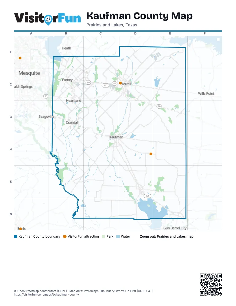
Maps inside Kaufman County
2 maps inside, from the street map of Kaufman County down.
Street index of Kaufman County
Each street on the sheet and the grid squares it crosses.
- Ronald Reagan Memorial HighwayB2, D2
- East US Highway 175C4, D4, D5, D6, E6
- West US Highway 80B2, C2
- South State Highway 34C4, D4, B5, C5
- East Mulberry StreetC4, D4, E4
- State Highway 34 NorthD1, E1, D2
- North State Highway 34D2, D3, D4
- State Highway 205C1, C2
- State Highway 274D5, D6
- State Highway 34 SouthD2
- West Moore AvenueC2, D2
- South Virginia StreetD2
- FM 148C2
- North 3rd StreetE1, C5, E6
- US Highway 175 Service RoadD5
- East Moore AvenueD2
- South 3rd StreetC4, C5, E6
- Ed Hall DriveC4
- West Grove StreetD2, C4
- South State Highway 274D5
- Terrell HighwayD4
- North State Highway 274D5
- North Washington StreetC4
- North Jackson StreetC4
- West Mulberry StreetC4
- East State Highway 34B5
- South FM 148B3, B4, C4, C5, C6, D6
- West US Highway 175B3, C3, C4
- Farm-to-Market Road 1836D4, E4, E5
- North FM 148C2, B3, C3
- Farm-to-Market Road 90E5, E6
- FM 740B1, B2, B3
- FM 741B2, B3
- Windmill Farms BoulevardC1, C2
- FM 548C1, B2, C2
- FM 1641B2, C2, C3
- FM 2451B5, C5
- Airport RoadD2
- Ridgecrest RoadB2
- East US Highway 80B2
- Farm-to-Market Road 1389B3, B4
- North Gateway BoulevardB2, C2
- South Gateway BoulevardB2, C2
- College AvenueB2
- Kaufman StreetB2, B3, B5
- US Highway 175B3
- South Washington StreetC4
- Farm to Market Road 3486D1
- South Houston StreetC4
- Lawson RoadB2
- FM 3039B3
- South FM 548B2
- Walnut LaneB2
- North FM 548B2
- North Frontage RoadB3
- South Elm StreetD5
- Farm-to-Market Road 1565D1
- East Broad StreetB2, D2
- West Mason StreetE6
- Pinson RoadB2
- Clements DriveB1, B2
- East Malloy Bridge RoadB3
- East Mason StreetE6
- South Bois d'Arc StreetB2
- North Virginia StreetD2
- Rand RoadC4, D4
- East Church StreetB2, B3
- East Interstate 20D2
- East 9th StreetC4, D5
- North Elm StreetD5
- West Broad StreetB2
- North Rockwall AvenueD2
- South 4th StreetB3, E6
- West State StreetD2
- Poetry RoadD2
- East Temple StreetD2, C4
- Wilson RoadD2, D3
- West Lewis StreetB3
- College StreetD2, B3
- North Jefferson StreetC4
- South Highway 175B3
- West Pyle StreetC4
- North Bois d'Arc StreetB2
- East Lewis StreetB3
- Temple StreetC4
- Ridge Crest RoadB2
- FM 2578C2, D2, C3, C4
- Colquitt RoadC1, C2, D2
- Kaufman RoadD3
- County Road 4061C5, D5
- County Road 151C4, D4, D5
- Hiram RoadE3
- Akron WayB2, C2
- FM 3094C5, C6
- Wildcat TrailB3
- Helms TrailB2, C2
- Farm-to-Market Road 1391E5
- Farm-to-Market Road 1390C4
- FM 2757B2, B3
- FM 2932B2, B3, C3
- County Road 4104C3, B4
- Ranch RoadB1, B2
- County Line RoadD6
- Griffith AvenueC2, D2
- Reeder RoadB2, C2
- County Road 309D2
- University DriveB1, C1, C2
- Travis Ranch BoulevardB1
- FM 2965E3
- Hometown BoulevardB3
- County Road 4006E6
- Lake Ray Hubbard DriveB1
- County Road 4031D5
- Falcon WayC2
- Frontage RoadC2, D2
- County Road 4023D5
- Railroad StreetB5
- Evans RoadB3
- Main StreetB2, D2, C4, B5
- 9th StreetD2, E6
- County Road 212B2, C2
- Iron Gate BoulevardC2
- Spur 557 Frontage RoadC2
- Old Kemp HighwayD5
- Tabor ParkwayC4
- Monitor BoulevardB2
- North Frances StreetD2
- West Fair StreetC4
- South Rockwall AvenueD2
- Heartland ParkwayB2, B3
- FM 148 BypassB3
- Lovers LaneB2, D2
- Oak Creek DriveC4
- Rosehill RoadD2
- Spring Creek BoulevardB3
- Ravenhill RoadB2
- East I-20 Access RoadE3
- I-20 East Access RoadD2, E3
- Rogers ParkwayB2
- Bellagio ParkwayB2
- Concord DriveC2
- Town North DriveD2
- South Adelaide StreetD2
- County Road 177D2
- Lakemont DriveB2
- Pecan LaneB2
- North Main StreetB3, D5
- South Main StreetB3, D5
- College Mound RoadD2
- Windsor AvenueD2
- East High StreetD2
- Industrial BoulevardD2
- East Fair StreetC4, D4
- East 1st North StreetC4, D4
- South Commerce StreetD5
- Devonshire Drive NorthB2, C2
- Governors BoulevardB1
- Tolosa RoadD5
- County Road 4024D5
- I 20 West Access RoadD3
- Devonshire Drive SouthB2, C2
- FM 1390C4
- Abbeygreen RoadB1, B2
- Ola RoadD4
- East State StreetD2
- Bradshaw StreetD2
- Stevens RoadB1
- King RoadB1
- East Arcadia RoadD5
- South Chestnut StreetB2
- County Road 326D1
- Bethlehem StreetD2
- West Interstate 20C2
- West High StreetD2
- Old Kaufman RoadD5
- South Jesse Lee StreetD5
- East Scyene RoadB2
- North Shannon StreetC4
- Las Lomas ParkwayC2
- East Alamo StreetD2
- East Trunk StreetB3
- South Old Rail RoadD4
- Interstate 20B2
- North Chestnut StreetB2
- West Main StreetB2, B3
- West University StreetD2
- Dellis StreetD2
- Gardner StreetD2
- West 9th StreetC4, D5
- West 4th StreetC4, D5
- Arcadia RoadD5
- West Alamo StreetD2
- Harbor Point RoadE6
- County Road 2326D1
- West First North StreetC4
- Mayfield StreetD2
- Commerce StreetD5
- Farm-to-Market Road 3094C5
- West 17th StreetD5
- East University StreetD2
- North Houston StreetC4
- County Road 2316D1
- County Road 346E1, E2
- County Road 4017D5, E5
- Abner RoadD3
- County Road 4072C6
- Bilindsay RoadB4, B5
- County Road 109E4
- County Road 146D4, D5
- County Road 279C3, D3
- County Road 243C1, D1
- County Road 120E3, E4
- County Road 314E2, E3
- County Road 4084B5, C5
- County Road 103D3, D4, E4
- County Road 4015E5
- County Road 4027D4, D5
- County Road 4028D5, E5
- County Road 331E1
- County Road 283C3
- County Road 4076C5, C6
- County Road 301D2, D3
- County Road 4052D6
- Valley ViewB1, B2
- County Road 313E2, E3
- County Road 110E4
- County Road 4057C6, D6
- County Road 349E2
- County Road 352E2
- County Road 4083C5
- Fair RoadC4, D4
- County Road 4060C5, C6
- County Road 4058C5, D5, D6
- County Road 245C1, D1
- County Road 116E4, E5
- Shady LaneC4, C5
- County Road 121E3, E4
- County Road 104E4
- County Road 4062C5
- County Road 4095C4
- County Road 4075B6, C6
- County Road 4056D6
- County Road 4116B4, C4
- Tarlton RoadE6
- County Road 133D3, E3
- County Road 4020E6
- County Road 4055D5, D6
- County Road 347E2
- County Road 4098B4
- County Road 4090B4, C4, B5, C5
- County Road 344E1, E2
- County Road 4068C6
- County Road 277C3
- County Road 4036D5
- County Road 324D1
- County Road 305C2
- County Road 4074B6, C6
- County Road 308D2, E2
- County Road 136D2, D3
- Taylor Ranch LoopD5
- County Road 4077C5
- County Road 115D4, E4
- County Road 118E4
- County Road 312E2, E3
- Cartwright Ranch RoadD4
- County Road 4065C6
- County Road 4106C3, C4
- County Road 353D2, E2
- County Road 213C2
- Knoxbridge RoadB2
- County Road 236C2
- County Road 108E4
- Samuels RoadC1, C2
- County Road 348E2
- County Road 112E4, E5
- Canyon Lake RoadE3
- County Road 339E1
- County Road 304C2, D2, C3
- Murphy CrossingE5
- County Road 335E1
- County Road 316E2
- Star Brand DriveC4
- West Alamosa DriveC2, C3
- County Road 261B3, C3
- County Road 4096B4, C4
- County Road 249D1
- County Road 125E3
- County Road 119E4
- County Road 4011E5
- Farr Altom RoadB4
- County Road 323D1
- County Road 329E1
- County Road 101D3, D4
- Innovation BoulevardB2
- County Road 321D1
- County Road 4066C6
- Sundown DriveD4
- County Road 355D1, E1, D2, E2
- County Road 302C3, D3
- County Road 341E1, E2
Things to do on the Kaufman County map
Places on the map
- Airpark East
- Amazon FTW5
- Ben Gill Park
- Buc-ee's
- Club Lake
- Combine
- Cottonwood
- Crandall
- Crandall High School
- Crossroads at Terrell
- Daugherty Lake
- Falcon Equestrian Center, LLC
- Forney
- Forney Community Park
- Forney High School
- George Watts Memorial Park
- Grays Prairie
- Heartland Park
- Hugghins Lake
- Jackson Middle School
- Kaufman
- Kaufman City Lake 1
- Kaufman City Lake 2
- Kaufman Lake
- Kemp
- Mabank
- Murphy Lake
- New Terrell City Lake
- Oak Grove
- Oak Ridge
- Post Oak Bend City
- Rosser
- Rusted Rail Golf Club
- Scurry
- Talty
- Tawakoni Balancing Reservoir
- Terrell
- Terrell Municipal Airport
- Terrell State Hospital
- Texas DPS Region 1
Next to Kaufman County
- Balch Springs map
- Ennis map
- Gun Barrel City
- Heath map
- Mesquite map
- Seagoville map
- Wills Point
© OpenStreetMap contributors, Open Database License, openstreetmap.org/copyright · Map data: Protomaps · Boundary: Who's On First (CC-BY 4.0); Quattroshapes (CC BY 2.0)















