

Texas map
Henderson map
About 13,485 people live here (Census Bureau, 2024 estimate). The sheet's index lists 300 streets; Highway 79, SH 64 and Kilgore Drive cross the most grid squares. Also on it: East Texas Multi-Use Facility, Fair Park and Henderson High School.
Open the map (PDF, US Letter)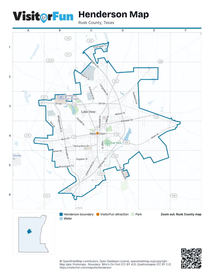
Street index of Henderson
Each street on the sheet and the grid squares it crosses.
- Highway 79D3, D4, C5, D5, B6, C6
- SH 64A3, B3, C3, D3
- Kilgore DriveC1, C2, D2, D3
- US Route 259D4, D5
- Landon Alford LoopA3
- East Main StreetC4, D4, E4, F4
- West Main StreetA4, B4, C4
- North Van Buren StreetB3, C3, C4
- Jacksonville DriveC5, B6, C6
- South Main StreetC4, C5
- North Main StreetC4
- West Depot StreetC4
- North Marshall StreetD2, C3, D3, C4
- Webster DriveD3, E3, C4, D4
- South Evenside StreetB4, B5, C5, C6
- North Evenside StreetB3, B4
- North Mill StreetD3, C4
- Richardson DriveB4, C4
- Millville DriveD2, D3
- Old Nacogdoches RoadC5, C6
- East Depot StreetC4
- Old Churchill RoadE3
- West Fordall StreetB3, C3, C4
- Elm StreetB3, B4
- Longview DriveC2, C3, D3
- Whippoorwill StreetB3, B4
- Slaydon StreetB5, C5
- Morris StreetB2, C2
- Wilson StreetC3, D3
- Industrial DriveC2, C3
- West Elk StreetB4, C4
- Gray StreetB3, B4
- Hubbard DriveD2, D3
- Jones StreetB4, B5
- Redbud StreetC3, D3
- North High StreetC3, C4
- Pine StreetC5
- Shawnee TrailB5, C5
- South High StreetC4, C5
- South Marshall StreetC4, C5
- Briarwood TrailB5
- Fair Park DriveC4, D4
- East Ragley StreetC4, D4
- Cherokee TrailC1
- Highland DriveC2, C3, D3
- Lake Forest ParkwayB3, C3
- Sand AvenueB3, C3
- Old Longview RoadC1, C2
- Glendale AvenueC5
- Rayford RoadC5, C6
- Price StreetB4
- College AvenueD4, C5, D5
- Pinehill RoadD4, D5
- Stadium StreetC4, C5
- Lion StreetC5
- Mockingbird LaneB4
- North Broadway StreetD4
- Westwood StreetB5
- Garden LaneC2
- Webb StreetB4, B5
- McMurray RoadB5
- South Alta Vista StreetB4, B5
- Aspin StreetB4
- Cedar StreetB4
- Van Sickle StreetC4, D4
- Jenkins StreetC3
- South Van Buren StreetC4
- South Standish StreetC4
- Taylor DriveC2, D2
- Lone Oak StreetB4, B5
- Crosby DriveC2
- Woodbox DriveE2
- Choctaw TrailC1
- Beverly AvenueB5
- Smith StreetC5
- East Elk StreetC4, D4
- Pecan Creek DriveE5
- Dogwood StreetB4
- Cypress StreetB4
- North Alta Vista StreetB4
- North Morningside AvenueB4
- North Spring Valley RoadB4
- North Jackson StreetC4
- Inwood Oaks StreetC2
- Austin AvenueC2
- Shawnee StreetC5
- Monroe StreetB4
- Lewis StreetE3, E4
- Alberta AvenueB6
- Colonial StreetD3
- South Oak StreetD4
- Sunset AvenueC5
- South Frisco StreetB4
- Ravenwood StreetB4
- Ruby StreetC4, C5
- Peach StreetD4
- Jola AvenueD3
- Johnson DriveC5
- West Ragley StreetC4
- Zeis BoulevardD3
- Truman DriveD4
- Village StreetC5
- McNee DriveC4, D5
- Duncan DriveC5
- Birch StreetB4
- Peterson LaneC5, C6
- Young StreetC5
- Collins StreetC5
- Forrest StreetC5
- Wylie StreetD2, D3
- Cleaver StreetC3
- Bell StreetE3, E4
- Robertson BoulevardD3, D4
- Ramblewood DriveF3, F4
- Mc Allen StreetB5
- Baker StreetC2
- Jonell StreetC5
- Meadowbriar StreetB5
- Tate StreetB4, B5
- Southview DriveB6
- Worth StreetC5
- Foley StreetB5
- Parnell DriveE4
- Christian DriveC3, C4
- Cindy Lou LaneB5
- Pope StreetD3
- Wood Lawn StreetD3
- Waskom StreetC4
- Ashby StreetD4
- Hillview DriveC1
- North Oak StreetD4
- Millard StreetC2
- West Minden StreetC4
- Dallas StreetD4
- Kaylee StreetC5
- McClarty StreetD4
- Rogers StreetC5
- Ivy StreetB3, B4
- Hillcrest StreetC3
- Margaret AvenueC5
- Yandle DriveE4
- Zion StreetD3, D4
- Laurinda StreetC5
- Kaynell DriveB6, C6
- Boren StreetC4, C5
- Blacknall DriveC2
- Hollister StreetB5
- Laylon StreetC3
- Gene StreetC3
- Tatum StreetC3
- Timberline StreetC5
- Honeysuckle StreetD3
- East Collins StreetC5
- Christian StreetC3
- Pamela StreetC5
- Timothy StreetB5
- Arnold StreetD4
- Ridglea LaneC1, C2
- West Collins StreetC5
- Bess StreetB4, B5
- Hamlett StreetC2
- Russell StreetB4, C5
- Kenswick DriveB5
- North Winterbrook StreetC2
- Rusk Co Rd 309WA3
- Loch Haven StreetB4
- South Calhoun StreetC4
- Alford Dairy RoadB3
- Overton StreetC3
- Sundown TrailC4, D4
- Brick Plant StreetC2
- Buford LaneD3
- South Winterbrook StreetC2
- Waldrop StreetE3, E4
- Parkview DriveD3, D4
- Biggers StreetC3
- East Fordall StreetC4
- Maple StreetC5
- Wagoner LaneA4
- Watley StreetD3
- Lone Star StreetD3
- Bellaire DriveC5
- Fairpark AvenueC4
- Castlegate StreetB4
- Inglewood StreetB4
- Oaklawn DriveD4
- Evans StreetC5
- Gerald StreetC4
- Clay StreetC3
- North Calhoun StreetC4
- Regent StreetC2
- South Mill StreetC4
- Pinedale StreetC4
- Ballow StreetB4
- Paige StreetD3
- Raymond StreetC4
- Marie StreetD3, D4
- Crim StreetB4
- East Lakeview DriveC3, D3
- Hays StreetD3
- Charles StreetC2
- Dobbs StreetD4
- Walnut StreetC5
- Oliver StreetD3
- Reedy StreetD3, D4
- Lowrie StreetE4
- Pruitt StreetC2, D2
- Suzy LaneD3
- Harkless StreetD3
- Brown StreetD3, D4
- Penbrook DriveB5
- Rosebrook DriveB5
- Caddo StreetC1
- West Heights StreetB3
- Campus StreetC4
- Evergreen StreetC2
- Centre CourtB4
- West Lakeview DriveC3
- North Heights StreetB3
- Private DriveC4
- Katy StreetB5
- Hubbard StreetD3
- Carver StreetC3
- Plum StreetD3
- West Lake DriveB3
- Cherry StreetD3
- Broadway StreetD3, D4
- Belvedere StreetC3
- Woodhaven DriveE2
- Saint Paul StreetC5
- OhioC3
- Wood StreetD3
- Tipps StreetC4
- Travis StreetC5
- Elaine StreetC4
- Billy Goat LaneC4
- Summer StreetD4
- Marilyn DriveC2
- West Redoak StreetC5
- Winter StreetD4
- Dean StreetB4
- Lee StreetB4
- Bradford StreetF3, F4
- Kellifield DriveB5
- Allen StreetB3
- County Road 407B6
- Holly StreetD4
- Fair Park AvenueC4
- Yale StreetD4
- SilveyC2
- Town East RoadF4
- South Jackson StreetC4
- Joseph StreetC5
- Bunyon StreetC3, D3
- Brenda LaneD3
- Church StreetB4
- Bryanhurst DriveB5
- Westview DriveB5
- Julie StreetD4
- Alabama StreetC1
- Penn StreetD4
- Clayton LaneE3, F3
- Flanagan StreetD3
- North Frisco StreetB4
- North Harriett StreetC4
- Burnett StreetD4
- Hodge StreetB4
- Billy Bob StreetD4
- Jan StreetC5, D5
- Shady Creek CircleB4
- Annie StreetB4
- Rook PlazaC5
- South Harriett StreetC4
- East Van Sickle StreetC4
- Kenneth StreetF4
- East Charlevoix StreetC4
- East James StreetC4
- East Minden StreetC4
- Magnolia StreetC5
- Reed StreetC4
- South Texas StreetC4
- Linco RoadC2
- BradfordF3, F4
- East Howard StreetC4
- HemlockB4
- Lobb StreetC4
- Shady Lake CircleB4
- Ball StreetC5
- Edgebrook StreetB4
- West Charlevoix StreetC4
- Camp StreetC4
- East Stone StreetC4
- Sweetgum StreetB4
- Clearbrook StreetB4
- South Katherine StreetC4
- East Mary StreetC4
- Emma StreetD3
- Thompson StreetC3
- Elizabeth StreetC4
- Hickory StreetD4
Places on the map
- Aaron's
- AutoZone
- Baseball Field
- Baymont Henderson
- Brass Star Cafe
- Budget Inn
- Chicken Express
- CVS Pharmacy
- Denny's
- Depot Museum
- East Texas Multi-Use Facility
- Factory Connection
- Fair Park
- First Christian Church
- Henderson City Cemetery
- Henderson High School
- Henderson Middle School
- Henderson Police Department
- Hibbett Sports
- Holiday Inn Express & Suites
- Jalapeno Tree
- Kroger
- Lake Forest
- Lake Forest Park
- Lakewood Memorial Park
- Little Caesars
- Lowe's
- McDonald's
- Motel 6
- Panda Express
- petsense
- Plaza 3 Cinema
- Rusk County Courthouse
- Rusk County Sheriff's Office
- Shell
- Sherwin-Williams
- Skate Park
- UT Health - Henderson
- Willow Lake
- Yates Park
© OpenStreetMap contributors, Open Database License, openstreetmap.org/copyright · Map data: Protomaps · Boundary: Who's On First (CC-BY 4.0); Quattroshapes (CC BY 2.0)















