

Texas map
Rusk County map
About 53,391 people live here (Census Bureau, 2024 estimate). The sheet's index lists 300 streets; US Route 259, Farm-to-Market Road 1798 and Hill Street cross the most grid squares. Also on it: Beaver Marsh, Henderson and Jones Lake.
Open the map (PDF, US Letter)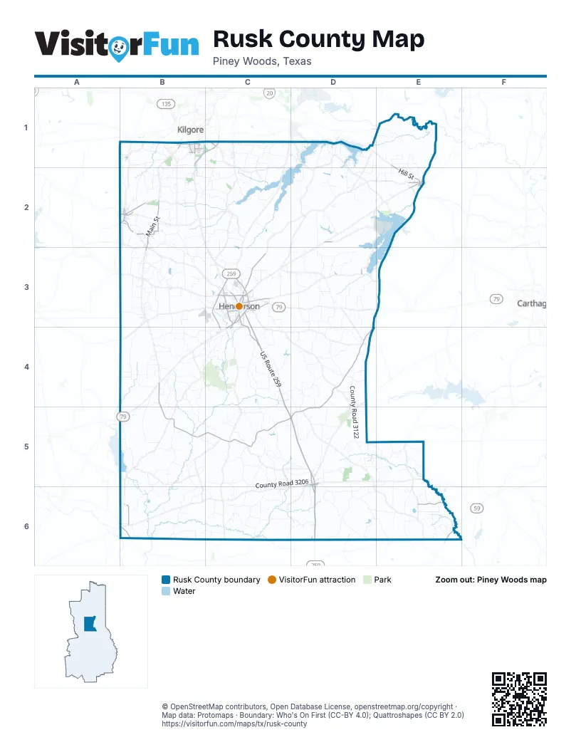
Maps inside Rusk County
1 map inside, from the street map of Rusk County down.
Street index of Rusk County
Each street on the sheet and the grid squares it crosses.
- US Route 259C3, C4, C5, D5, D6
- Landon Alford LoopC3, C4
- South Railroad AvenueD5, D6
- Highway 79C3, C4
- Hill StreetE1, E2, C3
- Charles K Devall Memorial HighwayB1, C1
- SH 64C3
- Kilgore DriveC3
- West Main StreetC3, B6
- McKay StreetB2
- Woodlawn StreetB1
- Johnson StreetB2, E2
- South Commerce StreetB1, B2
- North US Highway 59E6
- South Henderson BoulevardB1
- West Rusk StreetD5
- North Railroad AvenueD5
- Industrial AvenueB1
- North Commerce StreetB2
- East Rusk StreetD5
- US Highway 259D6
- Farm-to-Market Road 1798B4, B5, C5, D5
- Farm to Market 1798 EastD4, D5
- Main StreetB2, B3
- East Main StreetB2, C3
- South Main StreetC3, B6
- North Van Buren StreetC3
- Hwy 323B2
- Jacksonville DriveC3, C4
- Dudley RoadC1
- North Main StreetC3, B6
- West Depot StreetC3
- Millville DriveC3
- Old Nacogdoches RoadC3, C4
- FM 1798 EastD3, E3, D4
- Farm-to-Market Road 2907E6
- Striker RoadB6
- North Marshall StreetC3
- North Evenside StreetC3
- Webster DriveC3
- South Evenside StreetC3
- Sterling Price StreetE2
- East Henderson StreetB2, D5, B6
- North Mill StreetC3
- East Humble RoadB2
- Richardson DriveC3
- Florence StreetB1
- West Humble RoadB2
- Humble RoadB2
- Old Churchill RoadC3
- West Henderson StreetB2, D5
- Southwest 3rd StreetD5, D6
- East Leach StreetB1
- Chandler StreetB1
- Northwest 3rd StreetD5
- County Road 2144D2
- Peterson RoadB1
- North Motley DriveB2
- JeffersonE2
- FM 2658D3
- WhitneyE2
- County Road 3204D5
- East Depot StreetC3
- Hunter StreetB1
- Kennedy AvenueE1
- County Road 3122D4, D5
- County Road 317 SouthC4, D4, D5
- County Road 3191D5, D6, E6
- Cherokee Trail SouthD1
- County Road 3206C5, D5, C6
- County Road 476B4
- County Road 461B4, B5, C5
- County Road 3198D5, E5, D6
- County Road 3267D6, E6
- County Road 3175D5, E5
- County Road 102B2, B3, C3
- County Road 3197D6
- County Road 314C4
- County Road 415B4
- County Road 4255B5
- County Road 355 SouthD4
- County Road 2210E1, E2
- County Road 3155C5, C6
- County Road 173 NorthC1, B2, C2
- County Road 4223B5
- County Road 401 SouthB4, C4
- County Road 462B3, B4
- County Road 4188B4, B5
- County Road 352 EastD4
- County Road 3282E6
- County Road 4105B3
- County Road 368 EastC4, D4
- County Road 3227C6
- County Road 146B2
- County Road 3185D5
- County Road 364 SouthD4
- County Road 3181D5, E5
- County Road 3168C5, D5
- County Road 4232B5, C5, B6
- County Road 414B4, C4
- County Road 4256B5
- County Road 3153D5
- County Road 2127D1, D2
- County Road 3230C6
- County Road 1114B1
- County Road 3163C5
- County Road 4248B5, B6
- County Line RoadC1, E2, E3
- County Road 3196D6
- County Road 272D2
- County Road 366 EastD4
- Lee Creek TrailD1, D2
- County Road 4117B3
- County Road 132 NorthB2
- County Road 3146C5
- County Road 4238B6
- County Road 4182B4, B5
- County Road 3271C6, D6
- County Road 326D3
- County Road 4221B5
- County Road 468B4
- County Road 301C3, C4
- County Road 382C4, C5
- County Road 407B4, C4
- County Road 324D3
- County Road 3281E6
- Cherokee Trail NorthD1
- County Road 336D3
- County Road 3156C5
- County Road 2187E2
- County Road 421NB3, C3
- County Road 3131D4, D5
- County Road 311C4
- County Road 490C4, C5
- County Road 4264B6
- County Road 4245B6
- County Road 118B2, C2
- County Road 445B4
- County Road 402B4, C4
- County Road 3218C6
- County Road 438C4
- County Road 3144D5
- County Road 1115B1
- Compton RoadC4
- County Road 4107B3
- County Road 477B4
- County Road 342 SouthD3, D4
- County Road 394D3
- County Road 3251E5
- County Road 343 EastD3, D4
- County Road 3216C6
- County Road 3284E6
- County Road 3125 SouthD4, D5
- County Road 236 EastB2, C2
- County Road 3238C6
- County Road 3201C5, D5
- County Road 3262D6, E6
- County Road 3257E6
- CR 246C2
- County Road 458B4, B5
- County Road 176C2
- Archie Primm RoadB2
- County Road 222C3
- County Road 3107 SouthD3, D4
- County Road 4156B3
- County Road 4112B3
- County Road 333D3
- County Road 3261E5, E6
- County Road 3143D5
- Harvey RoadB2
- County Road 3189D5, E5
- County Road 3167C5, C6
- County Road 483B3
- County Road 456B4
- Mc Williams RoadB3
- Cassidy LaneC1
- County Road 482C5
- County Road 3268D6
- County Road 437C5
- County Road 4122B3
- Will Mc Clelland RoadB2, B3
- County Road 292EC1
- County Road 426NB3
- County Road 304C3, D3, D4
- Nubbin Fuller RoadB2
- County Road 254C2
- County Road 453B4
- County Road 174B2, C2
- County Road 2132D2
- County Road 262D3
- County Road 475B4
- County Road 4114B3
- County Road 296C1
- County Road 363 SouthD4
- County Road 3157C5
- County Road 3272C6, D6
- County Road 4247B5
- County Road 136 NorthB2
- County Road 4198B5
- County Road 374 SouthD4, D5
- Beaver RunC1, D1, C2
- County Road 3253E6
- County Road 2211E1
- County Road 217C3
- County Road 3285E6
- County Road 138B1, B2
- County Road 2194E1
- Charlie Hunt RoadB2
- County Road 2136D2
- County Road 108B2
- County Road 4135B3
- County Road 4187B4, B5
- County Road 3195D5
- County Road 452B4, C4
- County Road 186B1, C1, C2
- County Road 3127ED4, D5
- County Road 378C4
- Scarbrough RoadC3
- County Road 2185D1, D2
- County Road 2125D1
- County Road 2133DD2
- Flanagan RoadE1, E2
- County Road 471B4
- Dill RoadB2
- County Road 4178B5, C5
- County Road 3145D5
- County Road 328D3
- County Road 2214E1, E2
- Elm StreetB2, C3
- County Road 4136B3
- Florey Ranch RoadB1, B2
- County Road 4154B3
- County Road 376C4
- County Road 3250E5
- County Road 4230B5
- County Road 436C5
- County Road 4145B3
- County Road 3266D6, E6
- County Road 157B1, B2
- County Road 3121D4
- County Road 3103D3
- County Road 3207D6
- County Road 327D3
- County Road 303C3, C4
- County Road 478B3, B4
- Crystal Farms RoadE2
- Major Kennedy RoadB1
- County Road 347D3
- Don Leverett RoadB2
- CR 240C2
- County Road 3233C6
- County Road 3226C5, C6
- County Road 424 WestB3, C3
- County Road 442DB4, C4
- County Road 481B3
- County Road 308C4
- Walker King RoadB3
- County Road 283C2
- County Road 286DC2
- County Road 103B2, B3
- County Road 361 SouthD4
- County Road 3166C5
- County Road 382AC4
- County Road 459B4
- County Road 3280E6
- County Road 4174C5
- Steward RoadC1, C2
- County Road 3102D3
- Preacher Lee RoadB2
- Dean RoadB2, C2, C3
- County Road 4236DC6
- County Road 3228C6
- County Road 455B4
- County Road 4137B3
- County Road 3223C5, C6
- County Road 3286E6
- Danny Roman RoadC2
- County Road 4186B4
- Florey Lake RoadB1
- County Road 4170C5
- County Road 4172DC5
- County Road 353 SouthD4
- County Road 266D3
- County Road 485C4, C5
- County Road 182B2, C2
- County Road 3165C5
- County Road 365 EastD4
- County Road 3159C5
- County Road 4111B3
- County Road 2143D2
- County Road 351 SouthD3, D4
- County Road 171B1
- County Road 4233B6
- County Road 3147C5, D5
- County Road 313 SouthC3, C4
- County 3227C6
- County Road 443DC4
- Allen RoadE1, E2, C3
- County Road 4148B3
- County Road 454B4
Places on the map
- A.W. Phillips Athletic Complex
- Allen Lake
- Ashby Lake
- Beaver Marsh
- Browns Lake
- Buckner Lake
- County Lake
- East Texas Multi-Use Facility
- Fair Park
- Florey Lake
- Graham Lake
- Grassy Lake
- Henderson
- Henderson High School
- Hendricks Lakes
- Indian Pond
- James Bradshaw State Jail
- Jones Lake
- Lake Cherokee
- Lake Forest
- Lake Forest Park
- Lake Manr
- Lake Roman
- Langford Lake
- Long Glade Lake
- Martin Creek Lake
- Martin Creek Lake State Park
- Miller Lake
- Mount Enterprise
- New London
- Nix Lake
- Overton
- Rusk County Airport
- Shaw Lake
- Soil Conservation Service Site 3 Reservoir
- Soil Conservation Service Site 5 Reservoir
- Southwest Industrial Park
- Tatum
- West Rusk Schools
- Willow Lake
Next to Rusk County
- Carthage
- Kilgore map
© OpenStreetMap contributors, Open Database License, openstreetmap.org/copyright · Map data: Protomaps · Boundary: Who's On First (CC-BY 4.0); Quattroshapes (CC BY 2.0)















