

Texas map
Jacksonville map
About 14,639 people live here (Census Bureau, 2024 estimate). The sheet's index lists 300 streets; US Highway 69 North, Southeast Loop 456 and North Bolton Street cross the most grid squares. Also on it: Nichols' Green Park, Baseball and Soccer Complex and Fred Douglas Elementary.
Open the map (PDF, US Letter)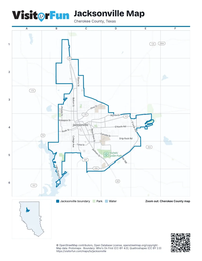
Street index of Jacksonville
Each street on the sheet and the grid squares it crosses.
- South Jackson StreetC4, C5, D5
- East Rusk StreetC4, D4, E4
- North Jackson StreetC2, C3, C4
- US Highway 69 NorthB1, B2, C2, D5
- East Pine StreetC3, D3, C4
- West Rusk StreetB4, C4
- US Highway 79 EastE4
- Frankston HighwayB3, C3
- West Larissa StreetB4, C4
- US Highway 175 WestB3
- Alexander BoulevardC3
- Southeast Loop 456E4, C5, D5, E5
- North Bolton StreetB2, C2, C3, C4
- South Bolton StreetC4, C5
- East Loop 456E4
- East Cherokee StreetC4
- Myrtle DriveC4, D4
- O'Keefe RoadD4, E4
- Canada StreetC4, D4
- Corinth RoadC5, D5
- Beaumont StreetC4, C5
- Austin StreetC4, C5
- Fort Worth StreetC4, D4
- Tena StreetC5
- Dogwood StreetE4
- Kickapoo StreetB4, C4
- North Pineda StreetB3, B4
- Gillespie AvenueB4
- Phillip AvenueD4
- Brookside DriveC4
- County Road 4118B2
- Adams StreetC5
- Fulton StreetC4
- FM 347 NorthC5, C6
- North Quevado StreetC3
- FM 768D5
- FM 2138 NorthC5
- Lake Shore DriveB5, B6
- Drip Rock RoadD4, E4, E5
- Quevado StreetB3, C3
- South Bonner StreetC4, C5
- College AvenueC4, C5
- Elberta StreetC2, C3
- Burma RoadC3, C4
- Devereux StreetB4, C4
- Martin Luther King Jr BoulevardC3, C4
- South Pineda StreetB4, B5
- Avalon StreetC4, C5
- North Ragsdale StreetC3, C4
- Burleson StreetB4, C4
- Pebble Beach DriveE4
- Pierce LaneC4
- Tyler StreetC4
- East Wilson StreetC4
- Jefferson AvenueB3, B4
- Palestine StreetC4
- West Pine StreetB4, C4
- Alameda DriveC4, D4
- Debusk StreetC3
- Sunset AvenueB4, C4
- Churchill StreetC3
- Johnson StreetB3, B4
- Henderson StreetC4
- Hillcrest StreetC4, D4
- Byrd RoadC5, B6
- South Main StreetC4
- North Main StreetC3, C4
- Talley Nichols DriveC5
- Woodlawn AvenueB4, C4
- El Paso StreetC4
- John StreetC4
- Nacogdoches StreetC4
- Deaton StreetC4
- Lawrence StreetB4, C4
- East Lincoln StreetC4
- Alabama AvenueB4, C4
- Washington AvenueB4
- Bryan StreetC4
- South Ragsdale StreetC4
- Sims AvenueC3
- Toby LaneD4
- San Antonio StreetC4
- Waco StreetC4
- North Patton StreetB4, C4
- Davis StreetC3
- Neches StreetC4
- Bailey LaneD4
- Glen Fawn RoadE4
- Brady StreetC3, C4
- Brown StreetC4, C5
- Mc Knight StreetC5
- Oak StreetC4
- Monroe StreetB4
- Marshall StreetC4, C5
- Benson StreetC3
- Hickory StreetB4
- James StreetC4
- Woodhaven StreetB5, C5
- Indian TrailB1
- Grant AvenueC3, C4
- Looney StreetC3
- Harvard DriveD4
- Martin Luther KingC3
- Travis StreetB4
- Dallas StreetC4
- Mc Arthur DriveC3, D3
- Holloway AvenueC3
- Beach StreetE4
- Border StreetC3
- Valley View LaneC5
- East Commerce StreetC4
- Broiles StreetC5
- Mason DriveC4
- Beacon DriveC3, C4
- Madison StreetB4
- Crockett StreetC3, C4
- Willow Creek DriveC4, D4
- South Patton StreetC4
- Edgewood DriveC4
- Pineda StreetB5
- Pecan StreetB4
- Jowell StreetB2, C2
- Meadowhill DriveD4
- Dorothy StreetB3, C3
- Harrison StreetB4
- Purdue StreetD4
- Garner LaneD4
- Cherry StreetC4
- Augusta DriveE4
- Andrews StreetC5
- Skyline BoulevardC3
- Tremont StreetC5
- Georgia AvenueB4, C4
- Park DriveC3
- Jeff Davis StreetC3
- Carolina StreetC4
- Goodwin StreetB3
- Howard StreetC5
- Newburn StreetC4
- Water StreetB4
- Kelly StreetC5
- Japonica LaneB2, C2
- Love AvenueB4
- West Lincoln StreetB4, C4
- Tilley StreetC4
- Redbird LaneC3
- Dublin DriveB3
- Greely AvenueC3, C4
- Sheridan StreetC3, C4
- Sycamore StreetB4
- Ridgecrest DriveC5
- Kirkwood LaneD4
- Forest TrailD4
- Jacksonville DriveC5, D5
- Heath LaneC2
- Prestwick RoadE4
- MorrisD4
- Cedar StreetB4
- Idle Creek RoadB5
- Bonita StreetC5
- Earl StreetC5
- Fuller StreetC5
- Alexander StreetC5
- Nance StreetD4
- Williams DriveB3
- Gaston StreetC3
- Timberline DriveD4
- Crestview LaneD5
- Wilkens AvenueC3
- Aqua VistaB6
- Preston TrailE4
- Asbury StreetD4
- Cash StreetD4
- Angelina StreetD4
- Coleman AvenueC3
- Lenora StreetD4
- San Jacinto StreetB4
- Robinson LaneB4
- Lake StreetC4
- Prather StreetC4
- Selman StreetB3
- West Commerce StreetC4
- Griffin StreetB3, C3
- Cherokee TrailC4
- Bainbridge StreetC4
- Briarwood DriveE4
- Lawler StreetC4
- Sunnydale StreetC5
- Park LaneC5
- Hazel StreetB4
- Pinecove StreetE4
- Farnsworth StreetC4
- Pepples StreetB4
- Esther StreetC3
- Ivey AvenueC5
- East Larissa StreetC4
- Hall AvenueC5
- Gay AvenueC5
- LakeshoreB6
- East Lawrence StreetC4
- Lake Park LaneB6
- Elm StreetC4
- Alto StreetC4
- East Woodrow StreetC4
- BriarcoveD4
- Bruno LaneB3, C3
- Bass Hollow CircleB5
- Brook Hollow DriveC4, D4
- Dial StreetD4
- ThompsonC4
- Birdwell LaneB5
- Highland AvenueC4
- Baylor StreetD4
- Moore StreetC3
- South StreetC4
- Bridge StreetB4
- Glenda Dement BoulevardD5
- Anvil StreetC2
- North Bonner StreetC4
- Beall BoulevardC3
- Jeanine StreetC3
- NorthgateC2
- Champion StreetE4
- Ellis StreetC3
- Sam Bowles RoadD4
- Forrest StreetC3
- Circle DriveC4
- Norman DriveC5
- County Road 3158C5
- Crestwood DriveC4, D4
- Heritage DriveC5, D5
- King DriveE4
- Florence StreetC3
- Berry LaneD4
- Neal StreetC5
- Stanford StreetD4
- Holly StreetE4
- Liveoak StreetE4
- Reagan StreetB4, C4
- Mary Jane StreetD5
- Meadowbrook DriveD4
- MonkressB5
- BellaireE4
- Tucker LaneB3, C3
- Arnold StreetC3
- Center StreetB4
- San Marcos StreetC4
- Murray StreetB5
- San Saba StreetC4
- Otts StreetB3
- Milton StreetB3
- Wesley StreetC4
- Medi Vac RoadC5
- Plantation StreetD4
- Texas AvenueB4
- Mary StreetC4
- Memorial DriveB2, C2
- Columbia AvenueC3
- Helen StreetC3
- Mulberry StreetB4
- Ridge Park BoulevardC5, D5
- Bethune StreetB3
- Rosalee StreetC3
- ElmwoodE4
- Akers StreetC5
- County Road 4203D4
- B J Albritton DriveB4
- Dump Station RoadB6
- Wynn DriveC4
- BucknerC4
- Adair StreetC2
- Progress StreetC2
- Sherwood LaneD4
- Mills StreetB5
- Sherman StreetC3
- Newton StreetC4
- Woodside StreetC2
- Timberhill RoadE5
- South Ridge DriveC5
- Keith StreetC4, C5
- Magness LaneD3, D4
- County Road 4101C3
- Lloyd StreetC4
- Kings DriveE4
- King RoadE4
- Dustin StreetB3
- Marvin StreetC3
- Button Bush LaneC5
- Oak DriveE4
- Landress StreetC3, C4
- Willow StreetB4
- Houston StreetC4
- Cordelia StreetC4
- Cottonwood StreetB4
- Edward StreetB4
- Greenbriar RoadE4
- Ardis StreetC4
- BarnesB5
- Clemons DriveC3
- Moak LaneE4
Places on the map
- 7-Eleven
- ABC Auto Parts
- Baseball and Soccer Complex
- Best Western Jacksonville Inn
- Brookshire Brothers
- Buckner Park
- Cherokee County Sheriff's Office Ops Center
- Chick-fil-A
- Chili's
- Commerce Street Drafthouse
- Conoco
- Dollar General
- DQ Grill & Chill
- East Side Elementary School
- Executive Inn
- Family Dollar
- Fred Douglas Elementary
- Gossett's Chapel Cemetery
- Holiday Inn Express
- Jackson Cinema 3
- Jacksonville City Hall
- Jacksonville College
- Jacksonville High School
- Jacksonville Middle School
- Jacksonville Post Office
- Jacksonville Public Library
- Joe Wright Elementary School
- KFC
- La Quinta Inn & Suites Jacksonville TX
- Lake Jacksonville Park
- Lincoln Park
- McDonald's
- Murphy USA
- Nichols Intermediate School
- Nichols' Green Park
- O'Reilly Auto Parts
- Resthaven Cemetery
- Shell
- UT Health - Jacksonville
- Walmart Supercenter
© OpenStreetMap contributors, Open Database License, openstreetmap.org/copyright · Map data: Protomaps · Boundary: Who's On First (CC-BY 4.0); Quattroshapes (CC BY 2.0)















