

Texas map
Cherokee County map
About 53,223 people live here (Census Bureau, 2024 estimate). The sheet's index lists 300 streets; US Highway 69 South, County Road 4606 and US Highway 69 North cross the most grid squares. Things to do inside the boundary: Caddo Mounds State Historic Site.
Open the map (PDF, US Letter)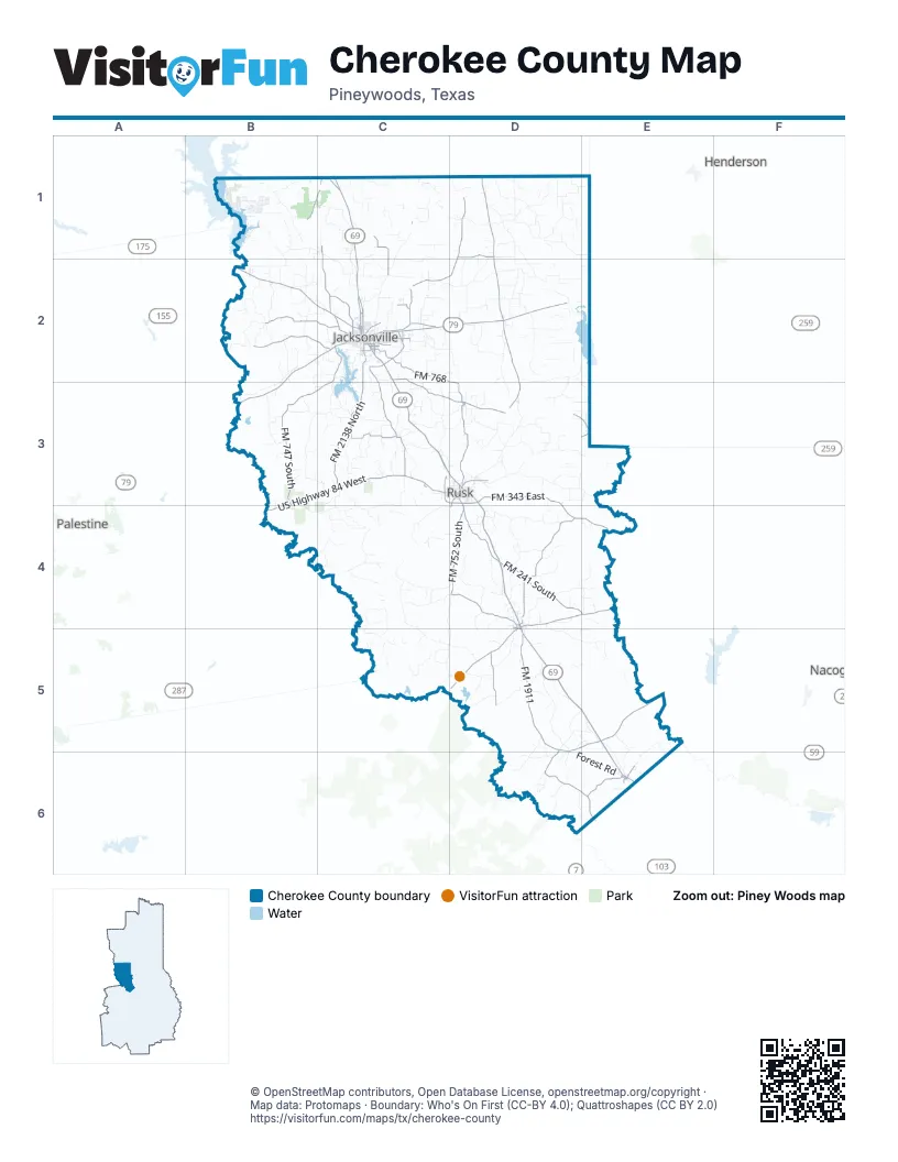
Maps inside Cherokee County
1 map inside, from the street map of Cherokee County down.
Street index of Cherokee County
Each street on the sheet and the grid squares it crosses.
- US Highway 69 SouthD3, D4, D5, E5, E6
- US Highway 69 NorthC1, C2, C3
- US Highway 79 EastC2, D2
- US Highway 84 WestB3, C3, B4
- US Highway 175 WestB2, C2
- US Highway 79 WestB2, C2, B3
- West State Highway 21D5
- East State Highway 21D4, E4
- South Jackson StreetC2
- East Rusk StreetC2
- West 6th StreetC3, D3, E6
- North Jackson StreetC2
- Rusk StreetD3, D4, E6
- East Johnson DriveD3
- South Dickinson DriveD3
- East Pine StreetC2
- North Dickinson DriveC3, D3
- East 6th StreetD3, E6
- West San Antonio StreetD4, D5
- East San Antonio StreetD4
- West Rusk StreetC2
- South Marcus StreetD4, D5
- West Main StreetE3
- Frankston HighwayC2
- North Marcus StreetD4
- North Henderson StreetD3
- West Larissa StreetC2
- Elkhart StreetD4, D5
- Alexander BoulevardC2
- US Highway 175B2
- State Highway 110 NorthD1, D2, D3
- FM 747 SouthC2, B3, C3
- Farm-to-Market Road 2064D1, C2, D2
- Loop 343C3, D3
- Southeast Loop 456C2
- North Bolton StreetC2
- North Main StreetC2, D3, E3
- Farm-to-Market Road 2750D1
- South Bolton StreetC2
- South Houston StreetC1
- East Loop 456C2
- Crockett StreetC2, D3, D4
- East Cherokee StreetC2
- South Georgia StreetD1
- FM 1911D5, E5, D6
- FM 768C2, D2, D3
- FM 241 SouthD4, E4
- FM 752 SouthD4
- FM 343 EastD3, D4, E4
- FM 2138 NorthC2, C3
- FM 851 SouthD4
- FM 347 NorthC2, C3
- Farm-to-Market Road 22C2, C3, D3
- FM 1247 WestD5, D6, E6
- County Road 3305B2, C2
- FM 747 NorthB2, C2
- County Road 3405C1, C2
- Farm-to-Market Road 1910C3
- Farm-to-Market Road 220D5
- North Enterprise RoadC1, C2
- County Road 4211C2
- County Road 4118C2
- County Road 3707B1, C1
- Myrtle DriveC2
- O'Keefe RoadC2
- Canada StreetC2
- South Main StreetC2, D3, D4
- Corinth RoadC2
- FM 1819 SouthE6
- County Road 4209C2
- Beaumont StreetC2
- Austin StreetC2, D3
- East 4th StreetD3, E6
- Myrte DriveC2
- Kickapoo StreetC2
- North Pineda StreetC2
- Chapman RoadE6
- Fort Worth StreetC2
- County Road 3301C2
- Tena StreetC2
- Palestine StreetC2, D4
- Dogwood StreetC2
- West 4th StreetD3, E6
- Gillespie AvenueC2
- Homer AvenueE6
- Phillip AvenueC2
- Brookside DriveC2
- Schoolhouse RoadC1
- Church AvenueD4
- South Barron StreetD3
- Park Road 76C3
- South Chandler StreetD3
- Quincy AvenueD4, D5
- West 1st StreetD3
- Toll Smith RoadC2
- County Road 4212C2
- Adams StreetC2
- Fulton StreetC2
- North Quevado StreetC2
- Main StreetD3, D5
- County Road 3919C1
- Mixon RoadC1
- County Road 2501D4, E4
- County Road 2707D5, D6
- Moon City RoadD3
- County Road 3311B2
- County Road 2217C4
- Hunting ClubC4, C5
- County Road 2604D4, D5, E5
- Pine Grove RoadB3, C3
- County Road 4303D2, D3
- Cherokee Hunting ClubB4, C4
- County Road 4727D2
- County Road 3414C1, B2, C2
- County Road 1405C2, D2
- County Road 4701D1, D2
- County Road 2107C3, C4
- County Road 3212B2, B3
- County Road 1301D3
- Antioch RoadC2, C3
- County Road 4223C2, D2
- County Road 3601B1
- County Road 1316D3
- Iron Bridge Creek RoadB3, B4, C4
- County Road 1309D3
- County Road 4716C1, D2
- County Road 3908C2
- Forest RoadD6, E6
- County Road 2907C5, D5
- County Road 4608D1, E1
- Hardy White RoadD4
- County Road 2920C5
- County Road 4705D1
- County Road 2404D4
- County Road 1503C3, D3
- County Road 4301D2
- County Road 3411B1, C1, B2
- Bull Creek Hunting ClubC4, C5
- County Line RoadC1, D1
- County Road 4715D1, D2
- County Road 4706D1
- County Road 1804B3, C3
- Batton LoopB3
- County Road 1707C3
- County Road 2323C4, D4
- Rider RoadC4, D4
- County Road 2813D5, D6
- County Road 2628D4, E5, E6
- County Road 2631E5, E6
- CR 4222D2
- County Road 2313C4, C5
- County Road 4501D2
- County Road 4504D2
- County Road 3701C1
- County Road 4101C2
- Beard Mountain RoadC3
- County Road 2325C4, D4, D5
- County Road 2509D4
- County Road 2723D5, E5
- County Road 3310B2
- County Road 3703C1
- C R 1701C3
- County Road 4807D1
- County Road 3402C1, C2
- County Road 4216C2
- County Road 3214B2
- County Road 2829D6
- County Road 3323B2
- County Road 2619D5, E5
- County Road 4411D2, D3, E3
- Neches River RoadB2
- County Road 4709D1
- County Road 2214C4
- County Road 2806D5
- County Road 1310D3
- County Road 4401D2, D3
- County Road 2801D5
- County Road 3306B2
- County Road 3401C1, C2
- County Road 3108C3
- County Road 4405D2
- County Road 2905D5
- County Road 2310C4, D4
- County Road 1106D4
- County Road 3216B2, C2
- County Road 4621D1, E1
- County Road 2213C4
- County Road 2717D5
- County Road 1613C3
- County Road 2218C4
- County Road 2752D6
- C R 2407D4
- Coon Pond Hunting ClubC5
- County Road 1506C3
- County Road 2436D4
- County Road 4910C1
- County Road 4619D1
- Drip Rock RoadC2
- County Road 4703D1
- County Road 1508C3
- County Road 3210B2, B3
- County Road 3406B1, C1, B2
- Piney Point DriveC2, C3
- County Road 2114C3, C4
- County Road 1409C2
- Old Taylor Hill RoadC3
- County Road 2517D4, E4
- County Road 4612D1
- County Road 1605C3
- County Road 4905C1, D1
- County Road 4913D1
- Jarrat StreetC3, C4
- County Road 3312B2
- County Road 2831D6, E6
- County Road 4722D2
- County Road 3211B2, B3
- County Road 3220B2, B3
- County Road 2512D4
- County Road 4620D1
- County Road 1101D4
- Bagley RoadD3
- Byrd RoadC2
- Lake Shore DriveC2
- County Road 4224D1, D2
- County Road 2807D5
- County Road 4623D1
- County Road 4228D1, D2
- County Road 2221C4
- County Road 3605B1
- County Road 1713C3
- County Road 2206C4
- County Road 3704B1, C1
- County Road 4704D1
- County Road 3602B1
- County Road 2728E5
- Farm-to-Market Road 147B2
- County Road 2626E5, E6
- County Road 3104C2, C3
- County Road 4625D1
- Perry Hunt ClubD5
- County Road 2812D5
- Pear Ridge RoadC1
- County Road 4610D1
- County Road 3303C2
- County Road 3910C1, C2
- County Road 1305D3
- County Road 4903C1, C2
- County Road 3504B1
- San SabaB1
- County Road 1408C2
- County Road 2803D5
- County Road 4606D1, E1, D2, E2
- Piney Grove RoadC3, D3
- County Road 2506D4
- County Road 1616C2, C3
- County Road 3506B1
- County Road 2326D4, D5
- East Twin Creeks TrailC1
- County Road 1513C3
- County Road 2816D6
- County Road 1615C2, C3
- County Road 4605D2
- County Road 1215D3, E3
- Summit DriveC2, C3
- County Road 4414D2
- County Road 1212D3, C4
- County Road 1210D3
- County Road 1603C3
- County Road 1306D3
- County Road 1207D3
- County Road 2610D4
- County Road 2825D6
- County Road 2409D4
- Old Mixon RoadC1, C2
- County Road 2103C3
- County Road 3906C1
- County Road 2715D5
- County Road 3905C1, C2
- County Road 1414C2
- CarolineB1
- County Road 1410C2
- Eagle's Bluff BoulevardB1
- Edwards Farm RoadC1
- County Road 1315D3
- County Road 1211D3, E3
- County Road 4712D1
- County Road 4720D2
- Farm-to-Market Road 1711C3
- County Road 1515C3
- County Road 3203B2, C2
- County Road 4218C2
- County Road 4408D3, E3
- Lake Springs RoadC2
- Holley Springs RoadC3
- County Road 1504C3
- Church Hill RoadB2, C2
- Sheffield RoadC3
- County Road 1418D3
- County Road 1102D4
- County Road 1214D3
Things to do on the Cherokee County map
Places on the map
- Alto
- Baseball and Soccer Complex
- Brock Lake
- Brushy Lake
- Bullard High School
- Buzzard Slough
- Cherokee County Airport
- Cherokee Lake
- City Lake
- Coon Pond
- Crysup Lake
- Cuney
- Dead Water Lake
- Duren Lake
- Eagles Bluff Country Club
- Fred Douglas Elementary
- Gallatin
- Grassy Pond
- Greenhead Lake
- Holloway Lake
- Hollywood Lake
- I.D. Fairchild State Forest
- Jacksonville
- Jacksonville Club Lake
- Jacksonville High School
- Jerry H. Hodge Unit
- Lake Acker
- Lake Jacksonville
- Lake Striker
- New Summerfield
- New Summerfield School
- Nichols' Green Park
- Pine Crest Lake
- Reklaw
- Rusk
- Rusk Independent School District
- Rusk State Hospital
- State Hospital Reservoir
- The Challenge at the Woods
- Wells
Next to Cherokee County
© OpenStreetMap contributors, Open Database License, openstreetmap.org/copyright · Map data: Protomaps · Boundary: Who's On First (CC-BY 4.0); Quattroshapes (CC BY 2.0)















