

Texas map
Kilgore map
About 13,583 people live here (Census Bureau, 2024 estimate). The sheet's index lists 300 streets; State Highway 135 North, US Highway 259 Business North and State Highway 42 cross the most grid squares. Also on it: Downtown Kilgore, Southwest Industrial Park and Synergy Business Park.
Open the map (PDF, US Letter)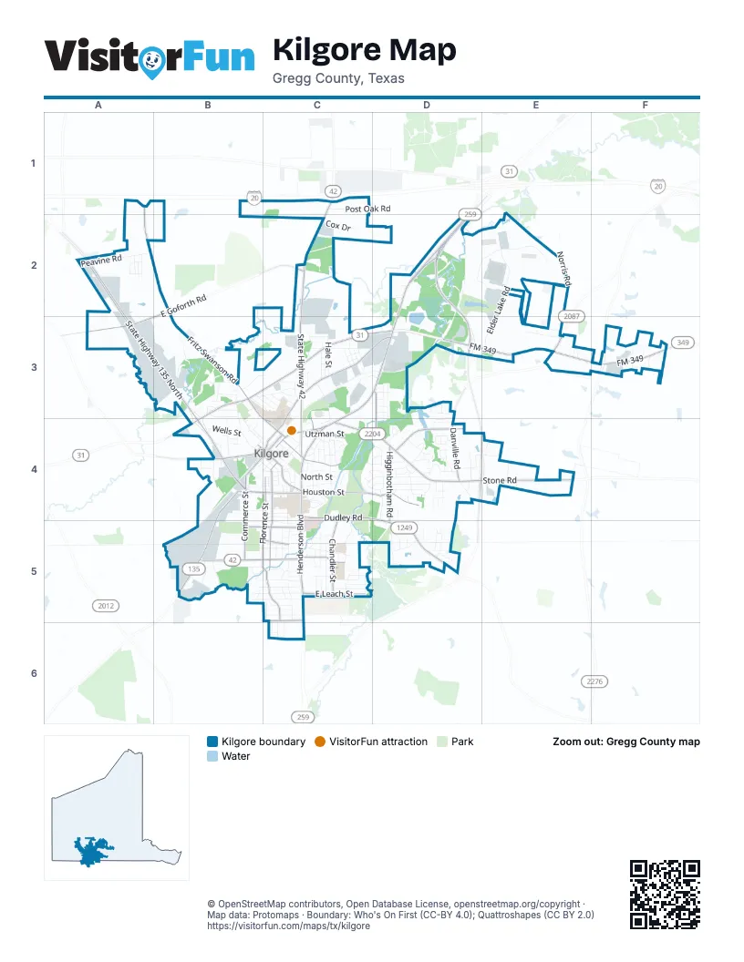
Street index of Kilgore
Each street on the sheet and the grid squares it crosses.
- State Highway 135 NorthA2, A3, B3, B4
- US Highway 259 Business NorthD2, C3, D3, C4
- State Highway 42C1, C2, C3, C4
- Charles K Devall Memorial HighwayD2, D3, D4, E4
- Houston StreetB4, C4, D4
- State Highway 31 EastB3, C3, D3
- Woodlawn StreetB5, C5
- South Henderson BoulevardC4, C5
- Industrial AvenueB4, B5
- US Highway 259 NorthD2
- State Highway 31 WestB3
- East Lantrip StreetC4
- North Henderson BoulevardC4
- Stone RoadC4, D4, E4
- FM 349D3, E3, F3
- Dudley RoadC4, D5
- South Commerce StreetB4, C4, B5
- East Goforth RoadC2, A3, B3
- North Kilgore StreetC4
- East Main StreetC4
- North Commerce StreetC4
- Old Kilgore HighwayE3
- Campbell StreetC3, C4
- Fritz Swanson RoadA2, B2, B3, C4
- North Longview StreetC3, D3, C4
- Florence StreetC4, B5, C5
- South Martin StreetC4, C5
- Chandler StreetC4, C5
- Higginbotham RoadD4, D5
- Danville DriveD4
- Danville RoadD4
- East Leach StreetC5
- East Harris AvenueB5, C5
- Gladewater StreetB4
- Pentecost RoadD3, D4
- Peterson RoadC5
- Old Highway 135B4
- Hunter StreetB5, C5
- West Lantrip StreetC4
- West Main StreetB4, C4
- Broadway BoulevardC4, C5
- Alliance WayD2, E2
- Elder Lake RoadE2, E3
- Martin Luther King StreetB3, B4
- Norris RoadE2, E3
- Green Hills DriveC4, D4
- Peavine RoadA2
- Spinks Chapman RoadE1, E2
- Willow Spring RoadC4, D4
- Van Meter RoadB3
- Parkview StreetC4
- County RoadC3, D3
- Post Oak RoadC1
- East South StreetC4
- Energy DriveC3, D3
- Synergy BoulevardD2, E2, D3
- Laird AvenueB4, C4
- Redbud StreetC5
- Maverick DriveC2, C3
- Highland DriveB5, C5
- Camp StreetB5, C5
- Rockbrook DriveD4
- Leach StreetB5, C5
- Florey StreetB5, C5
- East North StreetC4
- Bean AvenueB5, C5
- Utzman StreetC4
- Kathleen StreetC5
- Horseshoe DriveC4
- Southport RoadC3, C4
- Brook DriveC4
- Emmons StreetB5, C5
- Wells StreetB4
- White StreetD5
- Thompson StreetC4
- East Kay StreetC4
- Swanson RoadB3
- County Line RoadD5
- Royal DriveD4
- Templeton RoadF3
- Whippoorwill LaneC4, C5
- South Danville RoadD4
- Hale StreetC3
- Amanda LaneC5
- Airport RoadE3
- Rim RoadD4
- West North StreetB3, B4, C4
- Williams StreetC3
- Knowles StreetB4, C4
- Beckley StreetC5
- Sceyne RoadC4
- Luder StreetC3
- Riverside DriveC4
- Crim AvenueC4
- Windsor Park LaneE3
- Memorial StreetB4, B5
- South Rusk StreetB4, C4
- Clay StreetC5
- Myrtle StreetC4
- Birch LaneC5
- Miles BoulevardD3, D4
- Tuff StreetB3, C3
- Looney AvenueC4
- Cox DriveC2
- Wildwood LaneC4, D4
- Peach StreetC5
- Simmons StreetC5
- Larkspur LaneC5, C6
- Andrews StreetC4
- Crescent DriveD4, D5
- Stone StreetC4
- Town Oaks CircleD4
- Edgewood RoadD4
- North StreetC4
- Reynolds StreetC3
- Newtown RoadB3
- Crestwood LaneD4
- Bailey StreetC3
- Montgomery StreetB3, C3
- Tucker RoadC3
- Monroe StreetB5, C5
- Carroll AvenueD5
- Richards StreetC4
- Michael StreetD4
- Pine Burr LaneD4
- Sanders StreetB3
- Nolen AvenueC4
- Oak DriveC4
- Whiteside LaneB5
- Bagwell StreetB4, C4
- County Road 1124B5
- Barnett StreetB4, C4
- Forest LaneD4
- Walnut StreetD3
- Woodview LaneD3
- Woodway StreetD4
- Turner StreetC5
- Layton StreetC5
- School StreetC3, C4
- Cedar LaneA2, D3
- Sycamore DriveA2
- Kings HighwayB3, C3
- Ash LaneC4
- Bates StreetB4
- Roy StreetC5
- Woodbine DriveB5
- Gulf Camp RoadB5
- Lockhaven DriveD4
- Sunset LaneB5
- Gulf Hercules RoadB4
- Wilshire RoadD4, E4
- Turkey Creek DriveB5, C5
- FFA RoadE4
- Paluxy DriveB5
- Bell StreetB3, C3
- Idylwood DriveD5
- Carlisle DriveC4
- Mimosa StreetD4
- Dwain DriveC5
- Forest Hills DriveD4
- Elder StreetC4
- Littleton RoadD4
- Mustang DriveE3
- Roberts StreetD5
- Hillcrest RoadC2
- Ross AvenueC4
- North Martin StreetC4
- Wychelm DriveC4, D4
- Barton StreetC4
- Greene StreetC3
- East Couch AvenueC5
- Spell StreetC3
- Emily StreetC5
- East Sabine StreetC4
- Alexander StreetB3
- Enterprise StreetE2
- Still StreetC3
- Everett StreetC5
- Lakewood StreetD3, D4
- Harvey BoulevardC3
- Beall StreetC3
- Thomas StreetC3
- Tierra Del Sol StreetB3
- Cypress DriveA2
- Meadow AvenueC4
- Duncan StreetC5, C6
- Meadowgreen DriveD5
- Pinecrest DriveC5, C6
- Crestview LaneD5
- Boettcher DriveC5
- Cherokee TrailD4
- Ivy StreetC5
- Aspen StreetC5
- Spruce StreetC5
- Mockingbird LaneC4
- Burch StreetA2
- Choice StreetC4
- Eastridge RoadD4
- Eden DriveD4, D5
- South StreetC5
- Helen StreetC4
- Watson RoadB5
- Inwood CircleD4
- Ledbetter DriveD4
- 4th AvenueB3, B4
- Inwood RoadD4
- Lawrence StreetC4
- Spear StreetB4, C4
- Birdsong StreetD4
- Dudley DriveD4, D5
- Dudley LaneD5
- Garland RoadD5
- Tidewater StreetC3
- PR 3531A2
- Penney LaneC5
- Swanson StreetB3
- Horton StreetD4
- Roger StreetB4
- Sequoia CircleD4
- Kilgore PlazaC4
- Hanover StreetA3, B3
- Driftwood StreetA2
- Willow Bend StreetD4
- Angeline StreetD3
- Moccasin TrailC4, D4
- East Danville StreetB4, C4
- Miller StreetC3
- Lauralee LaneD5
- Hardy RoadA2
- Smackover RoadB4
- Pine StreetC4
- Mark Daniels RoadE4
- Town Oaks DriveD4
- Midtown PlazaC4
- Private Road 2507E4
- Darwin StreetD4
- Emerson StreetB4
- Neal StreetC3, D3
- Browne StreetF3
- Remington CourtC5
- Perry StreetC3
- Mc Entyre StreetC5
- Sabine StreetB4
- Oliphant RoadB4
- Pearl StreetD4
- Longview StreetB4, C4
- Couch AvenueC5
- Fredonia RoadF3
- Griffin StreetB4
- Burns StreetB4
- Crestview PlaceD5
- Timberdale DriveD4
- Cedar StreetD4
- Rogge DriveC3
- William StreetB3
- Juniper StreetA2
- Merrit BoulevardA3, B3
- Crimwood LaneC5
- Oehler StreetB4
- Plum StreetD3
- Hickory StreetD3
- Regent StreetD4
- Sweet Gum LaneC5
- Karolina StreetC5
- Lacy StreetB4
- Caldwell StreetC3
- James StreetB4
- Stoneridge RoadD4
- Powell StreetB4
- Shasta WayC5
- 1st StreetD4
- 3rd AvenueB4
- Fason DriveC3
- Wood StreetC4
- Douglas StreetB4
- Line StreetB3
- Park LaneC4
- Utzman RoadE3
- Hart StreetC5
- Mexia StreetB4
- County Road 2387D3
- Spring Tree LaneD3
- Mc Michael StreetC6
- Stonehaven CourtD4
- Dogwood TrailC4
- Corrigan StreetC4
- Lewis StreetB4
- Phillips StreetC3
- Sherry StreetD4
- Giles StreetC3
- Maple StreetC4
- Ridgecrest LaneD4
- Oakwood LaneD3
- Dickson CourtB4
- Mike StreetD5
- Briar LaneD4
- Hillvale StreetD4
- Rogers StreetB4
- County Road 2386C3
- Gateway DriveD4
Places on the map
- & Hooks P. S.
- 4 Star Cinema
- Aaron's
- ABC Auto
- All Star Ford
- Allegiance Specialty Hospital
- Ann Dean Turk Fine Arts Center & Van Cliburn Auditorium
- Atwoods
- Austin Bank
- AutoZone
- Ballpark at KC Commons
- Blake Furniture
- Brookshire Gas station
- Camfil
- Chandler School
- Downtown Kilgore
- Duncan Lake
- Elder Lake
- Elder Lake at Synergy Park
- Harris Street Park
- Kilgore Cemetery
- Kilgore City Park
- Kilgore College
- Kilgore High School
- Kilgore Intermediate School
- Kilgore Plaza
- kilgore sports complex
- Martin Luther King Junior Park
- Martin Transport
- Meadowbrook Dog Park
- Meadowbrook Golf & Event Center
- Meadowbrook Park
- Midtown Plaza
- Old Kilgore Baseball Fields
- Pinecrest Baptist Church
- Sabine Pipe & Supply
- Southwest Industrial Park
- Synergy Business Park
- TA Express
- Whataburger Sports Complex
© OpenStreetMap contributors, Open Database License, openstreetmap.org/copyright · Map data: Protomaps · Boundary: Who's On First (CC-BY 4.0); Quattroshapes (CC BY 2.0)















