

Texas map
Gregg County map
About 126,679 people live here (Census Bureau, 2024 estimate). The sheet's index lists 300 streets; West Loop 281, Walnut Street and Gilmer Road cross the most grid squares. Things to do inside the boundary: Kilgore, Longview and Longview Museum of Fine Arts.
Open the map (PDF, US Letter)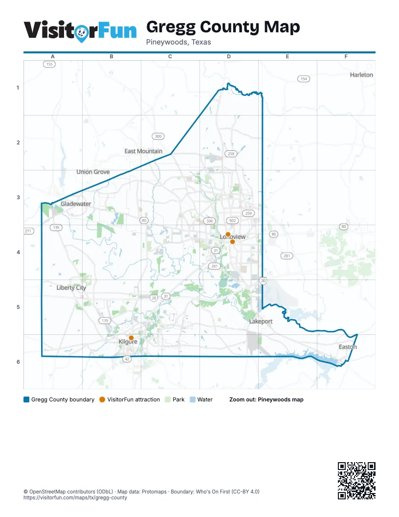
Maps inside Gregg County
2 maps inside, from the street map of Gregg County down.
Street index of Gregg County
Each street on the sheet and the grid squares it crosses.
- West Loop 281C3, D3, C4, D4, D5
- US 259D1, D2, D3
- State Highway 135 NorthB5, B6
- Judson RoadD2, D3, D4
- Gilmer RoadC2, C3, D3, D4
- State Highway 31 NorthC4, C5
- North Eastman RoadD3, D4
- State Highway 135A3, A4, A5, B5
- McCann RoadD2, D3, D4
- State Highway 31 WestB5, A6, B6
- West Marshall AvenueA3, C4, D4
- East Loop 281D3, E3
- Estes ParkwayD4, D5, E5
- East State Highway 31C4, D4
- State Highway 42C3, C4, B5, B6
- Charles K Devall Memorial HighwayC5, C6
- South Eastman RoadD4, E4, D5, E5
- US Highway 259 Business NorthC5, B6, C6
- South Tyler StreetA3
- Houston StreetD4, B6, C6
- East Marshall AvenueD4, E4
- State Highway 31 EastB5, C5, A6
- East Broadway AvenueA3, B3
- South Main StreetA3, D4, F6
- East US Highway 80B3, C3, C4
- TX 322D5, D6
- US Highway 80B3
- North Main StreetA3, B3, F6
- TX 42C4
- South Loop 485A3, B3
- Gardiner Mitchell ParkwayD5
- US Highway 259 NorthC5
- West Upshur AvenueA3
- North High StreetD4
- Northeast Loop 485A3, B3
- West US Highway 80B3
- East Lantrip StreetB6
- Industrial AvenueB6
- South Henderson BoulevardB6
- North Spur 63D4
- North Henderson BoulevardB6
- East Loop 485B3
- Spur 63D3
- East Upshur AvenueA3
- South Spur 63D4
- US Highway 271A3
- Old Kilgore HighwayD4, C5, D5, A6
- FM 349C5, D5
- East George Richey RoadD2, B3, C3, D3
- Pine Tree RoadC3, C4
- North Fourth StreetD3, D4
- Bill Owens ParkwayD3, D4
- H G Mosley ParkwayD3, D4
- East Goforth RoadB5
- Stone RoadB6, C6
- Bill Stoudt ParkwayD2, C3, D3
- North White Oak RoadB3
- West Hawkins ParkwayC3, D3
- Hollybrook DriveD3, E3, B5, C5
- Alpine RoadD3, E3, D4
- South High StreetD4
- South Mobberly AvenueD4
- East Cotton StreetD4, E4
- West Cotton StreetD4
- East Hawkins ParkwayD3
- West George Richey RoadB3
- Dudley RoadB6, C6
- South Access RoadD5, E5
- South Commerce StreetB6
- Vesta AvenueB3
- George Richey RoadB3
- Magnolia LaneB3, D3, B5
- South White Oak RoadB3
- Heritage BoulevardC3
- North Access RoadD5
- North Kilgore StreetB6
- East Main StreetB6
- Campbell StreetB3, C4, B6
- North Commerce StreetB6
- Old Highway 135A4, A5, B5, B6
- FM 1252 WestA5, B5
- Tryon RoadD2, D3, D4
- FM 1844C2, D2
- Kennedy AvenueE6, F6
- Airline RoadD2, D3
- West Harrison RoadC4
- South Martin Luther King Junior BoulevardD4, D5
- Spring Hill RoadC3, D3
- FM 2751D1, D2
- Fritz Swanson RoadB5, B6
- South Green StreetD4, D5
- Eden DriveD3, E3, C6
- FM 2207A4, B4
- IH 20 Service RoadC5, D5
- Danville RoadC5, C6
- FM 1252 EastB5, C5
- North Longview StreetB5, C5, B6
- Post Oak RoadB5, C5
- Texas StreetB3, D4
- Tenneryville RoadC3
- East Whaley StreetD4
- West Sabine StreetD4
- East Young StreetD4, E4
- East Birdsong StreetD4, E4
- Fisher RoadC4
- Reel RoadC3, D3
- Old Tyler HighwayA6, B6
- Old Highway 135 NorthA4, A5
- West Fairmont StreetC3, D3
- East Fairmont StreetD3, D4
- West Birdsong StreetD4
- Blue Ridge ParkwayC3, D3
- Silver Falls RoadC3, C4
- East Tuttle RoadB3, C3
- West Cheryl StreetC3
- Premier RoadC4
- West Pliler Precise RoadD3
- Gum Springs RoadD4, E4
- South Martin StreetB6
- West Garfield DriveD4
- Pegues PlaceD3
- Florence StreetB3, B6
- North Fredonia StreetD4
- Delwood DriveD3
- Dundee RoadC3
- Higginbotham RoadC6
- Scenic DriveC3, C4
- Glencrest LaneD4
- Danville DriveC6
- Easton RoadF6
- I-20 Access RoadA5, B5
- Rice RoadC3, A5
- West South StreetD4
- Enterprise StreetC4, C5
- West Wilkins RoadA4
- West Gay AvenueA3
- East Pliler Precise RoadD3
- Le Duke BoulevardD3
- North Green StreetD4
- Tupelo DriveD4
- East Harris AvenueB6
- Jaycee DriveD4
- East Methvin StreetD4
- Gladewater StreetB6
- Page RoadD3, E3, B6
- Spring Hill ParkwayC3
- I-20 North Access RoadA5
- I 20 Frontage RoadA5, B5
- Pentecost RoadC5, C6
- Avenue BC3, C4
- Access RoadB5
- Birch DriveC3
- West Methvin StreetD4
- Woodcrest LaneD3
- West Whaley StreetD4
- East Lake DriveA3
- Chandler StreetB6
- East Shofner DriveC3, C4
- Old Highway 135 SouthA5
- Hunter StreetB6
- West Lantrip StreetB6
- Johnston StreetD3
- Toledo CircleD4
- West Main StreetB6
- Interstate 20 EastA5
- Plesent Green RoadD5, D6
- Mount Pisgah RoadA5, A6
- County Road 1525D2, D3
- Cherokee Trail NorthE6
- Northridge RoadD1, D2
- River RoadB4, C4, B5
- Magnolia RoadB4, C4, B5
- County Road 3413A5, B5
- County Road 3113A5
- Meadows LaneC5
- Hamby RoadC2, D2
- County Road 1442D1, D2
- Samples RoadA5, B5
- South Twelfth StreetD4
- Lilly StreetD4, D5
- North Fuller RoadC2
- Graystone RoadD2, C3, D3
- Brent RoadC3
- Greggtex RoadC2, C3
- Hunter RoadD1, D2
- North Whatley RoadB3, C3
- Green Blackmon RoadB5, B6
- East Old Highway 80B3, C3
- South Whatley RoadC3
- County Road 296ED5, D6
- Spinks Chapman RoadC5
- Evergreen StreetC3, D3
- Pleas Cocke RoadE6
- Shell Camp RoadB3
- Camp Switch RoadB4, C4
- Cherokee StreetC4
- Peavine RoadB5
- Smallwood RoadA4
- Watson RoadB3, B6
- Merrill Lake RoadB4, C4
- South Fourteenth StreetD4
- Jones RoadC3, E5
- Harley Ridge RoadC3
- Norris RoadC5
- Shiloh RoadB3, C3
- Brown RoadD1
- South Superior RoadB3, B4
- Lonesome Pine RoadD2
- Alliance WayC5
- Garden DriveE6
- Swinging Bridge RoadC4
- Maxey RoadD3, E3
- Mustang DriveD1, D2, A3, C5
- West Bar K Ranch RoadD2
- Country Club RoadA3, A4
- Williams RoadD3, E3, F6
- North Seventh StreetD3, D4
- Hutchings BoulevardD4
- Duncan RoadB3
- Elder Lake RoadC5
- West Whatley RoadB3
- Mackey RoadD1, D2
- Private Road 3456A4, B4
- Centenary DriveD3, D4
- Toler RoadC3, D3
- Greenleaf StreetC3, D3, A4
- Pegues RoadF6
- County Road 1376C2, D2
- Pine StreetD4, A5, B6, E6
- South Fredonia StreetD4
- Private Road 1825D1
- Cherokee TraceB3, B4
- East Wilkins RoadA4, B4
- East Timpson StreetD4
- County Road 3450B5
- Clinton StreetC3
- Clark RoadB4, B5
- Private Road 2095C4
- Sheppard LaneA3, A4
- South Thirteenth StreetD4
- Airport RoadA3, C5
- North Tenth StreetD3, D4
- Hickory LaneE6, F6
- Walnut StreetA4, D4, A5, C5, C6
- Lafamo RoadC3
- North Third StreetD4
- Harvey RoadA5, A6
- Mary Lawson RoadB4, C4
- Cole Bottom RoadA4, B4
- East Melton StreetD4
- Rodden StreetC3, C4
- North Second StreetD4
- Jerry Lucy DriveE6
- Private Road 2310C4
- Celebration WayD3
- Bacle RoadC2, C3
- Old Longview HighwayB3
- Jerry Lucy RoadE6
- East Pacific AvenueA3, B3, D4
- Ronnie Brown RoadA5, B5, B6
- South Center StreetA3, D4
- North Center StreetA3, D4
- Marvin A Smith DriveC5
- Jordan Valley RoadC4
- Richardson StreetA3, D4
- Rabbit Creek DriveB5
- East Lake Devernia RoadB3
- South Sun Camp RoadB3
- Tanglewood DriveC3
- Ruthlynn DriveD3
- Idylwood DriveD4, C6
- Adrian RoadD2, D3
- Northwest DriveC3, D3, D4
- Valentine DriveC4
- Crews RoadA4
- Fuller RoadC2, D2
- Clover LaneD4
- Mockingbird LaneD3, B6
- East Lynwood LaneC3
- Private Road 2146C4
- Rosie Wady RoadA4
- Montclair StreetD3
- East Commerce AvenueA3, B3
- Martin Luther King StreetB5, B6
- Old Highway 31A6
- Spring StreetC3
- Wiley Page RoadD2, E2
- Utzman RoadC5
- Club DriveE4
- Hidden Hills CircleD3
- Steele RoadB5
- Carter RoadA3
- Forest Lake DriveD2
- Massey Rock RoadE5, E6
- Dodd StreetE5, E6
- Green Hills DriveC6
- Alta StreetC3
- D Holland RoadD6
- Leona StreetB3, C3, D4, E4
- Yates DriveD3, D4
Things to do on the Gregg County map
Places on the map
- Allegiance Specialty Hospital
- Cargill Long Park
- Carmela's Magical Santa Land
- Clarksville City
- Crossing Creeks Country Club
- Danville Farms
- Downtown Kilgore
- Duncan Lake
- Easton
- Elder Lake at Synergy Park
- First Baptist Church
- Forest Lake
- French Lake
- Gladewater
- Gladewater Municipal Airport
- Griffin Lake
- Guthrie Park
- Hawkins Crossing
- Judson Middle School
- Kilgore
- Kilgore Airport
- Kilgore High School
- kilgore sports complex
- Lake Devernia
- Lake Harris
- Lake Lamond
- Lake Letourneau
- Lakeport
- Lear Park
- Lonestar Speedway
- Longview
- Longview Country Club
- Longview High School
- North Business Park
- Paul G Boorman Trail Park
- Pine Hill Landfill
- Synergy Business Park
- Tempest Golf Club
- Warren City
- White Oak
Next to Gregg County
- East Mountain
- Harleton
- Union Grove
© OpenStreetMap contributors, Open Database License, openstreetmap.org/copyright · Map data: Protomaps · Boundary: Who's On First (CC-BY 4.0); Quattroshapes (CC BY 2.0)















