

Texas map
La Marque map
About 20,194 people live here (Census Bureau, 2024 estimate). The sheet's index lists 300 streets; Gulf Freeway Frontage Road, Gulf Freeway and Highway 3 cross the most grid squares. Also on it: Carbide Park, La Marque Crossing and Amazon DHT1.
Open the map (PDF, US Letter)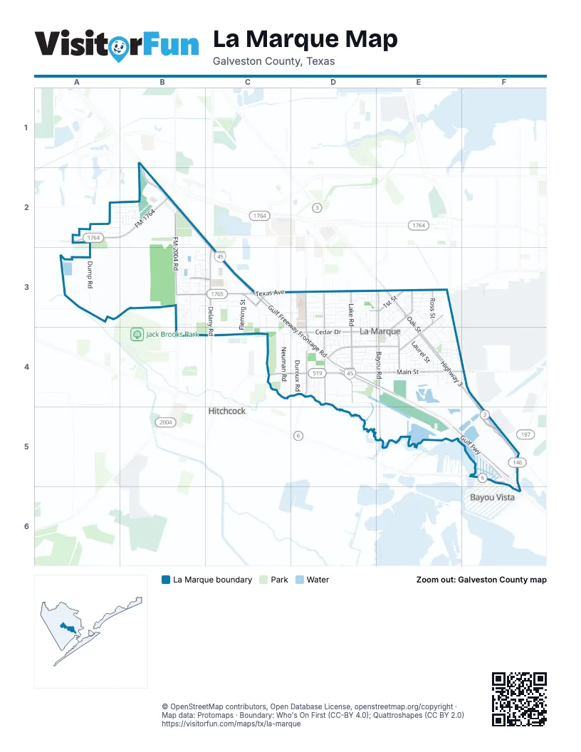
Street index of La Marque
Each street on the sheet and the grid squares it crosses.
- Gulf FreewayC3, D4, E4, E5, F5, F6
- Emmett F Lowry ExpresswayB1, B2
- Highway 3E3, E4, F4, F5
- Highway 146 NorthF5
- FM 1764A2, B2
- Highway 6F5, F6
- Spur 197F5
- FM 2004B2
- Gulf Freeway Frontage RoadB1, B2, C2, C3, D3, D4, E4, E5, F5
- Texas AvenueB3, C3, D3, E3
- Main StreetC4, D4, E4, F4
- FM 2004 RoadB2, B3
- Interstate 45B2
- FM 519F4
- Bayou RoadE3, E4, E5
- Cedar DriveE3, D4, E4
- Lake RoadD3, D4
- Oak StreetE3, E4
- Westward AvenueD3, D4
- Ross StreetE3, E4
- Delany RoadC3, C4
- Magnolia DriveD4, E4
- Vauthier RoadD3, D4
- Howell AvenueE4
- 1st StreetD3, E3
- Meadow Lake Village DriveB3, C3
- Fairwood RoadD4
- Vauthier StreetD4
- Century BoulevardC3
- South Vauthier RoadD3
- Duroux RoadD3, D4
- Laurel StreetE3, E4
- Neuman RoadC3, C4
- Dump RoadA2, A3
- Scott StreetD4, E4
- 3rd AvenueE3, E4
- Maple StreetE3, E4
- Orange StreetE4
- Fleming StreetC3, C4
- Marble Springs LaneB3
- Walnut StreetE4
- Meadow LaneD4
- Westwood CircleA2, B2
- Lawndale StreetC3
- Holly StreetE3, E4
- Prune StreetE4
- Avenue AA2, E3
- North Omega StreetF5
- Volney StreetC3, C4
- Saltgrass PointB3, B4
- Yupon StreetE3, E4
- Honeysuckle DriveE3
- Virginia StreetD3
- Palm AvenueE4
- Azalea DriveE3
- Maxwell StreetD4, E5
- JacksonD3
- 4th AvenueE4
- South Omega StreetF5
- Woodland StreetD4
- 6th AvenueE4
- Garrett StreetC3
- Oaklawn DriveD4, E4
- Rosalee StreetD3
- Kansas StreetD3
- LilacD3, D4
- Shady LaneE3, E4
- Williams DriveC4
- Boss StreetD3
- Plum StreetE4
- Oleander DriveD4, E4
- 5th AvenueE4
- Roosevelt DriveD3, D4
- North Houston DriveD4
- Lamar DriveD4
- South Houston DriveD4
- Austin StreetD4
- Elaine StreetE3
- Pirtle StreetD3, D4
- Avenue DA2, E3
- West Houston DriveD4
- Holman StreetE3
- Albert StreetD3
- 2nd StreetE3
- 12th AvenueE4
- Bluebonnet DriveE3
- Hawks View DriveA2, B2
- WisteriaE3
- Nashby StreetD3, E3
- Dalian StreetE4
- Raymond StreetD3
- StonewallD3
- WalkerC3, C4
- Clark DriveD4
- McKinney ExtendedC3, D3
- Partridge StreetC3
- 11th AvenueE4
- Prairie StreetC4
- Forest Village CircleB3
- Sycamore StreetE4
- Jefferson DriveD3
- Shoshone Ridge DriveA2, B2
- TaylorD3
- McArthurD3
- McKinney DriveD3
- Briar LaneA2, D4
- Turquoise Trade DriveB2
- Avenue BE3
- Newman RoadC3, C4
- Grafton StreetE3
- Winding WayE3
- Hawthorne StreetE4
- Kirby DriveC3
- Casey StreetC3
- Perthius Farms RoadD4
- South Crockett StreetD4
- Mitchell LaneB2
- VeronicaD3, D4
- Edgar StreetD3
- Banana StreetE4
- West Crockett StreetD4
- South Noble RoadC3
- Bowie StreetD4
- Azalea CourtsE3, E4
- Fannin StreetD4
- StrawnC4, D4
- Foreman StreetE4
- Byrd StreetC3
- Robbie StreetE3
- Montgomery StreetE4
- South Garrett StreetC3
- Scenic Lake DriveB3
- Petroleum StreetD3, E3
- Autry RoadB2
- PoplarE4
- Lazy LaneD4
- Apricot StreetE4
- Pear StreetE4
- Willow Harbour LaneB3
- Lenz StreetD4, E4
- South Cobb StreetD3
- Brown DriveD3
- South Rose StreetD3
- Carriage LaneD4
- South Algeria StreetD3
- Hemphill StreetD3
- Garnet Star DriveC3
- Sunset Falls DriveB2
- Bellview StreetD3
- Bogatto StreetD4, E4
- Grassy Knoll TrailB3
- North White HeronF5
- Praire OaksA2
- Lee DriveE4
- Forest Bend LaneB3
- Thompson StreetD3
- Driftwood LaneB3
- Avenue CE3
- Johnson RoadD3
- 10th AvenueE4
- South Pecan DriveE3
- North Flamingo StreetF5
- Clover Bend StreetD4
- Mustang Stampede DriveB2
- Grassy Knoll LaneB3
- Harvest Salt LaneB3, B4
- Naples Terrace LaneB3
- Canton Grass LaneB3
- Praire KnollA2
- Saltgrass Springs LaneB4
- Municipal StreetE4
- PatriciaD3
- Ashley StreetD3
- Lake Park DriveD3
- John StreetD3
- EvergreenD4, E4
- Rosadele StreetD3
- PecosD4
- Florence StreetD4
- Corbett StreetD4
- Montclair Mist LaneB3
- North Campus Heights DriveD3
- North Curlew StreetF5
- StewartD3
- Cedar Gate LaneB3
- Circle DriveE3
- Franklin StreetD4
- Borondo ReachD4
- Elmo StreetE3
- SpruceE3, E4
- 7th AvenueE4
- Century Oaks LaneB3
- Borondo StretchD4
- Indigo Springs LaneB3
- WesterlageE3, E4
- Hathaway StreetE4
- Jeridona StreetD4
- Sand Crab LaneB3
- South Melody DriveD4
- 1st AvenueE4
- Stubbs StreetE4
- Chestnut StreetE3
- CypressE3
- Hackberry StreetE3, E4
- Delmar DriveE4
- Rosedale StreetE3
- Delany Cove CourtB3
- North Camp CircleD3, D4
- Bonham StreetD4
- Hudler StreetD3
- South Campus Heights DriveD3
- Perthuis DriveD4
- 3rd StreetE3
- Merry LaneD4
- Blanchard StreetC3
- IndustrialE3
- North SandpiperF5
- Dewberry RoadB3
- Grebb StreetD4
- LindenD3, D4
- Apple Blossom DriveC3
- Little StreetD4, E4
- Cheyenne River DriveA2
- Rhodora StreetE4
- Layman StreetD3, D4
- BeatriceE3
- Beech StreetE4
- Cherry StreetE4
- Ridgewood Terrace DriveB3
- Splintered Arrow DriveA2, B2
- Robertson StreetD3
- Morning Cypress LaneB3
- Arborglen LaneB3
- Paleos Flint DriveB2
- Apache Field LaneA2
- NeumanE4
- Perthuis Farms RoadD4
- Sunset LaneE3
- Lyric LaneE3
- North SkimmerF5
- Woodhaven AvenueB3
- Spoonbill LaneB3
- Cherry Tree DriveB3, C3
- Bernice StreetC3
- Kirsten StreetD4
- Oakmist Cove LaneB3
- Eriksson AvenueD4
- Parkway DriveB2
- Threlkeld LaneE4
- Ash StreetE4
- Kenneth StreetD3
- 9th AvenueE4
- North MelodyD4
- MurielE3
- Lake Landing DriveB3, C3
- Mar AnnD3
- Steve RoyD3
- Cora StreetD3, D4
- Chip StreetE3
- Possum Trot StreetD4
- Reddingwood LaneC3
- Carolyn StreetE3
- Hutto StreetB2
- Pessara StreetD4
- Franlee StreetE4
- Pine CircleD4
- Lone StarE4
- Margot StreetD3, D4
- DowneyE4
- Pecan Landing LaneB3
- Brookshire StreetD3
- Linton DriveE3
- Retama StreetE3
- Salt Cove CourtB3
- South Justice StreetD3
- Anita StreetD3
- Irene StreetD4
- Pecan RoadE3
- Tallow DriveE3
- Union StreetD3
- Brown StreetD3
- Harlton StreetC3
- Havenstone LaneB3
- Larcom StreetE4
- Lowe StreetE4
- Porter StreetD3
- Preston StreetD3
- Laurelmist LaneB3, C3
- Moss StreetC4
- Burnett StreetD4
- SylviaE4
- Willis CircleD3
- Hoover StreetC3
- Sarlee DriveE4
- Studio DriveE4
- South White HeronF5
- coyote Creek DriveB2
- Laura AvenueE3
- Pacific Point CourtB3
- Sacajewa DriveB2
Places on the map
- Abundant Life Christian School
- Amazon DHT1
- Americas Best Value Inn & Suites-Texas City/La Marque
- Barcena’s Mexican
- Bayou Park
- Bayou Road Elementary School
- Bobby Beach Park
- Carbide Park
- Circle K
- CVS Pharmacy
- Dillon Donuts
- Duroux Church of Christ
- Etheredge Stadium
- First Christian Church
- First United Methodist Church
- First United Methodist Church of Lamarque
- Galveston County Juvenile Justice Alternative Education Program
- Greater Saint Paul Missionary Baptist Church
- Highlands Baptist Church
- IHOP
- Inter City Elementary School
- Jaycee Park
- Kelley’s Country Cookin
- La Marque Cemetery
- La Marque Crossing
- La Marque High School
- La Marque High School Baseball Field
- Mahan Park
- Murphy USA
- Rising Star Cemetery
- Ron Hoover Oasis RV Park
- Ron Hoover RV & Marine of South Houston
- Sam's Club
- Shell
- Shopper's Mart
- Sonic
- St Michaels Episcopal Church
- UPS Customer Center
- Walmart Supercenter
- Whataburger
Next to La Marque
- Bayou Vista
- Hitchcock
© OpenStreetMap contributors, Open Database License, openstreetmap.org/copyright · Map data: Protomaps · Boundary: Who's On First (CC-BY 4.0); Quattroshapes (CC BY 2.0)















