

Texas map
Longview map
About 83,668 people live here (Census Bureau, 2024 estimate). The sheet's index lists 300 streets; West Loop 281, East Loop 281 and Gilmer Road cross the most grid squares. Things to do inside the boundary: Longview Museum of Fine Arts and Northeast Texas.
Open the map (PDF, US Letter)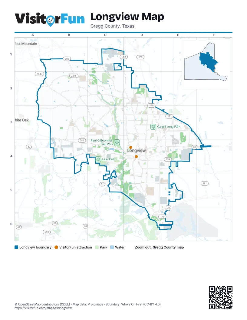
Street index of Longview
Each street on the sheet and the grid squares it crosses.
- West Loop 281C2, D2, B3, C3, B4, C4, C5, D5
- East Loop 281D2, D3, E3, F3, F4
- North Eastman RoadD2, D3, E3, E4
- East Marshall AvenueD4, E4, F4
- Gilmer RoadB1, B2, B3, C3, C4
- Judson RoadD1, D2, D3, D4
- McCann RoadC1, C2, C3, D3, D4
- West Marshall AvenueA3, B3, B4, C4, D4
- South Eastman RoadE4, E5, D6, E6
- East State Highway 31C4, D4, C5
- Estes ParkwayD5, D6
- North High StreetD4
- North Spur 63D4
- Spur 63C2, D2
- East US Highway 80A3
- South Spur 63D4
- Pine Tree RoadA2, B2, B3, B4
- North Fourth StreetD2, D3, D4
- Bill Owens ParkwayC2, C3, C4
- H G Mosley ParkwayC3, D3, C4
- East Cotton StreetD4, E4
- Bill Stoudt ParkwayC1, B2, C2
- West Hawkins ParkwayB2, C2, D2
- South High StreetD4, D5
- South Mobberly AvenueD4, D5
- West Cotton StreetC4, D4
- Alpine RoadE3, D4, E4
- East George Richey RoadA2, B2
- East Hawkins ParkwayD2, E2
- Hollybrook DriveD3, E3
- South Access RoadD6, E6
- Heritage BoulevardB2, C2
- North Access RoadD6, E6
- Magnolia LaneD3
- South Martin Luther King Junior BoulevardD4, E4, D5, D6
- Spring Hill RoadB2, C2, D2
- South Green StreetD4, D5
- Tryon RoadD1, E2, D3, E3, E4
- Eden DriveD3, E3
- Tenneryville RoadB2, A3, B3
- West Harrison RoadB4
- East Whaley StreetD4, E4
- East Young StreetD4, E4
- West Sabine StreetC4, D4, C5
- Airline RoadD2, D3
- East Birdsong StreetD5, E5
- Page RoadE3
- FM 1844C1
- Reel RoadB3, C3
- West Fairmont StreetB3, C3
- East Fairmont StreetC3, D3
- West Birdsong StreetD5
- Blue Ridge ParkwayB3, C3
- Silver Falls RoadB3, B4
- West Cheryl StreetB2
- Fisher RoadB3, B4
- Premier RoadB4
- Delia DriveE3, E4
- West Pliler Precise RoadC1, D1, C2
- West Garfield DriveD5
- Pegues PlaceD3
- North Fredonia StreetD4
- Delwood DriveD3
- Dundee RoadB2, B3
- Scenic DriveB3, B4
- Glencrest LaneC4, D4
- West South StreetD4
- Gum Springs RoadE4
- Industrial DriveE4
- East Pliler Precise RoadD1
- Le Duke BoulevardD3
- North Green StreetD4
- Tupelo DriveD4
- Jaycee DriveC4
- East Methvin StreetD4
- Spring Hill ParkwayB2, C2
- Enterprise StreetC4
- Avenue BC3, C4
- Birch DriveB3
- West Methvin StreetD4
- Woodcrest LaneD3
- West Whaley StreetD4
- East Shofner DriveB3
- Johnston StreetD3
- Toledo CircleC5
- East Tuttle RoadA3
- South Twelfth StreetD4, D5
- Lilly StreetE4, E5
- Graystone RoadB1, C1
- Brent RoadA2, B2
- Greggtex RoadA1, B1, A2, B2
- Evergreen StreetB3, C3
- South Fourteenth StreetD4, D5
- Harley Ridge RoadB2
- North Seventh StreetD3, D4
- Hutchings BoulevardD4, D5
- Centenary DriveC3, D3, C4, D4
- Toler RoadC3
- Cherokee StreetB4, C4
- South Fredonia StreetD4, D5
- East Timpson StreetD4
- Clinton StreetB2, B3
- South Thirteenth StreetD4, D5
- North Tenth StreetD3, D4
- Lafamo RoadA3, B3
- North Third StreetD3, D4
- East Melton StreetD4
- Rodden StreetB3
- North Second StreetD4
- Celebration WayD3
- Greenleaf StreetC3
- Swinging Bridge RoadB4
- Jordan Valley RoadB4
- Legacy ParkwayE5
- Ruthlynn DriveC3, D3
- Richardson StreetC5, D5
- Northwest DriveC3, C4
- Clover LaneD4, D5
- East Lynwood LaneB3
- Montclair StreetC3, D3
- Spring StreetB3
- Hidden Hills CircleC2
- Alta StreetB2
- Yates DriveD3, D4
- Old US Highway 80B3, B4
- Hughey DriveD3, E3, D4
- Lake Lamond RoadC4
- Balsam StreetC2, C3
- Swan StreetB2, B3
- North Sixth StreetD4
- West Avalon AvenueD5
- Baylor DriveC3, D3, C4, D4
- Buckner DriveB3
- Surratt RoadA2
- Buccaneer DriveB3
- Kenwood LaneB3, C3
- Tanglewood DriveA2
- FRJ DriveE4
- Ray StreetC5
- Lake DriveD3, D4
- Fairway Oaks LaneC2
- Garner LaneD3, E3
- Idylwood DriveD5
- Ridgelea AvenueD4
- Oden StreetD4
- Annette DriveB3
- ThorntreeD3
- Palisades BoulevardC3, D3
- Pine StreetD3, D4
- Helane LaneB2
- Mockingbird LaneC3, D3
- Baxley LaneB3
- Fenton RoadB2
- Flanagan DriveD4, D5
- Meadowview RoadA1
- Dumas RoadA2, A3
- North Center StreetD4
- Meadowbrook DriveD3, D4
- Camille DriveB2, C2, B3
- Leota StreetE3, E4
- Triple Creek DriveD3
- Wood PlaceD3
- Trailwood LaneC2
- Sylvan DriveD4
- Noel DriveD4
- South Electra StreetD4
- Hampton CourtD3
- West Niblick StreetB4
- Birdwell LaneB2, C2
- Bramlette LaneD3
- South Fifteenth StreetD4, D5
- Sherwood DriveC3
- South Center StreetD4
- Arkansas StreetE3, E4
- Fairway DriveB3, B4
- Progress BoulevardA4, B4
- North Ninth StreetD3, D4
- Rocking B Ranch RoadA3
- Snoddy RoadB2, B3
- Whispering Pines BoulevardC3
- Emerald DriveC3
- East Buchanan AvenueD4
- East Magrill StreetD4
- Harrison StreetD4
- Whitaker CircleC1, C2
- Holly StreetD5
- McCann Creek RoadB1
- West Tyler StreetD4
- Jones StreetE3, D5
- Rockwall DriveC3, C4
- Hillcrest DriveD3, D4
- Level StreetD5
- Crystal DriveB2
- Castle Ridge DriveB2, C2
- East Nelson StreetD4
- Leona StreetE4
- L L Mackey ParkwayC1, D1
- Lincoln DriveC3
- Cedar Hill RoadE3
- Coleman DriveD3
- Dixon StreetD5
- Millie DriveD5
- North Eighth StreetD3, D4
- Miami DriveD3, D4
- Bates StreetE5
- LeTourneau DriveD5, D6
- North Lane Wells DriveB3, B4
- Princeton AvenueC3, C4
- Marion DriveD4
- Padon StreetD4
- Woodway LaneB2, C2
- East Hope DriveB3
- East Fairlane DriveB3
- Jewel DriveD4, D5
- North Court StreetD4
- Pittman StreetD5, E5
- Heather LaneC3
- Jordan StreetD4, E4
- PALS ParkwayC4
- Tallwood LaneD2, B3
- Mona AvenueE4, F4
- Grand BoulevardC4
- Saint Clair DriveD1
- Wain DriveB2
- Walnut StreetC4, D4
- Lovers LaneC3
- Cook LaneB2, B3
- East College StreetD4
- Harmon DriveD5
- Johnson StreetD5, D6
- Springdale DriveC3
- Stonegate DriveD3
- North First StreetD4
- Thelma StreetB3
- Brownwood DriveD4, D5
- Conroe StreetC4
- West Radio StreetD5
- Diane DriveD5
- Whitney StreetD5, E5
- East Tyler StreetD4
- Lakewood DriveB2, B3
- Bridgers Hill RoadB2
- Bramlette PlaceD3
- Donald DriveB4
- Doyle StreetE3, E4
- John C Murphy WayC1
- Towne Lake DriveC4, D4
- Beaumont StreetE4, E5
- Fleetwood DriveD3
- Wimberly StreetD3
- Rambling RoadC3, C4
- Texas StreetE3, E4
- Northridge DriveC3
- Stegall DriveD5
- Remington TrailB2
- Mickey Melton BoulevardC1
- Missioncreek DriveE3
- Bostic DriveD5
- East Brentwood StreetB3
- Gemi DriveB3, C3
- Glenda DriveD5
- South Houston StreetD4, D5
- West Hope DriveB3
- Willow Springs DriveB4
- Wellington LaneC2
- McBride RoadA3
- Glover DriveD4
- Centenary CircleC3, D3
- West Fairlane DriveB3
- Regency DriveC3
- Graham RoadA2
- Glaske DriveD5
- Stardust StreetB3
- Foundry DriveB4
- Syble LaneB1
- Armond DriveE5
- Castleberry StreetB2
- Pineridge StreetC3
- Duncan StreetB4
- East Berkley StreetB4, C4
- Neal StreetE5
- Columbia DriveC3, C4
- Mohawk StreetE3
- Fuller DriveD5
- Berry LaneD5
- Birdie PlaceB3, B4
- Nell StreetB2, B3
- Kay DriveE4
- Fairview DriveB3
- Hughes StreetD4
- Butler DriveD5
- Mahlow DriveD3, E3
- Chappell StreetD5, E5
- Swancy StreetD5, E5
- Auburn DriveD3
- South Whatley RoadA3
- Sheffield DriveC3, D3
- Delta StreetB3
- Amy StreetD1
- Booker StreetD5, E5
Things to do on the Longview map
Places on the map
- Akin Park
- Bramlette Elementary School
- Bramlette Lake
- Brookwood Village
- Broughton Branch Library
- Broughton Park
- Buckner Westminster Place
- Camille Acres Baptist Church
- Cargill Long Park
- Chaparral Plaza
- CHRISTUS Good Shepherd Medical Center
- City of Longview Compost Site
- Colony Point Office Park
- Contessa Inn
- Cook Lake
- Crossing Creeks Country Club
- East Side Airport
- First Baptist Church
- Guthrie Park
- Hawkins Crossing
- Judson Middle School
- Lake Lamond
- Lear Park
- Longview Business Park
- Longview High School
- Longview Mall
- Longview Towne Crossing
- Lost Creek Business Park
- Marketplace
- McWhorter Park
- North Business Park
- Oceans Behavioral Hospital Of Longview
- Park Place
- Paul G Boorman Trail Park
- Pine Tree High School
- Pine Tree Junior High School
- Pine Tree Schools
- Spring Hill Schools
- Wildwood Lake
- Wood Hollow Golf Course
Next to Longview
- East Mountain
- White Oak
© OpenStreetMap contributors, Open Database License, openstreetmap.org/copyright · Map data: Protomaps · Boundary: Who's On First (CC-BY 4.0); Quattroshapes (CC BY 2.0)















