

Texas map
Mesquite map
About 150,140 people live here (Census Bureau, 2024 estimate). The sheet's index lists 300 streets; Lyndon B. Johnson Freeway, North Town East Boulevard and North Galloway Avenue cross the most grid squares. Things to do inside the boundary: Town East Mall.
Open the map (PDF, US Letter)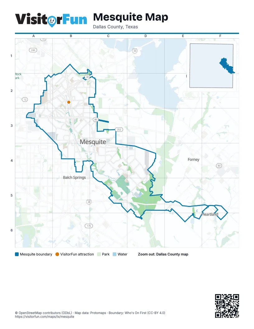
Street index of Mesquite
Each street on the sheet and the grid squares it crosses.
- Lyndon B. Johnson FreewayB1, B2, B3, B4
- Ronald Reagan Memorial HighwayC5, D5
- US Highway 80B3, C3
- Interstate 635 East TEXpressB1, B2
- Military ParkwayB3
- Scyene RoadB3, B4
- North Belt Line RoadC2, C3
- South Belt Line RoadC4
- North Bryan - Belt Line RoadC3
- South Bryan - Belt Line RoadC3, C4
- State Highway 352C3, C4
- East Main StreetC3, C4
- East Davis StreetC3, C4
- West Main StreetB3, C3
- West Davis StreetB3, C3
- North Galloway AvenueB2, B3, C3
- US Highway 80 EastA3, B3, C3
- East Cartwright RoadC4, D4, D5
- Interstate 30A2, B2, A3
- North Town East BoulevardB2, C2, A3, B3
- Gus Thomasson RoadA2, B2, B3
- Faithon P Lucas Senior BoulevardC4, D4, C5
- Clay Mathis RoadC4, D4, D5
- Oates DriveB1, A2, B2
- Northwest DriveB1, B2, C2
- Motley DriveA2, B2, B3
- Lawson RoadD4, C5, D5
- La Prada DriveB1, A2, B2
- Gross RoadA2, B3
- South Town East BoulevardA3, B3
- East Glen BoulevardC4, D4
- Big Town BoulevardA2, A3
- Barnes Bridge RoadB2, C2
- Samuell BoulevardA3
- Pioneer RoadC4
- East Kearney StreetC3
- North Peachtree RoadB3
- Interstate 20C5, D5, F5
- Skyline DriveB3
- West Bruton RoadB4
- West Cartwright RoadB4, C4
- West Kearney StreetB3, C3
- Rodeo Center BoulevardB3, B4
- South Peachtree RoadB3, B4
- Lyndon B. Johnson Service RoadB1, B2
- East US Highway 80C3
- FM 740E5
- South Galloway AvenueC3, C4
- FM 741F5
- Trade Center DriveB3
- Masters DriveB3
- Northwest HighwayB1
- Sorrento DriveA2
- Towne Centre CourtB2
- Bruton RoadB4
- South Gross RoadB3
- Clay RoadC4
- Maylee BoulevardA2
- La Prada Drive EastA2
- North Masters DriveB3
- East Scyene RoadC3, C4, D4
- Newsom RoadC4, D4
- Edwards Church RoadD4, C5, D5
- McKenzie RoadC5
- Berry RoadD4
- Via del NorteB2
- South Parkway BoulevardB3
- East Meadows BoulevardA2, A3
- South Sam Houston RoadB3, B4
- New Market RoadB4, C4
- Hillcrest StreetB3, C3
- Tripp RoadB3, C3
- Mesquite Valley RoadC4
- Towne Centre DriveB2, B3
- Poteet DriveB2, B3
- Bamboo StreetA2, A3, B3
- Shannon RoadC5, D5
- Republic ParkwayB2
- Americana LaneB2, C2, B3
- Modlin StreetA2, B2
- North Mesquite DriveB2, B3
- FM 2757E5, E6
- Twin Oaks DriveC4
- Creek Crossing RoadC4, D4
- Franklin DriveB2, B3
- Hyde Park DriveA2
- East Grubb DriveC3
- West Emporium CircleB2
- Sierra DriveC4
- Ridgeview StreetB3
- Parkwood TrailC4
- Moon DriveA2, B2
- Karla DriveB2
- Childress AvenueB2
- Lumley RoadC5, D5
- Rustown DriveB2, B3
- San Marcus AvenueA2, B2
- West Grubb DriveB3, C3
- Sybil DriveB3
- Towne Crossing BoulevardB2
- Driftwood DriveB2
- Forney RoadA3, B3
- FM 2932F5
- Chapman DriveC4
- North Ebrite StreetC3
- South Walker StreetB3, B4
- North Sam Houston RoadA3, B3
- Baker DriveB3
- Clary DriveB3
- Morningside DriveB2
- Pinehurst LaneB1, B2
- Whitson WayB2
- Carver StreetC3, C4
- Ashwood DriveB2
- Wilkinson RoadC4
- Palos Verdes DriveB2
- Wilkinson DriveC4
- Old Lawson RoadC5
- Edgebrook DriveB2
- Lasater RoadC5
- Rodeo DriveB3, B4
- East Emporium CircleB2
- Via VenturaC2
- Range DriveC3
- Casa Ridge DriveB2
- Parkside DriveB3
- John Glenn ParkwayB2
- Jane StreetB3
- Paza DriveC4
- Oak Brook DriveB3
- Hickory Tree RoadB4
- Anthony DriveA3, B3
- Highland Village DriveB3, C3
- Carriage AvenueD4, D5
- Eulane DriveC4
- East Gross StreetC4
- North Carmack StreetB3
- Eastpoint DriveA3
- Bruton Lane WestC4
- Long Creek RoadC3
- Bruton Lane EastC4
- East Tripp RoadC3
- South Carmack StreetB3, B4
- Columbia ParkwayB2
- Greenbelt ParkwayC1
- Catron DriveA3
- Helms TrailF5
- South Larkin RoadD4
- Royal Crest DriveB3
- Town East MallB2
- Lee StreetB3
- Sarazen DriveA2, B2
- Emerald DriveA2, B2, A3
- Eastbrook DriveB2, A3, B3
- Cantura DriveC4
- Rancho DriveC4
- Flamingo WayA2, A3
- Spiceberry LaneB3
- Casting RidgeC4
- Eastfield ParkwayA2
- Creek Valley RoadC4, D4
- Lindo DriveC4
- Bent Brook DriveD4
- Executive BoulevardA3, B3
- Caladium DriveC4
- Green Canyon DriveB2, C2
- Airport BoulevardD4
- Sidney DriveA2, B2
- Bahamas DriveA2, A3
- Wiser RoadD5, E5
- Independence DriveB2, B3
- Osage TrailC4
- High Country LaneE5, F6
- Cascade StreetB3
- O'Hare DriveC2
- Solterra BoulevardC4
- Kensington DriveA2, B2
- Candleberry DriveB3
- Catalina DriveA3, B3
- Brunswick LaneB3, B4
- Shady Brook LaneE5
- Via AltosB2, C2
- Caribbean DriveA2, B2
- I-20 Frontage RoadE5
- Powell RoadB4
- Picadilly BoulevardB4
- Stillwater DriveD4
- Austin DriveD4
- Leyenda DriveC4
- Quapaw TrailC4
- Larchmont DriveB3
- Greenhill DriveB2, B3
- Alta Vista StreetB3
- Memorial BoulevardB4
- Daisy Hollow LoopC5
- Sandra Lynn DriveA2, B2
- Northridge DriveB3
- Spring Mills RoadC4
- Preston Trail DriveB2
- Statler DriveA2, B2
- Oleander TrailB2
- Griffin LaneF6
- Live Oak DriveB2
- Talia BoulevardE6
- Highland StreetB3
- Riggs CircleB4, C4
- Crestridge StreetB3
- Cavern DriveC5
- Longview StreetB3
- Wooded Lake DriveB2
- Belmont StreetB3
- Rosemont StreetB3
- Willowbrook DriveB3, C3
- Red River StreetB2, B3
- Lakeshore DriveB4, C4
- Buena Vista StreetB3
- Harper DriveB2
- Summit StreetB3, C3
- Sumner DriveC3
- Wildflower LaneC3
- Campbell DriveA3
- Viva DriveA2, B2, B3
- Quail Hollow DriveB2, B3, C3
- Ivy DriveB2
- Ridge Ranch RoadD5
- Ashland DriveC4
- Via del SurB2, C2
- Monticello DriveB3
- Rutherford DriveC4
- Narobi PlaceB4
- Silver Creek DriveD4, D5
- Wheatfield DriveC3
- Lucille DriveB3
- Springwood DriveD4
- Elm Falls PlaceC4
- Richard StreetB3
- West Gross StreetB4, C4
- East Side DriveC4
- Paintbrush StreetC3
- Helen LaneD4
- Cumberland DriveB2, B3
- Belhaven DriveB2, B3
- Nimitz WayC5
- Buckeye DriveC4
- Smokey Mountain TrailC4
- Sea Shell DriveC4
- East Kimbrough StreetC3
- Mark DriveB3
- Hardwood TrailB2, C2
- Spring Lake DriveB4
- Sherwood DriveA2
- Manchester DriveB2
- Bedford DriveB2
- Harvey DriveA2
- Via del ReyB2
- Grand Cayman WayC4
- Via BarcelonaB2
- Chase RoadA3, B3
- Cameron WayC4, C5
- Creekside DriveC4
- Hagan Hill ParkwayC5, D5
- Andrew StreetB3
- West College StreetB4, C4
- Via AvenidaB2, C2
- Clear Creek DriveD4
- Long Shadow LaneC4
- Uvalde StreetB2
- Panola DriveB2
- Windsor DriveC4
- Brazoria DriveB2
- Heatherdale DriveB3, C3
- Aloha DriveA3, B3
- Regent StreetC4
- Trails ParkwayB1
- Homestead DriveD4
- Linhaven DriveB2
- Cool Springs DriveD4
- Beau DriveC4, D4
- Bette DriveC4
- Kiamesha WayA2
- Stallcup DriveB2
- Tierra DriveC4
- Cedar TrailC4
- Audubon ParkB1
- Point East DriveA2, B2
- Potter LaneB4
- Culberson DriveB2
- Sandy LaneB4
- Scottsdale DriveA2
- Junction RunC5
- Shands DriveB2
- Salem DriveB2
- Eastern Heights DriveC4
- Mesquite CemeteryB4, C4
- North ParkwayB3
- Woodcrest DriveB4
- Sesame DriveB3
- Bluebonnet LaneC4
- Dandelion DriveC3
- Woodlawn ParkwayB3
Things to do on the Mesquite map
Places on the map
- B J Smith Elementary School
- Beasley Park
- Bill Blackwood Park
- Broadmoor Plaza
- Broadway Square
- Bruton Park
- C W Beasley Elementary School
- Christian Care Center of Mesquite
- City Lake
- City Lake Park
- City of Mesquite Recycling and Compost Center
- Clay Mathis Park
- Copeland Dog Park
- Cross Elementary School
- Dallas Christian School
- Dallas Regional Medical Center
- DeBusk Park
- Dr James P Terry Middle School
- Dr John D Horn High School
- Eastfield Soccer Complex Trail
- Hillcrest Park
- Hub Group Trucking
- Lakeside RV Park
- LBJ Oates Summit
- Lucas Lake
- Market East Shopping Center
- Mesquite Intermodal Terminal
- Mesquite Metro Airport
- Mesquite Municipal Golf Course
- Mesquite Town Center Plaza
- Paschall Park
- Rorie Galloway Day Camp
- Town East Crossing
- Town East Mall
- Town East Park
- Towne Crossing Shopping Center
- UPS - Mesquite Hub
- Valley Creek Park
- Vista Crossing
- Westover Park
Next to Mesquite
- Balch Springs map
- Forney map
- Heartland
- Heath
© OpenStreetMap contributors, Open Database License, openstreetmap.org/copyright · Map data: Protomaps · Boundary: Who's On First (CC-BY 4.0); Quattroshapes (CC BY 2.0)















