

Texas map
Missouri City map
About 78,582 people live here (Census Bureau, 2024 estimate). The sheet's index lists 300 streets; Texas Parkway, Fort Bend Parkway Toll Road and Cartwright Road cross the most grid squares. Things to do inside the boundary: Ridgeview Park Splash Pad.
Open the map (PDF, US Letter)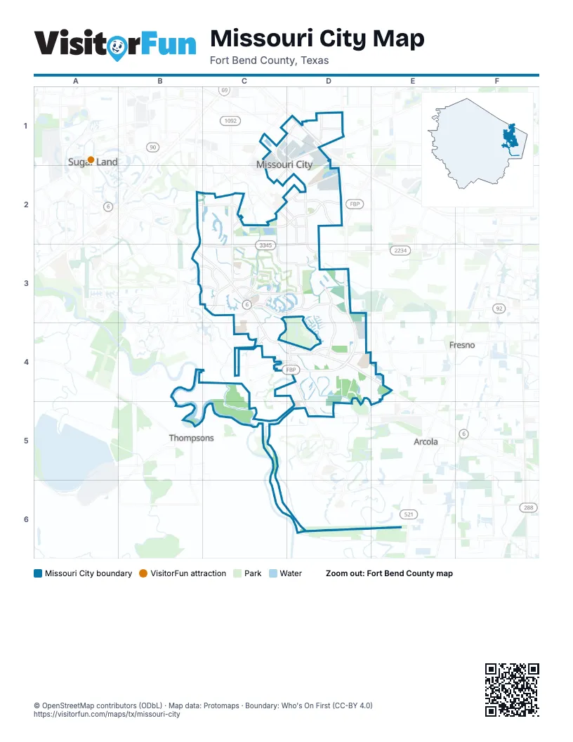
Street index of Missouri City
Each street on the sheet and the grid squares it crosses.
- Fort Bend Parkway Toll RoadD3, C4, D4
- South Sam Houston Tollway WestD1
- Cartwright RoadD2, C3, D3
- Texas ParkwayC1, C2, D2, D3
- Murphy RoadC2, C3
- Sienna ParkwayD4, D5
- Main StreetC1, D1, C2
- South Gessner RoadC1, D1
- Highway 6C3, C4
- State Highway 6 SouthB3, C3
- Texas Highway 6 Frontage RoadD4
- McHard RoadD3
- North Main StreetC2
- South Main StreetC2
- Lake Olympia ParkwayC3, D3
- Independence BoulevardC2, D2
- Lexington BoulevardB2, C2, D2
- Vicksburg BoulevardD3, D4
- South Sam Houston Parkway WestD1
- University BoulevardC3
- Sienna Springs BoulevardC4, D4
- Sienna Ranch RoadC4, D4, D5
- Court RoadC2, D2
- Oilfield RoadC3
- 5th StreetD1, C2, D2
- Fondren RoadD1
- Staffordshire RoadC2, D2
- South Gessner DriveD1
- LJ ParkwayC4
- Glenn Lakes LaneC3, D3
- Trammel-Fresno RoadC4, D4
- Riverstone BoulevardC3
- Turtle Creek DriveD2, C3, D3
- Mc Lain BoulevardD1
- Quail Valley East DriveC2, C3, D3
- Columbia Blue DriveC2, D2, D3
- Hampton DriveC3
- Buffalo RunD2
- Gregory BoulevardD1
- Crow Valley DriveC3
- Knight RoadD4, D5
- Mission Valley DriveD3
- Lakestone BoulevardB3, C3
- Cross Lakes BoulevardB3, C3
- Lakeshore Harbor BoulevardD4
- Parks Edge BoulevardD3
- Fort Bend ParkwayD4
- McKeever RoadC4, D5
- Thomas Taylor ParkwayD2
- Scanlin RoadC2, D2
- Pike RoadC1
- East Creek Club DriveC3
- Misty Hollow DriveD3
- Sienna Christus DriveD4
- Present StreetC2
- Meadowview DriveD3
- Pleasant Valley DriveC3
- Four Winds DriveC3
- Bees Passage RoadD5
- Stoney Brook LaneC3
- McLain BoulevardD1
- Avenue EB2
- Creekstone VillageC3
- Creekstone Crossing DriveC4
- Grand Olympia DriveD3
- Hurricane LaneD3, D4
- Thompson Ferry RoadC3, C4, C5
- Grand Park DriveC2, D2
- Brightwater DriveC2, C3
- Peninsulas DriveC3, C4
- La Quinta DriveC2, C3
- Hilton Head DriveC3, D3
- Watts Plantation RoadD4
- El Dorado BoulevardC3
- Watts Plantation DriveD4, E4
- Dry Creek DriveD3, D4
- Robinson RoadC3
- Shipmans Cove BoulevardD4
- Double Lake DriveB3, C3
- Colonial Lakes DriveC2, C3
- Creek Point LaneD4
- Park Vista DriveD3
- Beekman DriveD4
- Knights CourtC3, C4
- Cumberland DriveD4
- Cravens RoadD1
- Cypress Point DriveC3
- Cicada DriveC3, C4
- Truesdale DriveD4
- West Creek Club DriveC3
- Masters LaneC3, D3
- Point Clear DriveD3
- Raintree DriveC4, D4
- Fairway Pines DriveD2
- Oyster Creek PlaceC4
- Diamond Springs DriveD4
- Argos DriveD3, D4
- Belmont Shore LaneC3
- Fall Meadow DriveC3, D3
- Adams StreetD1, C2, D2
- Hawks RoadD2, D3
- Bermuda Dunes DriveC2, C3
- Palm BoulevardC3
- Aldridge DriveD3, D4
- Island BoulevardC3, D3
- East Hampton CircleD1
- Meadowcreek DriveC2
- Valley Forest DriveC3, D3
- Gentle Bend DriveD2
- Parkview LaneD3
- Ashmont DriveC2
- Ramble Creek DriveD4
- Lakeside Meadow DriveC2
- Mustang Springs DriveC3, D3
- Darby LaneD4, E4
- South Cravens RoadD1, D2
- Silver Ridge BoulevardD5
- Kenforest DriveD2
- Royal Plantation LaneC3
- North Creekmont DriveE4
- Hunters Glen DriveC3, D3
- Hammerwood DriveD2
- Morgan RunD1
- La Costa RoadC3
- Lake Shore Harbour DriveD4
- Crescent Oak DriveD3
- Frenchman's Creek DriveC4
- Sheffield DriveB2, C2
- Oyster Cove DriveC3
- Echo Creek DriveD2
- Rimrock DriveB3, C3
- Memorial Bend BoulevardD3
- Shore View LaneC3
- Heritage Colony DriveB3, C3
- Martin LaneC2
- Cypress Spring DriveB3, C3
- Laurel Green RoadC2
- Lakeshore Forest DriveD3
- Flamingo Island DriveC3, D3
- Chinaberry GroveC4, D4
- Missouri City DriveD2
- Avocet WayD3
- Willow Oak DriveD2
- Creek Terrace DriveC3
- Bluestone DriveC2
- Misty Creek DriveC3
- New Tree LaneD2
- Mustang CrossingD3
- Whispering Pine DriveD2
- Williamsburg LaneC3
- Fondren Grove DriveC1, D1
- Ringrose DriveB2, C2
- Quail Place DriveD2
- Lakewinds DriveC2
- Ridgeview DriveC3
- Palm Harbour DriveD4
- Beechbend DriveD2
- North Garden StreetD1
- Bal HarbourD3, D4
- Township LaneC3
- Park Crest DriveD3
- Driftwood Bend DriveD4, E4
- Woodland Hills DriveC2, D2
- Westshore DriveC2
- Liberty Ridge WayC2, D2
- Christmas RoadD3
- Indian PointD4, D5
- Revolution WayC2
- Quail Meadow DriveD3
- Citypark DriveD1
- Senior StreetC3
- Bonney Briar DriveC3
- Canyon Shore LaneD3
- Timber Creek DriveD3
- Blue Diamond DriveD2
- Chappell LaneC3, D3
- Kiamesha DriveC3
- Westpoint DriveD5
- Rittenmoere DriveD2
- Shoreline DriveC2
- Auburn Grove CircleC3
- Selene DriveD3
- Flamingo Bay DriveC3, D3
- River Rock DriveD2
- Brazos Bend DriveC3
- Stephanie DriveD2
- Lakeside Village DriveC3
- Whippoorwill DriveD2
- Bull LaneD1, D2
- South Creekmont DriveE4
- Stillmeadow DriveC3, D3
- Volterra Lake DriveD3, D4
- Creekway CircleC2
- Middlesbrough LaneB2
- Emerald Lake RoadD4
- Tiny Tree DriveD2
- Waterford DriveC2
- Lake Shore Village DriveD4
- Meadow Green DriveD2
- Crestmont Place LoopD2
- Quail Grove LaneD3
- Mountshire DriveD2
- Oak Forest DriveD3
- Lakewood DriveD4
- Plantation Colony DriveB2, C2
- Freedom Tree DriveD3
- Bright Meadows DriveC2, D2
- Southhampton RoadD4
- Glenford DriveD2
- Wildwood Ridge DriveC2, D2
- Welborn CourtD3, D4
- Wingedfoot DriveC3, D3
- Lake Colony DriveB3, C3
- Edgedale DriveD2
- Springhill DriveC2
- Cherry Springs DriveD3
- Waterfall DriveC2
- Quail Village DriveC2, C3
- Northshore DriveC2
- Derby LaneD2
- Greendale DriveD2
- Sunrise BendC4, D4
- Thunderbird StreetC3
- Kingsbrook LaneC3
- Oyster Creek DriveC4
- Bent Oak DriveD2
- Eastfield DriveD3
- Plymouth Pointe LaneC3
- Valley Manor DriveC2
- Circle Bend DriveD2
- Riva Ridge LaneD1
- Bolton DriveD2
- Tumlinson DriveD4
- Plantation Wood LaneC3
- Shady RiverC3
- Courtside Place DriveD2
- Sienna Springs WayC4
- Clearbrook DriveC3, D3
- Durango BendD4, D5
- East Pebble Beach DriveC3
- Hickory Glen DriveC2, D2
- Colony LaneD5
- Good Day DriveC2
- Plantation Lakes DriveC3
- Lexington CommonC2
- Mossridge DriveD2
- Doverglen DriveD2
- Mckeever LaneD4
- Oakhill DriveC3
- West Pebble Beach DriveC3
- Evans LaneC2, D2
- Lake Villa DriveD4
- Covey TrailC3
- Cherry Creek DriveD3
- Oakwick Forest DriveD4
- Harbourmist DriveC3
- Indigo LaneC3
- Lakeview DriveC3
- Swan Isle BoulevardC3
- Forest Home DriveB2, C2
- Portuguese Bend DriveC3
- Foxglove DriveD2
- Turning Row LaneC3
- South Garden StreetD1
- Foxborough LaneD2
- Palm Grove DriveC3
- Wavertree DriveB2, C2
- Kittybrook LaneD1
- Lakefront DriveC2
- Thomas Jefferson WayC2
- Palm Desert LaneC3
- Dalewood DriveD2
- Grand Falls DriveC2
- Panorama DriveC3, D3
- Fallbrook DriveD3
- Poco DriveD2
- Feather Ridge DriveD2
- Plantation Creek DriveB2, C2
- Sutter Creek TrailC3
- Crystal Ridge StreetD5
- Birchstone DriveC2
- Indian Trail DriveD2
- Duncaster DriveC3
- Flamingo Estates DriveC3, D3
- Village Park DriveC2, D2
- Confederate South DriveD4
- Palmer Plantation DriveC3
- Laleu LaneD1
- Planters View LaneC3
- Everhart Terrace DriveD4, E4
- Glen Park DriveC2
- Roth DriveC3
- Chang-An DriveD1
- Lantern LaneD3
- Pecan Ridge DriveD4
- Cedar Spring DriveC3
- Morning Meadow DriveD2
- Plum Brook LaneC3
- Colony Bend LaneC3
- Greenridge DriveC2
Places on the map
- 7-Eleven
- Advance Auto Parts
- Aldi
- American Canal
- American First National Bank
- American Legion Park
- Auto Check
- AutoZone
- Autumn Leaves of Riverstone
- Baines Middle School
- Buffalo Run Park
- Community Park
- E A Jones Elementary School
- Elkins High School
- Fort Bend County Libraries - Missouri City Branch
- Frost Lake
- Hightower High School
- HomeTowne at Missouri City
- Hunters Glen Elementary
- Hunters Glen Park
- Independence Park
- Lake Olympia Middle School
- MacNaughton Park
- Marshall High School
- MCMS Stadium Walkway
- Missouri City City Hall
- Missouri City Middle School
- Mosley Park
- Palmer Elementary
- Quail Valley El Dorado Course
- Quail Valley Golf Course
- Quail Valley La Quinta Course
- Quail Valley Middle School
- Ridgeview Park
- Roane Park
- Sonal Bhuchar Elementary
- StaMo Sports Park
- The UPS Store
- United States Post Office
- Walmart Supercenter
Next to Missouri City
- Arcola
- Fresno
- Palmetto
- Sugar Land map
- Thompsons
© OpenStreetMap contributors, Open Database License, openstreetmap.org/copyright · Map data: Protomaps · Boundary: Who's On First (CC-BY 4.0); Quattroshapes (CC BY 2.0)















