

Texas map
Palestine map
About 19,583 people live here (Census Bureau, 2024 estimate). The sheet's index lists 300 streets; West Oak Street, Loop 256 and Crockett Road cross the most grid squares. Also on it: Palestine Municipal Airport, City Lake Park and Wolf Creek Lake Park.
Open the map (PDF, US Letter)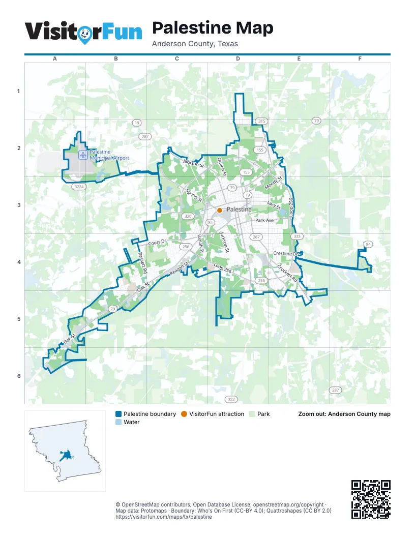
Street index of Palestine
Each street on the sheet and the grid squares it crosses.
- West Oak StreetC3, D3, B4, C4, A5, B5
- Loop 256C2, D2, E2, C3, E3, E4
- South Loop 256C4, D4, E4
- Crockett RoadD3, D4, E4, E5
- West Spring StreetC2, C3, D3
- North Link StreetD2, D3
- West Palestine AvenueC3, D3, C4
- North Loop 256C3, C4
- Court DriveB4, C4
- East Palestine AvenueD2, E2, D3
- State Highway 155D2, D3
- East Park AvenueD3, E3
- North Church StreetD3
- North Mallard StreetD3
- East Spring StreetD3
- US Highway 79A6
- Yeager StreetC4
- South Sycamore StreetD3, D4, D5
- South Magnolia StreetD3, D4
- Gardner DriveD2, E2
- Martin Luther King BoulevardC3
- Farm-to-Market Road 3224A2, A3
- Avenue AD3
- West Colorado StreetD4
- West Reagan StreetD3, C4, D4, B5
- North Jackson StreetC2, D2, D3
- East Lacy StreetD3, E3
- West Lacy StreetC3, D3
- County Road 421B2
- Old Elkhart RoadE4
- Newman StreetD2, E2, D3
- Benbrook DriveE4, E5
- Country Club RoadD2
- West Gillespie RoadD4
- McNeil StreetC3, C4
- Harcrow Road (CR 2101)C4, D4
- Perry StreetD3
- Knox StreetC4
- M L Cary StreetC3, D4
- West Park AvenueD3
- County Road 403D2
- Old Palestine RoadE4
- Crawford StreetD3
- County Road 420B2
- County Road 417C2
- West Point Tap RoadB4, C4, B5
- Salt Works RoadC3, D3, B4, C4
- North Queen StreetD2, D3
- Armory RoadC2, C3
- South Jackson StreetD3, D4
- Upper Lake RoadC3
- East Murchison StreetD3, E3
- Bassett RoadB4, C4
- East Neches StreetD3, E3
- East Brazos StreetD3, E3
- South Royall StreetD3, D4
- Crestline DriveD4, E4
- South Royal StreetD4, D5
- West Carolina StreetC3, D3
- Moody StreetE2, D3, E3
- North Variah StreetC3, C4
- North Tennessee AvenueD3
- East Angelina StreetD3, E3
- North Sycamore StreetD3
- South Dorrance StreetD3, D4
- Park Road 70F4
- West Debard StreetC3, D3
- South Micheaux AvenueD3, D4
- North Howard StreetD3
- South Sylvan AvenueD3, D4
- West Hamlett StreetC3, D3
- East Reagan StreetD3
- North Fort StreetC3, D3
- Wolf Creek Lake RoadB2, B3
- South Variah StreetC4
- West Kolstad StreetD3
- North John StreetD3
- North Conrad StreetD2, D3
- North Esplanade StreetD3
- Venture ViewD1
- Rambling RoadD3, E3, D4
- Old Brushy Creek RoadD2
- East Crawford StreetD3
- Timberline TrailD1
- West Green StreetD3
- East Lamar StreetD3, E3
- Trail Hollow LaneE4
- Inwood DriveD4, E4
- Cedar Vale Meadows Mobile Home RoadB5
- North Cottage AvenueD3
- South Fulton StreetD3, D4
- West Coronaca StreetD3
- Ferguson RoadC4
- Willow Creek ParkwayD4, D5
- Woodland DriveD3, E3
- Tile Factory RoadB4, B5
- Brierwood DriveE4
- Glenwood DriveE3, E4
- Florence StreetB5
- Brookview LaneB4
- Longhorn DriveD4, D5
- Peach Tree DriveD2, E2
- Sanderson Farms ParkwayB5
- Fay Way DriveE4, E5
- Lakeshore DriveE3, E4
- East Calhoun StreetD3, E3
- Turner DriveD2, E2
- West Cook StreetD4
- North Cedar StreetD3
- Evergreen DriveB4, B5
- Range RoadD4, D5, E5
- West Louisiana StreetD3
- Brookhollow DriveA5, B5
- Thomas RoadC4
- Old Tucker TrailA5, B5
- East Huffsmith StreetD4
- Head StreetD3
- East Market StreetD3
- Chancellor DriveB3, C4
- North Virginia AvenueC2, C3
- West Campbell StreetD3, D4
- County Road 429A2, A3
- Shamrock DriveB4, B5
- West Swanitz StreetD3
- Ben Milam RoadE4
- Tate StreetD4
- Drexel StreetD2
- Meadowbrook DriveD2
- Memory LaneE4, E5
- Hilltop DriveD4, E4
- North Texas AvenueD3
- West Main StreetD3
- West Burkitt StreetD4
- Ridgewood DriveC4
- West Brooklyn AvenueD3
- North Conway StreetD3
- East Kolstad StreetD3
- Avenue CC4
- Willow Creek DriveD4, D5
- Larry StreetC3, C4
- Tyler StreetD2
- West Giraud StreetD3
- Avenue BC4
- North Fowler StreetD3
- South Grove StreetD3, D4
- Wesley DriveE4, E5
- County Road 2203A5
- San Jacinto StreetD3
- Richland DriveE4, E5
- West Dye StreetD3, D4
- South May StreetD3
- Kickapoo StreetD2, D3
- Birch StreetD3
- South Hood StreetD3
- Covert StreetC3, D3
- North Texas StreetC3
- BentwoodD1
- Yorkshire BoulevardC4
- Juniper DriveB4
- Palmer DriveD4
- Clover LaneB5
- Sandy LaneD4
- Palm DriveB4
- Daniels StreetD2, E2
- West Broyles StreetD4
- East Poplar StreetD3
- North Fannin StreetD3
- Highland DriveD4, E4
- Swanson DriveD4, E4
- Greever StreetD2, E2
- West South StreetD3
- Palestine ParkF4
- Southview StreetE4
- Perry Tap RoadC2
- Parkcrest DriveC4
- Chestnut DriveC4
- Chism DriveB4, B5
- Indian Creek DriveE3
- East Pine StreetD3
- Maverick DriveD4, E4, D5
- 2nd StreetC4
- East Jolly StreetD4
- Trimble StreetE2
- Linden DriveB4
- Stephanie DriveD2
- Woodridge RoadB5
- Sheridan DriveC4
- Ragland StreetD2, E2
- Cedarvale StreetB5
- Lakeview AvenueE3
- West Eilenstein StreetC3
- North Magnolia StreetD3
- East Colorado StreetD3, D4
- Buttermilk DriveB4
- Fitzhugh StreetD2, E2
- South Bowie StreetD3
- Holmes StreetC4
- Willowbrook WayD1
- Brakenridge StreetE3
- Forest DriveE3
- Anderson DriveE3
- Gay DriveD4
- Sugar LaneE4
- Blanton RoadC4
- Lelia StreetC4
- North Elm StreetD3
- McCollough StreetD3
- Medical DriveD4
- Ricky DriveD2
- Sunset RoadD4
- Moore DriveE4
- 4th StreetC4
- North Missouri StreetC3
- South Dowling StreetE3
- 5th StreetC4
- Avenue DC4
- Hamilton RoadE3, E4
- Dove RidgeB5
- Sherry LaneD2
- 6th StreetC4
- Fort Houston DriveC4
- Lipsey AvenueC4
- Cummings StreetD4
- West Maffitt StreetD2
- Nannie LaneE4
- West Illinois StreetD3
- Ludolph StreetD2
- Kenny DriveD2
- Sierra DriveD4, E4
- Larkspur LaneB4, B5
- Woodside DriveC4
- Sequoia DriveB5
- Shady Oaks DriveC3, C4
- Berkely DriveE4
- Threll StreetC2
- Lori LaneD1, D2
- Hays StreetD3, E3
- Shadow Wood DriveC4
- Caplin StreetE2
- Craig DriveC3, C4
- Wall DriveC2
- Clearview DriveC4
- Coffee StreetD2
- Oakhurst DriveE4
- Bermuda LaneB4
- Edna DriveB4
- Nixon StreetC2
- Bristol RoadC4
- Lisa LaneD2
- Hillcrest DriveE4
- Garland StreetD3, E3
- Victory StreetC3, C4
- Joe Louis StreetC3, C4
- Lowe StreetC3, C4
- Callier StreetC3, C4
- SpringdaleB4
- Daisy LaneE5
- South Ross StreetD3
- Del Mar StreetD3
- Mustang DriveD4, D5
- Westwood RoadC4
- West Gooch StreetD3
- Future StreetC3, D3
- Ravine DriveE4
- Golfcrest DriveD2
- West Van Fleet StreetD3
- Leram StreetB4, C4
- North Hurst StreetD3
- Rogers StreetE3
- Monica LaneD1, D2
- Melissa DriveD1, D2
- North Dechard StreetD3
- Settlers CourtE4
- County Road 2146A6
- County Road 415C2
- Mitze LaneD1, D2
- Romallen DriveC4
- Columbia StreetC3
- West Georgia StreetC3
- Donniebrook DriveD2
- Marion StreetD2
- Industrial BoulevardC4
- West Angelina StreetD3
- Hiltop DriveE4
- Hood StreetD3, D4
- Aleta DriveE4
- West Kentucky StreetD4
- Douglas StreetC3
- West Crawford StreetD3
- West Ohio StreetD4
- Youpon DriveE5
- East DallasD3
- County Road 2145A5, A6
- Post Oak LaneC4
- 7th StreetC4
- East Hodges StreetD3
- South Hickory StreetD4
- West Dallas StreetD3
- Middleton StreetC4
- WindridgeB5
Places on the map
- 1855 Restaurant & Saloon
- Air Force Memorial
- Aldi
- Anderson Sheriffs Office
- Anderson County Annex
- Anderson County Courthouse
- Applebee's
- Austin Bank
- Blue Lake
- City Cemetery
- City Lake Park
- Copper Safe Storage
- Downtown
- East Hill Cemetery
- Gillispie Park
- Green Park
- Joyce Lake
- Lower City Lake
- Memorial Cemetery
- Northside Primary School
- Old Town
- Palestine Carnegie Library
- Palestine High School
- Palestine Mall
- Palestine Middle School
- Palestine Municipal Airport
- PYAA Sports Complex
- Reagan Park
- Saint Josephs Cemetery
- Southside Elementary School
- Spring Park Lake
- Steven Bennett Park
- Story Elementary School
- Texas State Railroad
- The Plaza
- Upper City Lake
- Walmart Supercenter
- Wildcat Golf Course
- Wolf Creek Lake
- Wolf Creek Lake Park
© OpenStreetMap contributors, Open Database License, openstreetmap.org/copyright · Map data: Protomaps · Boundary: Who's On First (CC-BY 4.0); Quattroshapes (CC BY 2.0)















