

Texas map
Anderson County map
About 59,512 people live here (Census Bureau, 2024 estimate). The sheet's index lists 300 streets; State Highway 155, North US Highway 287 and North State Highway 19 cross the most grid squares. Things to do inside the boundary: Palestine.
Open the map (PDF, US Letter)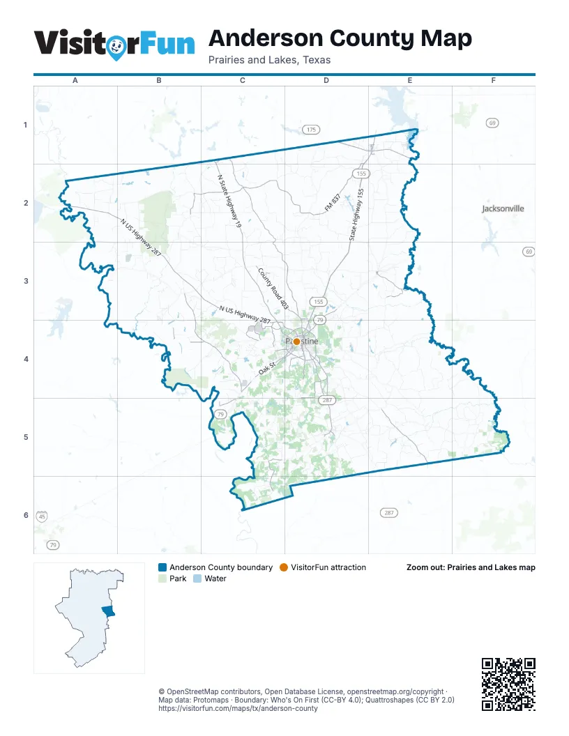
Maps inside Anderson County
1 map inside, from the street map of Anderson County down.
Street index of Anderson County
Each street on the sheet and the grid squares it crosses.
- State Highway 155D1, E1, D2, D3, D4
- North US Highway 287A2, B2, B3, C3, C4
- North State Highway 19C1, C2, C3, C4
- Crockett RoadD4, D5
- US Highway 175D1, E1
- West Oak StreetC4, D4
- Loop 256D4
- South Loop 256D4
- West Spring StreetC4, D4
- North US Highway 79D3, D4
- North Link StreetD3, D4
- West Palestine AvenueD4
- North Loop 256D4
- Court DriveC4, D4
- East Palestine AvenueD4
- North Frankston HighwayE1
- East Park AvenueD4
- US Highway 79C4
- East Pine StreetE1, D4
- West Pine StreetD1, E1, D4
- North Elm StreetE1, D4
- North Church StreetD4
- West Parker StreetD5
- North Mallard StreetD4
- East Parker StreetD5
- East Spring StreetD4
- South Elm StreetE1
- US Highway 175 EastD1
- Yeager StreetD4
- State Highway 19 SouthC1
- East FM 837D1, C2, D2
- Farm-to-Market Road 645B3, B4, C4
- Farm-to-Market Road 2022E5
- West FM 837B2, C2
- Farm-to-Market Road 3224C3, C4
- South Sycamore StreetD4
- FM 322D4
- South Magnolia StreetD4
- Gardner DriveD4
- Martin Luther King BoulevardC4, D4
- Avenue AD4
- West Colorado StreetD4
- FM 315 SouthD1
- County Road 404C1, C2, C3, D3
- County Road 403C3, D3
- County Road 354E3
- Old Elkhart RoadD4, D5
- Old Conco RoadC3, D3
- County Road 118C5, C6
- West Reagan StreetC4, D4
- County Road 422C4
- Beulah Community RoadD4, D5
- County Road 420C4
- Farm-to-Market Road 3328B4, C4
- North Jackson StreetC4, D4
- County Road 2933C5
- Harcrow Road (CR 2101)D4
- County Road 421C4
- County Road 140D4
- East Lacy StreetD4
- Benbrook DriveD4
- County Road 419C4
- West Lacy StreetD4
- County Road 417C4
- Kickapoo StreetE1, D4
- Perry StreetE1, D4
- Newman StreetD4
- Country Club RoadD3
- West Gillespie RoadD4
- South MainD5
- McNeil StreetD4
- Front State RouteE3
- Commerce StreetE1, E3
- Knox StreetD4
- Red Town RoadD5
- M L Cary StreetD4
- West Park AvenueD4
- Neches StreetE3
- Old Palestine RoadD4
- Crawford StreetD4
- FM 2574D3
- County Road 1259E4, F4, F5
- County Road 1227E4
- County Road 468B2, C2
- County Road 103D5, D6
- County Road 323E2
- County Road 494A2
- County Road 448C3, D3
- Broyles Chapel RoadC3, C4
- County Road 370D3, D4
- County Road 314D2
- County Road 493A2
- Union Hope RoadE4, E5
- County Road 473B2
- County Road 441C2, D2, D3
- County Road 335E2, D3, E3
- County Road 445C2, D2
- County Road 336D2, E2
- County Road 312D1
- County Road 355E3, E4
- County Road 471B2
- County Road 486C1, C2
- County Road 309E1, E2
- County Road 2601A2, B2, A3, B3
- County Road 2101C4, D4, C5
- County Road 2608A3, B3
- Old Boston RoadD4, E4, E5
- County Road 460C2, C3
- County Road 453C2, C3
- County Road 386D4, E4
- County Road 435D2
- County Road 2402B3, C3
- Alderbranch RoadE4
- County Road 430C3
- County Road 349D3
- Langston RoadE4
- County Road 489B1, B2
- County Road 1222F5
- County Road 2405C3
- County Road 318D2, E2
- County Road 2202C4
- County Road 2901B4, C4
- County Road 1220E5, F5
- County Road 119C6
- Engling Wildlife RoadB2, B3
- County Road 481C2, D2
- County Road 1214F5
- County Road 320E2
- County Road 1209E5
- County Road 475B2
- County Road 1219F5
- County Road 2701B3
- County Road 452C2, C3
- County Road 2301C3
- County Road 432D2, C3, D3
- County Road 2303C3
- County Road 482D1, D2
- County Road 338E2, E3
- County Road 396D4, E4
- County Road 1229E4
- County Road 463B2, C2, C3
- County Road 379D3, D4
- County Road 1226E4, F4, F5
- County Road 174E5
- County Road 182D5, E5
- AN County Road 353E3
- County Road 130D5
- County Road 100D5, D6
- County Road 2504B3
- County Road 485C1, C2
- County Road 441 NorthD3
- County Road 2110C5
- Salt Works RoadC4, D4
- John Starr RoadD5
- County Road 185D5, E5
- County Road 358D3
- County Road 450C2, C3
- County Road 466C2
- County Road 488C2
- County Road 2401B3, C3
- County Road 359D3
- County Road 391E4
- West Point Tap RoadC4, D4
- County Road 397E4
- County Road 385D4
- County Road 1225E4, F4
- County Road 442D3
- County Road 367D3, D4
- County Road 412C3
- County Road 2904C4
- County Road 474B2, B3
- County Road 458C2, C3
- County Road 437D2
- County Road 1232E4
- County Road 451C3
- County Road 117C6
- County Road 2217B3, C3
- Fincher RoadD5
- Lakeside DriveD2, C3, D4
- County Road 2136C5
- County Road 346E3
- County Road 1230E4
- County Road 447D2
- County Road 1212F5
- County Road 163D5, E5
- County Road 1228E4
- County Road 376 WestD3, D4
- County Road 1208E5
- County Road 2133C5
- Blue Ribbon RoadD5
- County Road 305E1
- Camp Hill RoadD4, D5
- County Road 492A2
- County Road 1206E5
- County Road 480D2
- County Road 2413C3
- County Road 491A2, B2
- County Road 170D5
- County Road 1224E4, E5
- County Road 199E4
- County Road 2907C4
- County Road 476B2
- County Road 465C2
- County Road 319D2
- County Road 2109C5, D5
- Middle Crockett RoadD4
- County Road 2610B3
- James Curtis Ranch DriveD4
- County Road 2122C5
- County Road 469B2, C2
- County Road 181E5
- Killian RoadE5
- County Road 327D2
- Cow Track Ranch RoadC4
- Private Road 6294C5
- Slocum RoadE5
- County Road 352D3
- County Road 2809B3, B4
- County Road 483D1, D2
- Cronin Switch RoadD4, D5
- County Road 499A2, B2
- County Road 179E5
- County Road 156D4
- County Road 477AD2
- County Road 329E2
- County Road 2419B2, B3
- County Road 2409C3
- County Road 2218B3, C3
- Day RoadD5
- County Road 2802B3
- County Road 341D3, E3
- County Road 127C5
- County Road 2213C4
- Old Alcoa Plant RoadD3
- County Road 125C5
- County Road 478D1
- County Road 363D3
- County Road 2812B4
- County Road 413C3
- County Road 425C4
- County Road 1215F5
- County Road 300D1
- County Road 150D4
- County Road 467C2
- County Road 472B2
- Bad Bad RoadA3, B3
- County Road 370 EastD3
- Levee RoadB4
- County Road 2803B3
- County Road 1217F5
- County Road 408C3
- County Road 415C3, D3, D4
- County Road 449C2
- County Road 147D4
- County Road 2123C5
- South Hill RoadD4
- County Road 436D2
- County Road 171D5
- North Queen StreetD4
- Range RoadD4
- County Road 2111C5
- County Road 496A2
- County Road 484C1, D1, D2
- County Road 4528C1
- County Road 2206C4
- County Road 326E2
- County Road 334E2
- Armory RoadD4
- County Road 311D1, E1
- County Road 108D5, D6
- County Road 2107C5, D5
- Miller RoadD5
- County Road 153D4
- County Road 315E1, E2
- County Road 459C2
- County Road 414C3
- South Jackson StreetD4
- County Road 487C2
- County Road 4034D3, D4
- Wildcat Ferry RoadC3
- County Road 2606A3, B3
- County Road 2140D4
- County Road 462B2, B3
- County Road 465 NorthC2
- County Road 321E2
- Stafford Farm RoadC3
- County Road 383D4
- Upper Lake RoadC4, D4
- County Road 3051E1
- County Road 397 EastE3, E4
- County Road 122C5
- County Road 4049C2
- County Road 1213F5
- County Road 101D5
- Quick RoadC2
- County Road 356E3
- Bonners Ferry RoadD5
- Caddo DriveD3, E5
- County Road 114D5
- Mosier RoadC4
Things to do on the Anderson County map
Places on the map
- Alex Patel Scoccer Complex
- Bass Haven Lake
- Beaver Marsh
- Big Lake
- Big Lake Bottom WMA
- Broyles Lake
- Calhoun Lake Number 1
- Canny1
- Canny2
- Carroll / Spring Lake
- Catfish Lake
- Cedar Lake
- Charles E Ham Lake
- Circle R Lake Number 1
- Circle R Lake Number 2
- City Lake Park
- Clear Lake
- Crystal Lake
- Davey Dogwood Park
- Elkhart
- Evergreen Marsh
- Fisherman Paradise Lake
- Frankston
- Grover C Walker Lake
- Gus Engeling Wildlife Management Area
- Gus Engeling WRDA
- Haverlah Lake
- Ioni Lake
- Lake Dogwood
- Lake Francis
- Lake Frankston
- Lakeview Assembly
- Long Lake
- Lost Prairie Lake
- M.A. Davey Lake
- Old Salt Works Lake
- Palestine
- Palestine Municipal Airport
- Pineywoods Lake
- Wolf Creek Lake Park
Next to Anderson County
© OpenStreetMap contributors, Open Database License, openstreetmap.org/copyright · Map data: Protomaps · Boundary: Who's On First (CC-BY 4.0); Quattroshapes (CC BY 2.0)















