

Texas map
Robertson County map
About 17,659 people live here (Census Bureau, 2024 estimate). The sheet's index lists 300 streets; North State Highway 6, North Main Street and East Old San Antonio Road cross the most grid squares. Things to do inside the boundary: Camp Hearne.
Open the map (PDF, US Letter)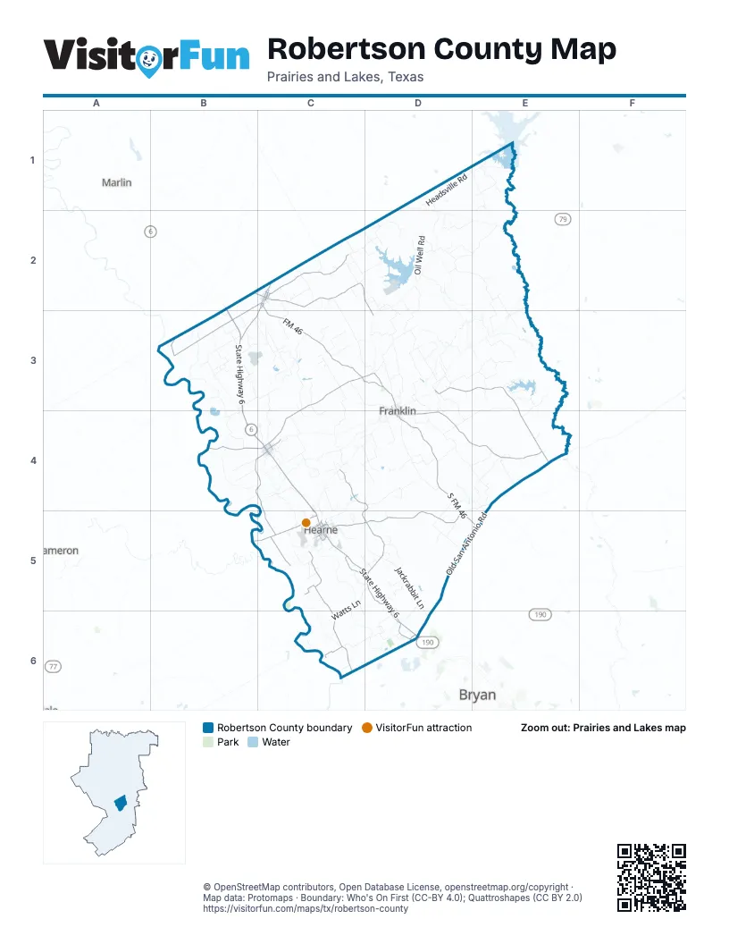
Street index of Robertson County
Each street on the sheet and the grid squares it crosses.
- North State Highway 6B2, B3, B4, C4, C5, D6
- South State Highway 6C5, D5, D6
- South State Highway 14C2, B3, C3
- South Main StreetC2, C4, D4
- North Main StreetC2, D3, B4, C4, D4
- North Market StreetC2, C5
- South Market StreetC2, C5
- North State Highway 14C2
- West Brown StreetC5
- North Commerce StreetC2
- South Commerce StreetC2
- State Highway 6 SouthB2
- East Old San Antonio RoadE4, D5, E5, D6
- FM 46C2, C3, D3
- Farm-to-Market Road 2446D4, E4
- Farm-to-Market Road 1940D3, E3, E4
- Farm-to-Market Road 979C3, B4, C4
- Farm-to-Market Road 391C5, D5
- South FM 46D4, D5, E5
- Farm-to-Market Road 50C5, C6
- Farm-to-Market Road 485B5, C5
- Browning StreetB4, C4
- Farm-to-Market Road 46B2, C2
- Franklin RoadC4
- East Brown StreetC5
- South Wheelock StreetD4
- East Hanna StreetC4
- North Bremond StreetD3, D4
- Owensville RoadD3
- West Decherd StreetD4
- West Collins StreetC2
- East Grant StreetD4
- Main StreetC2, D3
- West Old San Antonio RoadD6
- Collins StreetC2
- Farm-to-Market Road 2549C4, D4, C5, D5
- Farm-to-Market Road 2293C2, D2, D3
- Farm-to-Market Road 1373B2, C2, B3
- Old Hearne RoadC5, D5, D6
- Farm-to-Market Road 1644B4, C4, C5
- Farm-to-Market Road 2954C2
- Marris LaneC3, D3
- Cedar StreetD3, C4, C5
- Foyt RoadC6
- Muse RoadC5
- Norwood LaneC5
- North Hearne StreetD3, D4
- West 9th StreetC5
- South San Jose StreetC5
- Spur 231D6
- Blackshear StreetC5
- Maple StreetC4
- Wildcat RoadB4, C4
- Rose Marie BoulevardC5
- West Texas StreetC4
- Hackberry StreetC5
- East 4th StreetC5
- Moss AvenueC5
- Franklin StreetC5
- North Anderson StreetC2
- Lamar StreetC2
- Fulton StreetC5
- West Brenken StreetC5
- North Alamo StreetC5
- West 5th StreetC5
- South Alamo StreetC5
- North San Jose StreetC5
- East Collins StreetC2
- San Saba StreetC2
- Rabbit LaneD6
- West San SabaC2
- Macey RoadE4
- Old Hickory Grove RoadD4, E4
- Mumford-Benchley RoadC6, D6
- Henry Prairie RoadD4
- Oil Well RoadD1, D2
- East Boone Prairie RoadD2, D3
- Jackrabbit LaneD5, D6
- Cole Branch RoadD2, E2
- Rose Hill RoadC3
- White Rock RoadC2, D2
- Camp Cooley RoadD2, E2
- Owensville Cemetery RoadC3, D3
- Mitch McMillan RoadC4, D4
- Headsville RoadD1, E1
- Walker Prairie RoadE3, D4, E4
- Gourd Neck LoopE3
- Little Mississippi Cemetery RoadC3, D3
- Watts LaneC5, D5, C6
- North Tidwell Prairie RoadB3, C3
- Dogwood Creek RoadE1
- Hoxie Chapel RoadE3
- Sunnyside RoadC3, C4
- West Henry Prairie RoadC4, C5
- Camp Arrow Moon RoadD5
- Grant Prairie RoadD3
- Sadberry RoadD6
- Shiloh Church RoadE4
- Tidwell RoadC3
- Old HighwayB3
- County Road 339D3, D4
- Railroad RoadC2, D3
- Puckett Ranch RoadD3
- County Road 129C3, C4
- Dunns Fort RoadD5
- Willow Creek RoadD1, D2
- County Road 386D3
- Merryman RoadD2, D3
- Nesbit RoadC3
- Prairie Grove RoadC2, D2
- Bartkowiak RoadB3
- County Road 384D3
- County Road 477D2
- Queen I RoadC3
- Trojacek RoadC3
- Jack Brewer RoadC4
- Internal Ranch RoadE4
- Hawhart RoadD3, E3
- South Tidwell Prairie RoadB3, C3
- Cedar Creek RoadD4, E4, D5
- Old Boones Prairie RoadD3
- Pin Oak RoadD4
- County Road 228D4
- County Road 118C4
- Mud Creek RoadC4
- Red Rock RoadD3
- Walnut Cemetery RoadC2
- East Boones Prairie RoadD3
- Beck Prairie RoadC3
- James Cemetery RoadE3, E4
- J C Reagan RoadD2, E2
- County Road 123B3, C3
- Wasik RoadC2
- Lehoski RoadB3
- Riley Green RoadE3
- Cobb Branch RoadE3
- Matajka RoadE4
- Yastic RoadB3
- Harbor Bolton RoadE4
- Wildcat Bridget RoadB4
- Krowinberger RoadC3
- County Road 476D2, E2
- County Road 133C3
- McNutt RoadD4
- County Road 333E3, E4
- Redbank Creek RoadC2
- West H Warren RoadC5
- South Hickory LoopC4
- Richard Hailey RoadC3
- Gillam RoadD2, D3
- Providence RoadC4
- Hughes CutoffD4, D5
- Morgan LaneD4
- County Road 116B4
- Hammond RoadB3
- New Magnolia Church RoadB4
- Peach Joe RoadC2, C3
- Schubyrch-Antis RoadC2, C3
- Barrville RoadC4
- Taylor RoadD5
- Brazos River Auth RoadE1
- Harless LaneC4, C5
- Carroll Bashinski Road 426B3, C3
- Edwards LaneC3, D3
- Calhoun RoadD5
- County Road 336E3
- River Ridge RoadC5, D5
- Mount Vernon RoadC3, C4
- Kitty Kat LaneD3
- South San Gabriel StreetC5
- Holly Cemetery RoadE2, E3
- Winding RoadC5
- Leamon RoadD3
- Old Boone Prairie RoadD3
- County Road 361D3
- Mc Carver RoadC5, D5
- Hayes Church RoadD3
- Vitera Sand RoadC2
- New Baden-Mt Pleasant RoadD3, D4
- Vaughn LaneC5
- Old Franklin HighwayC4, C5
- Brunette RoadE3
- Elmo RoadC4
- County Road 325D4
- McCormick RoadD3, D4
- Railroad StreetC4, C5
- Reistino Gin RoadC6
- John Cotton RoadB3
- County Road 387D3
- Cotropia RoadC5
- Pine StreetE1, C4, C5
- Jesse Cope RoadD5
- Clyde Acord RoadE3
- County Road 471D2
- Mushinski - BudziseB3
- Scottys LaneD4
- Grassy Lake RoadE3
- Anderson LaneB4
- North Edwards RoadD4
- Bishopville RoadC4, D4
- Steele RoadB3
- Jack Rabbit LaneD5
- County Road 122C4
- Andreski RoadC2
- Camp Creek Cemetery RoadE3
- Lee Chapel RoadC5, C6, D6
- Rolke Ranch RoadE3
- McGee RoadD4
- Post Oak StreetC4, C5
- East B Watson RoadC2, D2
- Perrone RoadC5
- Mount Calvary RoadC4
- Mr Smith RoadD4
- Reeves RoadE2, E3
- County Road 450C2
- Morehead RoadC2
- Milstead RoadD2
- County Road 372E2, E3
- Lone Star LaneD3
- Ray RoadD2
- Deer Trail RunC4
- Cooks RoadB3
- Red Hill RoadC4
- Saunders RoadD3
- J W Martine RoadC4
- Fire Station RoadD3, E3
- Bench RoadB3
- Hill Top LaneD1
- George Wachel RoadB3
- Henry Prairie Church RoadD4
- Hickory LoopE1
- County Road 348E3
- Dunns Fort Cemetery RoadD5
- Taylor LaneC4, D4
- Buckswart RoadD4
- Catalina RoadC5
- Williamstown RoadC4
- Winstead LaneC4
- Reagan LoopD2
- Barton Farm RoadB4
- Hartley LaneE1, E2
- North Owensville StreetD3
- Box Center RoadB3
- County Road 468D2
- County Road 366E1
- Edwards RoadD4
- Franks RoadB3
- South Owensville StreetD3, D4
- Pin Oak StreetC4, C5
- Camp Creek Water Dist RoadE3
- County Road 346D3
- Nelson RoadC4
- Sterling Robertson Dam RoadE1
- Cooper LaneC4
- Sycamore LaneE1
- Old Mumford RoadC5
- South Magnolia StreetC5
- Milchell RoadD2
- M L King Jr StreetC4
- Willow StreetC5
- Springer RoadB3
- Hunter RoadC4
- Wheelock StreetC5
- Crennan LaneC5
- County Road 303D5
- Maxwell RoadD2
- Hopcus RoadB3
- Sansom Cemetery RoadE1
- Embra RoadD3
- Post Oak LoopE1
- Tony's Crossing RoadC5
- East Texas StreetC4
- West Davis StreetC5
- West Boone Prairie RoadD2, D3
- Henson LaneC4, C5
- Kelly LaneC3
- South Austin RoadC6
- Steves RoadB3, C3
- Beech StreetC4
- Elm StreetC4
- Magnolia StreetC4
- Bucksnort RoadD4
- Hardin Slough Road 412B3
- Buza RoadB3
- Winn RoadD2
- Cal Davis RoadC4
- West 10th StreetC5
- Hall LaneD2
- Lakeway DriveD5, D6
- Nuelda RoadC2
- County Road 340D3, D4
- East Mitchell StreetC4
- Jones LaneD4, D5
- China StreetC4
- Kennedy LaneD2
- Cottonwood StreetC4
- Calvert StreetC5
- Anderson StreetC5
- South San Felipe StreetC5
- Cypress StreetC5
Things to do on the Robertson County map
Places on the map
- Abraham Lake
- Arrowhead Shooting Range
- Artesian Lake
- Blackshear School (CLOSED)
- Bob Jones Park
- Bremond
- Calvert
- Calvert Beauty Cemetery
- Calvert City Hall
- Calvert Mine
- Camp Arrowmoon
- Camp Creek Cemetery
- Camp Creek Lake
- Casey Lake
- Corpora Airstrip
- County Road 122
- Franklin
- Franklin Cemetery
- Franklin High School
- Franklin Middle School
- Franklin Post Office
- Franklin Ranch Community Park
- Greater Riverside Cemetery
- Hearne
- Hearne High School
- Hearne Municipal Airport
- Hearne Municipal Golf Course
- Hearne Shopping Center
- Lion Stadium
- Love's Travel Stop
- Macedonia Cemetery
- McGuire Lakes Number 1
- McGuire Lakes Number 2
- Norwood Cemetery
- Robertson Lake
- Savoy-Gant Lake
- Schultz Lake
- Seale Lake
- Twin Oaks Reservoir
- Wayne-Sanderson Farms Feed Mill
Next to Robertson County
- Bryan map
- Cameron
- Marlin
© OpenStreetMap contributors, Open Database License, openstreetmap.org/copyright · Map data: Protomaps · Boundary: Who's On First (CC-BY 4.0); Quattroshapes (CC BY 2.0)















