

Texas map
Bryan map
About 91,541 people live here (Census Bureau, 2024 estimate). The sheet's index lists 300 streets; North Earl Rudder Freeway, North Earl Rudder Freeway Frontage Road and North Harvey Mitchell Parkway cross the most grid squares. Also on it: Coulter Field, Henderson Park and Miramont Country Club.
Open the map (PDF, US Letter)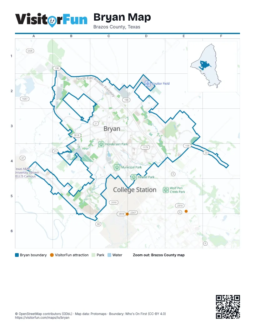
Street index of Bryan
Each street on the sheet and the grid squares it crosses.
- North Earl Rudder FreewayB1, B2, C2, C3, D3, D4
- North Earl Rudder Freeway Frontage RoadB1, B2, C2, C3, D3, D4
- North Harvey Mitchell ParkwayB1, B2, B3, B4, C4, C5
- John Sharp ParkwayA4, A5, B5, B6, C6
- Texas Avenue SouthC3, C4, D4
- Boonville RoadD3, E3, E4
- East William J Bryan ParkwayC3, D3
- East State Highway 21C2, D2, C3
- North Texas AvenueB2, C2, C3
- San Jacinto AvenueC3
- University Drive EastE3, E4
- Texas Avenue NorthC3
- West State Highway 21B3, C3
- Farm-to-Market Road 158E4
- Harvey Mitchell Parkway Frontage RoadC4, C5
- West William J Bryan ParkwayC3
- North State Highway 6B1
- West Villa Maria RoadC4, B5, C5
- East 29th StreetC3, C4, D4
- East Villa Maria RoadD3, C4, D4
- Briarcrest DriveD3, D4
- South College AvenueC4, D4, D5
- Sandy Point RoadB3, C3
- Tabor RoadC2, C3
- Wellborn RoadC4, C5, D5
- Harvey RoadE4
- Copperfield DriveE3, E4
- Austin's Colony ParkwayD3
- Carter Creek ParkwayC3, C4, D4
- Old Hearne RoadB2, C2, C3
- Finfeather RoadC3, C4
- Broadmoor DriveD3, D4
- West 28th StreetB3, C3
- Cavitt AvenueC4, D4
- Beck StreetC3, B4, C4
- Leonard RoadB4, C4, B5
- South Traditions DriveB5, C5
- Barak LaneD4
- Old Reliance RoadD2, D3
- Health Science Center ParkwayC5, C6
- Thornberry DriveD3
- East Martin Luther King Junior StreetC3, D3
- North Traditions DriveB5, C5
- Palasota DriveC3, C4
- Mumford RoadB2
- West Martin Luther King Junior StreetC3
- Woodville RoadB2, C2
- Groesbeck StreetC3, C4
- North Sims AvenueC3
- East 23rd StreetC3
- North Main StreetC3
- South Coulter DriveC3, C4
- Austins Estates DriveD2, D3
- South Main StreetC3, C4
- Canterbury DriveE3
- Woodcrest DriveE3, E4
- Wallis RoadD2
- Green Valley DriveD3, E3, E4
- Wilkes StreetC2
- Elaine DriveC2
- Old College RoadC4, C5
- Bullinger Creek DriveD3
- Saunders StreetC3
- West Carson StreetC4
- North Bryan AvenueC3
- North Coulter DriveC3
- Ursuline AvenueC3, D3
- East 32nd StreetC3
- Turkey Creek RoadC4, C5
- Briar Oaks DriveD4
- Nash StreetD3
- Osborn LaneD3
- West 23rd StreetC3
- Freedom BoulevardD4
- South Bryan AvenueC3
- Traditions BoulevardB5
- Oak Hill DriveD4
- Rabbit LaneC2
- Cambridge DriveD4
- South Sims AvenueC3
- East North AvenueD4
- Graham DriveB3, C3
- Sulphur Springs RoadC4, D4
- Windridge DriveD4
- West 29th StreetC3
- East Oak Hill DriveE4
- Bruin TraceC3
- East Carson StreetC4
- West Dodge StreetC4
- Elmo Weedon RoadE4
- West North AvenueC4, D4
- Willis Vanhook DriveC4
- F & B RoadC5
- Westwood MainC4, C5
- Pendleton DriveE3, E4
- Stevens DriveC2
- Silver Hill RoadA4, A5
- Industrial BoulevardB4
- Waco StreetC3
- Shiloh AvenueB4
- Miramont CircleE3
- Midtown Park BoulevardC4
- West 27th StreetC3
- Old Kurten RoadC2, C3
- East 27th StreetC3
- Oakmont BoulevardE3
- East 31st StreetC3, C4
- East 26th StreetC3
- Nuches LaneC2
- Maloney AvenueC4, D4
- Wayside DriveC4, D4
- Jones RoadB5
- West 24th StreetC3
- East 28th StreetC3
- West 17th StreetC3
- East 25th StreetC3, D3
- Kent StreetC4, D4
- North Washington AvenueC3
- West 18th StreetC3
- Clarks LaneC2
- Fountain AvenueC4
- Oak Ridge DriveD4
- Tanglewood DriveD4
- East 30th StreetC3
- Forestwood DriveC4
- Positano LoopD2
- East 21st StreetC3
- North Rosemary DriveD4
- North Parker AvenueC3
- Miramont BoulevardD3, E3
- Hickory Ridge CircleB5, C5
- South Rosemary DriveD4
- Meadowbrook DriveD3, E3, D4, E4
- Hall StreetC3
- Prairie DriveD3
- Brompton LaneE3
- West 26th StreetC3
- Esther BoulevardC4, D4
- Memorial DriveD3, D4
- Gooseneck DriveC2, D2
- Suncrest StreetB3, B4
- Kingsgate DriveB5
- Laura LaneC2
- North Sterling AvenueC3
- Wilhelm DriveC2
- Hillside DriveD4
- Park Meadow LaneE4
- Colson RoadC2
- Echols StreetC4
- Camelot DriveD3, D4
- Stone City DriveB4
- Concordia DriveE3
- South Gordon StreetC3, C4
- West 22nd StreetC3
- South Ennis StreetC3
- Wildflower DriveD3
- East 24th StreetC3
- West 16th StreetC3
- Winchester DriveE3
- East Brookside DriveD4
- Bittle LaneC4
- Cottage Grove CircleC4
- Stone Meadow CircleC2
- West Briargate DriveD3
- North Houston AvenueC3
- Rustling Oaks DriveD3, D4
- Bennett StreetC3, C4
- North Tabor AvenueC3
- Dansby StreetC3
- North Logan AvenueC3
- Ravenwood DriveE3, E4
- East 22nd StreetC3
- Warwick LaneE3
- Edgewood DriveD4
- Maroon Creek DriveE3
- Kebler PassE3
- North Preston AvenueC3
- Berry Branch LnF4
- Stillmeadow DriveD4
- Settlers WayD3
- Phil Gramm BoulevardB2
- Russell DriveC2
- South Haswell DriveC3
- Lightfoot LaneC2
- East Dodge StreetC3, C4
- Fox River LaneE3
- Courtlandt PlaceE3
- Cross Park DriveE4
- Dellwood StreetC4, D4
- Momentum BoulevardE4
- Boulevard StreetC3
- Bristol StreetC4, D4
- Capitol ParkwayB2
- Parkway TerraceD4
- West 21st StreetC3
- Archer DriveD3
- Pecan Ridge DriveD3
- Tatum StreetB3, C3
- Woodland DriveC4
- Crossing DriveC4
- Richard StreetC4
- Fairway DriveC4
- Henderson StreetC3
- South Hutchins StreetC3
- Williamson DriveC4
- Rock Hollow LoopC4
- Silkwood DriveB4, C4
- La Brisa DriveC5
- North Polk AvenueC3
- North Thornberry DriveC2, D2
- Nagle StreetC4, D5
- Marino RoadD2
- Pecan StreetC3, C4
- Winding CreekF4
- Independence AvenueB3, B4
- Marquis DriveC4
- North Randolph AvenueC3
- Hensel AvenueD4
- Acadia LoE3, E4
- Shirley DriveC2
- West Pruitt StreetC3
- South Baker AvenueC3
- College View DriveD4
- East Briargate DriveD3
- Austins LandingD2
- Shirewood DriveC5
- College Main StreetC5, D5
- Mary Lake DriveD4
- Varsity Oak CrB5
- Avondale AvenueC4
- Providence AvenueB4
- Eastchester DriveE4
- Krenek'sC4
- Clark StreetD2
- Commerce StreetC3
- Rollins AvenueC3
- Bryant StreetC3
- Long DriveD3
- Club RoadC5
- Heron Lakes DriveE3
- Tiffany Park CircleE4
- Lincoln StreetD2
- Quail Hollow DriveD3, D4
- Charles AvenueC2
- South Tabor AvenueC3
- Bonham DriveC2
- Oklahoma AvenueC2
- Live Oak StreetC2, C3
- Old Oaks DriveD4
- Inwood DriveD4
- Windsor DriveD4
- Emory Oak DriveC5
- Roughneck DriveC2
- Brook Hollow DriveC4
- Louis StreetB3
- Ehlinger DriveC4
- Burt StreetC3
- Missouri AvenueC2
- Enfield StreetD4
- Mitchell StreetC4, D4
- Red Robin LoopD3
- Willow Oak StreetE3
- Brighton DriveE4
- Pierce StreetC3
- Hummingbird CircleC5
- Sharon DriveC4
- Greenstone WayE3
- Tee DriveC4
- Arbor DriveD3
- Chelsea CircleE3
- Garden Acres BoulevardD4
- Clearleaf DriveB4, C4
- Knightsbridge LaneE3
- Goodson Bend RoadA4
- Margaret Rudder PikewayD2
- Harper LaneC4
- Lazy LaneD4
- Luza StreetC3, D3
- Highland DriveC4
- Meadow LaneD4
- Cartwright StreetB3
- Fourth StreetD4
- Lynn DriveC4
- Weaver StreetC3
- East Pruitt StreetC3
- Allen Forest DriveD3
- East 33rd StreetC3, C4
- Thorndyke LaneB3
- Highpoint DriveD3
- Messenger WayC2
- Wellington AvenueC3
- Water Oak StreetC2, C3
- Lakeside StreetC4
- Trophy DriveD3
- North Congress StreetC3
- Fowler DriveB5
- Skrivanek DriveC4, D4
- Embers LoopD3
- Porters WayC2
- Crescent DriveD4
Places on the map
- Allen Academy
- Anson Jones Elementary School
- Arbor Oaks at Crestview
- Arthur L. Davila Middle School
- Austin's Colony Park
- Bonham Elementary School
- Bonham Park
- Boonville Cemetery
- Brazos Christian School
- Brazos County Detention Center
- Bryan City Cemetery
- Bryan Collegiate High School
- Bryan High School
- Bryan Regional Athletic Complex
- Camelot Park
- CHI Saint Joseph Health Regional Hospital
- City Course at the Phillips Event Center
- Coulter Field
- Country Club Lake
- Crockett Elementary School
- Federal Park
- Federal Prison Camp, Bryan
- Finfeather Lake
- Goodman Aggie Golf Complex
- Grandview Cemetery
- Henderson Elementary School
- Henderson Park
- J. W. Hamilton Unit
- Jane Long Middle School
- Kemp Carver Elementary School
- Lowe's
- Miramont Country Club
- Municipal Park
- Park Hudson
- Rudder High School
- Steele-Milburn Field
- Tejas Center
- The Physicians Centre Hospital
- Towne Centre
Next to Bryan
© OpenStreetMap contributors, Open Database License, openstreetmap.org/copyright · Map data: Protomaps · Boundary: Who's On First (CC-BY 4.0); Quattroshapes (CC BY 2.0)















