

Texas map
Rockwall map
About 53,547 people live here (Census Bureau, 2024 estimate). The sheet's index lists 300 streets; Congressman Ralph Hall Highway, North John King Boulevard and East Interstate 30 cross the most grid squares. Also on it: Caruth Lake, Rockwall Technology Park and Boles Lake.
Open the map (PDF, US Letter)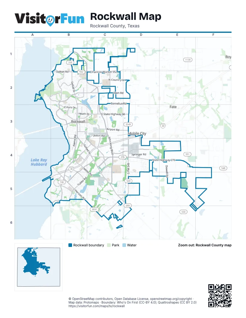
Street index of Rockwall
Each street on the sheet and the grid squares it crosses.
- Congressman Ralph Hall HighwayD3, B4, C4, D4, A5, B5
- North John King BoulevardB1, C1, B2, C2, C3
- State Highway 276C4, D4, E4
- South John King BoulevardC3, C4, C5
- South Goliad StreetB3, B4, C4, C5
- North Goliad StreetB1, B2, B3
- South State Highway 205C5, D5
- East State Highway 66C3, D3
- South Alamo RoadB3, B4
- Williams StreetB3, C3
- West Rusk StreetB3
- North Fannin StreetB3
- East Washington StreetB3, C3
- North Alamo RoadB3
- South Fannin StreetB3
- East Rusk StreetB3
- West Washington StreetB3
- Olive StreetB3
- East Interstate 30D3, B4, C4, D4, B5
- Ridge RoadB3, B4, B5
- North Lakeshore DriveB2, B3
- Horizon RoadB5, C5, C6
- South FM 549D4, C5, D5
- North Stodghill RoadD2, D3
- East Farm to Market 552B2, C2
- East Ralph Hall ParkwayB4, C4, B5
- Corporate CrossingD4
- West Ralph Hall ParkwayB5
- South Farm to Market 549C5, C6
- Village DriveB4, B5
- Stodghill RoadD3
- Dickson LaneB2
- Future South FM 549C5
- Discovery BoulevardC4, D4
- East Quail Run RoadB2, C2
- Justin RoadC3, D3, B4, C4
- Shores BoulevardA2, B2
- South Lakeshore DriveB3, B4
- Tubbs RoadB5
- Farm to Market 1141C2, C3
- West Yellow Jacket LaneB4, C4
- Airport RoadC3, D3
- North T L Townsend DriveB3, B4, C4
- Summer Lee DriveB5
- Mims RoadB4, C5
- T L Townsend DriveC4
- Featherstone DriveB2
- Caruth DriveB2, B3, C3
- Highland DriveB2, B3
- Ridge Road WestB2
- East Fork DriveB3
- Dalton RoadB2
- Memorial DriveB2
- Industrial BoulevardC3, C4
- Henry M Chandler DriveB5
- Market Center DriveB4, B5
- Southwestern DriveB3
- Farm to Market Road 1139D5
- Champions DriveA2, B2
- Heath StreetB3, C3
- Summit Ridge DriveB3, B4
- Walnut Ridge DriveC4, C5
- White RoadB5
- East Boydstun AvenueB3
- Faircrest DriveC4
- Green CircleE4
- Steger Towne RoadB5
- Greencrest BoulevardB4
- Kyle DriveB4
- East Yellow Jacket LaneC4
- Trailview DriveC4
- Commodore PlazaB5
- North West StreetB3
- Masters BoulevardB2
- Tandem TrailE4
- Boydstun StreetB3
- Yacht Club DriveA5, B5
- Stableglen DriveC4, D4, C5
- Lakeside DriveB4, B5
- Rochell RoadD4
- Breezy Hill LaneC1, C2
- Dowell RoadE4, E5
- H Wallace LaneC5, C6
- North Country LaneC2, D2
- Springer RoadD4
- Sunset Hill DriveA3, B3
- Clem RoadC2, D2
- South Clark StreetB3
- Bordeaux DriveB2
- Cornelius RoadC2, D2
- Wylie LaneC6, D6
- Hays LaneB2, C2
- Randas WayB2, C2
- County Line RoadB5, C5
- Petaluma DriveB2, B3
- Jeff Boyd RoadC6
- Olmsted DriveC5, D5
- Saddlebrook LaneC2
- Rockwall ParkwayB5
- Ralph DriveE5
- Plummer DriveB2
- Laguna DriveB4, B5
- East Cullins RoadC6
- Hunt LaneB1, B2
- Park Place BoulevardB3, C3
- Anna Cade RoadC1, C2
- Selborne DriveC5, D5
- Lake Meadows DriveB3
- Arcadia WayB3
- Twin Lakes BoulevardD4
- Terraces BoulevardC2, C3
- Nash StreetB3
- Columbia DriveA5, B5
- Guadalupe DriveD4, D5
- Hickory Creek LaneC4
- Oak DriveB5
- Grand AvenueC3
- Harvard DriveB2
- Brahma DriveE5
- Ranger DriveA5, B5
- Ashbourne DriveB2
- Data DriveD4
- Midnight PassB2, B3
- National DriveC5
- Capital BoulevardD4
- Wimberley LaneD5
- Waldo DriveE5
- Calm Crest DriveB1, C1
- Trout RoadB5
- Cobblestone DriveC2
- Lake Forest DriveB2, A3, B3
- Eva PlaceB5, C5
- Turtle Cove BoulevardB4
- Misty Ridge LaneC5
- Perch RoadB5
- Fieldcrest DriveC4
- Highview LaneB3
- Stoney Hollow LaneC2
- Zollner RoadE4, E5
- Tannerson DriveC2
- Geary DriveB2
- Sids RoadC4, C5
- West Boydstun AvenueB3
- Lofland CircleC5
- Bear Claw LaneC5
- Bass RoadB5
- Rolling Meadows DriveC3, D3
- Stonebridge DriveB3
- Monterey DriveB3
- Renee DriveC5
- Innovation StreetC4
- Miramar DriveB2
- Lone Star DriveE5, F5
- Blanche DriveC5
- Chris DriveC5
- Lynne DriveC5
- Yvonne DriveC5
- Forest TraceB3
- Phoenix LaneC2
- Wayne DriveC5
- Russell DriveC5
- Nicole DriveC5
- Nautilus DriveB2
- West Quail Run RoadB2
- Fontanna BoulevardD4, D5
- Stone Creek DriveB2
- Avonlea DriveB2
- Crestbrook DriveB2
- Calistoga DriveB2, B3
- Coastal DriveA2
- York DriveB2
- Ravenbank DriveC1
- Greenway DriveB2
- East Kaufman StreetB3
- Pegasus LaneC2
- Bayshore DriveB3
- Windjammer LaneB4, B5
- Deer Ridge DriveC4, C5
- Lorion DriveB1, C1
- Renfro StreetB3, C3
- Amherst DriveB2
- Wallace RoadC5
- North Hills DriveB3
- Old Millwood RoadD1
- Fairlakes Pointe DriveB2
- Life Spring DriveB1
- Glenn AvenueB3
- Crescent Cove DriveC2
- Tobias LaneD5
- Lazy Brooke DriveB1, C1
- Deverson DriveB2
- Westway DriveB3
- Potter AvenueB2
- Nakoma DriveB2
- Evans RoadC5
- Shoretrail DriveB3
- North Clark StreetB3
- Meandering WayB2
- Glenwick DriveC4
- Shoreview DriveB3
- Singing Water DriveB1, C1
- Panhandle DriveC2
- Primrose LaneB4, B5
- Clairmount DriveC2
- Sausalito DriveB2
- Aluminum Plant RoadC3
- Shadydale LaneB5
- Stewart DriveC4
- Ridgecross DriveC1
- Phelps Lake DriveC2
- Signal Ridge PlaceA5, B5
- Windham DriveB1
- Wildwood LaneB3
- Mountcastle DriveB2
- Ranch Trail RoadC5
- Montrose DriveB2, C2
- Woodcreek DriveB5
- Madison DriveC4
- Waters Edge DriveC3
- Saint Marys StreetB3
- Ketten DriveB1
- Topaz DriveB2
- Lochspring DriveC4
- Ridgeview DriveB3
- Kenway DriveB3
- Sam Houston StreetB3, B4
- Willow BendB3
- Draco DriveC2
- Sceptre DriveB5
- Hillcroft DriveA2, B2
- Mesa Verde DriveD4
- Brockway DriveB5
- Teagle DriveC4
- Wind Hill RoadB2
- Harborview DriveA5, B5
- Storrs StreetB3
- Wickersham RoadC2
- Joe White StreetB3
- Pleasant View DriveB1, C1
- Boyett LaneD2
- Windsong LaneB5
- Broken Lance LaneC5
- Desert Falls LaneB2
- Jackson StreetB3
- Harvester DriveC4, D4
- White Water LaneC2
- Hunters GlenB5
- Parkland ValleyC3
- Bay Hill DriveB3
- Diamond Way DriveD4
- Sky Harbor DriveC1
- Sylan Park DriveC5
- Gumbo DriveE4
- Coolwood LaneC5
- Juniper Hills DriveD4
- Miranda LaneC2
- Lookuot DriveC3
- Canyon DriveC3
- East Old Quail Run RoadC2
- Hidden ValleyB2
- Granite Falls DriveC2
- Holden DriveB1
- Euclid DriveC2
- Zion Hills CircleD3
- Herrick StreetC5
- Shady Lane DriveC2, C3
- Emerson DriveB2
- Lago Vista LaneB5
- Barrymore DriveB2
- Pine Valley DriveC2
- Inman StreetC5
- WillowcrestC5, C6
- Harbor Landing DriveB5
- Timber Creek DriveD4
- Bexar StreetD5
- Hampton Bay DriveC2, C3
- Skylar DriveB5
- Sheppards Hill DriveB3
- Water WayA2
- Shepards Hill DriveB3
- Barton Springs LaneC2
- Hampshire LaneB4, B5
- Crestlake DriveA2, B2
- Benton Woods DriveB5
- Chesterwood DriveC4
- Amber Ridge DriveC4, C5
- Wild Oak LaneC4, C5
- Spring Creek DriveB3, B4
- Eganridge LaneB2
- Hanover DriveB2
- Random Oaks DriveB2
- Mercers Colony AvenueC5, D5
- Mission DriveB2, B3
- Pelican Cove DriveB4
- Barlass DriveB2
- Lakeview DriveB4
- Windy Ridge LaneB1
- Forest Creek DriveC2
- Obseravation TrailC4, D4
- Park Hills BoulevardC3
Places on the map
- Big League Sports Academy Inc
- Blase Farm
- Boles Lake
- Caruth Lake
- Celia Hays Elementary
- Chandlers Landing Yacht Club
- Creekside Commons
- Dobbs Elementary School
- Evergreen at Rockwall
- Fire Station #4
- Greenes Lake
- Harry Myers Park
- Heritage Christian Academy
- J.E.R. Chilton YMCA at Rockwall
- Lake Pointe Church
- Lakeside Village Golf Course
- Landscape Source
- Leon Tuttle Athletic Complex
- Lofland Lake
- Love's Travel Stop
- Nelson Lake
- Northshore Park
- Phelps Lake
- Pickens Lake
- Plaza at Rockwall
- PostNet
- Rainbow Lake
- Rochell Elementary School
- Rockwall Crossing
- Rockwall Golf and Athletic Club
- Rockwall High School
- Rockwall Lake
- Rockwall Market Center
- Rockwall Technology Park
- Rockwall Town Center
- Steger Towne Crossing
- The Harbor District
- Utley Middle School
- Wallace Lake
Next to Rockwall
- Fate map
- Mobile City
© OpenStreetMap contributors, Open Database License, openstreetmap.org/copyright · Map data: Protomaps · Boundary: Who's On First (CC-BY 4.0); Quattroshapes (CC BY 2.0)















