

Texas map
San Angelo map
About 100,159 people live here (Census Bureau, 2024 estimate). The sheet's index lists 300 streets; West Houston Harte Expressway, Knickerbocker Road and North Chadbourne Street cross the most grid squares. Things to do inside the boundary: San Angelo Visitor Center.
Open the map (PDF, US Letter)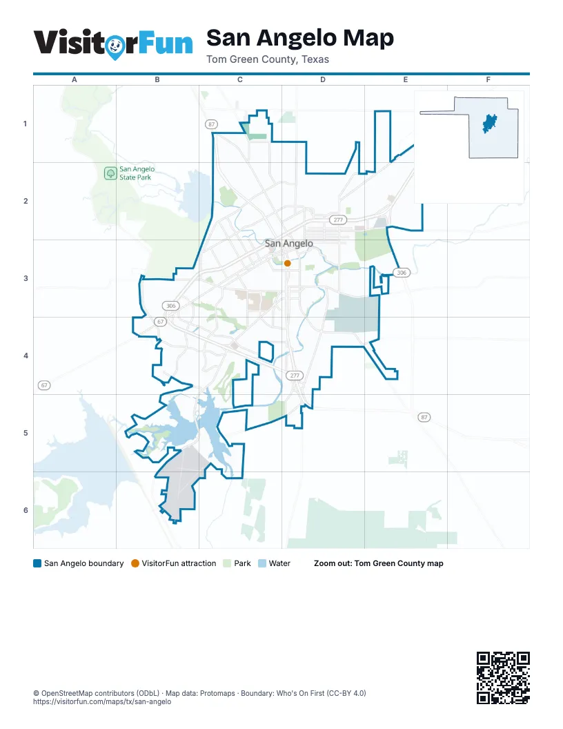
Street index of San Angelo
Each street on the sheet and the grid squares it crosses.
- South Bryant BoulevardD3, D4, D5
- West Houston Harte ExpresswayC2, D2, B3, C3, B4
- East Houston Harte ExpresswayD2, E2
- South Loop 306E2
- North Bryant BoulevardC1, C2, C3
- Sherwood WayB3, C3, B4
- West Beauregard AvenueC3, D3
- Armstrong StreetD1, D2
- North Main StreetD2, D3
- West 19th StreetC2
- South Koenigheim StreetD3
- East 19th StreetC2, D2
- South Abe StreetD3
- East Beauregard AvenueD3
- North Koenigheim StreetC3, D3
- North Abe StreetC3, D3
- US Highway 87 NorthC1
- South Main StreetD3
- West Loop 306B3, B4, C4
- Knickerbocker RoadC3, D3, C4, B5, C5
- West Houston Harte Frontage RoadB3, C3, B4
- North Chadbourne StreetC1, C2, D2, D3
- South Chadbourne StreetD3, D4
- South Jackson StreetC3, C4, D4
- Christoval RoadD3, D4
- US Highway 67 NorthE1, E2
- Southwest BoulevardB3, B4
- West Avenue NC3, D3
- Pulliam StreetD2, E2
- East Houston Harte Frontage RoadD2, E2
- North Bell StreetD2, D3
- Glenna StreetC2, C3
- South Johnson StreetC3, C4
- West Avenue LC3, D3
- Twin Mountain DriveB4, C4
- Paint Rock RoadD3, E3
- South Oakes StreetD3
- Arden RoadB3, C3
- South FM 2288B3, B4
- South Bell StreetD3
- Freeland AvenueC3
- East 7th StreetD2
- Dallas StreetC3
- La Follette StreetD2, E2
- East 6th StreetD2
- Caddo StreetC3
- West 29th StreetC2
- Edmund BoulevardC2
- Shiloh StreetC3
- Ellis StreetD2
- East Avenue LD3
- West 7th StreetC2, D2, C3
- Farm-to-Market Road 765D4, E4
- East 5th StreetD2
- West 6th StreetC2, D2, C3
- Loop 306 Frontage RoadE2
- Ben Ficklin RoadD3, D4, D5
- Sunset DriveB3, B4, C4
- Old Ballinger HighwayE1, D2, E2
- College Hills BoulevardC3, C4
- Southland BoulevardB4, C4
- Smith BoulevardE2
- Country Club RoadC5, D5
- North Bryant Boulevard Frontage RoadC1, C2
- West Harris AvenueC3, D3
- US 87 Frontage RoadD4, D5
- Grape Creek RoadC1, C2
- East 28th StreetC2, D2
- Kearney BoulevardD3, D4
- Preusser StreetD2, D3
- North Van Buren StreetC2, C3
- Lake DriveC1, C2
- Rio Concho DriveD3
- Foster RoadC4, C5
- Koberlin StreetD2
- Valleyview BoulevardB4, C4
- North Howard StreetC2, C3
- East 18th StreetC2, D2
- East Harris AvenueD3
- North Poe StreetD2, D3
- Spaulding StreetD2
- Lake View Heroes DriveC1, D1
- Travis StreetC1, C2
- Upton StreetD2
- Junius StreetC2, C3
- University AvenueC3
- Austin StreetC3
- North Jefferson StreetC2, C3
- Cox RoadC4, D4
- North Garfield StreetC3
- East 37th StreetC2, D2
- East 14th StreetC2, D2
- Pecos StreetC3
- South Van Buren StreetC3
- North Baze StreetD2, D3
- West Washington DriveC3, D3
- North Emerick StreetD2, D3
- East 29th StreetC2, D2
- Foster StreetC3, C4
- Grand Canal RoadD5
- Hughes StreetD2
- Culwell StreetD2
- South Jefferson StreetC3
- North Washington StreetC3
- South Washington StreetC3
- West Avenue QD3
- East Concho AvenueD3
- Currier StreetC3
- East Loop 306D4
- Link RoadD4
- North Johnson StreetC3
- Perimeter RoadD3, E3, D4, E4
- West Twohig AvenueC3, D3
- Guadalupe StreetC3
- South Concho DriveC5, C6
- North Oakes StreetC2, D2, D3
- North River DriveC2, C3
- San Antonio StreetC3
- Camper RoadB5
- South Irving StreetD3
- North Irving StreetC2, D2, D3
- Red Bluff RoadB4, B5
- Webster StreetC2, C3
- Martin Luther King DriveC2, D2, D3
- Sul Ross StreetC3, C4
- Pecan StreetC2, D2
- Farr StreetC2, D2, D3
- Forest Park AvenueC2, C3
- Blum StreetD1, D2
- East 50th StreetD1, E1
- West Avenue JC3, D3
- Rio Grande StreetC3
- West Concho AvenueC3, D3
- Bowie StreetC1, C2, D2
- Colorado AvenueC3
- Covington RoadE1
- Grandview DriveD2, B4, C4
- North Magdalen StreetC2, D2, D3
- North StreetC3
- Green Meadow DriveB4, C4
- East 22nd StreetC2, D2
- Live Oak StreetC3
- West Avenue MC3, D3
- Juanita AvenueC2, C3
- South Randolph StreetD3
- Ricks DriveD2, E2
- East 24th StreetC2, D2
- East 40th StreetC2, D2
- Westland AvenueC2, C3
- Briargrove LaneB4, C4
- Childress StreetC2, C3
- Ashford DriveB3
- North Harrison StreetC2, C3
- Woodlawn DriveC2, C3
- Pruitt DriveD1, D2
- Volney StreetC2, D2
- East 42nd StreetC1, D1
- Jackrabbit TrailD4
- Hunters Glen RoadB3, B4
- Coleman StreetC3
- Fishermans RoadB5
- East 21st StreetC2, D2
- Hangar RoadB5, B6
- East 23rd StreetC2, D2
- Vista del Arroyo DriveC4
- Clearview DriveB4, C4
- Lindenwood DriveC4
- Lindell AvenueC2, C3
- East 20th StreetC2, D2
- Hillside DriveB5
- Field StreetC2, C3
- Hatcher StreetC3
- Stone Canyon TrailB4, C4
- West Avenue KC3, D3
- Dena DriveC3
- East 25th StreetC2, D2
- South Country Club RoadC5, C6
- South Park StreetC3
- East 39th StreetC2, D2
- Veck StreetD2
- South David StreetC3, D3
- Marx StreetD2
- East 43rd StreetC1, D1
- Canberra Street EastD3, E3, E4
- Hassell StreetC3
- Paseo de Vaca StreetC3
- Beaty RoadC4, C5
- Ridgecrest LaneB4, C4
- South Concho Park DriveD3
- West Avenue DC3, D3
- Fort Lancaster AvenueD3, D4
- Parimeter RoadD3, D4
- Green Valley TrailB4
- Crockett StreetC1, C2
- Palo Duro DriveB4, C4
- Parkview DriveC4
- Millspaugh StreetC3
- North Emerson StreetD2, D3
- A & M AvenueC3, C4
- Chestnut StreetC3
- Fort Griffin AvenueD3, D4
- Shadyhill DriveB4
- North Monroe StreetC2, C3
- Meadow DriveC1
- East 17th StreetC2, D2
- West 14th StreetC2, C3
- Las Lomas DriveC5, C6
- North Archer StreetD2, D3
- Executive DriveC4
- Appaloosa TrailB3, B4
- North Bentwood DriveC4
- West River DriveC3, D3
- Melrose AvenueB3
- Sellers StreetD3
- South Madison StreetC3
- Beverly DriveC4
- Millbrook DriveB3, C3, C4
- Era StreetD3, E3
- Reary BoulevardB5, B6
- Waco StreetC3
- East 41st StreetC2, D2
- North Pope StreetD2, D3
- West Avenue IC3, D3
- Canyon Creek DriveB4, C4
- Douglas DriveC3
- East 47th StreetC1, D1
- Holcomb StreetD2
- Hill StreetD3
- South Monroe StreetC3
- Guthrie StreetC3
- Rock Brook DriveB4, C4
- Oaklawn StreetC1, C2
- Houston StreetC3
- Abilene StreetC3
- Alta Vista LaneB4, C4
- Fairview School RoadD4
- Forest TrailC3, C4
- South Oxford DriveC3
- South Harrison StreetC3
- East Highland BoulevardD3
- East Riverside AvenueD3, E3
- Oak Mountain TrailB4, C4
- Greenwood StreetC2
- Middle Concho DriveB5
- Briant StreetD2
- Ransom RoadC1, C2
- Old Eola RoadD4, E4
- Coke StreetD3
- Glenwood DriveC2, C3
- Wilson StreetC2
- La Salle DriveD3
- Hatchery RoadC1, C2
- East 26th StreetC2, D2
- Woodruff StreetD3
- Brown StreetC2
- Raney StreetC2, C3
- Stratford AvenueB3
- Classen BoulevardC2, C3
- McGill BoulevardE2
- North Cecil StreetD2, D3
- Walnut StreetC3
- Oak Grove BoulevardB4
- Avondale AvenueB3
- Silver Spur DriveB4
- West Avenue HC3, D3
- South A & M AvenueC3
- South Fillmore StreetC3
- West 17th StreetC2
- Pecan Valley LaneD4, D5
- Mercedes AvenueB3, C3
- Orient StreetD3
- North Bishop StreetC2, C3
- Amberton ParkwayB3
- Porter Henderson DriveE1, E2
- Blue Grama TrailB4
- Butler DriveC4, C5
- Cedar Hill DriveB4, C4
- Humble RoadC2
- Fairway DriveC4
- Gun Club RoadB5
- Rust StreetD3
- Alamo StreetC1, C2
- Walnut Hill DriveB4, C4
- East 13th StreetD2
- West 11th StreetC2, D2
- West Highland BoulevardC3, D3
- South Pierce StreetC3
- West 37th StreetC2
- East Avenue DD3
- ScherzD3, D4
- North Browning StreetD2, D3
- Kenwood DriveC3
- Oriole DriveC1
- Alexander StreetC3
- School House DriveB4
- North Campus BoulevardC3
- Wolf Creek DriveC4
- West 18th StreetC2
- West 16th StreetC2
- Club House LaneC4
Things to do on the San Angelo map
Places on the map
- Angelo State University
- Angelo West Branch Library
- Belaire Elementary School
- Bell Street Reservoir
- Belvedere Memorial Cemetery
- Bentwood Country Club Golf Course
- Bonham Elementary School
- Brentwood Park
- Calvary Cemetery
- Central High School
- Civic League Park
- Clayton Homes
- College Hills/Unidad Park
- College Park
- Concho Valley Electric Co-Op
- Fairmount Cemetery
- Goodfellow Air Force Base
- Lake Nasworthy
- Middle Concho Park
- North Concho River
- Quicksand Golf Course
- Rio Concho Park
- Riverside Hills Golf Club
- San Angelo City Park
- San Angelo Country Club
- San Angelo Fairgrounds
- San Angelo Landfil
- San Angelo Marketplace
- Shannon South Emergency Room
- Sherwood Oaks
- South Concho Park
- Southwest Plaza
- Spring Creek Park
- Stadium Park
- Sunset Mall
- Sunset Plaza
- Sunset Shopping Center
- Texas Bank Sports Complex
- The Shops at Sherwood
- Tom Green County Jail
© OpenStreetMap contributors, Open Database License, openstreetmap.org/copyright · Map data: Protomaps · Boundary: Who's On First (CC-BY 4.0); Quattroshapes (CC BY 2.0)















