

Texas map
Tom Green County map
About 120,103 people live here (Census Bureau, 2024 estimate). The sheet's index lists 300 streets; US 87 Frontage Road, March Road and US Highway 87 North cross the most grid squares. Things to do inside the boundary: San Angelo Visitor Center.
Open the map (PDF, US Letter)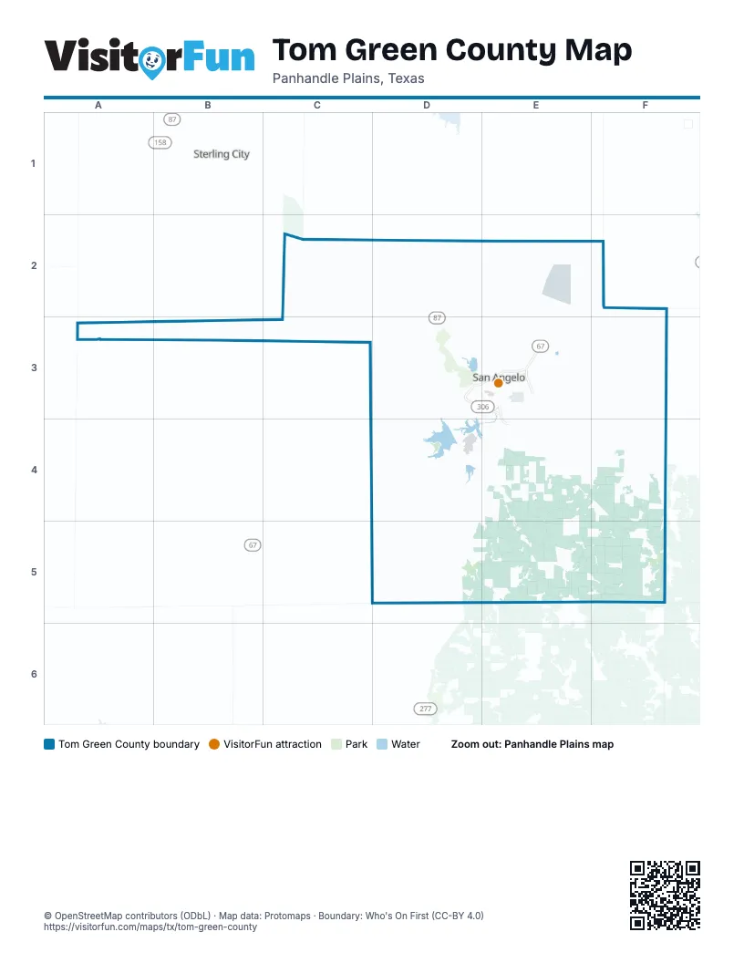
Maps inside Tom Green County
1 map inside, from the street map of Tom Green County down.
Street index of Tom Green County
Each street on the sheet and the grid squares it crosses.
- US Highway 87 SouthE4, F4
- South Bryant BoulevardE3, E4
- West Houston Harte ExpresswayD3, E3
- South Loop 306E3, E4
- East Houston Harte ExpresswayE3
- US Highway 87 NorthC2, D2, D3
- US Highway 67 NorthE2, F2, E3
- State Highway 208E2, E3
- US Highway 67 SouthD3, C4, D4
- North Bryant BoulevardD3, E3
- Sherwood WayD3, E3
- West Beauregard AvenueD3, E3
- Armstrong StreetE3
- North Main StreetE3
- West 19th StreetE3
- South Koenigheim StreetE3
- East 19th StreetE3
- South Abe StreetE3
- East Beauregard AvenueE3
- North Koenigheim StreetE3
- North Abe StreetE3
- South Main StreetE3
- Knickerbocker RoadD3, E3, D4
- Farm-to-Market Road 765E3, F3
- Farm to Market Road 2335D4
- Arden RoadC3, D3
- Toe Nail TrailD5, E5
- Tennyson RoadE2, E3
- North FM 2288D3
- West Loop 306D3, E3
- Farm to Market Road 2334E3, F3, E4
- West Houston Harte Frontage RoadD3
- North Chadbourne StreetD3, E3
- South Chadbourne StreetE3
- Farm to Market Road 1929F2, F3
- East FM 2105E3
- South Jackson StreetE3
- Christoval RoadE3
- Southwest BoulevardD3
- Paint Rock RoadE3
- West FM 2105D3, E3
- Pulliam StreetE3
- West Avenue ND3, E3
- East Houston Harte Frontage RoadE3
- South FM 2288D3
- North Bell StreetE3
- Main StreetC2, D2, D5
- Dallas StreetD2, D3, E3
- Glenna StreetD3
- South Johnson StreetE3
- West Avenue LE3
- Twin Mountain DriveD3
- South Oakes StreetE3
- South Bell StreetE3
- Freeland AvenueD3, E3
- East 7th StreetE3
- La Follette StreetE3
- East 6th StreetE3
- Caddo StreetE3
- West 29th StreetE3
- Edmund BoulevardD3, E3
- Shiloh StreetE3
- Ellis StreetE3
- East Avenue LE3
- West 7th StreetE3
- East 5th StreetE3
- West 6th StreetE3
- Loop 306 Frontage RoadE3
- Church StreetD5
- Farm to Market Road 1223E4, F4
- Susan Peak RoadE4, F4, F5
- Grape Creek RoadD2, D3, E3
- Old Sterling City HighwayC2, D2, D3
- US 87 Frontage RoadD2, D3, E3, E4
- Burma RoadD2, C3, D3
- West Grape Creek RoadD2
- Old Ballinger HighwayE3
- North Burma RoadC3, D3
- Ben Ficklin RoadE3, E4
- Sunset DriveD3, E3
- South Burma RoadD3
- Country Club RoadD4, E4
- College Hills BoulevardD3
- Southland BoulevardD3, E3
- Smith BoulevardE3
- North Bryant Boulevard Frontage RoadD3, E3
- West Harris AvenueD3, E3
- East 28th StreetE3
- Kearney BoulevardE3
- Preusser StreetE3
- North Van Buren StreetE3
- Lake DriveD3, E3
- Spring AvenueC2
- Rio Concho DriveE3
- Foster RoadE3, E4
- Loop 570E4
- Koberlin StreetE3
- Valleyview BoulevardD3, E3
- North Howard StreetD3, E3
- East 18th StreetE3
- East Harris AvenueE3
- North Poe StreetE3
- Austin StreetD2, E3
- Spaulding StreetE3
- Lake View Heroes DriveE3
- Travis StreetE3
- Upton StreetE3
- Sideview RoadD3
- Junius StreetD3, E3
- 8th StreetD2, D5
- West Carlsbad LoopD2
- University AvenueE3
- North Jefferson StreetE3
- Cox RoadE3
- North Garfield StreetD3, E3
- East 37th StreetE3
- East 14th StreetE3
- Pecos StreetE3
- South Van Buren StreetE3
- North Baze StreetE3
- West Washington DriveE3
- North Emerick StreetE3
- East 29th StreetE3
- Foster StreetE3
- Grand Canal RoadE4
- Hughes StreetE3
- Culwell StreetE3
- South Jefferson StreetE3
- North Washington StreetE3
- South Washington StreetE3
- West Avenue QE3
- Brown DriveD3
- Brodnax LaneE4
- East Concho AvenueE3
- Currier StreetE3
- Ranch Road 2034C2
- East Loop 306E3
- Link RoadE3
- North Johnson StreetE3
- Fort McKavett RoadE3, F4, F5
- Door Key RoadE4, E5
- March RoadD2, E2, D3, E3
- Hawk AvenueE3, E4
- Sutton RoadD2
- Mullins Crossing RoadF2, F3
- Gray RoadF3
- Robby Jones RoadE4
- Walling Pecan RoadE4
- Duff RoadD5
- Allen RoadD5
- City Farm RoadE3
- Debus RoadE3, E4
- Turner RoadC2, D2
- South York RoadF4
- South Crook RoadF4
- 5th RoadF3
- Twin Lakes LaneD4
- Guinn RoadD4, D5
- Ripple RoadE4
- North Klattenhoff RoadE2
- Gesch RoadF3
- Bledsoe RoadF3
- South Jameson RoadD3
- Fairview School RoadE3, E4
- South Englert RoadF3, F4
- North Walnut Grove RoadD2
- Schwartz RoadE4
- Duncan RoadD3, D4
- Helwig RoadF3
- Wilde RoadE3, E4
- Rocking Chair RoadF4, E5, F5
- Wood RoadE4
- Mikulik RoadE4
- Phinney RoadF3
- Glass RoadD2
- South Road 3F3
- North Red Creek RoadE2, E3
- Roberts RoadF4
- Mount RoadD2
- Blumentritt RoadE3
- Rust RoadE2, E3
- North Cross RoadF2
- Runion RoadE2, E3
- Marathon Oil Co RoadE4
- Streicher RoadE4, F4
- Hall LaneC2
- Wren RoadD2
- Jones RoadF4, E5
- Walnut GroveD2
- Powell LaneF3, F4
- Holik RoadE4, F4
- Bean RoadE3, E4
- Perimeter RoadE3
- Harriett RoadE3
- East Penny LaneE3, F3, E4
- Harper RoadD2
- Orient RoadE2
- East 50th StreetE3
- East Red Creek RoadE3
- East Arrington RoadF3
- Veribest Park RoadF3
- East Veribest RoadF3
- Green Oaks DriveD5
- East Jarratt RoadF3
- North Valley RoadE2, E3
- Spillway RoadD4
- Bill Pfluger RoadF5
- West Walnut Grove RoadD2
- Tweedy RoadD4
- Spring Creek LaneD4
- Switzer RoadF3
- East Ames RoadE3
- West Twohig AvenueE3
- Twin Buttes Marina Park RoadD3, D4
- Ballard RoadD2
- School House RoadF5
- Jim Barron RoadF5
- Willeke Pit RoadD3
- Guadalupe StreetD3, E3
- San Antonio StreetD2, D3, E3
- McDonald RoadD4
- Fisher StreetD3
- South Concho DriveD4, E4
- North Landers RoadE2
- Sanders RoadF4
- Dewolf RoadE5
- North Oakes StreetE3
- Camper RoadD4
- North Arrington RoadF3
- Treece RoadF3, F4
- Fuchs RoadE2, F2
- South Fairview School RoadE4
- East Klattenhoff RoadE2, F2
- East Douglas LoopF2, F3
- McMillan RoadF3
- North River DriveE3
- West Torres RoadD4
- South Allen LoopF4
- Coleman StreetD2, D3, E3
- Green RoadE4
- 1st RoadF3
- Mount Nebo RoadD2
- Neiman RoadF3
- South Irving StreetE3
- South Road 1F3
- Lee LaneF4
- Dove Creek Lane WestD4
- Sisco RoadC2
- Thompson RoadE2, E3
- Dove Creek Lane EastD4
- North Irving StreetE3
- Red Bluff RoadD3, D4
- Hohmann RoadE3
- Webster StreetD3, E3
- Martin Luther King DriveE3
- Sul Ross StreetD3, E3
- South Carlsbad Loop RoadD2
- Kotrla LaneF4
- Franco RoadD4
- Pecan StreetE3
- Farr StreetE3
- North Veribest RoadF3
- Pulliam Ranch RoadD3
- South Douglas LoopF3
- Schnieder RoadF2, F3
- Hidden View RoadE4
- Forest Park AvenueD3, E3
- Blum StreetE3
- Deer Run RoadD2
- Wright RoadF3, D4, E4
- Heinze RoadE2, F2
- Old Eola RoadE3
- West Avenue JE3
- South Ratliff RoadE4
- Swain RoadE2, E3
- Rio Grande StreetD3, E3
- West Concho AvenueE3
- Bowie StreetE3
- Colorado AvenueE3
- Covington RoadE3
- Duckworth RoadE3
- Grandview DriveD3, E3
- Post Oak RoadD2
- 3rd RoadF3
- North Magdalen StreetE3
- North StreetD3, E3
- Edinburgh RoadD3
- Green Meadow DriveD3
- Sierra TrailE2
- East 22nd StreetE3
- Live Oak StreetE3
- Bitner RoadE3
- West Douglas LoopF2, F3
- Krupola RoadE4
- West Avenue ME3
- Juanita AvenueD3, E3
- South Randolph StreetE3
- Deer Valley DriveD2
- East Carlsbad Loop RoadD2
- Sunrise LoopD4
Things to do on the Tom Green County map
Places on the map
- Affordable Super Storage
- Allen Hill
- Bentwood Country Club Golf Course
- Broome Air Force Auxiliary Airfield (Aban'd)
- Christoval High School
- Ducote Airpark
- Fairmount Cemetery
- Goodfellow Air Force Base
- Grape Creek High School
- Kenneth Brown Reservoir
- Lake Nasworthy
- Middle Concho Park
- North Concho River
- O C Fisher Lake
- Pugh Park
- Quicksand Golf Course
- Rio Concho Park
- Riverside Hills Golf Club
- Roadrunner Loop
- San Angelo
- San Angelo City Park
- San Angelo Country Club
- San Angelo Fairgrounds
- San Angelo Landfil
- San Angelo Marketplace
- San Angelo State Park
- Shannon South Emergency Room
- Sherwood Oaks
- Smetana Farms
- South Concho Park
- Southwest Plaza
- Spring Creek Park
- Stadium Park
- Sunset Mall
- Sunset Plaza
- Sunset Shopping Center
- Texas Bank Sports Complex
- The Shops at Sherwood
- Tom Green County Jail
- Twin Buttes Reservoir
Next to Tom Green County
- Sterling City
© OpenStreetMap contributors, Open Database License, openstreetmap.org/copyright · Map data: Protomaps · Boundary: Who's On First (CC-BY 4.0); Quattroshapes (CC BY 2.0)















