

Texas map
Santa Fe map
About 13,131 people live here (Census Bureau, 2024 estimate). The sheet's index lists 263 streets; Highway 6, 2nd Street and 4th Street cross the most grid squares. Also on it: Santa Fe High School, Rebel Field and Runge Park.
Open the map (PDF, US Letter)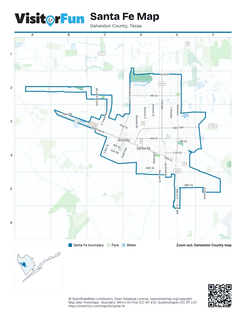
Street index of Santa Fe
Each street on the sheet and the grid squares it crosses.
- Cemetery RoadD1, D2, D3
- Oak LaneD1
- Algoa-Friendswood RoadA2
- Calvert LaneA2
- Cates RoadA2
- McKay RoadA2
- Murphy RoadA2
- Ps Ranch RoadB2
- Rymal RoadB2
- Smith RoadB2
- Jack Beaver RoadC2
- Tower RoadC2
- 2nd StreetD2, E2, C3, D3
- 4th StreetD2, E2, C3, D4
- Avenue QD2, D3, D4
- Avenue SD2, D3, D4
- Bethel CourtD2
- Carolyn LaneD2
- Christi LaneD2
- D Wagner LaneD2
- Everest Glen DriveD2
- Everest RoadD2
- Gibson LaneD2
- Harriett LaneD2, E2
- Jamie LaneD2
- Lago CircleD2
- Lago Circle NorthD2
- Lago CoveD2
- Lynn LaneD2
- Mount Vernon StreetD2
- Parrish RoadD2
- Penny LaneD2
- Ponderosa PlaceD2, E2
- Shouse RoadD2, D3
- Sunset CircleD2, E2
- Wagner CourtD2, E2
- Washington StreetD2
- Avenue JE2, E3, E4
- Avenue LE2, E3, E4, E5
- Core Meadows DriveE2
- Donna CourtE2
- Dune Run DriveE2
- Faught ParkwayE2
- FM 646E2, E3, E4
- Freeboard DriveE2
- Garret CourtE2
- Jumeirah LaneE2
- Marion LaneE2
- Milan CircleE2
- Poston RoadE2
- Santo Park RoadE2
- Sea Nettles DriveE2
- Seagrass Knoll LaneE2
- Starboard Reach DriveE2
- Sun Coral DriveE2
- Thaman DriveE2
- Trista CourtE2
- Young CircleE2
- Avenue BB3, F5
- Avenue DB3
- East State Highway 6B3
- Highway 6B3, C3, C4, D4, E4
- Holloway RoadB3
- Magnolia StreetB3
- Park RoadB3
- Satsuma StreetB3
- Webb RoadB3
- Webb StreetB3
- 1st StreetC3, D3
- Beriton StreetC3, C4, D4
- Downey StreetC3, C4
- Elm RoadC3, D3
- Elm StreetC3, C4
- Garden StreetC3, D3
- Maple AvenueC3
- Maple StreetC3
- Morning Glory DriveC3
- North Elm RoadC3
- North Morning Glory DriveC3
- Pine StreetC3, D3
- Santa Fe StreetC3
- Scott AvenueC3, D3, C4
- Shady DriveC3
- Sias LaneC3
- South Tower RoadC3
- Terry StreetC3, D3, C4
- Tower EstatesC3
- Walnut StreetC3
- Williams RoadC3
- Williams StreetC3
- 2nd Street WestD3
- 3rd StreetD3, E3, D4
- 4th 1/2 StreetD3, E3, F3
- 6th StreetD3, D4, E4
- Alles House RoadD3
- Anna CourtD3
- Anne LaneD3
- BluebonnetD3
- Bolin RoadD3
- Broken ArrowD3
- Bunde RoadD3
- Cardin LaneD3
- Cark AvenueD3, C4, D4
- DaisyD3
- Elizabeth DriveD3
- FM 1764D3, E3, F3, D4
- Frost StreetD3, D4
- Jackson StreetD3, C4, D4
- Jan LaneD3
- North Jackson StreetD3
- Oleo LaneD3
- Pecan Circle SouthD3
- Pecan Trails DriveD3
- Peck AvenueD3, C4, D4
- Poplar StreetD3
- Rene CircleD3
- Ryan RoadD3
- Schattel RoadD3
- SunflowerD3
- Wade StreetD3, D4
- Walker StreetD3
- Winston DriveD3
- Allen DriveE3
- Avenue EE3, E4
- Avenue East 1/2E3
- Avenue FE3, E4, E5
- Avenue G-1/2E3, E4, E5
- Avenue J 1/2E3
- Avenue KE3, E4
- Avenue K 1/2E3
- Bellano Bay DriveE3
- Bruce Hall RoadE3
- Campbell Cove LaneE3
- Daniel Shores DriveE3
- Derrick StreetE3, F3
- Giles RoadE3, F3
- Giusti LaneE3
- Hammond LaneE3
- Henkel LaneE3
- Lamar LaneE3
- Lierna DriveE3
- Longmire StreetE3, F3
- McGregor StreetE3
- Robert LaneE3
- Rush RoadE3
- Seneca Lake DriveE3
- Sherril Yinn Sunset DriveE3
- Shirley LaneE3, F3
- Wadley Bay DriveE3
- Winter Sand DriveE3
- Dalvay Beach DriveF3
- Eagle Nook DriveF3
- Emerald Mallard DriveF3
- Islawind WayF3
- Shellbark WayF3
- Stonewater Cove DriveF3
- 5th StreetC4, D4
- 7th StreetC4, D4, E4
- 8th StreetC4, D4
- Ash RoadC4, D4
- Birch StreetC4
- Cedar DriveC4
- Cedar StreetC4, D4
- Edgemore StreetC4
- Fir RoadC4
- Highland RoadC4
- Jensen StreetC4
- Park StreetC4, D4
- South Elm StreetC4
- Tallow RoadC4
- West 6th StreetC4, D4
- 18th StreetD4, E4
- 19th StreetD4, E4
- 24th StreetD4, E4
- 7th Street WestD4
- 9th StreetD4, E4
- Avenue PD4, D5
- Avenue Q 1/2D4
- Avenue RD4, D5
- Avenue TD4, D5
- Beaver RoadD4
- Bob White DriveD4
- Bolton AvenueD4
- Castle DriveD4
- Cherry LaneD4
- Cherry StreetD4
- Colton LaneD4
- Davis Hall RoadD4
- Dover AvenueD4
- East Bellaire StreetD4, D5
- Farm-to-Market Road 1764D4
- Henley StreetD4
- Julia LaneD4
- Kaylee LaneD4
- Kent LaneD4
- Mandy LaneD4
- Middleham LaneD4
- Preston DriveD4
- Raford LaneD4
- Rochester CourtD4
- Sesame StreetD4
- Temple CircleD4
- Treepoint LaneD4
- Twin Drive EastD4
- Twin West DriveD4
- Wagner WayD4
- Warpath AvenueD4
- West Bellaire StreetD4, D5
- Windsor CourtD4
- 10th StreetE4
- 11th StreetE4
- 12th StreetE4
- 13th StreetE4
- 14th StreetE4
- 15th StreetE4
- 16th StreetE4
- 17th StreetE4
- 20th StreetE4
- 21st StreetE4
- 22nd StreetE4
- 23rd StreetE4
- 25th StreetE4
- 7 1/2 StreetE4
- A Bar DriveE4
- Anders LaneE4
- Avenue HE4
- Avenue IE4
- Avenue ME4
- Avenue M 1/2E4, E5
- Avenue N 1/2E4
- Avenue NorthE4
- Avenue OE4
- B Bar DriveE4
- Britian StreetE4
- Burditt StreetE4
- C Bar CircleE4
- C Bar DriveE4
- Chisholm TrailE4
- D Bar DriveE4
- E Bar DriveE4
- Eaton DriveE4
- F Bar DriveE4
- L StreetE4
- Langford StreetE4
- Main StreetE4
- Mulberry StreetE4
- Murello DriveE4
- Old Spanish TrailE4
- Oregon TrailE4
- Pecan Grove StreetE4
- Taquard LandingE4
- South Bellaire StreetD5
- 28th StreetE5, F5
- 29th StreetE5
- 32nd StreetE5
- 645 Street SouthE5
- 646 Street SouthE5
- Avenue GE5
- 27th StreetF5
- Avenue AF5
- North Morningview StreetF5
- South Morningview StreetF5
- Tibaldo LaneF5
Places on the map
- Alamo Gym
- Aldersgate United Methodist Church
- Amegy Bank
- Arcadia First Baptist Church
- AutoZone
- C & K Painting
- Chambers TV Service
- Chicken Express
- Dollar General
- El Valle Cafe
- Elizabeth Cowen Elementary School
- First Baptist Church
- Fritz Barnett Intermediate School
- Galveston County Juvenile Justice Alternative Education Program
- Galveston County Sheriff's Office
- Garage
- Indian Stadium
- Jack in the Box
- Little Caesars
- Lorenzo’sPizza
- McDonald's
- Old Arcadia Cemetery
- Pee Wees Heliport
- R J Wollam Elementary School
- Rebel Field
- Runge Park
- Saint Johns Lutheran Church
- Santa Fe Baptist Church
- Santa Fe Christian Church
- Santa Fe Elementary School
- Santa Fe Fire / Rescue Department
- Santa Fe Fire & Rescue Station #1
- Santa Fe Girls Softball
- Santa Fe High School
- Santa Fe Junior High School
- Santa Fe Police Department
- Shipley Do-Nuts
- Texas First Bank
- United States Postal Service
© OpenStreetMap contributors, Open Database License, openstreetmap.org/copyright · Map data: Protomaps · Boundary: Who's On First (CC-BY 4.0); Quattroshapes (CC BY 2.0)















