

Texas map
Terrell map
About 22,977 people live here (Census Bureau, 2024 estimate). The sheet's index lists 300 streets; State Highway 34 South, Airport Road and Griffith Avenue cross the most grid squares. Also on it: Terrell Municipal Airport, Crossroads at Terrell and Terrell State Hospital.
Open the map (PDF, US Letter)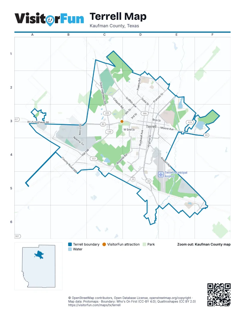
Street index of Terrell
Each street on the sheet and the grid squares it crosses.
- Ronald Reagan Memorial HighwayE5
- State Highway 34 SouthD3, D4, D5, D6, E6
- West Moore AvenueB3, C3, D3
- South Virginia StreetD3, D4
- State Highway 34 NorthE2, D3, E3
- FM 148C3, B4, C4
- State Highway 205C1, C2, C3
- East Moore AvenueD3, E3
- West US Highway 80A3, B3
- Airport RoadD4, E4, E5, F5
- North Virginia StreetD2, D3
- East Interstate 20D5
- North Rockwall AvenueD2, D3
- West State StreetD2, D3
- Poetry RoadD2
- Wilson RoadF5, F6
- North FM 148B4
- Griffith AvenueC1, C2, D2, D3
- Colquitt RoadC2, C3, D3
- Spur 557 Frontage RoadB4, C4
- North Frances StreetD2, E2, D3
- South Rockwall AvenueD3, D4
- Rosehill RoadC4, D4
- 9th StreetD2, D3
- Frontage RoadC4, D5
- Town North DriveD2, E2
- South Adelaide StreetD3, D4
- FM 2578D4, D5
- Windsor AvenueD4, D5
- East High StreetD3, E3
- Industrial BoulevardD4
- College Mound RoadD3, E3, E4
- East State StreetD3, E3
- Bradshaw StreetD3
- I 20 East Access RoadF5, F6
- Bethlehem StreetD3, D4
- West Interstate 20B4, C4
- East Temple StreetD3, D4
- West High StreetD3
- Lovers LaneC2
- Las Lomas ParkwayB3, B4
- East Alamo StreetD3
- West University StreetD4
- Dellis StreetE3
- Gardner StreetD3, E3
- West Alamo StreetD3
- County Road 177E2
- Mayfield StreetE3, D4
- East University StreetD4
- Apache TrailB3, B4, C4
- County Road 305A4, B4, B5
- Tanger DriveD5
- South Medora StreetD3, D4
- Crossroads ParkwayB4
- West End StreetC3, D3
- Mineral Wells StreetD3, C4, D4
- East Brin StreetD3, E3
- South Frances StreetD3, D4
- South Catherine StreetD3, D4
- North Blanche StreetD3, E3
- American WayB4
- Kings Creek DriveE5
- North Catherine StreetD2, D3
- San Jacinto StreetE2, D3, E3
- Elm DriveD2, D3
- British Flying School BoulevardD4, D5, E5
- East College StreetD3, E3
- Heather Lane CircleC4
- Crenshaw StreetD4
- South Delphine StreetD3, D4
- Meadowcrest DriveE2
- Metro DriveB3, B4
- South Park StreetD3, D4
- 3rd StreetD3
- East Nash StreetD3, E3
- 1st StreetD3
- Pacific AvenueD3
- Poinsetta CircleD2
- Main StreetD3
- Independence ParkwayB4
- Creekside DriveD2, E2
- Johnson StreetD3
- Trailview DriveD2, E2
- Davidson DriveD2
- Lawrence StreetD3
- North Park AvenueD3
- North Adelaide StreetD3
- South Hattie StreetD3, D4
- West Grove StreetD3
- West Nash StreetD3
- Williams StreetC3
- Woodlands BoulevardC4, D4
- Iron Horse DriveA3, B3
- Temtex BoulevardB3
- 4th StreetD3
- West Newton StreetD3
- Saint Luke StreetD4
- Frazier StreetD3, D4
- East Grove StreetD3, E3
- Tiffany CircleC4
- Leighton DriveC2, D2
- Laurel Trail NorthD2
- Lions Club LaneC3, D3
- New Hope StreetD4
- Walnut StreetD2
- Lexington DriveC2, D2
- North Island DriveD2, E2
- Warren AvenueD3
- Grace LaneD2, D3
- Beverly DriveD2, D3
- Charles LaneC2, D2
- West College StreetD3
- West Rochester StreetD3
- East McCoulskey StreetD2, E3
- Rose StreetE2, E3
- Brushy Creek LaneD2
- Redwood LaneD2
- Silent Wings BoulevardD4, E4
- North Morris StreetD3
- Talty RoadC3
- Daniels StreetD3, D4
- Gold Meadow DriveE5, E6
- Fairmeade DriveC4, D4
- Roosevelt AvenueD4
- Meridith DriveD2
- Stallings StreetD3, E3, E4
- Rash LaneC2, D2
- Greenwood StreetD3, E3
- Thomas StreetE3, E4
- Boone StreetD3
- Metrocrest WayB3
- West Brin StreetD3
- Laurel TrailD2
- Campbell StreetE3, E4
- County Road 138F6
- Frank StreetD3
- Goss StreetD2
- Hamilton DriveD4
- Rock Creek LaneD2, E2
- South Ann StreetD3
- Knoll Pines DriveD4
- Mount Olive StreetD4
- Still Glen DriveC4, D4
- Business CircleC3
- Brookhollow DriveC2, D2
- Tower CircleD3
- Houston StreetD3
- Eulalia DriveD2
- Jerry DriveE2, D3, E3
- Mira PlaceD5
- West Sparks StreetD3
- Collins DriveC2, D2
- Washington StreetD3
- Yosemite LaneD2
- Hackberry StreetD2, D3
- Roberts AvenueD3
- Gant StreetD2, D3
- Westgate DriveD2
- Ruby StreetD4
- Estate LaneE5, E6
- Westvue StreetD2
- North Ann StreetD3
- Shady Creek LaneD2
- Baker StreetD4
- 6th StreetD3
- 7th StreetD3
- 8th StreetD3
- Wall StreetD2
- Pin Oak DriveE5
- Laroe StreetD3, E3
- North Delphine StreetD3
- West Jackson StreetD3
- Allen StreetD3
- West Cottage StreetD3
- 5th StreetD3
- Eastgate DriveD2
- Wanda StreetD2
- Willow Creek LaneD2
- Runnells StreetD4, E4
- West I-20 Frontage RoadC4
- Bowser CircleD3
- Lane StreetC3, D3
- Meadowview CourtD5
- Timber CourtC3
- West Damon StreetD2, D3
- Circle DriveD2
- Spring Creek LaneD2
- Birdsong LaneC2, D2
- Market Center DriveB4
- Medical DriveB4
- Lee AvenueD3
- Westway DriveC3, D3
- Mellon StreetC3
- Ridgecrest DriveD2, E2
- Chappell StreetE3, E4
- James StreetD3
- North Burch StreetE3
- Sandlewood DriveE2
- County Road 304C4, C5
- Linda DriveD2, D3
- Gordon DriveD2, D3, E3
- Jackson DriveD4
- County Road 301D5
- Henderson StreetD4, E4
- Timberside DriveE5
- Clear Creek LaneD2, E2
- West Heath StreetD3
- Bennett StreetE4
- North HattieD3
- 2nd StreetD3
- Harrell StreetE4
- Rellia DriveC2, D2
- East Wheeler StreetD4
- West McCoulskey StreetD2
- East Dallas StreetD3
- East Broad StreetD3
- East Cottage StreetD3
- East Newton StreetD3
- Ruby CourtD4
- East Rochester StreetD3
- Lydia StreetE3
- Sue LaneE3
- Sage StreetD3
- Skyline DriveE4
- Myers StreetD4
- Forrest Creek LaneD2
- Willowbrook DriveD2, E2
- Dixon StreetE3
- Lamar StreetE3
- Stonegate DriveE2
- Betty DriveD2
- Lincoln LaneD4
- Tyler StreetE3
- Harrisee StreetE2
- Athens StreetE3
- Gilbert StreetD4
- West Myers StreetD4
- Vine StreetE4
- Northridge DriveD2, E2
- North Rockwall StreetD2
- Hawkins StreetC4
- Brookwood DriveE2
- Hardin StreetD2
- Pebble Creek LaneD2
- Pecan StreetD2, D3
- Crockett StreetD3, E3
- Southgate DriveD2, E2
- Live Oak LaneE2
- 11th StreetD3
- Wood StreetC4
- Hammond StreetD4
- Saint James StreetD4
- Kennedy DriveD4
- Polk StreetD4
- Glenda StreetD2
- Melody LaneE2
- Green StreetE3
- Maple DriveD2
- Rustic View DriveD4
- Riley StreetD4
- Oak DriveD2
- Tejas DriveC4
- Estess DriveD5
- Boston StreetC4
- Oak Post DriveD2
- Stoney Creek LaneD2
- Griffith CourtD2, D3
- Carl Lee CircleC2
- Cartwright StreetD3
- Champion RoadB4
- Ross StreetD2
- Oak StreetD3
- 10th StreetD3
- Howard StreetD3
- Bridge StreetD3
- Robert StreetD3
- Freeman StreetC2, C3
- Pecos StreetE3
- East Crescent StreetD4
- Brookline DriveD4
- Ninth StreetD2
- Hood StreetD4
- Jamison CourtB4
- Stonebriar WayD2, C3, D3
- Walker WayB4
- Nathaniel DriveD2
- Canton StreetE3
- Stanley F Tanger BoulevardD5
- Eason StreetD3
- Elizabeth StreetD2
- Wade StreetD3
- Artesia StreetE3
- Burnett StreetD3
- Haynes CircleC2
- Primrose StreetE2, E3
- Scott StreetD3
- June StreetE2
- Denali CourtD2
- Destiny CourtD4
- Olivia DriveB4
Places on the map
- Academy Sports + Outdoors
- American National Bank of Texas
- Applebee's
- Arlie E White Memorial Park
- Arlie White Memorial Basketball Court
- Baymont
- Ben Gill Baseball Fields
- Ben Gill Lake
- Ben Gill Park
- Bentley Hardware & Lumber
- Big Lots
- Breezy Hill
- Breezy Hill Park
- Breezy Hill Walking Path
- British Flying School Boulevard
- Brookshire's
- Buc-ee's
- Burke's Outlet
- Carmona's
- Chick-fil-A
- Crossroads at Terrell
- Doris Johnson Library
- J W Long Elementary School
- Lions Club Park
- New Oakwood Cemetery
- Oakland Cemetery
- Oakwood Cemetery
- Old Terrell City Lake
- QuikTrip
- Terrell Crossing
- Terrell High School
- Terrell Memorial Stadium
- Terrell Municipal Airport
- Terrell State Hospital
- The Shops at Terrell
- The Storage Place - Lockbox
- Walmart Supercenter
- Wildwood Cemetery
© OpenStreetMap contributors, Open Database License, openstreetmap.org/copyright · Map data: Protomaps · Boundary: Who's On First (CC-BY 4.0); Quattroshapes (CC BY 2.0)















