

Texas map
Tyler map
About 112,219 people live here (Census Bureau, 2024 estimate). The sheet's index lists 300 streets; South Broadway Avenue, US Highway 271 and South Bonner Avenue cross the most grid squares. Things to do inside the boundary: Caldwell Zoo and Tyler Rose Museum.
Open the map (PDF, US Letter)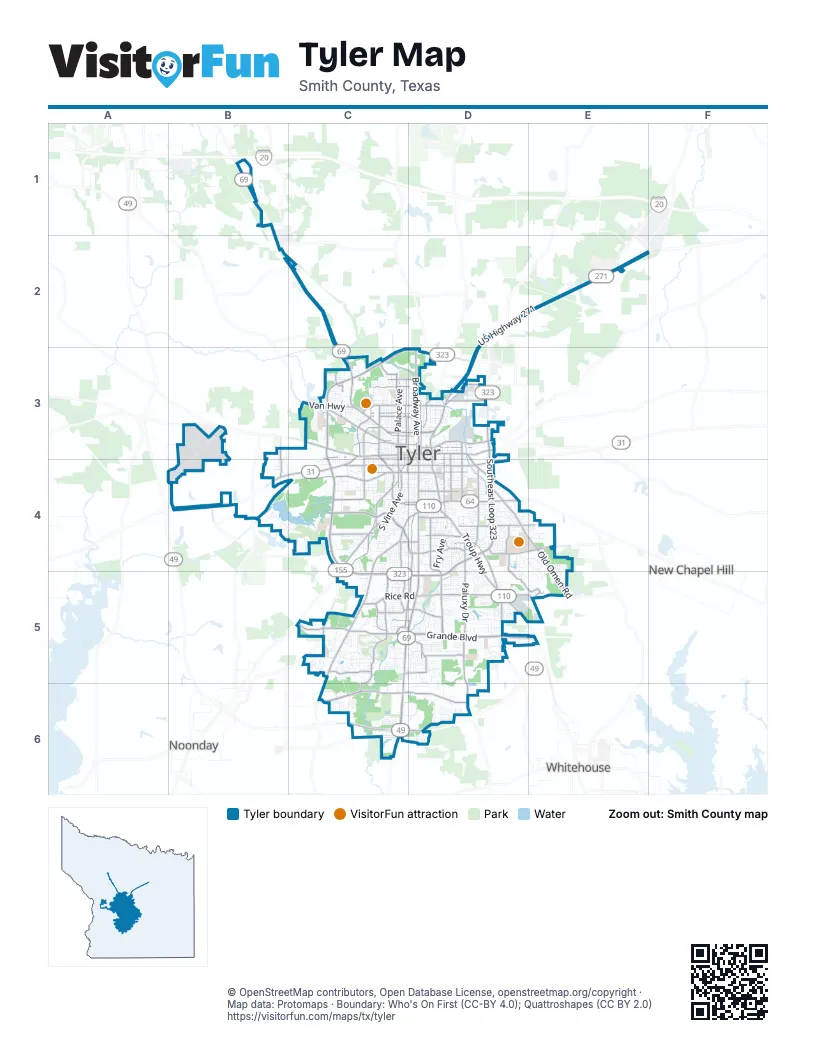
Street index of Tyler
Each street on the sheet and the grid squares it crosses.
- South Broadway AvenueD3, D4, C5, D5, C6
- US Highway 271D2, E2, F2, D3
- South Southwest Loop 323C3, C4
- West Northwest Loop 323C3, D3
- South Southeast Loop 323D3, D4
- Troup HighwayD4, D5
- East Southeast Loop 323D4, D5
- West Southwest Loop 323C4, C5, D5
- State Highway 31 WestB4
- West Gentry ParkwayC3, D3
- North Broadway AvenueD3
- East Fifth StreetD4
- North Northwest Loop 323C3
- US Highway 69 NorthC2
- South Vine AvenueC3, C4
- East Gentry ParkwayD3
- Chandler HighwayC3, B4, C4
- West Erwin StreetC3, D3
- East Front StreetD4
- South Glenwood BoulevardC3, C4
- West Front StreetC4, D4
- Toll 49C6, D6
- Frankston HighwayC4
- South Beckham AvenueD3, D4
- Mineola HighwayC2, C3
- North Glenwood BoulevardC3
- North Northeast Loop 323D2, D3
- East Northeast Loop 323D3
- West Bow StreetC3, D3
- State Highway 64 WestC3
- North Beckham AvenueD3
- East Fourth StreetD4
- West Fourth StreetC4, D4
- West Glenwood BoulevardC4
- West Fifth StreetC4, D4
- State Highway 155 SouthC4
- East 5th StreetD4
- State Highway 155 NorthE2
- East Grande BoulevardC5, D5, E5
- Paluxy DriveD4, D5, D6
- Earl Campbell ParkwayC4
- West Grande BoulevardC5
- Shiloh RoadD5, E5
- Old Jacksonville HighwayC5
- New Copeland RoadD5
- Old Jacksonville RoadC4, D4, C5
- Sunnybrook DriveC4, D4
- East Erwin StreetD3
- North Palace AvenueC3
- Old Henderson HighwayD3, D4
- University BoulevardD4, E4
- West Martin Luther King Junior BoulevardC3, D3
- Rice RoadC5, D5
- Van HighwayC3
- South Palace AvenueC3, C4
- Church AvenueD3
- East Martin Luther King Jr BoulevardD3
- Farm-to-Market Road 2493C5
- West Ferguson StreetC3, D3
- East Ferguson StreetD3
- North Bonner AvenueC3, D3
- North Center AvenueD3
- West Amherst StreetD4
- Old Omen RoadD4, E4, E5
- West Cumberland RoadC6
- Old Bullard RoadD4, C5, D5
- Hollytree DriveC5, C6
- Golden RoadD4
- Bellwood RoadC4
- McDonald RoadD4, E4
- Border AvenueC3
- Cumberland RoadC6, D6
- Garden Valley RoadC3
- Old Noonday RoadC4, C5
- Rieck RoadC5, D5
- West Elm StreetC3, D3
- Lazy Creek DriveD4, D5, E5
- South Fleishel AvenueD3, D4
- Copeland RoadD4, D5
- West Oakwood StreetC3, D3
- Noonday RoadC4
- East Commerce StreetD3
- Old Troup HighwayD4, D5
- North Parkdale DriveC3
- Rhones Quarter RoadD5
- North Spring AvenueD3
- East Houston StreetD4
- East Lake StreetD4
- West Houston StreetC4, D4
- South Baxter AvenueD3, D4
- Walton RoadC4
- Dueling OaksC5
- Cambridge RoadC5, D5
- South Lyons AvenueC3, C4
- East Line StreetD3
- Duncan StreetD3
- Forest AvenueC3
- West Harmony StreetC3, D3
- West Vance StreetC3, D3
- Jeff Davis DriveD5
- East Dulse StreetD4
- West 29th StreetC3, D3
- Eisenhower DriveB3, B4
- Palmer AvenueD3, D4
- Plantation DriveC5
- Old Grande BoulevardC5, D5
- Brookside DriveC4, C5
- North Grand AvenueC3
- Charlotte DriveC3
- Robert E Lee DriveC5, D5
- East Amherst StreetD4
- Robertson RoadC4
- Patriot DriveD4
- West 32nd StreetC3, D3
- Crow RoadC5
- De Charles StreetD4
- County Road 376D3
- Old Gladewater HighwayD2, E2, D3
- Kinsey DriveC5
- Richmond RoadC5
- Old Bascom RoadE5
- Texas College RoadC3
- Fair LaneC4, D4
- Chimney Rock DriveC5, D5
- South Bonner AvenueC3, D3, C4, D4
- Spur 364B4, C4
- Dennis DriveD4
- Briarcove DriveC5
- North College AvenueD3
- South Palmer AvenueD4
- West 34th StreetC3
- McMurrey DriveD3
- Silvercreek DriveC3
- Legacy BendC6
- Southwood DriveE5
- Montgomery GardensD3
- South Donnybrook AvenueD4
- Centennial ParkwayC6, D6
- South Robertson AvenueC4
- Pollard DriveD4, D5
- North Bois D'Arc AvenueD3
- North Confederate AvenueC3
- Three Lakes ParkwayC5
- Donnybrook AvenueD4, D5
- South College AvenueD3, D4
- Cherryhill DriveC5, C6
- North Ross AvenueC3
- North Englewood AvenueC3
- Skyway BoulevardB3
- West 2nd StreetC4, D4
- South Chilton AvenueD4
- Stonegate BoulevardD5
- Fry AvenueD4, D5
- Blue Mountain BoulevardC6
- Moore AvenueC3
- Kennedy AvenueC4
- Spring Creek DriveC5
- Cameron AvenueD4
- Mockingbird LaneC4, D4
- Peach AvenueC3, C4
- North Tenneha AvenueC3
- West Shaw StreetC4
- East Locust StreetD3
- North Gaston AvenueC3
- West 6th StreetC4, D4
- Oak Hill BoulevardC5
- Hollytree CircleC5
- Graemont BoulevardD5
- Roy RoadD5
- Barbara StreetD4
- Old Glory ParkwayD4, E4
- Cambridge BendD5
- Cloverdale DriveC4, C5
- East Oakwood StreetD3
- Woods BoulevardD4, E4, E5
- Shelley DriveC4, D4, D5
- Nimitz StreetB3, D5
- Pleasant Retreat RoadA4, B4
- West Nutbush StreetC3, D3
- Woodland Hills DriveC4, D4
- South Englewood AvenueC3, C4
- South Fannin AvenueD3, D4
- East Elm StreetD3
- Woodlands DriveC5
- East Earle StreetD4
- Mahon AvenueD3, D4
- North Fannin AvenueD3
- Bennett AvenueC4
- Wilder WayD6
- Birdwell DriveD4, D5
- Gleneagles DriveC5
- Hogan DriveC4
- West Mims StreetC3, D3
- Magnolia DriveD4
- Whiteside RoadC4
- Cascades BoulevardB4, C4
- North Carlyle AvenueD3
- South Sneed StreetD4
- West 1st StreetC4, D4
- Wilma StreetD4
- West Barrett StreetC3, D3
- Kensington DriveD5
- South Wall AvenueD4
- Bellwood Lake DriveB4, C4
- Negem RoadA4, B4
- Sutherland DriveD5
- Pine Crest DriveD4
- Claude StreetC3
- South Boldt AvenueD4
- Cascades Shoreline DriveB4, C4
- Lindsey LaneC4, D4
- Shaw StreetC4, D4
- Hillsboro StreetD3
- Jan AvenueD4
- Tipton AvenueD4
- Grand AvenueC3
- West Cochran StreetC3, D3
- Circle DriveD4, E4, D5
- Dublin DriveC6
- North Hill AvenueC3
- Augusta AvenueC4
- Patton LaneB3, B4
- West Queen StreetC3, D3
- East 8th StreetD4
- South Clayton AvenueD3, D4
- Dinah LaneD4
- West Dobbs StreetC4, D4
- Cherokee TrailD6
- Chisholm TrailD6
- Easy StreetD4, D5
- West 24th StreetC3, D3
- Belmont DriveD4
- East Dawson StreetD4
- South Porter AvenueD4
- Coventry RoadD6
- East Vance StreetD3
- Quail Creek DriveD5
- Crosslake BoulevardC5
- Silverwood DriveC4, C5
- Marsh Farm RoadC6, D6
- Keaton AvenueD4
- Old Hickory RoadD6
- West 5th StreetC4
- Loblolly LaneC4
- Aberdeen DriveD5
- Brighton Creek CircleE4, E5
- Pinkerton DriveD4
- East Nutbush StreetD3
- Trenton DriveC5
- Holly Creek DriveC5
- Chad DriveD5
- Woodbine BoulevardD4
- Edinburgh DriveD5
- East Lawrence StreetD4
- South Bois D'Arc AvenueD3, D4
- West 3rd StreetC4, D4
- Neighbors RoadC6
- Briarwood RoadC4
- Crosswater AvenueC5
- Rusk StreetC4, D4
- Bain PlaceD4
- Winona AvenueD3
- Pam DriveD5
- Pinehurst StreetC5
- Belvedere BoulevardC3
- North Glass AvenueC3
- Baldwin DriveC3
- West 7th StreetC4, D4
- North Lyndon AvenueD3
- Scott AvenueC3, C4
- South Confederate AvenueC3, C4
- Shenandoah DriveD4
- Belmead LaneD4, D5
- Kidd DriveD5
- County Road 219D4, E4
- West Heritage DriveC5
- Pine StreetC4
- Clubview DriveD4
- Pounds AvenueD4
- Wilson StreetC3, D3
- Elkton TrailC5
- Royal Oak DriveC5
- Adam Henry RoadE4
- Ashmore LaneC5
- West Connally StreetC4
- Lexington DriveD4, E4
- Carriage DriveC5
- Barclay DriveC5
- Sampson DriveD4
- Stonegate Valley DriveD5
- Idel StreetD4
- Shepherd LaneD4
- Devine StreetD4
- Chapel QuartersE4
- Chilton AvenueC4, D4
- Jeb Stuart DriveD5
- Gish LaneD4
- Industrial AvenueD3
- Guinn Farms RoadD5
- Red Raider DriveD5
Things to do on the Tyler map
Places on the map
- All Saints Episcopal School
- Azalea Residential Historic District
- Bellwood Lake
- BGC - Brookshire Grocery Company - Distribution Center - Tyler, TX
- Boulter Middle School
- Broadway Crossing
- Broadway Square
- Broadway Square Mall
- Caldwell Zoo
- CampV
- Centene
- CHRISTUS Mother Frances Hospital - Tyler
- Corporate Green Office Park
- Cumberland Academy High School
- Cumberland Lake
- Early College High School
- Faulkner Park
- French Quarter Shopping Center
- Fun Forest Park
- Golden Road Park
- Grace Community School
- Green Acres Baptist Church
- Hollytree Country Club
- Hospitality Health ER
- Lake Lee
- Noble E. Young Park
- Rose Rudman Park
- Skyway Boulevard
- Smith County Juvenile Services
- South Spring Baptist Church
- Southside Park
- The Cascades Golf Club
- The Village at Cumberland Park
- TJC Disc Golf Course
- TRANE Distribution
- Tyler High School
- Tyler Legacy High School
- West Mud Creek Lake
- Willow Brook Country Club
- Woldert Park
Next to Tyler
- New Chapel Hill
- Noonday
- Whitehouse
© OpenStreetMap contributors, Open Database License, openstreetmap.org/copyright · Map data: Protomaps · Boundary: Who's On First (CC-BY 4.0); Quattroshapes (CC BY 2.0)















