

Texas map
Victoria map
About 66,020 people live here (Census Bureau, 2024 estimate). The sheet's index lists 300 streets; Northeast Zac Lentz Parkway, US Highway 59 North and North Navarro Street cross the most grid squares. Things to do inside the boundary: Discover Victoria Visitor Center and Victoria Mall.
Open the map (PDF, US Letter)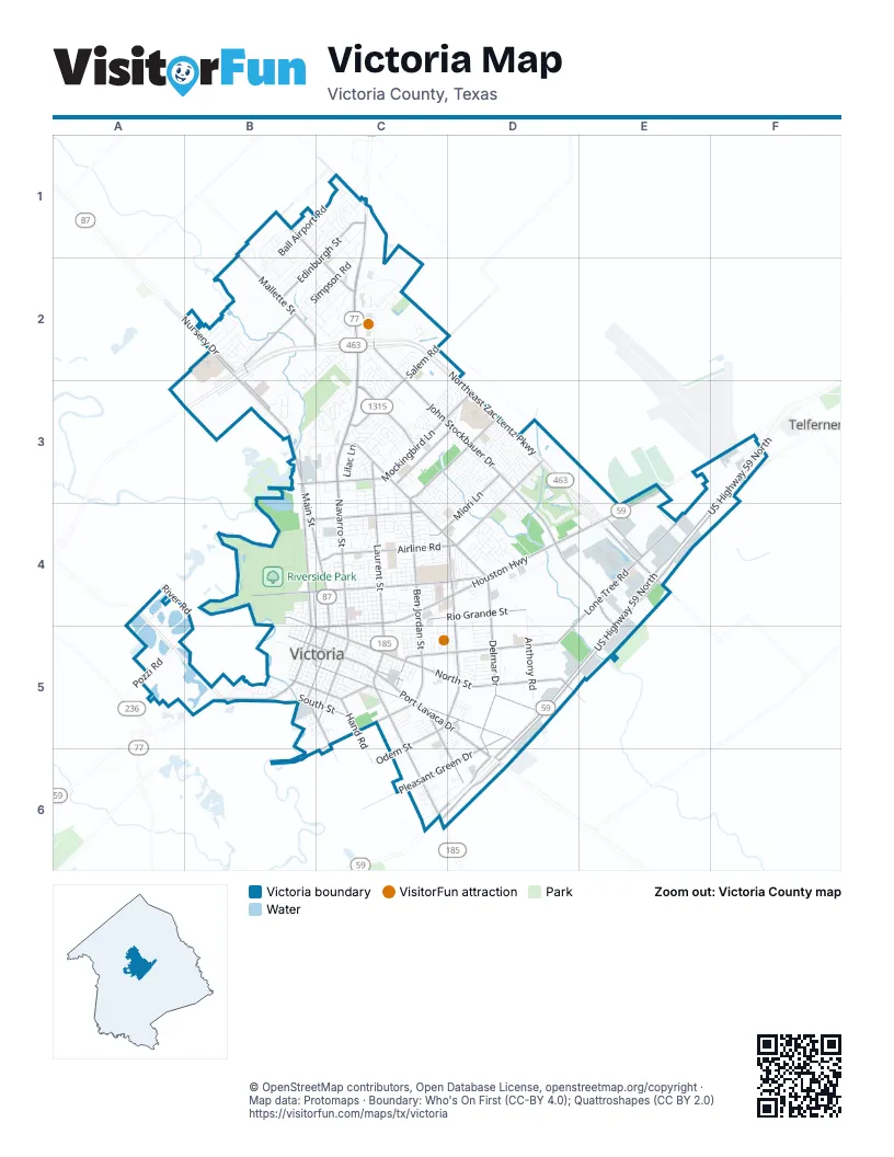
Street index of Victoria
Each street on the sheet and the grid squares it crosses.
- Northeast Zac Lentz ParkwayB2, C2, D2, B3, D3, E3, D4, E4
- Northwest Zac Lentz ParkwayB2, B3
- North Navarro StreetC1, C2, C3, C4, C5
- Houston HighwayE3, C4, D4, E4
- North Main StreetB2, B3, B4, C4, C5
- North Laurent StreetC3, C4, C5
- East Rio Grande StreetC4, D4, C5
- Port Lavaca DriveC5, D5, D6
- South Laurent StreetC5, C6
- Southwest Moody StreetB5
- US Highway 87 NorthB2
- Southeast Zac Lentz ParkwayE4
- East Goodwin AvenueC5
- North Moody StreetB4, B5, C5
- South Moody StreetB5
- West Rio Grande StreetC5
- US Highway 59 NorthF3, E4, F4, D5, E5, C6, D6
- North John Stockbauer DriveC2, C3, D3, D4
- East Airline RoadD3, C4, D4
- Sam Houston DriveC3, C4, D4
- East Mockingbird LaneC3, D3
- North Ben Wilson StreetD4, D5
- Salem RoadC2, C3
- Guy Grant RoadC3
- Odem StreetC5, D5, C6
- West Goodwin AvenueB5, C5
- West Mockingbird LaneB3, C3
- South Ben Wilson StreetC5, D5
- West Airline RoadC4
- Laurent StreetC5
- Lone Tree RoadD4, E4, C5, D5
- North Ben Jordan StreetC3, D3, C4, C5
- East Juan Linn StreetB5, C5, D5
- North Vine StreetB3, B4, B5
- East North StreetC5, D5
- Delmar DriveD4, D5, D6
- East Red River StreetC4, D4
- Mallette StreetB1, B2
- Pleasant Green DriveD5, C6, D6
- Edinburgh StreetC1, B2, C2
- Glascow StreetB1, C1, C2
- Nursery DriveA2, B2, B3
- Hanselman RoadD5
- South John Stockbauer DriveD4, E4
- Southwest Ben Jordan StreetC5, C6
- East Crestwood DriveC4
- Miori LaneD3, C4, D4
- Leary LaneC3, D3
- Callis StreetC5, C6, D6
- Briggs BoulevardB2
- Ben Jordan StreetC3, D3
- West Red River StreetB4, C4
- Burroughsville RoadE4
- Northside RoadC1
- South Navarro StreetC5
- Bottom StreetB5, C5
- East South StreetB5, C5
- West North StreetB4, B5, C5
- South Liberty StreetB5, C5
- Lonetree RoadE4
- Hand RoadC5
- East Water StreetB5, C5
- Northeast Water StreetC5
- North Ben Jorden StreetD3
- Avenue CC5
- County RoadF3
- West Water StreetB5
- Bianchi DriveB1
- West Crestwood DriveB4, C4
- Paco RoadB1
- South Ben Jordan StreetC5
- Mc Cright DriveB4
- North Cameron StreetC4, C5
- East Mistletoe AvenueD3, C4
- Ball Airport RoadB1, C1, B2
- Anthony RoadD4, D5
- East Colorado StreetC4
- Country Club DriveC2, C3
- North Wheeler StreetC4, C5
- North de Leon StreetC4, C5
- Blyth RoadB1, C1, B2
- North Nimitz StreetC3, C4, C5
- Placido BenavidesC2
- Park AvenueC4, D4
- North East StreetC4, C5
- East Brazos StreetC4
- East Sabine StreetC4
- Anaqua AvenueC4
- East Virginia AvenueC4
- North Liberty StreetC4, C5
- North Jecker StreetC4, C5
- East San Antonio StreetC4
- East Rosebud AvenueC4
- East Warren AvenueC4
- Lova DriveD4, D5
- East Power AvenueC5
- Halsey StreetC3, C4, C5
- North Depot StreetC4, C5
- East Guadalupe StreetC4
- Memorial DriveB4
- East Commercial StreetC5
- Angus StreetC1, B2
- Taos DriveD3
- Dundee StreetB1, C1, B2
- North Bluff StreetB4
- Loma Vista AvenueC4, D4
- Wildwood StreetD4, C5
- East Trinity StreetC4
- East Stayton AvenueC5
- Levi StreetC4
- North Bridge StreetC4, B5, C5
- East Constitution StreetC5
- Charleston DriveD3, D4
- North Glass StreetC4, B5, C5
- South Depot StreetC5
- Simpson RoadB2, C2
- Broadmoor StreetB1, C1, C2
- Eisenhower StreetC4, C5
- Westwood StreetD4
- Lilac LaneC3
- East Mesquite LaneC4
- East Santa Rosa StreetC5
- Sherwood DriveD4
- Goldman StreetC4, C5
- Champions RowB2, C2, B3
- Mead RoadB2, C2
- North Louis StreetC4, C5
- East Forrest StreetC5, D5
- Berwick StreetB1, B2
- South Wheeler StreetB5, C5
- East Larkspur StreetC2
- College DriveC4, D4
- Northgate RoadC1, C2
- Pennsylvania AvenueC3, D3
- Dudley StreetC6, D6
- East Poplar AvenueC4
- Meadowlane AvenueD4, C5, D5
- East Mimosa AvenueC4
- Azalea StreetC4
- Buena Vista AvenueC4
- South Cameron StreetC5
- East Nueces StreetC4
- South de Leon StreetB5, C5
- Pozzi RoadA5
- Santa Fe DriveD3
- Lawndale AvenueC3, C4
- Perth StreetB1, B2
- Monterrey DriveC3
- Dairy RoadC2, C3
- Profit StreetC4, D4, C5, D5
- East Polk AvenueC3
- Bon Aire AvenueC4, D4
- Bingham RoadC2
- Kelly Crick RoadB2, C2
- Spring Creek RoadB3, C3
- Ashland CreekD3
- Locust AvenueC4, D4
- East Convent StreetB5, C5
- Maplewood DriveD4
- Plantation DriveC3
- Ash StreetC5
- Siegfried StreetB5
- South Main StreetB5, C5
- East Hiller StreetC4, D4
- Allendale StreetC5, D5
- South Glass StreetB5
- West Constitution StreetB5, C5
- Mac Arthur StreetC4, C5
- South Bridge StreetB5
- East Murray StreetB5, C5
- Oleander DriveC4
- Chimney Rock DriveB2
- East Loma Vista StreetC4
- East Oak StreetC5
- West Stayton AvenueB4, B5, C5
- North Craig StreetB4, B5
- Brocton DriveD3
- Rosewood DriveD4
- Walnut AvenueC4
- South William StreetB5, C5
- West Nueces StreetB4, C4
- Berkshire LaneC3
- Rhodes RoadB2, C2
- Brooks RoadB2, C2
- Cannon RoadC2
- River RoadA4, B4
- Masters DriveB2, C2
- Brushy CreekB1, B2
- West Commercial StreetB5, C5
- Hopkins StreetC5
- Erwin AvenueD3, C4, D4
- Berkman DriveB2, C2
- Glendale StreetC5, D5
- Woodlawn StreetC5, D5
- Morningside StreetC5, D5
- Colony Creek DriveD3, D4
- Retama StreetC3, C4
- Arroyo DriveC4
- North Washington StreetB4, B5
- Bluebonnet StreetC4
- King Arthur StreetC2, C3
- Gayle StreetD5
- Linda DriveD5
- Hollywood BoulevardC3
- Dunbar DriveD3
- Cobble Stone CourtB1
- Tropical DriveB2
- Wayne Watkins DriveE4
- Victoria Mall DriveC2
- Rhinegold StreetB5
- Fillmore AvenueC3
- Oaklawn StreetD4
- North William StreetC5
- Redwood DriveC4
- Smith RoadA4
- Walker DriveC4, D4
- La Valliere StreetC4, C5
- West Power AvenueB5, C5
- Greenwood DriveC4
- Palmetto AvenueC4
- Avondale StreetC5, D5
- Pine StreetC5
- Swan DriveD5
- Oldach RoadB2, C2
- Legend DriveD3
- Cypress StreetD4
- Paisano DriveD3
- Yucca DriveB2
- Navajo DriveD3
- West Colorado StreetB4, C4
- Leisure LaneC3
- West Brazos StreetB4, C4
- Larkspur StreetC2
- Joplin StreetC1
- Kingsway StreetC3
- East Church StreetB5, C5
- Flamingo DriveD5
- Shiloh DriveC3
- Williamsburg AvenueC3, D3
- Tanglewood DriveD4
- Cedar StreetD4
- Evergreen StreetC3
- Buckingham StreetC2
- West San Antonio StreetB4, C4
- North Victoria StreetB4, B5
- East 3rd StreetB5, C5
- Woodway DriveB2
- East River StreetB5, C5
- South Vine StreetB5
- East 2nd StreetB5, C5
- Queenswood TrailD3
- Melrose AvenueC4
- Morninglory LaneC3
- Bedivere DriveC2, C3
- Northampton CircleD3
- Travis AvenueC3, C4
- Smith StreetB4
- Bridle LaneC1
- North George StreetC5
- Avenue DC5
- Timberlane DriveD3
- Bramble Bush LaneC3
- Bobolink StreetD5
- Antietam DriveC3
- Glenmore StreetB1, C1
- Kelly DriveC2
- Byron LaneD3
- Tampa DriveC3
- Lenora DriveC3, C4
- Navidad StreetC4
- Tibiletti RoadA5, B5
- Londonderry DriveD3
- Parsifal StreetB5
- East Magruder DriveB3, C3
- Guinevere StreetC3
- Neu RoadB2, C2
- Newhaven AvenueC3, D3
- John F Lee DriveB4
- Beechwood DriveD4
- Creekridge DriveB3
- Dahlia LaneC3
- North Star DriveC3
- Tibiletti DriveD4, D5
- Ivanhoe DriveD3, D4
- Catalpa StreetD4
- North Brownson StreetC5
- Woodlands LaneB2, B3
- Auburn HillB2
- Kingwood DriveD3
- North West StreetB4, B5
- West Forrest StreetB5, C5
- Windy Way DriveC2
- Regency AvenueC3
- South Victoria StreetB5
- LaSalle CrossingC2
- RiataD3
- Southwest Ben Jordan Street WestB6, C6
- Turtle Rock DriveB2
- Appaloosa DriveC1
- Silverado TrailD3
Things to do on the Victoria map
Places on the map
- Advance Auto Parts
- ALDI
- Americas Best Value Inn & Suites
- Cade Middle School
- Citizens Medical Center
- Crain Middle School
- Dad's RV Park
- DeLeon Elementary School
- DeTar Hospital Navarro
- DeTar Hospital North
- Dudley Elementary School
- Ethel Lee Tracy Park
- Evergreen Cemetery
- Field of Dreams Sports Complex
- Gateway to the Gulf RV Park
- Hopkins Elementary School
- Hopkins Park
- Howell Middle School
- Memorial Park
- Patti Welder Middle School
- Resurrection Catholic Cemetery
- Riverside Golf Course
- Riverside Park
- Rowland Elementary School
- Smith STEM Academy
- STEM Middle School
- Ted B Reed Park
- Texas Port Recycling
- The Club at Colony Creek
- Torres Elementary School
- Vickers Elementary School
- Victoria Country Club
- Victoria Crossing
- Victoria East High School
- Victoria Mall
- Victoria RV Park
- Victoria Square
- Victoria West High School
- Victoria Youth Sports Complex
- Walmart Supercenter
Next to Victoria
- Telferner
© OpenStreetMap contributors, Open Database License, openstreetmap.org/copyright · Map data: Protomaps · Boundary: Who's On First (CC-BY 4.0); Quattroshapes (CC BY 2.0)