

Texas map
Victoria County map
About 91,949 people live here (Census Bureau, 2024 estimate). The sheet's index lists 300 streets; Salem Road, Wood Street and Upper Mission Valley Road cross the most grid squares. Things to do inside the boundary: Discover Victoria Visitor Center and Victoria Mall.
Open the map (PDF, US Letter)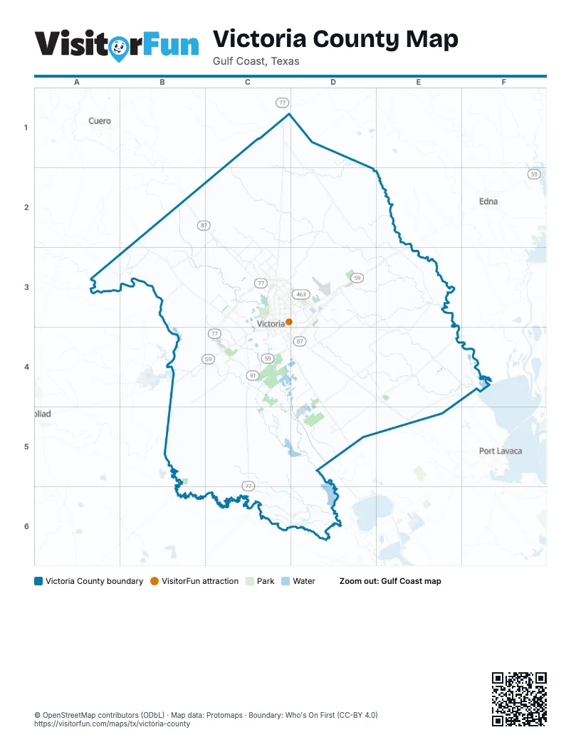
Maps inside Victoria County
1 map inside, from the street map of Victoria County down.
Street index of Victoria County
Each street on the sheet and the grid squares it crosses.
- Northwest Zac Lentz ParkwayC3, C4
- Northeast Zac Lentz ParkwayC3, D3
- US Highway 77 SouthC4, C5
- North Navarro StreetC3
- Houston HighwayC3, D3
- US Highway 59 SouthC4
- US Highway 87 NorthC2, C3
- Shepley StreetD4, D5
- Southwest Moody StreetC4
- North Main StreetC3
- North Laurent StreetC3, C4
- East Rio Grande StreetC3, D3
- Dupont RoadD4, D5
- Spur 91C4
- Port Lavaca DriveC3, C4, D4
- South Laurent StreetC4
- Southeast Zac Lentz ParkwayD3
- East Goodwin AvenueC3, C4
- North Moody StreetC3
- South Moody StreetC3, C4
- Northwest Zac Lenz Parkway Frontage Road EastC4
- State Highway 185 NorthD5
- West Rio Grande StreetC3
- North Holzheauser LaneE3
- Wood StreetD3, E3, D4, E4
- Upper Mission Valley RoadB2, B3, C3, C4
- US Highway 59 NorthD3, C4, D4
- Salem RoadC1, D1, D2, C3, D3
- North John Stockbauer DriveC3, D3
- East Airline RoadC3, D3
- Sam Houston DriveC3, D3
- East Mockingbird LaneC3, D3
- North Ben Wilson StreetC3, D3, C4, D4
- Guy Grant RoadC3
- Commerce StreetC3, E4, D5
- Holzeauser RoadE3
- Odem StreetC4, D4
- Kolle RoadD2, E2
- Farm-to-Market Road 682C1
- West Goodwin AvenueC3
- Johnson StreetD5
- West Mockingbird LaneC3
- South Ben Wilson StreetC4
- Farm-to-Market Road 236B2
- West Airline RoadC3
- Laurent StreetC3
- Lake Placedo RoadE4, F4, E5
- Old Port Lavaca RoadD4, E4, E5
- Nursery DriveC2, C3
- Lone Tree RoadC3, D3
- Levi Sloan RoadC2, C3
- Hanselman RoadD3, D4
- Burroughsville RoadD3, D4
- Parsons RoadC2, C3
- North Ben Jordan StreetC3, D3, C4
- East Juan Linn StreetC3, C4, D4
- North Vine StreetC3
- East North StreetC3, C4, D4
- Garcitas Creek RoadE3
- Stubbs School RoadC4
- Oliver RoadC2, C3
- US Highway 77 Frontage RoadC4
- Delmar DriveD3, D4
- East Red River StreetC3, D3
- Pleasant Green DriveC4, D4
- Black Bayou Rd No 1D5
- Bottom StreetC4
- Hand RoadC4
- Mallette StreetC3
- Northside RoadC2, C3
- Edinburgh StreetC3
- Glascow StreetC3
- Southwest Ben Jordan StreetC4
- South John Stockbauer DriveD3
- East Crestwood DriveC3
- Miori LaneC3, D3
- Chaparral DriveC4
- Leary LaneC3
- Callis StreetC4, D4
- Briggs BoulevardC3
- Houston StreetD4, E4, D5
- Bob White RoadC4
- Ben Jordan StreetC3, D3
- West Red River StreetC3
- Paco RoadC3
- Haynes RoadC3
- South Navarro StreetC3, C4
- Bianchi DriveC3
- Hill RoadD3
- Spur 91 Frontage RoadC4
- East South StreetC4
- East East Hatchett AvenueD5
- West North StreetC3
- South Liberty StreetC3, C4
- County RoadD3
- Lonetree RoadD3
- East Water StreetC4
- Matchett RoadD4
- Northeast Water StreetC4
- Hill StreetD3
- North Wood StreetE4
- North Ben Jorden StreetD3
- Avenue CC3, C4
- South Williams StreetE4
- FM 446C4
- 2nd Street WestD5
- West Water StreetC4
- West Crestwood DriveC3
- South Ben Jordan StreetC4
- Castillo StreetC2
- Farm-to-Market Road 1685C3
- J-2 Ranch RoadD1, C2, D2, E2
- San Antonio River RoadB5, C5, C6
- Nursery RoadC1, C2
- Fordtran RoadC1, B2, C2
- Lower Mission Valley RoadB2, B3, C3
- Coletoville RoadB3, C3, B4
- Old Highway RoadD3, E3
- Midway RoadD3, E3, E4
- Matthews RoadC4, B5, C5
- Wood Hi RoadD3, D4
- McCoy RoadD4, D5
- Lander RoadD5, E5
- Ragsdale RoadE3
- Keeran RoadE3, E4
- Old Goliad RoadC4
- Levee RoadD5
- Key RoadD4, D5
- Kohutek RoadC2
- Weber RoadB3
- Bayer RoadD4
- Coletoville Road EastB4, C4
- Kemper City Road WestB4, B5, C5
- Old Bloomington Road NorthD4, D5
- Kemper City Road EastC5
- Minatre RoadD3
- Henderson RoadD4, E4
- Tipton RoadD3, E3
- Fordyce RoadC4
- Arnold RoadB3
- Benbow RoadD2, D3
- Berger RoadB3
- Johnson RoadE4
- Boehm RoadD4
- Venglar RoadE3
- Warburton RoadC5, C6
- Crouch RoadD4
- Pickering RoadD4, E4
- Gin RoadD3, E3
- Cologne RoadB4
- Beck RoadD3
- Old Green Lake RoadD5
- Diebel RoadB3, B4, C4
- Kemper City Road SouthC5
- Lasalle RoadE3
- Traylor RoadD5
- Albrecht RoadB2
- Old Refugio RoadC5
- Guadalupe RoadD4
- River RoadC3
- Tate RoadC2, C3
- Mc Cright DriveC3
- Garrett-Gonzales School RoadC1
- Foster RoadC1, D1
- Black Bayou No 2D5
- Raab RoadC2, C3
- Fox RoadC4
- Menke RoadD4
- Vaughn Road SouthD1
- Reinecke RoadB2, B3
- Murphy RoadC5
- Raven RoadD4
- McFaddin Road NorthD6
- Vaughn RoadD1
- Willow Creek Ranch RoadC2
- Beck Road EastD3
- North Cameron StreetC3
- Wilson RoadD2
- Bankhead RoadE3
- Waida RoadD4
- Brownson RoadD4
- Bischoff RoadE2
- Nagel RoadB3
- Gentry RoadD2, E2
- Ocelot RoadE3
- Bent Oaks DriveE2
- Shiller RoadE4
- Wischkaemper RoadD3, D4
- Hambleton RoadD3
- Ball Airport RoadC3
- Phillips RoadD5
- Dentler RoadA3, B3
- Old Bloomington RoadD5
- Otto RoadE3
- Placido BenavidesC3
- Noll RoadA3
- Givens RoadC4
- Hood RoadE3, E4
- East Mistletoe AvenueC3, D3
- Beck Road WestC3, C4
- Morris Town RoadC5
- Hiller RoadD3, E3, C4
- Malik RoadD4, D5, E5
- Levi RoadD4, D5
- Adcock Dairy RoadC3
- Brady RoadC1, D1
- Schubert RoadB4
- Nickel Ranch RoadE2
- Kings RoadD5
- Rupley Lake RoadC4, D4
- Parsifal StreetC4
- Kolodzey RoadB3
- Live Oak DriveD3, E3
- Hosek RoadD3, D4, E4
- Westpark AvenueC3
- Anthony RoadD3, D4
- Park AvenueC3, D3, D5
- Timber DriveC3, C4
- East Colorado StreetC3
- Tipton Road WestD3, D4
- Vogt RoadD4
- Repka RoadE3
- Country Club DriveC3
- North Wheeler StreetC3
- Shiller Road WestE4
- Cushman RoadC6
- North de Leon StreetC3
- York RoadD4
- Blyth RoadC3
- Ohrt RoadB3
- North Nimitz StreetC3
- Cooley RoadA3
- Miller RoadD3, E3
- Kobitz RoadB4
- Buentello RoadC5
- Albrecht Road WestB2, B3
- North Depot StreetC3, E4
- Mc Neil Ranch RoadC3
- Faltysek RoadD4
- Hodde's CircleD5
- Schlebach RoadF4
- Pickering Road WestD4
- Mumphord RoadD4
- North East StreetC3
- Hollybrook DriveD2, D3
- Basswood DriveC3
- Bliss DriveC2
- Hensely RoadC1
- Nursery Drive NorthB2, C2
- Rodeo RoadD2, D3
- South Price RoadD4
- East Brazos StreetC3
- Moritz RoadA3
- Sunray RoadE4, E5
- Cologne Road SouthB4, B5
- Dodd RoadE3
- Lala LaneD4, E4
- East Sabine StreetC3
- Villafranca Ranch RoadC3
- Groll LaneB3
- Coletoville Road WestB4
- Anaqua AvenueC3
- Patterson LaneB3
- Kemper RoadE4, E5
- Church LaneB3
- Burkhart RoadD4
- East Virginia AvenueC3
- Wischaemper School RoadD4
- Bois D Arcade LaneD4
- North Liberty StreetC3
- North Jecker StreetC3
- East San Antonio StreetC3
- Bottom RoadC4
- East Rosebud AvenueC3
- Sendera LoopC2
- Schmidt RoadE3
- Bayer Road EastD4
- Love RoadC2
- South Depot StreetC3, C4, E4
- East Warren AvenueC3
- Lova DriveD3, D4
- Reeves Ranch Park RoadB4
- Crawford DriveC3
- Airline RoadD3
- East Power AvenueC3
- Canal RoadD4, D5
- Halsey StreetC3
- Wigington LaneD2, D3
- East Guadalupe StreetC3
- King RoadE3, C4
- Sunset DriveB3, D3
- Burroughs RoadD2
- Memorial DriveC3
- H K Ranch RoadE3, E4
- Hunters CircleC4
- Pozzi RoadC3, C4
- East Commercial StreetC3, C4
- Edna Lane NorthD5
- Fannin RoadB5
- Frantis RoadE3
Things to do on the Victoria County map
Places on the map
- Alligator Lake
- Aloe Elementary School
- Bass Lake
- Cade Middle School
- Citizens Medical Center
- Crain Middle School
- Dad's RV Park
- DeLeon Elementary School
- DeTar Hospital Navarro
- DeTar Hospital North
- Dudley Elementary School
- Dupont Cooling Basin
- Ethel Lee Tracy Park
- Evergreen Cemetery
- Field of Dreams Sports Complex
- Gateway to the Gulf RV Park
- Goldmans Hill
- Hopkins Elementary School
- Hopkins Park
- Howell Middle School
- Indian Mound
- Linn Lake
- McDonough Lake
- Memorial Park
- Memory Gardens Cemetery
- Out Law Pass
- Patti Welder Middle School
- Pridham Lake
- Resurrection Catholic Cemetery
- Riverside Golf Course
- Riverside Park
- Southbound RV Park and Cabins
- The Club at Colony Creek
- Victoria
- Victoria Country Club
- Victoria Crossing
- Victoria East High School
- Victoria Mall
- Victoria West High School
- Victoria Youth Sports Complex
Next to Victoria County
- Cuero
- Edna
- Goliad
- Port Lavaca
© OpenStreetMap contributors, Open Database License, openstreetmap.org/copyright · Map data: Protomaps · Boundary: Who's On First (CC-BY 4.0); Quattroshapes (CC BY 2.0)