

Texas map
Waxahachie map
About 48,617 people live here (Census Bureau, 2024 estimate). The sheet's index lists 300 streets; North Interstate 35E, Howard Road and North US Highway 77 cross the most grid squares. Also on it: Lake Waxahachie, Brown Singleton Park and Citizens Convenience Station.
Open the map (PDF, US Letter)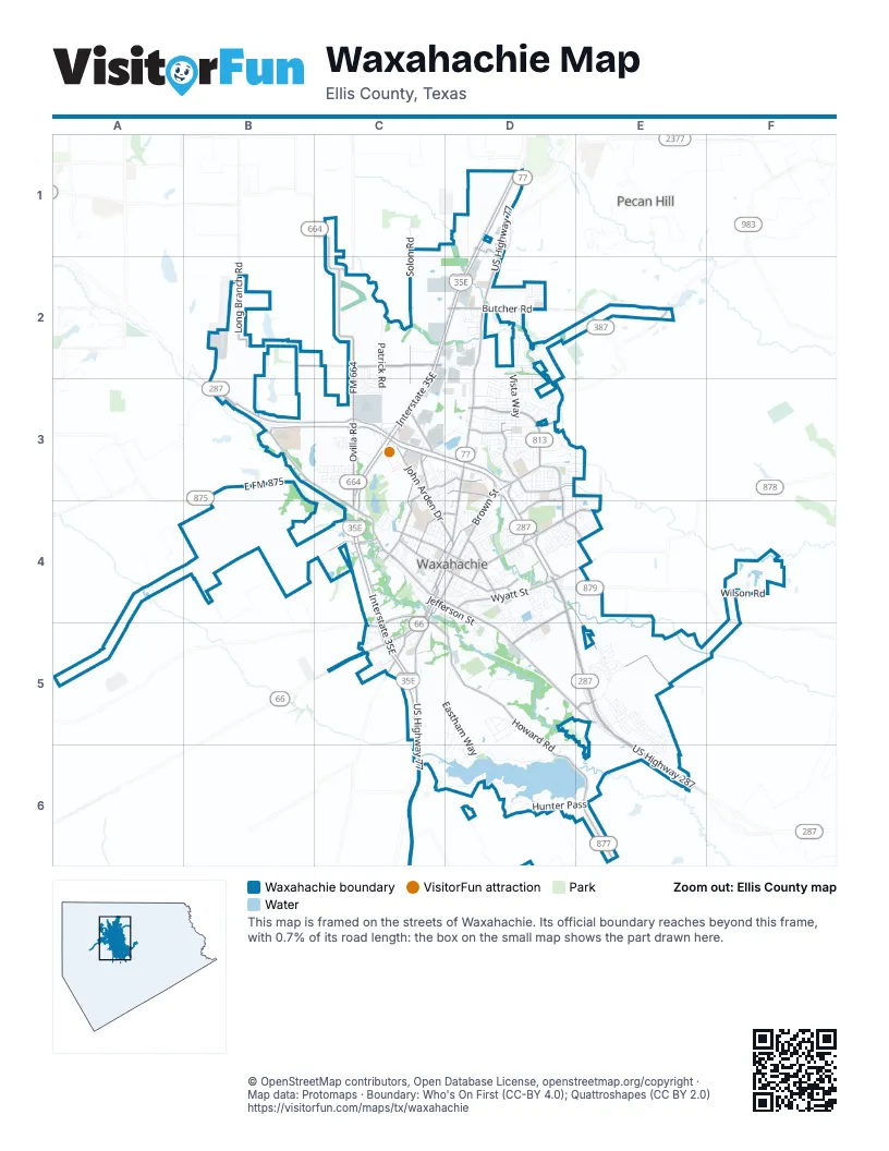
Street index of Waxahachie
Each street on the sheet and the grid squares it crosses.
- North US Highway 77D1, D2, D3, D4
- South US Highway 287 BypassD4, D5, E5
- South US Highway 77C5, C6
- South US Highway 287E5, E6
- East US 287 BusinessD5, E5
- West US 287 BusinessB3, C3, C4
- West Main StreetC4
- Ferris AvenueC4, D4
- Dr Martin Luther King Jr BoulevardD4, D5
- West US Highway 287B3
- West US Highway 287 BusinessB3
- South Highway 77C4, C5
- Highway 77C5
- North Monroe StreetC4, D4
- South Monroe StreetC4
- North Elm StreetC4
- South Elm StreetC4
- East Main StreetC4, D4
- East US Highway 287B3
- South State Highway 342D1
- North Interstate 35ED1, C2, D2, C3, C4
- West US Highway 287 BypassB3, C3, D3
- South Interstate 35EC4, C5
- Howard RoadC4, C5, D5, D6, E6
- East US Highway 287 BypassD3, D4
- FM 664C1, C2, C3
- Solon RoadC1, C2, C3, C4
- Brown StreetD3, D4
- East North Grove BoulevardD3
- Wyatt StreetD4
- Ovilla RoadC3, C4
- Butcher RoadD2
- East Marvin AvenueD4
- East FM 875B3
- Farm-to-Market 66C5
- South Rogers StreetC4, C5
- West Marvin AvenueC4, D4
- Grand Avenue NorthC3, C4
- FM 813E2, D3
- Brookside RoadC4
- Farm to Market 878D4, E4
- North Grand AvenueC4
- Solon Place WayC3, C4
- Farm To Market 387E2
- West Butcher RoadD2
- Ennis StreetD4
- Sardis RoadB3
- West North Grove BoulevardD3
- Connecting RoadC5
- Parks School House RoadD4, E4, D5, E5
- Marshall RoadB2, C2
- Broadhead RoadE3, D4, E4
- John Arden DriveC3, C4, D4
- Long Branch RoadB2
- Garden Valley ParkwayD3, D4, E4
- Farley StreetD4
- Cantrell StreetC4, C5
- West Ross StreetC4, D4
- Dean Box DriveD3
- Sagebrush LaneD3
- East University AvenueC4, D4
- Northgate DriveC3, D3
- East Ross StreetD4
- South College StreetC4, C5
- Park Place BoulevardD4
- Bessie Coleman BoulevardD3
- Indian DriveD3
- Five Points RoadC5
- Bryson StreetC4, D4
- Richmond LaneD4
- North College StreetC4, D4
- Lofland DriveC2
- East Sterret RoadD1
- West Sterret RoadD1
- Blackсhamp RoadB2, B3
- South Westmoreland RoadC2
- Sam George DriveC3
- South Grand AvenueC4
- Kelley BendC4
- Shawnee RoadD1
- Patrick RoadC2, C3
- Vista WayD2, D3
- Lakeshore DriveD6
- Grove Creek RoadD2, D3
- Hunter PassD6, E6
- Pine Meadows EstatesC5
- East Jefferson StreetC4, D4, D5
- West Jefferson StreetC4
- West Sterrett RoadC1, D1
- Saratoga DriveE5
- Eastham WayD5, D6
- Alton Adams DriveD2
- Sycamore StreetC4, D4
- Lone Elm RoadA4, B4
- Hedgewood DriveD3
- Country Meadows BoulevardD3
- Lions Park RoadD5
- Water StreetC4
- North Gibson StreetC4, D4
- Peters StreetD4, D5
- Highland AvenueC4
- Gingerbread LaneC3, C4
- East Highland RoadD1
- Lakewood DriveC6, D6
- Dartmoor DriveE5
- Reynolds CircleC4
- Kaufman StreetD4
- Spring Creek DriveD3
- South Hawkins StreetC4
- Wilson RoadF4
- Williams StreetD4
- Equestrian DriveD3
- Red Maple RoadD3
- Katy Lake DriveC4
- River Oaks BoulevardD4
- Santa Fe TrailD3, D4
- Waterfront DriveD6
- Dunn StreetD4
- Acess RoadC3, D3
- Lake Park AvenueD4
- Liv Meadow WayD5
- Laguna Vista RoadD5, D6
- Hackney StreetD3
- North Town BoulevardD3
- Cynisca StreetC4
- Mountain Laurel DriveE5
- Strait LaneD3
- Aiden DriveD5, C6, D6
- Thoroughbred StreetE5, E6
- South Hill DriveD3
- Unbridled RoadE5
- Ash DriveD5, D6
- Chenault DriveC3, D3
- Virginia AvenueC4
- Old Italy RoadD5
- Granite WayD3
- Half Moon DriveD4, E4
- Kirven AvenueC4
- Pimlico DriveE5, E6
- East Parks AvenueD4
- North Star LaneD3, D4
- Haven RoadD3
- Hundred Acre DriveD2
- Old Spanish TrailC2, C3
- Washington AvenueD3
- Graham StreetD4, D5
- Brookstone DriveD2
- Coleman StreetD4
- Lion's ParkD5
- Baylor WayC3
- Territorial WayC3
- North Getzendaner StreetD4
- Blue Star DriveC3
- Getzendaner Mem ParkC4
- Harbin AvenueC4
- Lana Garden WayD5
- Bear TrailD4
- Matthews StreetC4, D4, D5
- Brown Industrial RoadC2, D2
- Dart WayD3
- Buckskin DriveC3
- Saddlebrook LaneD3
- Charismatic RoadE5
- Columbia AvenueC3, C4, D4
- Brookbend DriveD2
- Carlton ParkwayD2
- Old Bridge RoadD3, E3
- Hacienda DriveD3
- Valley View DriveC2, C3
- North Rogers StreetC4, D4
- Austin RoadC2
- Monticello DriveD4
- Big Sky DriveC2
- North Jackson StreetC4, D4
- Sheppards LaneC3
- Whispering Trail DriveD3
- Aria DriveC5, D5
- Stadium DriveD3
- Sapphire LaneD3
- Dunaway StreetC4, C5
- Bison Meadow DriveD4
- Wolf Creek DriveD3
- Scarlet Sage RoadE5
- Becky LaneD2
- Rex Odom DriveB2
- Old Settlers TrailC3
- Chesterfield CircleD2
- Pinto DriveD3
- Bent Creek DriveD2
- Country DriveD3
- Resting Place RoadD3
- Liriope LaneD2, D3
- Oak Creek DriveD3, E3
- Venture WayD2
- Blackwater TrailD2
- Boulder LaneC3
- Winchester WayD2
- Access RoadD3
- Cornell LaneC3, D3, D4
- West 2nd StreetC4, D4
- Lacy Oak LaneD3
- Lila Lake DriveD5
- Morene AvenueD4
- Modene AvenueD4
- Martha StreetC4
- Tulane DriveC3, C4
- Alexander DriveD4
- Memory LaneE3, B4, E4
- Meagan StreetD4
- West Parks AvenueC4, D4
- Vivian DriveD4
- Alliance BoulevardC3
- Kirksey StreetD4
- Abela DriveD2, D3
- Perry AvenueD4, D5
- Aanya LaneD5
- Iroquois LaneD3
- Myrtle AvenueD4
- Vanderbilt LaneC3, C4
- Harvest Grove DriveD3, E3
- Leopold TrailD3
- Brickman LaneD6
- Fortune DriveC3
- Humbold StreetC3
- McKenzie StreetD4
- Owen WayD5
- Avalon DriveD4
- Cantle StreetD3
- Chisholm TrailC6
- Floyd StreetC4, D4
- Swan Lake DriveE6
- University AvenueC4
- Lincoln RoadC5
- Slate DrC3
- Dunlap StreetD4
- Clearlake DriveD4, D5
- Nocona DriveD3
- Wildflower DriveD3
- Shinnery Oak WayE5
- Sierra DriveC2, C3
- Mushroom RoadD2
- Pensacola AvenueD4
- Homestead LaneD5, D6
- Water Garden DriveD3
- West University AvenueC4
- North Patrick StreetC4
- East Criddle StreetD4
- Valley Oak TrailD3
- Buffalo Creek DriveD3, D4
- Horseshoe Bend DriveD3, D4
- Mustang Creek DriveD4
- Cardinal RoadD2
- Mc Millan StreetC4, D4
- Majestic Oak LaneD3
- Barger DriveD4
- Gayleh LaneD4
- Blackchamp RoadB2
- Park Hills DriveC5
- Post Oak DriveD4
- Pinnacle DriveD4
- Hilltop DriveC5
- RVG ParkwayC3
- Hideway StreetD6
- Industrial DriveD2
- Palomino DriveD3
- Willowcrest DriveD6
- Colter DriveC2, C3
- Railroad StreetC4
- Gridiron DriveC3
- Camden DriveD4
- Sadler StreetD4
- Chestnut RoadE5, E6
- Etta AvenueD4
- North Hawkins StreetC4
- Arborside DriveD3
- Burrow DriveC3
- Garden Grove DriveD3
- YMCA DriveD3
- Big Bend BoulevardC3, D3
- Windermere StreetD2
- Oldham StreetD4
- Bush AvenueD3
- Arden AvenueC5
- Leisure LaneD4
- Corporate ParkwayD2
- Oregon TrailC3
- Mark TrailD3
- Arrow Wood RoadD4, E4
- Lakebrook DriveD4
- Nandina WayC3, D3
- Pink Velour RoadE5
- Amherst DriveC3, D3
- Vermont StreetD5
- Olive StreetC4, D4
- Pierce StreetD3
- Ellis StreetC5
- Rams Horn DriveC3
- Civic Center LaneC3
- Windy Hill LaneC3
- Victoria StreetD3
Places on the map
- Boat Dock Park
- Brown Singleton Park
- Chapman Park
- Citizens Convenience Station
- Coleman Junior High School
- Country Lane Seniors
- Crystal Lake
- Dunaway Elementary School
- Eddie Finley Sr Junior High School
- Fraternal-Wakefield Cemetery
- Getzendaner Memorial Park
- Hillcrest Burial Park Cemetery
- Katy Lake
- Lake Waxahachie
- Lee Penn Park
- Life High School Waxahachie
- Life Middle School Waxahachie
- Lions Park
- Lumpkins Stadium
- Marvin Elementary School
- Matthews Park
- Mustang Creek Park
- Northgate Plaza
- Northside Elementary School
- Posten Gardens
- QuikTrip
- Roland's Nursery & Landscaping
- Shackelford Elementary School
- Soil Conservation Service Site 13 Reservoir
- Soil Conservation Service Site 17 Reservoir
- Spring Park
- Texas Baptist Home
- The Greenery
- Waxahachie Country Club
- Waxahachie Country Club Lake
- Waxahachie Crossing
- Waxahachie High School
- Waxahachie Marketplace
- Waxahachie Sports Complex
- Waxahachie Towne Center
Next to Waxahachie
- Pecan Hill
© OpenStreetMap contributors, Open Database License, openstreetmap.org/copyright · Map data: Protomaps · Boundary: Who's On First (CC-BY 4.0); Quattroshapes (CC BY 2.0)















