

Utah map
Cottonwood Heights map
About 32,437 people live here (Census Bureau, 2024 estimate). The sheet's index lists 300 streets; Fort Union Boulevard, Creek Road and Wasatch Boulevard cross the most grid squares. Also on it: Crestwood Park, Crestwood Park Trail and Old Mill Park.
Open the map (PDF, US Letter)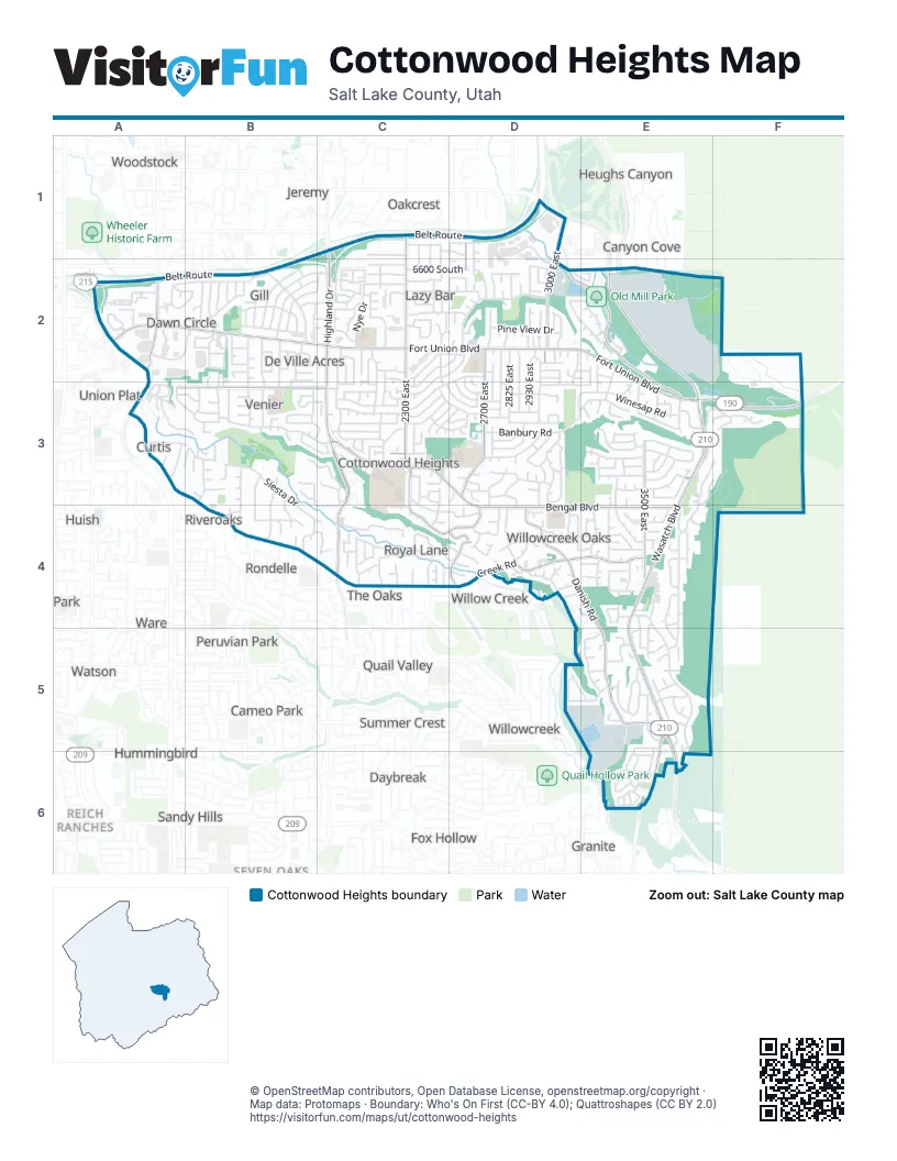
Street index of Cottonwood Heights
Each street on the sheet and the grid squares it crosses.
- Belt RouteC1, D1, A2, B2
- Wasatch BoulevardE2, E3, E4, E5, E6
- Fort Union BoulevardA2, B2, C2, D2, E2, E3
- Highland DriveC1, C2, C3, C4
- Union Park AvenueA2, A3
- 6200 SouthD1, E2
- Bengal BoulevardC3, D3, D4, E4
- Big Cottonwood Canyon RoadD1, D2, E2, E3, F3
- 3000 EastD1, D2
- 3500 EastE3, E4
- 1300 EastA2
- Little Cottonwood Canyon RoadE5, E6
- Creek RoadA3, B3, B4, C4, D4, E4
- Danish RoadD4, E4, E5
- 2300 EastC1, C2, C3
- 7200 SouthA3, B3, C3
- 2700 EastD2, D3
- Nantucket DriveC4, D4
- 2600 EastD1, D2, D3
- Oak Creek DriveD4
- 2325 EastC3, C4
- Willow Creek DriveD4
- Portsmouth AvenueD4
- 7220 SouthA3
- Forbush LaneB3
- Siesta DriveA3, B3, B4
- Prospector DriveE3, F3, E4
- Kings Hill DriveE4, E5
- Gun Club RoadE2, F2
- Hollow Mill DriveD2
- Canyon Estate DriveF2, F3
- Brookhill DriveB2, C2, B3
- Top Of The World DriveE4, E5
- Parkridge DriveB3, C3
- Camino WayC3
- Promenade DriveC2, C3, D3
- Cottonwood ParkwayD1, D2
- Meadow Downs WayB2, C2
- Royal LaneC4
- 6710 SouthA2, B2, C2, D2
- Banbury RoadD3
- Milne LaneA3, B3
- Meadow DriveB2, C2
- Chris LaneB2, B3
- Cavalier DriveD2, C3
- Forest Bend DriveB3, C3, B4, C4
- Brighton WayD3, D4
- Greenfield WayB2
- Mountain Oaks DriveE4
- Deer Creek RoadE4
- 6895 SouthC2
- Oakledge RoadE4
- Winesap RoadE3
- Macintosh LaneE2, E3
- Dolphin WayC3, C4, D4
- Brighton Point DriveE3
- Nutree DriveE2, D3, E3
- Campus DriveC2, D2, C3
- Cottonwood Cove LaneC4
- Scottish DriveE5
- Village RoadB2, C2
- Village Green RoadB2
- 2825 EastD2, D3
- Pine View DriveD2
- Forest Creek LaneB3, C3
- 2780 EastD2, D3
- 6670 SouthB2
- Danforth DriveD3, E3
- Cinnabar LaneC2, D2
- Dawn DriveA2, B2
- Bridgewater DriveD3
- Summer Hill DriveE3
- Towncrest DriveC2, C3
- Lonsdale DriveC3
- Caballero DriveB3, B4
- Cloverdale RoadB2
- Nye DriveC2
- Pinnacleterrace WayC3, C4
- Catalina DriveC2, D2, C3
- Sundown AvenueC2, D2
- 6600 SouthC2, D2
- 2870 EastD2, D3
- Park Centre DriveA2, B2
- Somerset DriveC3
- Hollow Dale DriveA2, B2
- Ponderosa DriveC2, C3
- Keswick RoadB3, B4
- Countrywoods CircleA2
- Alpen WayE5
- Vista Grande DriveD2, E2
- Waterside CoveA3
- 2930 EastD2, D3
- Santa Cruz DriveB2
- Supernal WayE4, E5
- Chadbourne DriveE4
- Davinci DriveD4, E4
- Eastbourne DriveC3, D3
- Sutton WayE5
- Cypress WayC3, D3
- Royal Harvest WayC2
- Lorita WayC4
- Walker Mill DriveD2, E2
- Castle Hill AvenueC3
- La Cresta DriveB2, C2
- Westerling WayD3
- 1700 EastB2, B3
- 1620 EastB2
- Enchanted Hills DriveE3
- Butler Hills DriveC3
- Willow Stream DriveC4
- 2200 EastC2, C3
- Cardinal WayC3
- Villaire AvenueC3
- 1950 EastB3, C3
- 7375 SouthD3
- Rich WayB3, C3
- Russell Park RoadE5
- 7180 SouthA3, C3, D3
- City View DriveF2
- 1495 EastB2
- Black Stone RoadC2
- Alta Hills DriveD5, E5
- De Ville DriveB2, B3
- Silver Lake DriveD3
- Anne Marie DriveD2
- Stone RoadD3
- Steffensen DriveD3, D4
- Pheasant Wood DriveB3, B4
- Danish Ridge WayD4
- Hidden Oak DriveE5
- 6720 SouthA2, C2
- 7635 SouthE3
- 2000 EastC2
- Walnut WayD3, E3
- Farm Brook WayC4
- Karin CourtC3
- Riverwood DriveB3
- Santiago LaneB2
- Daneborg DriveE5
- Greenhills DriveE5, E6
- Avondale DriveE3
- 6675 SouthC2
- Whitmore WayC2
- Country Manor RoadE3
- Dover Hill DriveE3
- Newport WayC3, C4
- Quicksilver DriveE3, F3
- Boulder DriveB2
- Pine Mountain DriveD2
- Stonehill LaneE4
- Stanwick RoadC1, C2
- Virginia Hills DriveD2
- 1710 EastB3
- 6630 SouthC2
- Curtis DriveB3, C3
- Grand Oak DriveE5
- 6525 SouthC1
- Brent LaneC2, C3
- 2740 EastD2, D3
- Scandia WayD4
- 2340 EastC2, C3
- 7110 SouthC2, D2
- Michelle WayA3
- Old Mill CircleD2, E2
- 6595 SouthC2
- Hidden Mill CoveE2
- Denmark DriveD4
- 2980 EastD3
- 1530 EastB2
- Canyon Centre ParkwayE3
- Broadwing LaneA2
- Sagebrush WayD2, D3
- Guntherwoods LaneC1, C2
- Kings Cove DriveE4, E5
- Pamela DriveD3, D4
- Rolling Knolls WayC2
- Titian StreetD4
- 2220 EastC2, C3
- Benecia DriveD2
- 6660 SouthC2
- 7020 SouthB2
- Honeycomb RoadE4
- Golden Hills AvenueE5
- 1540 EastB3
- Ellisonwoods AvenueC1
- Regatta LaneE6
- Cardiff RoadD3
- Artesian WayC2
- Olivet DriveA2, B2
- 2445 EastC2
- Timberline DriveE3, F3
- 2985 EastD2, D3
- Nod Hill RoadC1, C2
- 1600 EastB3
- Country Hollow DriveE3
- Dynasty WayE4, E5
- Creighton WayD2, D3
- Worchester DriveC3
- 7160 SouthB2, C2
- Norwood RoadE4
- Mountain Estates DriveE3, E4
- East Manor DriveD2, D3
- Willowcrest RoadE4
- 7335 SouthB3, D3
- Short Hills DriveE4
- Springbrook WayB2
- 1560 EastB2
- Stream View DriveC4
- Brighton Ridge DriveB3
- Cupecoy DriveD2
- Hunters Meadow CircleB4, C4
- Blue Jay LaneE5
- Racquet Club DriveE3
- 7230 SouthD3
- 7320 SouthD3
- Palo Verde WayB2
- Canterbury LaneD3
- Royal Farm DriveC2
- Bridgeport AvenueD4
- Danish Oaks DriveD4
- Cherry Tree LaneB2
- Pippin DriveE3
- Palma WayD2
- Wasatch Grove LaneE4
- 6450 SouthC1
- Grand Vista WayD4
- Jalais Hill LaneE6
- 2375 EastC3
- Coventry LaneD3
- Pine Cone StreetE2, E3
- Luna WayC2
- Antler WayE3
- Honeywood Cove DriveE4
- Juliet WayD2
- Magic View DriveE3
- Enchanted View DriveE3
- Galette LaneE6
- Carole DriveD3
- Dell RoadD3
- Shadow Ridge DriveA3
- Sugarloaf DriveD5, E5
- Cadens CoveC2
- Mystic Meadow LaneB3, B4
- Bouchelle LaneD1, D2
- Silver Fork DriveD3
- Susan WayC2, C3
- 7380 SouthB3
- Rustler RoadD5
- Tree Farm LaneE4
- 2520 EastD1, D2
- Country AvenueC1, D1
- Majestic Ridge DriveD4
- Sunhill RoadC3, D3
- Tompkins DriveC3
- Willowridge RoadE3
- Ridge Meadow LaneA3
- Towne DriveD3
- Morro StreetD2
- Hazelwood WayC2
- Danish Pine LaneD4
- Claret StreetD3
- Via Riviera WayD4, E4, E5
- 7240 SouthA3, B3
- 7350 SouthD3
- Biscayne DriveD3, D4
- Despain WayE5, E6
- Giverny ParkwayE6
- Marinda WayE3
- Reindeer DriveE2, E3
- Stone Mill DriveD2
- 2365 EastC1, C2
- 2425 EastC1, C2
- Courtland AvenueC2
- Jonathan DriveE3
- Lake Mary DriveD3
- Kings Hill PlaceE5, E6
- Monica CoveE2
- 2155 EastC2, C3
- 6485 SouthD1
- Camelback RoadC3, D3
- Monet LaneE6
- 1440 EastB3
- McCormick WayA3, B3
- Grandeur DriveB3
- 7070 SouthD2
- Viscayne DriveC3
- 3375 EastE4
- Greendale RoadB2
- Creek WayC4
- Pine Creek LaneC4
- Privet DriveA2
- La Vie LaneE6
- Manorly CircleD2
- Chalet CircleD4
- Eldon WayC4
- Old Ridge CircleD2
- Shadow CoveB2
- Cravalan CircleC4
- Regal Stream CoveC3
- 2485 EastC2
Places on the map
- 7-Eleven
- Alpha Coffee
- America First Credit Union
- American United Federal Credit Union
- Antczak Park
- Barnes & Noble
- Bella Vista Elementary School
- Berry Hill Park
- Big Cottonwood Canyon Park-N-Ride
- Big Cottonwood Canyon Park-N-Ride Overflow
- Big O Tires
- Brighton High School
- Butler Elementary School
- Butler Middle School
- Butler Park
- Bywater Park
- Canyon View Elementary School
- Canyons Church
- Carl's Jr.
- Castle Creek Inn
- Church of Jesus Christ of Latter-day Saints (Cottonwood Heights)
- Cottonwood Cyclery
- Cottonwood Heights City Hall
- Cottonwood Heights Recreation Center
- Cottonwood Paper Mill
- Cottonwood Post Office
- Courtyard Salt Lake City Cottonwood
- Crestwood Park
- Crestwood Park Trail
- Crestwood Pool
- Dan's
- Exxon
- Ferguson Park
- Mill Hollow Park
- Mountain View Memorial Estates
- Mountview Park
- Old Mill Park
- Target
- The UPS Store
- Waterside Cove
Next to Cottonwood Heights
- Alta Cove at Willow Creek
- Altawood
- Avalon Village
- Baker
- Belle Meadows
- Biscayne Park
- Cameo Park
- Canyon Brook Estates
- Canyon Cove
- Canyon View Estates
- Canyon Village
- Capistrano Villa
- Cottonwood Acres
- Country Estates
- Country Garden Estates
- Daybreak
- Driftwood Estates
- Essex Court Condo
- Fox Fire
- Fox Hollow
- Grandview Acres
- Granite
- Harvard Park
- Haven Grove
- Heughs Canyon
- Hidden Meadows
- Huish
- Hummingbird
- Jamestown
- Jeremy
- Kimberly Park
- Knudsens Corner
- Linden Circle
- Midvale Terrace
- Nalani
- Oakcrest
- Olympus View
- Peach Blossom Estates
- Pebble Glen
- Peruvian Park
- Ponderosa Estates
- Probe
- Quail Hollow
- Quail Point
- Quail Valley
- Quail Valley Subdivision Number 3
- Raintree Village
- Reich Ranches
- Ridge Point
- Ridgecrest
- Riveroaks
- Rondelle
- Sandy Hills
- Schneiter
- Seven Oaks
- Shadow Hills East
- Shady Brook Estates
- Shady Grove
- Sherwood Park
- Ski Haven Estates
- South Bridge Plat A
- Suburban View
- Summer Crest
- Summer Meadows
- Sunrise Meadows
- Terrace Circle
- The Oaks
- Three Fountains East Condominium
- Union Plat
- Valley Ridge
- Ware
- Watson
- Willow Cereek Road Terrace
- Willow Creek
- Willow Creek Heights
- Willow Creek Hills
- Willow Creek Terrace
- Willowcreek
- Woodstock
- Wren Lane East
© OpenStreetMap contributors, Open Database License, openstreetmap.org/copyright · Map data: Protomaps · Boundary: Who's On First (CC-BY 4.0); Quattroshapes (CC BY 2.0)















